Area of disturbed weather in the Caribbean
Moderator: S2k Moderators
Forum rules

The posts in this forum are NOT official forecasts and should not be used as such. They are just the opinion of the poster and may or may not be backed by sound meteorological data. They are NOT endorsed by any professional institution or STORM2K. For official information, please refer to products from the National Hurricane Center and National Weather Service.

Re: Area of disturbed weather in the Caribbean
I think it is interesting to see how a weak wave mimics formation early in the season. Sort of like a fledgling flapping its wings on the nest edge but not having the feathers to fly yet.
0 likes
-
Ed Mahmoud
Re: Area of disturbed weather in the Caribbean
Decorum probably calls for closing this thread, but a slightly perverse curiosity wonders if this thread can keep going, possibly through Hurricane Season 2009, maybe to 2010, and the getting locked because of an Atlantic system moving into the Caribbean.
GFS looks quiet...
GFS looks quiet...
0 likes
-
Ed Mahmoud
Re: Area of disturbed weather in the Caribbean
OK, completely disorganized, low level winds appear to be from the East both North and South, even an outflow boundary moving out from under the convection, but there is a big blob of thunderstorms, which is all one needs to keep a blob watch thread going.
0 likes

Re: Area of disturbed weather in the Caribbean
I am still waiting for convection to die off, lol.
Anyway, there appears to be a broad circulation in the GOH. I am sure it will move inland before it can really do anything.
Anyway, there appears to be a broad circulation in the GOH. I am sure it will move inland before it can really do anything.
0 likes


Re: Area of disturbed weather in the Caribbean
I don't see the necessity of closing this thread. Its a slow day/week. If people want to comment on this, why not?
0 likes

Re: Area of disturbed weather in the Caribbean
These 3 maps alone should keep this thread going.
850mb Vorticity

Low Level convergence
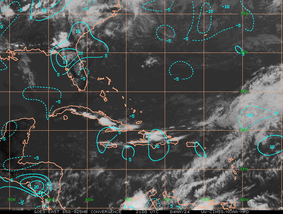
Upper Divergence
And if you have noticed, when a weak wave or trough moving westward enters the GOH it usally tightens up a bit.
AND NO I'M NOT SAYING THIS WILL develop, but something to watch. IF YOU WANT TO.
850mb Vorticity
Low Level convergence
Upper Divergence
And if you have noticed, when a weak wave or trough moving westward enters the GOH it usally tightens up a bit.
AND NO I'M NOT SAYING THIS WILL develop, but something to watch. IF YOU WANT TO.
0 likes
Re: Area of disturbed weather in the Caribbean
Pressure dropped a bit lately but still high, I think we will see a weak circulation tommorow before it enters the Yuctan. Maybe an invest in 24 hrs.?
http://www.ndbc.noaa.gov/station_page.php?station=42057
http://www.ndbc.noaa.gov/station_page.php?station=42057
0 likes
-
lrak

- S2K Supporter

- Posts: 1770
- Age: 59
- Joined: Thu Jun 21, 2007 2:48 pm
- Location: Corpus Christi, TX
Re: Area of disturbed weather in the Caribbean
tailgater wrote:Pressure dropped a bit lately but still high, I think we will see a weak circulation tommorow before it enters the Yuctan. Maybe an invest in 24 hrs.?
http://www.ndbc.noaa.gov/station_page.php?station=42057
Possible invest in the BOC 24hrs? Historically we don't get hurricanes this early but man S. Tex sure could use a tropical wave or depression. We're dryer than Dr. McCoy himself!

0 likes
-
gigabite

- S2K Supporter
- Posts: 916
- Age: 72
- Joined: Wed May 05, 2004 4:09 pm
- Location: Naples, Florida
Re: Area of disturbed weather in the Caribbean
It looks like that area of high pressure over the gulf is going to move off to the northeast gulf by Wednesday. That cloud mass could get spun up by the next passing front.
Agnes 1972
Agnes 1972
0 likes
Re: Area of disturbed weather in the Caribbean
Absolutely not, steerings will stay the same through the week, head westward into MX, even it it makes into the BOC.
0 likes
-
Ed Mahmoud
Re: Area of disturbed weather in the Caribbean
Dr. Jeff at Wunderground has chosen this time for his Greek vacation. Second half of June since warm AMO started about 15 years ago averages under a 30% chance of a TC (29%, IIRC), none of which has become a hurricane. Based on unfavorable dual jet structure, and no identifiable features, Dr. Jeff is 20% on any Atlantic TC action the second half of the month.
I'll go watch the JB video and report back, but I'm leaning toward Wunderground and away from AccuWx.
....
Joe not backing off second half June Central/Western GOMEX, but nothing seems to indicate that now.
I'll go watch the JB video and report back, but I'm leaning toward Wunderground and away from AccuWx.
....
Joe not backing off second half June Central/Western GOMEX, but nothing seems to indicate that now.
0 likes
-
wxman57

- Moderator-Pro Met

- Posts: 23122
- Age: 68
- Joined: Sat Jun 21, 2003 8:06 pm
- Location: Houston, TX (southwest)
Re: Area of disturbed weather in the Caribbean
NDG wrote:Absolutely not, steerings will stay the same through the week, head westward into MX, even it it makes into the BOC.
Right, steering will remain east to wast through the region. That ridge over the northern Gulf isn't budging this week. There's actually a weak upper ridge over the western Caribbean today, but it's progged to move west over the Yucatan tomorrow then across the BoC Wed/Thu before moving into southern MX for good. Convection remains disorganized (there is no "blob") and pressures remain on the high side through the Caribbean. Without any feature to focus the convection, it should continue drifting westward across the Yucatan tomorrow/tomorrow night then across the southern BoC Wed/Thu before moving into Mexico. Development chances remain low, perhaps 5%, which is about typical for this time of year.
0 likes
-
lrak
- S2K Supporter
- Posts: 1770
- Age: 59
- Joined: Thu Jun 21, 2007 2:48 pm
- Location: Corpus Christi, TX
Re: Area of disturbed weather in the Caribbean
http://www.lajollasurf.org/images/caanim.gif
Is this wave model too aggressive for anyone? If no rain then I'll take the swell
Is this wave model too aggressive for anyone? If no rain then I'll take the swell
0 likes


-
wxman57
- Moderator-Pro Met
- Posts: 23122
- Age: 68
- Joined: Sat Jun 21, 2003 8:06 pm
- Location: Houston, TX (southwest)
Re: Area of disturbed weather in the Caribbean
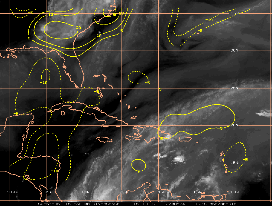
Here's a 12Z analysis of the Caribbean with satellite. In the east, pressures are quite high across the NE Caribbean (1015-1017mb). Just scattered storms. Pressures are also relatively high across the western Caribbean in and near those scattered storms approaching the Yucatan. There's no rotation and no organization. These thunderstorms will all move inland by tonight. Could pop up in the southern BoC tomorrow/Thursday, but development chances are minimal at best.

0 likes
-
wxman57
- Moderator-Pro Met
- Posts: 23122
- Age: 68
- Joined: Sat Jun 21, 2003 8:06 pm
- Location: Houston, TX (southwest)
Re: Area of disturbed weather in the Caribbean
In making a screenshot of the western Caribbean/Yucatan area, I noticed some highly questionable obs (in red boxes). One of the reports, a pressure of 990.7 mb is from a ship. The other, a quite high pressure of 1021.0 mb is from another ship docked at Grand Cayman Island. Clearly, neither report is correct. Just goes to show you to be VERY WARY of ship reports. They are sometimes carrying equipment that is very poorly calibrated:

0 likes
Re: Area of disturbed weather in the Caribbean
Black IR is always a clue in tropical energy. This wave burst deeply a week ago but then retrograded east with the trough and weakened. It kept a very weak 'blob' as an ill-defined center and has now separated from the trough into a weakly concentrated wave like feature. Still too weak to form, but offering a curling appearance to mimic formation. Should break down over Yucatan.
0 likes
Who is online
Users browsing this forum: wwizard and 62 guests