Here we go with this new invest.Discuss here all about it.
BEGIN
NHC_ATCF
invest_al932009.invest
FSTDA
R
U
040
010
0000
200906261204
NONE
NOTIFY=ATRP
END
INVEST, AL, L, , , , , 93, 2009, DB, O, 2009062612, 9999999999, , , , , , METWATCH, , AL932009
AL, 93, 2009062512, , BEST, 0, 141N, 819W, 20, 1009, DB, 0, , 0, 0, 0, 0,
AL, 93, 2009062518, , BEST, 0, 148N, 823W, 20, 1009, DB, 0, , 0, 0, 0, 0,
AL, 93, 2009062600, , BEST, 0, 155N, 827W, 20, 1009, DB, 0, , 0, 0, 0, 0,
AL, 93, 2009062606, , BEST, 0, 162N, 832W, 20, 1009, DB, 0, , 0, 0, 0, 0,
AL, 93, 2009062612, , BEST, 0, 167N, 837W, 20, 1008, DB,
ftp://ftp.tpc.ncep.noaa.gov/atcf/tcweb/
ATL : INVEST 93L
Moderator: S2k Moderators
-
cycloneye

- Admin

- Posts: 149727
- Age: 69
- Joined: Thu Oct 10, 2002 10:54 am
- Location: San Juan, Puerto Rico
ATL : INVEST 93L
0 likes
-
cycloneye
- Admin
- Posts: 149727
- Age: 69
- Joined: Thu Oct 10, 2002 10:54 am
- Location: San Juan, Puerto Rico
ATL : MODELS : INVEST 93L
All model runs will be posted in this thread.
WHXX01 KWBC 261213
CHGHUR
TROPICAL CYCLONE GUIDANCE MESSAGE
NWS TPC/NATIONAL HURRICANE CENTER MIAMI FL
1213 UTC FRI JUN 26 2009
DISCLAIMER...NUMERICAL MODELS ARE SUBJECT TO LARGE ERRORS.
PLEASE REFER TO NHC OFFICIAL FORECASTS FOR TROPICAL CYCLONE
AND SUBTROPICAL CYCLONE INFORMATION.
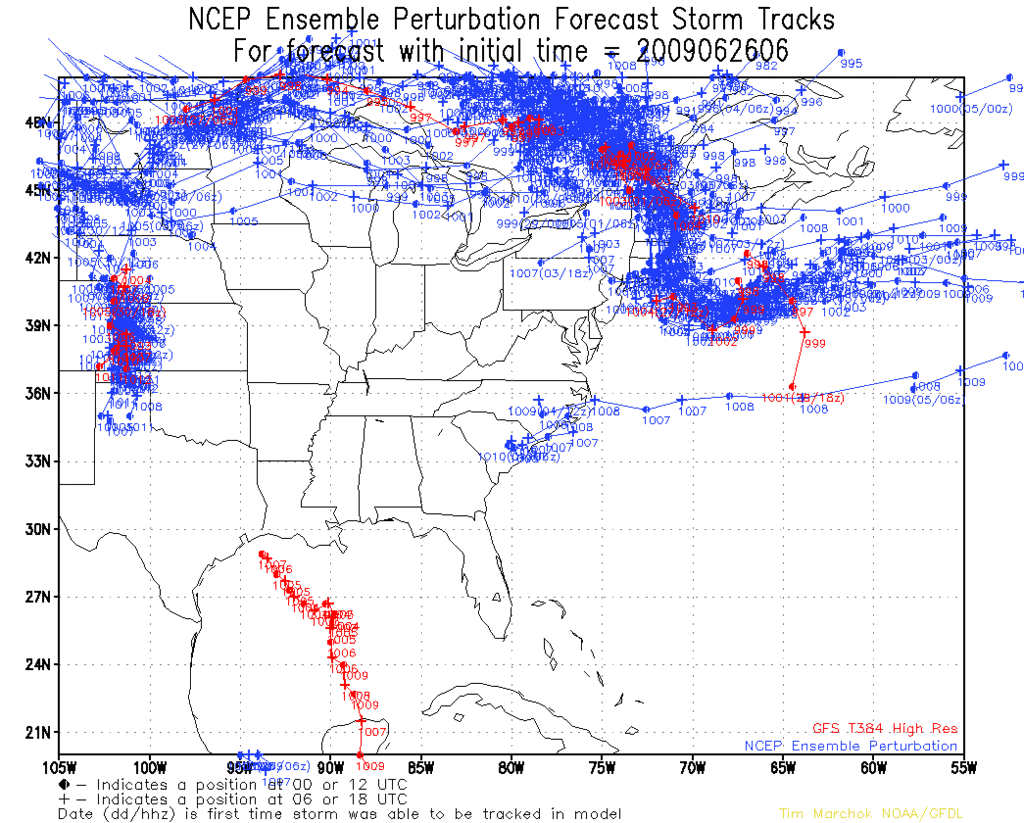
ATLANTIC OBJECTIVE AIDS FOR
DISTURBANCE INVEST (AL932009) 20090626 1200 UTC
...00 HRS... ...12 HRS... ...24 HRS. .. ...36 HRS...
090626 1200 090627 0000 090627 1200 090628 0000
LAT LON LAT LON LAT LON LAT LON
BAMS 16.7N 83.7W 18.2N 85.7W 19.7N 87.5W 21.0N 88.7W
BAMD 16.7N 83.7W 18.8N 85.2W 20.9N 86.6W 22.6N 87.9W
BAMM 16.7N 83.7W 18.6N 85.6W 20.3N 87.2W 21.9N 88.5W
LBAR 16.7N 83.7W 18.4N 84.8W 20.3N 85.8W 22.1N 86.5W
SHIP 20KTS 22KTS 25KTS 30KTS
DSHP 20KTS 22KTS 25KTS 28KTS
...48 HRS... ...72 HRS... ...96 HRS. .. ..120 HRS...
090628 1200 090629 1200 090630 1200 090701 1200
LAT LON LAT LON LAT LON LAT LON
BAMS 22.2N 89.8W 23.9N 90.5W 24.8N 90.6W 25.4N 92.2W
BAMD 23.5N 89.2W 24.3N 90.7W 24.1N 91.0W 24.0N 91.5W
BAMM 23.0N 89.6W 24.0N 90.9W 24.0N 91.2W 23.9N 92.3W
LBAR 23.5N 86.6W 25.1N 84.8W 26.5N 81.2W 29.5N 75.1W
SHIP 35KTS 45KTS 52KTS 59KTS
DSHP 33KTS 44KTS 51KTS 58KTS
...INITIAL CONDITIONS...
LATCUR = 16.7N LONCUR = 83.7W DIRCUR = 325DEG SPDCUR = 8KT
LATM12 = 15.5N LONM12 = 82.7W DIRM12 = 328DEG SPDM12 = 8KT
LATM24 = 14.1N LONM24 = 81.9W
WNDCUR = 20KT RMAXWD = 75NM WNDM12 = 20KT
CENPRS = 1008MB OUTPRS = 1010MB OUTRAD = 150NM SDEPTH = M
RD34NE = 0NM RD34SE = 0NM RD34SW = 0NM RD34NW = 0NM

WHXX01 KWBC 261213
CHGHUR
TROPICAL CYCLONE GUIDANCE MESSAGE
NWS TPC/NATIONAL HURRICANE CENTER MIAMI FL
1213 UTC FRI JUN 26 2009
DISCLAIMER...NUMERICAL MODELS ARE SUBJECT TO LARGE ERRORS.
PLEASE REFER TO NHC OFFICIAL FORECASTS FOR TROPICAL CYCLONE
AND SUBTROPICAL CYCLONE INFORMATION.
ATLANTIC OBJECTIVE AIDS FOR
DISTURBANCE INVEST (AL932009) 20090626 1200 UTC
...00 HRS... ...12 HRS... ...24 HRS. .. ...36 HRS...
090626 1200 090627 0000 090627 1200 090628 0000
LAT LON LAT LON LAT LON LAT LON
BAMS 16.7N 83.7W 18.2N 85.7W 19.7N 87.5W 21.0N 88.7W
BAMD 16.7N 83.7W 18.8N 85.2W 20.9N 86.6W 22.6N 87.9W
BAMM 16.7N 83.7W 18.6N 85.6W 20.3N 87.2W 21.9N 88.5W
LBAR 16.7N 83.7W 18.4N 84.8W 20.3N 85.8W 22.1N 86.5W
SHIP 20KTS 22KTS 25KTS 30KTS
DSHP 20KTS 22KTS 25KTS 28KTS
...48 HRS... ...72 HRS... ...96 HRS. .. ..120 HRS...
090628 1200 090629 1200 090630 1200 090701 1200
LAT LON LAT LON LAT LON LAT LON
BAMS 22.2N 89.8W 23.9N 90.5W 24.8N 90.6W 25.4N 92.2W
BAMD 23.5N 89.2W 24.3N 90.7W 24.1N 91.0W 24.0N 91.5W
BAMM 23.0N 89.6W 24.0N 90.9W 24.0N 91.2W 23.9N 92.3W
LBAR 23.5N 86.6W 25.1N 84.8W 26.5N 81.2W 29.5N 75.1W
SHIP 35KTS 45KTS 52KTS 59KTS
DSHP 33KTS 44KTS 51KTS 58KTS
...INITIAL CONDITIONS...
LATCUR = 16.7N LONCUR = 83.7W DIRCUR = 325DEG SPDCUR = 8KT
LATM12 = 15.5N LONM12 = 82.7W DIRM12 = 328DEG SPDM12 = 8KT
LATM24 = 14.1N LONM24 = 81.9W
WNDCUR = 20KT RMAXWD = 75NM WNDM12 = 20KT
CENPRS = 1008MB OUTPRS = 1010MB OUTRAD = 150NM SDEPTH = M
RD34NE = 0NM RD34SE = 0NM RD34SW = 0NM RD34NW = 0NM
0 likes

Re: ATL : Invest 93L
I glad it's just 1 thread now But I'm a little surprised by the Invest this early. I don;t see anything at the surface yet.
0 likes
-
cycloneye
- Admin
- Posts: 149727
- Age: 69
- Joined: Thu Oct 10, 2002 10:54 am
- Location: San Juan, Puerto Rico
Re: ATL : Invest 93L
tailgater wrote:I glad it's just 1 thread now But I'm a little surprised by the Invest this early. I don;t see anything at the surface yet.
As you can see in the first post,they haved been ploting positions since yesterday morning at 12 UTC.
0 likes

Re: ATL : INVEST 93L
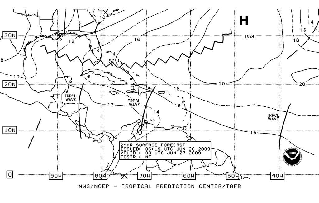
There appears to be a twist in that area ATTM (perhaps a MLC):
http://www.goes.noaa.gov/HURRLOOPS/huirloop.html
http://www.goes.noaa.gov/HURRLOOPS/huirloop.html
0 likes
-
Derek Ortt
-
Ed Mahmoud
Re: ATL : INVEST 93L
The Joe Bastardi thread has been locked.
Well, even if nothing develops, his identifying a likely period of upward motion in the Western Caribbean and Gulf from 2 months out is impressive. I think.
Only ointment in that fly, I'm not sure this ever crosses 90ºW in the Gulf, which would make it an Eastern Gulf system, even if it does develop.
And June produces 5%, per TWC, on average, of annual named storms during the season, so a June prediction is not a sure shot.
0 likes
-
srainhoutx

- S2K Supporter

- Posts: 6919
- Age: 68
- Joined: Sun Jan 14, 2007 11:34 am
- Location: Haywood County, NC
- Contact:
-
wxman57

- Moderator-Pro Met

- Posts: 23175
- Age: 68
- Joined: Sat Jun 21, 2003 8:06 pm
- Location: Houston, TX (southwest)
Re: ATL : INVEST 93L
What we're seeing now is a tropical wave interacting with an upper trof/low. Convection is well-removed from the wave axis (off to the east). Surface obs indicate pressures relatively high (at least not very low) in the area. And there is no evidence of a low center at the surface. Over the past few hours, convection has been weakening (tops warming) and its becoming more separated from the wave axis.
What we have to watch for is persistent concentrated convection over the same area (for 24 hours or so). If this happens, then it could generate a surface low and lead to development. Chances of that happening appear to be less than 50% this morning, but quantifying chances with an exact number is quite difficult.
One thing I am confident about - if it does persist, develop the surface low, and become a TD/TS as it moves into the southern Gulf late this weekend, then I don't see anything to prevent continued development to a hurricane. Upper level winds across the mid Gulf are forecast to be quite favorable for development. Heat content isn't great yet, but a Cat 3 hurricane could easily be supported.
As for a threat area, the ridge over TX is forecast to weaken some by early next week. That could mean a landfall anywhere between Tampico and Mississippi, depending on if, when, where this develops.
Hey! I forgot to tell tropics that I had canceled my vacation day for today! Things always go nuts if I schedule a vacation day.
0 likes

Re: ATL : INVEST 93L
[quote="Ed Mahmoud"]The Joe Bastardi thread has been locked.
Well, even if nothing develops, his identifying a likely period of upward motion in the Western Caribbean and Gulf from 2 months out is impressive. I think.
Only ointment in that fly, I'm not sure this ever crosses 90ºW in the Gulf, which would make it an Eastern Gulf system, even if it does develop.
And June produces 5%, per TWC, on average, of annual named storms during the season, so a June prediction is not a sure shot.[/quote]
But most of the models trend west Ed...IMO, it something were to develope it would be a WGOMEX storm and with any luck it would remain a minimal wind maker but bring lots and lots of rain to the drought stricken areas of Texas that are in dire need of precip
0 likes
-
srainhoutx
- S2K Supporter
- Posts: 6919
- Age: 68
- Joined: Sun Jan 14, 2007 11:34 am
- Location: Haywood County, NC
- Contact:
Re: ATL : INVEST 93L
wxman57 wrote:What we're seeing now is a tropical wave interacting with an upper trof/low. Convection is well-removed from the wave axis (off to the east). Surface obs indicate pressures relatively high (at least not very low) in the area. And there is no evidence of a low center at the surface. Over the past few hours, convection has been weakening (tops warming) and its becoming more separated from the wave axis.
What we have to watch for is persistent concentrated convection over the same area (for 24 hours or so). If this happens, then it could generate a surface low and lead to development. Chances of that happening appear to be less than 50% this morning, but quantifying chances with an exact number is quite difficult.
One thing I am confident about - if it does persist, develop the surface low, and become a TD/TS as it moves into the southern Gulf late this weekend, then I don't see anything to prevent continued development to a hurricane. Upper level winds across the mid Gulf are forecast to be quite favorable for development. Heat content isn't great yet, but a Cat 3 hurricane could easily be supported.
As for a threat area, the ridge over TX is forecast to weaken some by early next week. That could mean a landfall anywhere between Tampico and Mississippi, depending on if, when, where this develops.
Hey! I forgot to tell tropics that I had canceled my vacation day for today! Things always go nuts if I schedule a vacation day.
I just knew you had scheduled time off.
0 likes
-
PTrackerLA

- Category 5

- Posts: 5281
- Age: 42
- Joined: Thu Oct 10, 2002 8:40 pm
- Location: Lafayette, LA
Re: ATL : INVEST 93L
I see nothing where the low is plotted but the Grand Cayman convection looks suspicious. Let's see if it persists throughout the day. We need a floater!
Hopefully whatever comes of this can enhance our rain chances next week or at least initiate a pattern change to more typical showers/storms around here. If we don't get any help from the tropics we are well on our way to a severe drought.
Hopefully whatever comes of this can enhance our rain chances next week or at least initiate a pattern change to more typical showers/storms around here. If we don't get any help from the tropics we are well on our way to a severe drought.
0 likes
-
srainhoutx
- S2K Supporter
- Posts: 6919
- Age: 68
- Joined: Sun Jan 14, 2007 11:34 am
- Location: Haywood County, NC
- Contact:

Re: ATL : INVEST 93L
I see the possible MLC too, but if convection doesn't persist it won't have any chance. If convetion persist then we will have to wait until it reaches the GOM because in the Caribbean conditions are hostile, and I agree that once it reaches the GOM conditions will be favorable for development.
0 likes
-
wxman57
- Moderator-Pro Met
- Posts: 23175
- Age: 68
- Joined: Sat Jun 21, 2003 8:06 pm
- Location: Houston, TX (southwest)
Re: ATL : INVEST 93L
Not much time, but here's a sfc plot with satellite. The red crosshair is the NHC position. Note that the convection is about 200 miles northeast of this point and moving away from the invest center. Also note that pressures increase to the northeast of the invest center - across the Caymans and Cuba. So there's certainly no lower pressure near the convection. Hopefully, the convection will continue to separate from the center and eventually dissipate;

0 likes

-
cycloneye
- Admin
- Posts: 149727
- Age: 69
- Joined: Thu Oct 10, 2002 10:54 am
- Location: San Juan, Puerto Rico
Re: ATL : INVEST 93L
Recon for sunday afternoon (If Necessary)
000
NOUS42 KNHC 261300
WEATHER RECONNAISSANCE FLIGHTS
CARCAH, NATIONAL HURRICANE CENTER, MIAMI, FL.
0900 AM EDT FRI 26 JUNE 2009
SUBJECT: TROPICAL CYCLONE PLAN OF THE DAY (TCPOD)
VALID 27/1100Z TO 28/1100Z JUNE 2009
TCPOD NUMBER.....09-029
I. ATLANTIC REQUIREMENTS
1. NEGATIVE RECONNAISSANCE REQUIREMENTS.
2. OUTLOOK FOR SUCCEEDING DAY; POSSIBLE LOW LEVEL
INVEST NEAR 23N 90W AT 28/1800Z.
0 likes
Who is online
Users browsing this forum: No registered users and 44 guests