ATL : INVEST 93L
Moderator: S2k Moderators
- srainhoutx
- S2K Supporter

- Posts: 6919
- Age: 68
- Joined: Sun Jan 14, 2007 11:34 am
- Location: Haywood County, NC
- Contact:
-
OuterBanker
- S2K Supporter

- Posts: 1761
- Joined: Wed Feb 26, 2003 10:53 am
- Location: Nags Head, NC
- Contact:
Wow, what a beautiful blob. This season I have a feeling we will grasping at all blobs. It will truly be an off year. Between the SOI and El Nino I think that the Cape Verde season will be non existant. The 1915z blob is symmetric with deep convection, a thing of beauty. Of course it could go poof too. Anyway it is something to watch.
0 likes
- southerngale
- Retired Staff

- Posts: 27418
- Joined: Thu Oct 10, 2002 1:27 am
- Location: Southeast Texas (Beaumont area)
It was headed for Texas this morning and now it's Florida... the season has officially begun!
If you're on Twitter, follow Storm2k for brief updates.
https://twitter.com/storm2k_org
If you're on Twitter, follow Storm2k for brief updates.
https://twitter.com/storm2k_org
0 likes
-
OuterBanker
- S2K Supporter

- Posts: 1761
- Joined: Wed Feb 26, 2003 10:53 am
- Location: Nags Head, NC
- Contact:
-
caneman
Re: ATL : INVEST 93L
That ULL is moving SW. In my experience this is classic example of storms coming thru this time of year that this will actually aid in development. Give it another day or two.
0 likes
- AdamFirst
- S2K Supporter

- Posts: 2490
- Age: 36
- Joined: Thu Aug 14, 2008 10:54 am
- Location: Port Saint Lucie, FL
Re:
OuterBanker wrote:OK, why south Fla, Are they expecting the trough split to pick it up? I thought this would be a Yucatan to Tx deal.
The high pressure ridge "of death" over the gulf is standing pat...it would pretty much force it to go north/northeast. That is, if it's still there at the time.
(I'm not a professional, this is just my opinion, yadda yadda yadda)
0 likes
-
Ed Mahmoud
Re:
OuterBanker wrote:Wow, what a beautiful blob. This season I have a feeling we will grasping at all blobs. It will truly be an off year. Between the SOI and El Nino I think that the Cape Verde season will be non existant. The 1915z blob is symmetric with deep convection, a thing of beauty. Of course it could go poof too. Anyway it is something to watch.
My SSD flash loop pops a map of the Philippines into one frame, so I had to turn that off, but it is a thing of beauty.
I suspect poofation as well, and if it doesn't poof, it probably goes to Florida, but my lawn would so love a 40 mph dropping 5 inches of rain and leaving by July 4th storm.
0 likes
- cheezyWXguy
- Category 5

- Posts: 6282
- Joined: Mon Feb 13, 2006 12:29 am
- Location: Dallas, TX
Re: ATL : INVEST 93L
Stormcenter wrote:A hurricane....hmmmmm I don't know about that.cheezyWXguy wrote:Sanibel wrote:Disclaimer: Internet weenie opinion and not official:
Good point about weaker disturbances surviving Yucatan better that stronger ones.
Seeing the better mid-level convergence I'd gamble with development at this point from past behavior of similar disturbances. The only question will be if it is one of those broad GOM June TS's or something tighter. Still, the wise forecaster waits and sees.
If/Once it develops, there's not a whole lot seen at this point that could really slow it down from becoming a hurricane, unless it continues to drift west, bringing it to slightly cooler water temps, and less time over water. Other than that, especially if it goes NE, then I think its possible-assuming it develops at all-to ramp up in strength and possibly become a hurricane. Much too early at this point tho
According to ships, its a possibility. Conditions aren't all that bad right now, so if some sort of llc gets started, i suppose its possible
0 likes
- PTrackerLA
- Category 5

- Posts: 5281
- Age: 42
- Joined: Thu Oct 10, 2002 8:40 pm
- Location: Lafayette, LA
Re: ATL : INVEST 93L
Not so sure a "poof" is imminent. Visible sat shows lots of convergence and continued development of deep convection. Notice the low level clouds streaming into the convection from the SE and SW sides.
0 likes
Re: ATL : INVEST 93L
I wouldn't be surprised if we get a temporary poof in the sense that convectin will die down at some point, but I think that the environment is becoming increasingly favorable, and If I had to put my money on it, I would say that yes, this becomes classified by this weekend.
0 likes
-
Brent
- S2K Supporter

- Posts: 38777
- Age: 37
- Joined: Sun May 16, 2004 10:30 pm
- Location: Tulsa Oklahoma
- Contact:
Re: ATL : INVEST 93L
WOW, huge and very nice blowup of convection. Looks pretty good this afternoon. I really think this is going to be named.
0 likes
Re: ATL : INVEST 93L
likely an outflow boundary is about to hit this buoy....pressure dropped 3MB in one hour and winds turned parallel with front of outflow boundary...next hour will tell the tale...
http://www.ndbc.noaa.gov/station_page.p ... t=M&tz=STN
http://www.ndbc.noaa.gov/station_page.p ... t=M&tz=STN
0 likes
- cycloneye
- Admin

- Posts: 149727
- Age: 69
- Joined: Thu Oct 10, 2002 10:54 am
- Location: San Juan, Puerto Rico
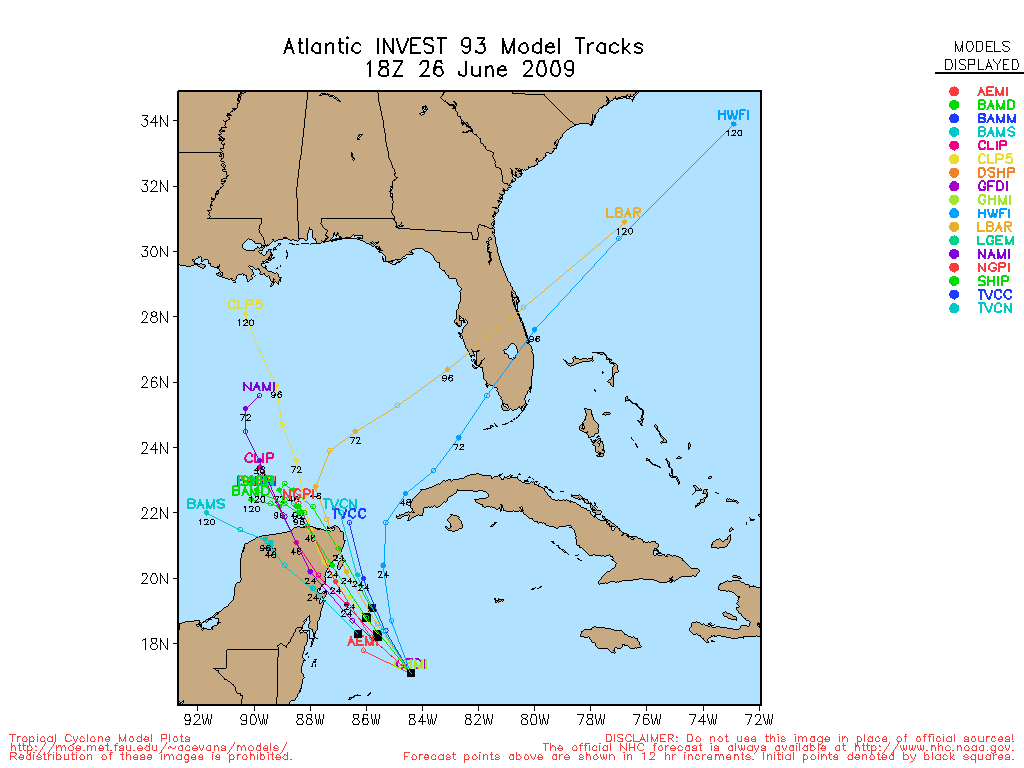
Re: ATL : MODELS : INVEST 93L
The 18z GFS is more agressive in intensity.I will post the different timeframes in this post.
48 hours
http://www.nco.ncep.noaa.gov/pmb/nwprod ... n_048l.gif
72 hours=Tropical Storm
http://www.nco.ncep.noaa.gov/pmb/nwprod ... n_072l.gif
78 hours=Tropical Storm
http://www.nco.ncep.noaa.gov/pmb/nwprod ... n_078l.gif
96 hours=Going to Florida Penninsula.
http://www.nco.ncep.noaa.gov/pmb/nwprod ... n_096l.gif
102 hours
http://www.nco.ncep.noaa.gov/pmb/nwprod ... n_102l.gif
114 hours=Landfall north of Tampa.
http://www.nco.ncep.noaa.gov/pmb/nwprod ... n_114l.gif
120 hours=On Georgias coast.
http://www.nco.ncep.noaa.gov/pmb/nwprod ... n_120l.gif
Loop of the 18z GFS run.
http://www.nco.ncep.noaa.gov/pmb/nwprod ... loop.shtml
There you have it.Comments about this run?
0 likes
Re: ATL : MODELS : INVEST 93L
cycloneye wrote:
There you have it.Comments about this run?
Go away, we have had enough rain.
0 likes
-
Aric Dunn
- Category 5

- Posts: 21238
- Age: 43
- Joined: Sun Sep 19, 2004 9:58 pm
- Location: Ready for the Chase.
- Contact:
hello .. all
who's excited.. hehe
would say that everything is going for the system at the moment, except for land over the next 24 to 36 hours. right now though there is a large area of concentrated convection but barely any surface reflection. But with such an area of convection and clearly a strong SE inflow and relatively weak inflow on the SW and west side of the convection, there seems to be a increased chance of development before the Yucatan. If the flow through the system was strong from SE then I would say this was no where near any development. but observations show weakening wind field and more convergence over the gulf of Honduras today which would suggest at least a higher chance of development.
one thing must happen and that is, this convection need to persist over night !! if that happens we could wake up to a surface low developing...
0 likes
- cycloneye
- Admin

- Posts: 149727
- Age: 69
- Joined: Thu Oct 10, 2002 10:54 am
- Location: San Juan, Puerto Rico
Re:
Aric Dunn wrote:hello .. all
who's excited.. hehe
would say that everything is going for the system at the moment, except for land over the next 24 to 36 hours. right now though there is a large area of concentrated convection but barely any surface reflection. But with such an area of convection and clearly a strong SE inflow and relatively weak inflow on the SW and west side of the convection, there seems to be a increased chance of development before the Yucatan. If the flow through the system was strong from SE then I would say this was no where near any development. but observations show weakening wind field and more convergence over the gulf of Honduras today which would suggest at least a higher chance of development.
one thing must happen and that is, this convection need to persist over night !! if that happens we could wake up to a surface low developing...
Welcome back my friend.Are you ready to rumble on this?
0 likes
-
Aric Dunn
- Category 5

- Posts: 21238
- Age: 43
- Joined: Sun Sep 19, 2004 9:58 pm
- Location: Ready for the Chase.
- Contact:
Re: Re:
cycloneye wrote:Aric Dunn wrote:hello .. all
who's excited.. hehe
would say that everything is going for the system at the moment, except for land over the next 24 to 36 hours. right now though there is a large area of concentrated convection but barely any surface reflection. But with such an area of convection and clearly a strong SE inflow and relatively weak inflow on the SW and west side of the convection, there seems to be a increased chance of development before the Yucatan. If the flow through the system was strong from SE then I would say this was no where near any development. but observations show weakening wind field and more convergence over the gulf of Honduras today which would suggest at least a higher chance of development.
one thing must happen and that is, this convection need to persist over night !! if that happens we could wake up to a surface low developing...
Welcome back my friend.Are you ready to rumble on this?
oh yes!!!..
was on a vacation/physics seminar for the last 3 weeks
this one has some potential
0 likes
-
Aric Dunn
- Category 5

- Posts: 21238
- Age: 43
- Joined: Sun Sep 19, 2004 9:58 pm
- Location: Ready for the Chase.
- Contact:
Re: ATL : INVEST 93L
drezee wrote:likely an outflow boundary is about to hit this buoy....pressure dropped 3MB in one hour and winds turned parallel with front of outflow boundary...next hour will tell the tale...
http://www.ndbc.noaa.gov/station_page.p ... t=M&tz=STN
that is a huge pressure drop !! for a outflow boundary .. i wonder if its a bad reading ..
0 likes
Who is online
Users browsing this forum: No registered users and 29 guests


