ATL : INVEST 93L
Moderator: S2k Moderators
-
Evil Jeremy

- S2K Supporter

- Posts: 5463
- Age: 32
- Joined: Mon Apr 10, 2006 2:10 pm
- Location: Los Angeles, CA
Re: ATL : INVEST 93L
Despite all the shear, you can tell that 93L is really trying to do something at this point. It is really fighting the shear: http://www.ssd.noaa.gov/goes/east/gmex/loop-vis.html
0 likes
-
HouTXmetro

- Category 5

- Posts: 3949
- Joined: Sun Jun 13, 2004 6:00 pm
- Location: District of Columbia, USA
Re: ATL : MODELS : INVEST 93L
LOL, whats the TCVN model? Needless to say there in nothing to develop. However it something does develop the models are not in agreement.
0 likes


Re: ATL : INVEST 93L
Perhaps, but the old rule of thumb says that when a system gets completely sheared it might regenerate, but even if it does it will not regain it's original organization - that seems to always be true...
P.S. Last evening some dumb cluck on TWC or elsewhere said that perhaps it might travel around the high to it's east and head towards Florida as a tropical storm - it made me think of my evacuation plan, for the first time this season...
Thoughts like that are about as much fun as having the hives....
0 likes
-
senorpepr

- Military Met/Moderator

- Posts: 12542
- Age: 43
- Joined: Fri Aug 22, 2003 9:22 pm
- Location: Mackenbach, Germany
- Contact:
146
NOUS42 KNHC 281600
WEATHER RECONNAISSANCE FLIGHTS
CARCAH, NATIONAL HURRICANE CENTER, MIAMI, FL.
1200 PM EDT SUN 28 JUNE 2009
SUBJECT: TROPICAL CYCLONE PLAN OF THE DAY (TCPOD)
VALID 29/1100Z TO 30/1100Z JUNE 2009
TCPOD NUMBER.....09-031
I. ATLANTIC REQUIREMENTS
1. SUSPECT AREA -- GULF OF MEXICO
FLLGHT ONE -- TEAL 70
A. 29/1800Z
B. AFXXX 01AAA INVEST
C. 29/1600Z
D. 23.0N 90.0W
E. 29/1700Z TO 30/0000Z
F. SFC TO 10,000 FT
2. OUTLOOK FOR SUCCEEDING DAY: BRGIN 12 HRLY FIXES
AT 30/1500Z IF SYSTEM DEVELOPS.
II. PACIFIC REQUIREMENTS
1. NEGATIVE RECONNAISSANCE REQUIREMENTS.
2. OUTLOOK FOR SUCCEDING DAY.....NEGATIVE.
WVW
0 likes

Re: ATL : INVEST 93L
Evil Jeremy wrote:Despite all the shear, you can tell that 93L is really trying to do something at this point. It is really fighting the shear: http://www.ssd.noaa.gov/goes/east/gmex/loop-vis.html
Yes, looking the SAT loops it seems it has more low level structure this morning but lots of shear right now, I guess conditions aren't so great in GOM.
I see some weak convection trying to wrap around the Naked swirl just north of the Yucatan but 5% sounds good to me.
0 likes

Re: ATL : INVEST 93L
Maybe the NAM was on to something....this is flowing that ULL into the WGOM. Let it clear the Yuc and sit in the BOC for awhile. Nice warm water down there....
0 likes
-
senorpepr
- Military Met/Moderator
- Posts: 12542
- Age: 43
- Joined: Fri Aug 22, 2003 9:22 pm
- Location: Mackenbach, Germany
- Contact:
A correction...
361
NOUS42 KNHC 281600 COR
WEATHER RECONNAISSANCE FLIGHTS
CARCAH, NATIONAL HURRICANE CENTER, MIAMI, FL.
1200 PM EDT SUN 28 JUNE 2009
SUBJECT: TROPICAL CYCLONE PLAN OF THE DAY (TCPOD)
VALID 29/1100Z TO 30/1100Z JUNE 2009
TCPOD NUMBER.....09-031 CORRECTION
I. ATLANTIC REQUIREMENTS -- NO CHANGE
1. SUSPECT AREA -- GULF OF MEXICO
FLLGHT ONE -- TEAL 70
A. 29/1800Z
B. AFXXX 01AAA INVEST
C. 29/1600Z
D. 23.0N 90.0W
E. 29/1700Z TO 30/0000Z
F. SFC TO 10,000 FT
2. OUTLOOK FOR SUCCEEDING DAY: BRGIN 12 HRLY FIXES
AT 30/1500Z IF SYSTEM DEVELOPS.
3. NOTE: THE MISSIONS TASKED FOR 28/18 AND 29/06Z
WERE CANX BY NHC AT 28/1200Z. -- ADDED --
II. PACIFIC REQUIREMENTS
1. NEGATIVE RECONNAISSANCE REQUIREMENTS.
2. OUTLOOK FOR SUCCEDING DAY.....NEGATIVE.
WVW
0 likes
-
senorpepr
- Military Met/Moderator
- Posts: 12542
- Age: 43
- Joined: Fri Aug 22, 2003 9:22 pm
- Location: Mackenbach, Germany
- Contact:
Re:
Derek Ortt wrote:12 hourly fixes in the GOM? I thought 6 hourly were required for the GOM?
I was led to believe it was based on the threat and strength of the storm. I may be wrong, however...
0 likes
-
Bailey1777
- S2K Supporter
- Posts: 962
- Joined: Mon Jul 31, 2006 6:23 pm
- Location: Houston, Texas
-
HurricaneRobert
- Category 3

- Posts: 812
- Joined: Fri May 18, 2007 9:31 pm
-
HouTXmetro
- Category 5
- Posts: 3949
- Joined: Sun Jun 13, 2004 6:00 pm
- Location: District of Columbia, USA
Re: ATL : INVEST 93L
HurricaneRobert wrote:I was hoping that meant showers along the gulf coast.
I could be wrong but I think a frontal boundary should drape itself along the Gulf coast. The instability in addition to the Tropical Wave may provide fuel for some moisture along the Gulf.
0 likes
-
cycloneye

- Admin

- Posts: 149727
- Age: 69
- Joined: Thu Oct 10, 2002 10:54 am
- Location: San Juan, Puerto Rico
Re: ATL : INVEST 93L
035
ABNT20 KNHC 281738
TWOAT
TROPICAL WEATHER OUTLOOK
NWS TPC/NATIONAL HURRICANE CENTER MIAMI FL
200 PM EDT SUN JUN 28 2009
FOR THE NORTH ATLANTIC...CARIBBEAN SEA AND THE GULF OF MEXICO...
DISORGANIZED SHOWERS AND THUNDERSTORMS EXTEND FROM THE NORTHEASTERN
YUCATAN PENINSULA INTO THE SOUTHERN GULF OF MEXICO. DEVELOPMENT...
IF ANY...OF THIS SYSTEM IS EXPECTED TO BE SLOW TO OCCUR AS IT
DRIFTS NORTHWESTWARD OVER THE NEXT DAY OR TWO. THERE IS A LOW
CHANCE...LESS THAN 30 PERCENT...OF THIS SYSTEM BECOMING A
TROPICAL CYCLONE DURING THE NEXT 48 HOURS.
ELSEWHERE...TROPICAL CYCLONE FORMATION IS NOT EXPECTED DURING THE
NEXT 48 HOURS.
$$
FORECASTER PASCH/LANDSEA
0 likes
-
Tampa Bay Hurricane

- Category 5
- Posts: 5597
- Age: 38
- Joined: Fri Jul 22, 2005 7:54 pm
- Location: St. Petersburg, FL
The posts in this forum are NOT official forecast and should not be used as such. They are just the opinion of the poster and may or may not be backed by sound meteorological data. They are NOT endorsed by any professional institution or storm2k.org. For official information, please refer to the NHC and NWS products
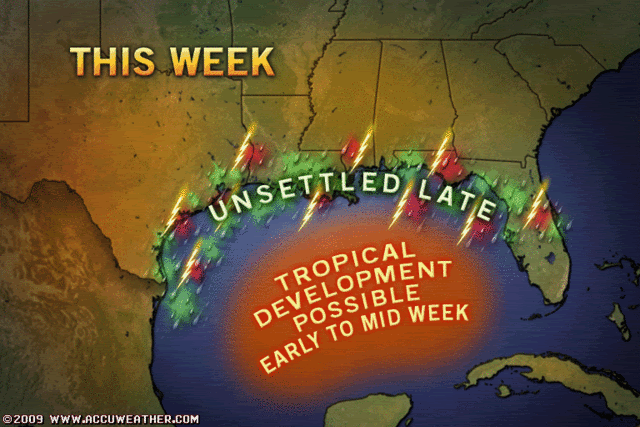
The actual tropical wave is moving west towards Texas...convection diffuse-
in other words their should be a large area of rain/moisture along the
gulf coast from Texas to Florida, regardless of development. Notice
the huge slug of moisture on the east side. Even if the wave goes
into Texas/Mexico, the whole gulf should have a lot more moisture to help
dry areas.
0 likes
-
srainhoutx

- S2K Supporter
- Posts: 6919
- Age: 68
- Joined: Sun Jan 14, 2007 11:34 am
- Location: Haywood County, NC
- Contact:
Re: ATL : INVEST 93L
ROCK wrote:Maybe the NAM was on to something....this is flowing that ULL into the WGOM. Let it clear the Yuc and sit in the BOC for awhile. Nice warm water down there....
I'll take the rain no matter how weak it is. Here's hoping and score one for the NAM.
0 likes
-
brunota2003

- S2K Supporter
- Posts: 9476
- Age: 35
- Joined: Sat Jul 30, 2005 9:56 pm
- Location: Stanton, KY...formerly Havelock, NC
- Contact:
Re: Re:
senorpepr wrote:Derek Ortt wrote:12 hourly fixes in the GOM? I thought 6 hourly were required for the GOM?
I was led to believe it was based on the threat and strength of the storm. I may be wrong, however...
Yeah...I think due to the fact it is only an invest at the moment (much less anything tropical), it'd be a waste to support recon aircraft flying around so much. What would they do? Look for people sail boating or wind surfing? "I found one! See if y'all can find him!!!"
Last edited by brunota2003 on Sun Jun 28, 2009 1:28 pm, edited 1 time in total.
0 likes

Who is online
Users browsing this forum: No registered users and 62 guests