ENSO Updates (2007 thru 2023)
Moderator: S2k Moderators
Forum rules
The posts in this forum are NOT official forecasts and should not be used as such. They are just the opinion of the poster and may or may not be backed by sound meteorological data. They are NOT endorsed by any professional institution or STORM2K. For official information, please refer to products from the National Hurricane Center and National Weather Service.
- Bocadude85
- Category 5

- Posts: 2991
- Age: 39
- Joined: Mon Apr 18, 2005 2:20 pm
- Location: Honolulu,Hi
Re: ENSO Updates
What does it mean when the SOI is positive? Is that good or bad for a developing El Nino?
0 likes
- cycloneye
- Admin

- Posts: 149156
- Age: 69
- Joined: Thu Oct 10, 2002 10:54 am
- Location: San Juan, Puerto Rico
Re: ENSO Updates
Bocadude85 wrote:What does it mean when the SOI is positive? Is that good or bad for a developing El Nino?
When the SOI climbs to positive it means no el nino,and when it turns negative,it means warmer ENSO is in the cards.What is occuring now about the SOI climbing,may mean a stall to the official declaration of the arrival of El Nino for now.
Below is a glossary with a complete scientific explanation about the SOI (Southern Occillation Index)
http://www.bom.gov.au/climate/glossary/soi.shtml
0 likes
- cycloneye
- Admin

- Posts: 149156
- Age: 69
- Joined: Thu Oct 10, 2002 10:54 am
- Location: San Juan, Puerto Rico
Re: ENSO Updates
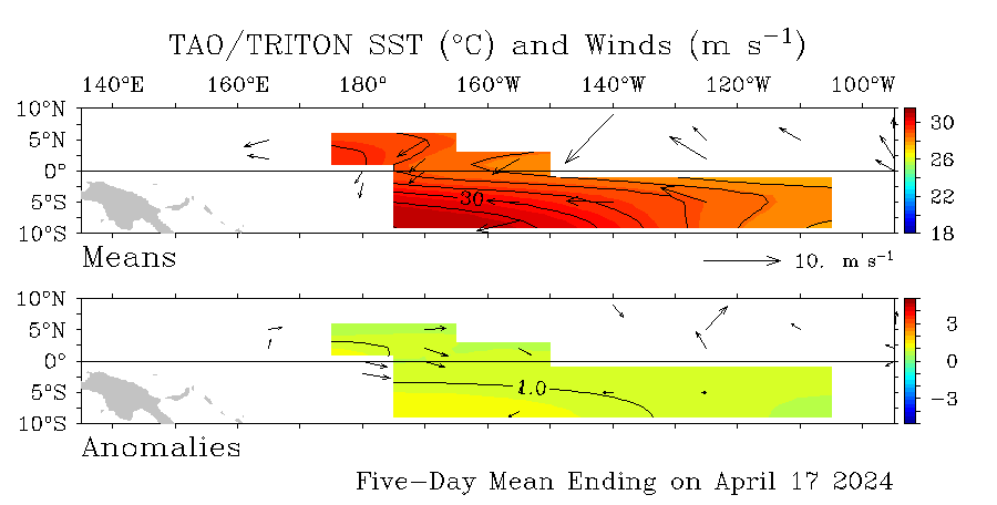
Daily data in graphic of Anomalies
No big changes from the past 2 weeks on those anomalies.Lets see what happens this week.This graphic updates everyday.
http://www.pmel.noaa.gov/tao/
No big changes from the past 2 weeks on those anomalies.Lets see what happens this week.This graphic updates everyday.

http://www.pmel.noaa.gov/tao/
0 likes
If anyone (Professional or otherwise) can answer this question, I would be greatly appreciative.
Obviously, El Nino causes a decline in Atlantic tropical activity because of increased wind shear. However, is this because of the warmer Pacific waters, or is it because of the negative SOI values? I ask this merely because the SOI fluctuation within a short period (say a month) is much greater than SST anomaly fluctuation. Therefore, could it be possible that during hurricane season during an El-Nino year, the few brief times when the SOI values are positive development is more likely to happen?
This may be totally off-the-wall, but if anyone could take a stab at this I'd greatly appreciate it.
0 likes
- cycloneye
- Admin

- Posts: 149156
- Age: 69
- Joined: Thu Oct 10, 2002 10:54 am
- Location: San Juan, Puerto Rico
Re: ENSO Updates
Daily SOI Index Data
It continues to climb,now at positive territory since June 22.
22-Jun-2009 +6.61
23-Jun-2009 +11.04
24-Jun-2009 +12.44
25-Jun-2009 +20.53
26-Jun-2009 +25.02
27-Jun-2009 +31.28
28-Jun-2009 +34.87
http://www.longpaddock.qld.gov.au/Seaso ... SOIValues/´
30 Day SOI Index Data
The 30 day SOI is following the daily data.

http://www.bom.gov.au/climate/enso/soi.dt3
BigA,that is a good question for the pro mets or anyone that knows how this works to chim in.
It continues to climb,now at positive territory since June 22.
22-Jun-2009 +6.61
23-Jun-2009 +11.04
24-Jun-2009 +12.44
25-Jun-2009 +20.53
26-Jun-2009 +25.02
27-Jun-2009 +31.28
28-Jun-2009 +34.87
http://www.longpaddock.qld.gov.au/Seaso ... SOIValues/´
30 Day SOI Index Data
The 30 day SOI is following the daily data.

http://www.bom.gov.au/climate/enso/soi.dt3
BigA,that is a good question for the pro mets or anyone that knows how this works to chim in.
0 likes
- cycloneye
- Admin

- Posts: 149156
- Age: 69
- Joined: Thu Oct 10, 2002 10:54 am
- Location: San Juan, Puerto Rico
Re: ENSO Updates
Comparisons between 1997 and 2009 by the end of June.
1997

2009

http://www.osdpd.noaa.gov/PSB/EPS/SST/climo.html
1997

2009

http://www.osdpd.noaa.gov/PSB/EPS/SST/climo.html
0 likes
- cycloneye
- Admin

- Posts: 149156
- Age: 69
- Joined: Thu Oct 10, 2002 10:54 am
- Location: San Juan, Puerto Rico
Re: ENSO Updates
6/29/09 Climate Prediction Center Weekly Update
The data that they have suggests that in the next 2-3 weeks,an official declaration of the arrival of El Nino will be released.
The latest weekly SST departures are:
Niño 4= 0.7ºC
Niño 3.4= 0.9ºC
Niño 3=1.0ºC
Niño1+2=0.8ºC
Read the latest weekly CPC update below.
http://www.cpc.ncep.noaa.gov/products/a ... ts-web.pdf
0 likes
- cycloneye
- Admin

- Posts: 149156
- Age: 69
- Joined: Thu Oct 10, 2002 10:54 am
- Location: San Juan, Puerto Rico
Re: ENSO Updates=6/29/09 Climate Prediction Center update
The 30 day SOI Index continues to rise after falling to below -10.Since June 22nd the index has risen to todays -2.5.Will it turn positive soon and stall briefly the inevitable?

http://www.bom.gov.au/climate/enso/soi.dt3

http://www.bom.gov.au/climate/enso/soi.dt3
0 likes
- cycloneye
- Admin

- Posts: 149156
- Age: 69
- Joined: Thu Oct 10, 2002 10:54 am
- Location: San Juan, Puerto Rico
Re: ENSO Updates
7/1/09 BoM (Australians) Update
Getting very close to El Nino.
The central and eastern equatorial Pacific sea surface warmed through June. This warming was a continuation of a steady warming trend that has been observed since February 2009. Weak warm SST anomalies are now well established across most of the equatorial Pacific. The monthly indices for May were +0.6°C, +0.4°C and +0.4°C for NINO3, NINO3.4 and NINO4 respectively. The monthly indices for June will be calculated early next week.
In terms of weekly data, the most recent NINO indices are +1.0°C, +1.0°C and +0.7°C for NINO3, NINO3.4 and NINO4 respectively. Over the past two weeks the SST has warmed in all three regions. NINO3 has warmed by approximately 0.2°C, NINO3.4 by 0.5°C and NINO4 by 0.3°C. The 7-day SST anomaly map shows the persistence and further development of positive anomalies across most of the central and eastern equatorial Pacific when compared with two weeks ago. Anomalies of greater than +1.0°C are now evident across most of the central and eastern equatorial Pacific on a weekly scale. An animation of recent SST changes is available.
The sub-surface of the equatorial Pacific has also continued to steadily warm through June. A large volume of warmer than normal sub-surface water is evident across the entire tropical Pacific. A recent map for the 5 days ending 28 June shows the warmer than normal sub-surface water extending across the equatorial Pacific. Sub-surface anomalies exceed +2.0°C across most of the central and eastern tropical Pacific, with a small area of water where anomalies exceed +4.0°C evident between 130°W and 100°W on a weekly scale. An animation of recent sub-surface changes is available.
An archive of past SST and sub-surface temperature charts is available.
The Trade winds were weaker than normal across much of the equatorial Pacific during June, especially in central and eastern areas. During the past week or so, easterly anomalies have become established in the western tropical Pacific; this is likely to be assoiciated with the recent rise in the SOI. Trade flow is generally slightly stronger than it was two weeks ago across the central to eastern Pacific as well. The latest weekly wind anomalies are shown in the TAO/TRITON map (small image above) for the five days ending 28 June.
The Southern Oscillation Index (SOI) fell sharply through the first three weeks of May. The SOI dropped to an approximate 30 day value of −11 on the 22 May after an April value of +9. Recently the SOI has increased to a current (29 June) approximate 30 day value of −2. (SOI graph, SOI table). If model predictions of a developing El Niño are correct, the SOI would be expected to fall again, that is, become more strongly negative.
Cloudiness near the date-line over the central to western Pacific is another important indicator of warm/cool ENSO conditions, as it normally increases/decreases (negative OLR/positive OLR anomalies) during these episodes. Cloudiness near the dateline has increased recently, from below average to near-normal. Although cloudiness near the date-line has been increasing, it is yet to show a clear trend towards El Niño conditions.
All international dynamic computer models surveyed by the Bureau of Meteorology predict further warming of the Pacific Ocean SST in coming months. All models predict SST to be above El Niño thresholds throughout most of the second half of 2009. One of the surveyed models has slower weaker warming than the other five, but all six models predict El Niño conditions to be established by the southern spring at the latest. As all models agree in the development of El Niño conditions and predictability of El Niño conditions is high at this time of the year, the probability of an El Niño event occurring in 2009 is high; a definite increase from a month ago. Recent forecasts from the POAMA model, run daily at the Bureau of Meteorology, show a steady warming with El Niño conditions developing in July. Pacific conditions and model predictions will continue to be monitored closely.
http://www.bom.gov.au/climate/enso/
0 likes
-
Ed Mahmoud
Re: ENSO Updates=7/1/09 BoM Update=El Nino Event Likely
Season cancel. OK, not exactly.
Well, season probably well under 10 storms, and my pre-season picks are toast.
But, except for needing something to break the drought, Haiti, Cuba and Louisiana and Texas could use a quiet season.
And we already had a CPAC invest. Could be an interesting year in Hawai'i. And Hawai'i's big year, 1992, was also South Florida's big year.
0 likes
Re: ENSO Updates=7/1/09 BoM Update=El Nino Event Likely
Ed Mahmoud wrote:Season cancel. OK, not exactly.
Well, season probably well under 10 storms, and my pre-season picks are toast.
But, except for needing something to break the drought, Haiti, Cuba and Louisiana and Texas could use a quiet season.
And we already had a CPAC invest. Could be an interesting year in Hawai'i. And Hawai'i's big year, 1992, was also South Florida's big year.
I thought 2004 was Florida big year. I agree that things in central Pacific will be interesting. I remember Ioke in 2006, it was one of my favourite tropical cyclones of all time.
0 likes
- cycloneye
- Admin

- Posts: 149156
- Age: 69
- Joined: Thu Oct 10, 2002 10:54 am
- Location: San Juan, Puerto Rico
Re: ENSO Updates=7/1/09 BoM Update=El Nino Event Likely
The only questions about this upcomming El Nino event is,How strong it will be and how many months it will last.
0 likes
-
OpieStorm
Re: ENSO Updates=7/1/09 BoM Update=El Nino Event Likely
I'll believe that when I see it. Definitely doesn't look like a crazy season coming but I don't think it will be THAT slow.Ed Mahmoud wrote:Well, season probably well under 10 storms, and my pre-season picks are toast.
0 likes
- cycloneye
- Admin

- Posts: 149156
- Age: 69
- Joined: Thu Oct 10, 2002 10:54 am
- Location: San Juan, Puerto Rico
Re: ENSO Updates=7/1/09 BoM Update=El Nino Event Likely
Here is the daily data from CFS / NCEP model.Still it has that little dive in August and September.


0 likes
- cycloneye
- Admin

- Posts: 149156
- Age: 69
- Joined: Thu Oct 10, 2002 10:54 am
- Location: San Juan, Puerto Rico
Re: ENSO Updates
xironman wrote:The .02 anomalies are just about ready to leave the picture
Do you have the link to the graphic? That graphic doesnt update,as this one I have that updates everyday.

Link I have for above graphic.
http://www.pmel.noaa.gov/tao/
0 likes
- cycloneye
- Admin

- Posts: 149156
- Age: 69
- Joined: Thu Oct 10, 2002 10:54 am
- Location: San Juan, Puerto Rico
Re: ENSO Updates
On thursday the 9th of July,Climate Prediction Center will release its monthly update for ENSO and the El Nino Watch bulletin.Will this be the time for CPC to declare officially El Nino conditions in the Pacific? Stay tuned next thursday at 9 AM EDT when the bulletin will be released.
0 likes
- cycloneye
- Admin

- Posts: 149156
- Age: 69
- Joined: Thu Oct 10, 2002 10:54 am
- Location: San Juan, Puerto Rico
Re: ENSO Updates
30 day SOI Index
It continues to rise,today almost at positive territory.
2009052120090619 -10.8
2009052220090620 -9.9
2009052320090621 -9.7
2009052420090622 -8
2009052520090623 -7.9
2009052620090624 -6.2
2009052720090625 -5.2
2009052820090626 -4.4
2009052920090627 -4.2
2009053020090628 -2.5
2009053120090629 -2.3
2009060120090630 -2.3
2009060220090701 -2.2
2009060320090702 -.5

http://www.bom.gov.au/climate/enso/soi.dt3
It continues to rise,today almost at positive territory.
2009052120090619 -10.8
2009052220090620 -9.9
2009052320090621 -9.7
2009052420090622 -8
2009052520090623 -7.9
2009052620090624 -6.2
2009052720090625 -5.2
2009052820090626 -4.4
2009052920090627 -4.2
2009053020090628 -2.5
2009053120090629 -2.3
2009060120090630 -2.3
2009060220090701 -2.2
2009060320090702 -.5

http://www.bom.gov.au/climate/enso/soi.dt3
0 likes
Re: ENSO Updates
I believe the el nino threshold has to be maintained for 90 days....we won't reach that until late august/early september since the 0.5C threshold was first reached in June 2009. The May sst anomaly was around 0.3...enso neutral. We are about 30-40 days into the 90 day benchmark.
The June-July-August composite anomaly will be the first one that has the potential to average over 0.5C. So we may not have an official el nino announcement until the august data is complete....i.e., in about 2 months. In comparison, the el nino thresold in 1997 was reached from the April-May-June composite average (0.8C anomaly). That jumped to 1.7C for June-July-August and 2.0C for July-August-September. What we are talking about for 2009 is not in that league in any way.
Two recent seasons that had similar SST anomalies in the nino 3.4 region as to what is forecast this season are 2002 and 2004.
3-month SST anomalies:
1997:
J-J-A: 1.7C
J-A-S: 2.0C
A-S-O: 2.2C
S-O-N: 2.4C
2002:
J-J-A: 0.9C
J-A-S: 1.0C
A-S-O: 1.1C
S-O-N: 1.3C
2004:
J-J-A: 0.7C
J-A-S: 0.8C
A-S-O: 0.9C
S-O-N: 0.8C
Latest model guidance for anomalies by 3-month period:

cycloneye wrote:On thursday the 9th of July,Climate Prediction Center will release its monthly update for ENSO and the El Nino Watch bulletin.Will this be the time for CPC to declare officially El Nino conditions in the Pacific? Stay tuned next thursday at 9 AM EDT when the bulletin will be released.
0 likes
Who is online
Users browsing this forum: Google Adsense [Bot] and 151 guests


