ENSO Updates (2007 thru 2023)
Moderator: S2k Moderators
Forum rules

The posts in this forum are NOT official forecasts and should not be used as such. They are just the opinion of the poster and may or may not be backed by sound meteorological data. They are NOT endorsed by any professional institution or STORM2K. For official information, please refer to products from the National Hurricane Center and National Weather Service.


Re:
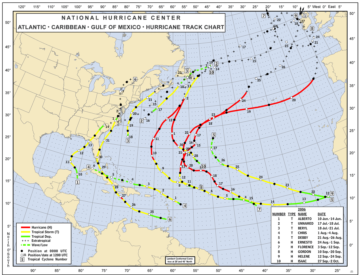
If anyone is wondering what the 2002 season looked like....very typical in terms of numbers...along with a variety of formation points and tracks types (some long trakkers, some fish, some gulf storms...esp lili, and activty off the s.e. coast).
The stats for 2002: 14 depressions, 12 named storms, 4 hurricanes, 2 major hurricanes, 23 reported deaths and $3.11 billion in damages adjusted to 2009 $

Looking at the 2004 season below gives me heartburn...what is interesting is that the season really got going in mid-august through late september...which is when the el nino peaked...the peak 3-month SST anomaly was for the Aug-Sept-Oct period (0.9C)....clearly a reminder that what we are talking about in this thread is one factor in determining if developement is likely or not....not to mention the tracks that these storms took added to the '2004 el nino assault on florida'.
The stats for 2004: 16 depressions, 15 named storms, 9 hurricanes, 6 major hurricanes, 3,132 deaths across the basin (most in haiti) and $57 billion in damages adjusted to 2009 $

Both seasons got going in July (mid-July for 2002 and late-July for 2004).....so at this point (early July) in each of those years, the maps above would have been blank! These are 2 seasons that had el nino conditions that could be comparable to what the 2009 season will bring....not a forecast based on these seasons, but a representation of what has happened historically when just looking at potentially comparable el nino events in terms of strength (measured by sst anomaly over 3-months).
The stats for 2002: 14 depressions, 12 named storms, 4 hurricanes, 2 major hurricanes, 23 reported deaths and $3.11 billion in damages adjusted to 2009 $
Looking at the 2004 season below gives me heartburn...what is interesting is that the season really got going in mid-august through late september...which is when the el nino peaked...the peak 3-month SST anomaly was for the Aug-Sept-Oct period (0.9C)....clearly a reminder that what we are talking about in this thread is one factor in determining if developement is likely or not....not to mention the tracks that these storms took added to the '2004 el nino assault on florida'.
The stats for 2004: 16 depressions, 15 named storms, 9 hurricanes, 6 major hurricanes, 3,132 deaths across the basin (most in haiti) and $57 billion in damages adjusted to 2009 $
Both seasons got going in July (mid-July for 2002 and late-July for 2004).....so at this point (early July) in each of those years, the maps above would have been blank! These are 2 seasons that had el nino conditions that could be comparable to what the 2009 season will bring....not a forecast based on these seasons, but a representation of what has happened historically when just looking at potentially comparable el nino events in terms of strength (measured by sst anomaly over 3-months).
KWT wrote:Yep, I suspect this one will be closest to 2002, given its already at 0.9C in terms of weekly numbers and so I'd expect at least some slow warming over hte next couple of months to take it past 2004 and to be round about level with 2002.
0 likes
-
cycloneye

- Admin

- Posts: 149156
- Age: 69
- Joined: Thu Oct 10, 2002 10:54 am
- Location: San Juan, Puerto Rico
Re: ENSO Updates=30 day SOI turns positive
30 day SOI Index turns positive
Maybe it will be a brief stay at positive territory,but it has reached it after being negative since early May.
2009052120090619 -10.8
2009052220090620 -9.9
2009052320090621 -9.7
2009052420090622 -8
2009052520090623 -7.9
2009052620090624 -6.2
2009052720090625 -5.2
2009052820090626 -4.4
2009052920090627 -4.2
2009053020090628 -2.5
2009053120090629 -2.3
2009060120090630 -2.3
2009060220090701 -2.2
2009060320090702 -.5
2009060420090703 .4

http://www.bom.gov.au/climate/enso/soi.dt3
Maybe it will be a brief stay at positive territory,but it has reached it after being negative since early May.
2009052120090619 -10.8
2009052220090620 -9.9
2009052320090621 -9.7
2009052420090622 -8
2009052520090623 -7.9
2009052620090624 -6.2
2009052720090625 -5.2
2009052820090626 -4.4
2009052920090627 -4.2
2009053020090628 -2.5
2009053120090629 -2.3
2009060120090630 -2.3
2009060220090701 -2.2
2009060320090702 -.5
2009060420090703 .4
http://www.bom.gov.au/climate/enso/soi.dt3
0 likes
-
cycloneye
- Admin
- Posts: 149156
- Age: 69
- Joined: Thu Oct 10, 2002 10:54 am
- Location: San Juan, Puerto Rico
Re: ENSO Updates
New El Nino drought likely, experts warn
July 5, 2009
AUSTRALIA is set to endure its first El Nino since 2006 — and its fifth in 15 years — as water supplies dry up and temperatures continue to rise.
Melbourne could endure its driest year on record as climatologists predict that an El Nino weather event is all but certain to hit Australia and intensify Victoria's drought.
The 2006 El Nino reduced rainfall in some parts of southern Victoria and northern Tasmania to the lowest on record. However, climatologists cannot tell in advance how severe an El Nino will be.
An El Nino event is officially "likely", according to the Bureau of Meteorology's National Climate Centre, "and there's very little chance of the development stalling or reversing".
Such an event could send Melbourne's water storages, already at a record low level of 26 per cent, plummeting well below 20 per cent by next year and force stage 4 restrictions. Rivers — especially the Yarra — farmlands and crops look set to be stressed further.
The prediction comes as the bureau confirmed that Melbourne had a record dry start to the year, with just 126.2 millimetres of rain falling from January to June — eight millimetres below the previous record set in 1967 and less than half the long-term average of 307 millimetres.
"The last time Melbourne's average rainfall was above average was 1996," said Harvey Stern, manager of climate services at the bureau. "Over the 12 years of this drought Melbourne has now missed out on 1.8 metres of rain, representing three years of average rainfall."
Dean Collins, climatologist at the National Climate Centre, said: "We're almost at the point where we'd call it an El Nino … I'd say in the next couple of weeks we'd know for sure."
Mr Collins said all the world's climate models were predicting an El Nino. Six weeks ago only half were.
"All of them are saying we're going to go into a warm event. It looks pretty likely at this stage."
An El Nino could also damage Victoria's harvests, although Victorian Farmers' Federation president Andrew Broad said that grain crops were in the ground and "looking good". He said he was "cautiously optimistic" about the harvests this year and noted that the severity of the El Nino could not be predicted.
Nevertheless, he said farmers "never welcome an El Nino, that's for sure … it will be (a major problem) if it eventuates and doesn't rain".
He said farms that required run-off, especially dairy farms in the north of the state, would suffer the most.
Mr Collins said the impact of an El Nino was usually felt in the second half of the year.
The El Nino-La Nina cycle, a natural part of the climate cycle, is generated by the temperature of the Pacific Ocean. Warmer waters can trigger an El Nino, which brings drought; cooler waters summon a La Nina, which brings increased rainfall.
Melbourne's water storages usually increase only in the second half of the year as inflows outstrip water demand. But during previous El Nino years, rainfall has been so poor that water levels have fallen during the second half.
If Melbourne's storage levels drop like they have in previous El Nino years, they could be below 20 per cent by early 2010.
Melbourne Water spokesman Nicholas McGay said, however, that the city still had 470 billion litres of water in storage and desalination and the north-south pipeline would boost storages. "There's enough in storage until the major projects come online," he said.
http://www.theage.com.au/national/new-e ... -d8hk.html
0 likes

Re: ENSO Updates
Date Tahiti Darwin Daily** 30 day 90 day
Av.SOI Av.SOI
----------------------------------------------------------------
6-Jun-2009 1012.15 1011.95 -7.66 -4.80 0.71
7-Jun-2009 1012.21 1012.20 -9.00 -4.40 0.56
8-Jun-2009 1013.10 1012.15 -2.39 -3.66 0.50
9-Jun-2009 1012.44 1013.85 -18.98 -3.78 0.27
10-Jun-2009 1011.39 1015.25 -36.20 -4.42 -0.20
11-Jun-2009 1008.89 1014.65 -49.56 -5.68 -0.79
12-Jun-2009 1010.47 1014.40 -36.69 -6.61 -1.21
13-Jun-2009 1012.00 1013.50 -19.61 -7.54 -1.40
14-Jun-2009 1012.43 1012.80 -11.67 -8.38 -1.58
15-Jun-2009 1013.93 1011.90 5.20 -8.53 -1.55
16-Jun-2009 1014.44 1012.30 5.97 -8.01 -1.44
17-Jun-2009 1014.00 1014.10 -9.77 -7.68 -1.50
18-Jun-2009 1013.53 1015.15 -20.46 -7.56 -1.76
19-Jun-2009 1012.26 1014.35 -23.76 -7.86 -2.07
20-Jun-2009 1011.70 1013.20 -19.61 -8.34 -2.34
21-Jun-2009 1012.10 1012.40 -11.18 -8.35 -2.49
22-Jun-2009 1014.03 1011.80 6.61 -7.64 -2.45
23-Jun-2009 1014.41 1011.55 11.04 -6.89 -2.31
24-Jun-2009 1014.76 1011.70 12.44 -6.19 -2.05
25-Jun-2009 1015.86 1011.65 20.53 -5.43 -1.68
26-Jun-2009 1016.25 1011.40 25.02 -4.61 -1.35
27-Jun-2009 1017.19 1011.45 31.28 -4.04 -1.03
28-Jun-2009 1016.90 1010.65 34.87 -3.41 -0.62
29-Jun-2009 1016.68 1010.75 32.62 -2.90 -0.20
30-Jun-2009 1016.46 1012.10 21.58 -2.78 -0.15
1-Jul-2009 1015.85 1012.85 12.62 -2.51 -0.15
2-Jul-2009 1014.74 1012.10 10.40 -1.96 -0.12
3-Jul-2009 1014.03 1012.60 2.95 -1.70 -0.10
4-Jul-2009 1014.95 1013.70 1.85 -1.46 -0.12
5-Jul-2009 1015.45 1013.20 8.00 -1.12 -0.17
0 likes


Re: ENSO Updates
SOI has been positive for the past 2 weeks and is starting to rise again. Is this normal for El Nino?
OURAGAN wrote:Date Tahiti Darwin Daily** 30 day 90 day
Av.SOI Av.SOI
----------------------------------------------------------------
6-Jun-2009 1012.15 1011.95 -7.66 -4.80 0.71
7-Jun-2009 1012.21 1012.20 -9.00 -4.40 0.56
8-Jun-2009 1013.10 1012.15 -2.39 -3.66 0.50
9-Jun-2009 1012.44 1013.85 -18.98 -3.78 0.27
10-Jun-2009 1011.39 1015.25 -36.20 -4.42 -0.20
11-Jun-2009 1008.89 1014.65 -49.56 -5.68 -0.79
12-Jun-2009 1010.47 1014.40 -36.69 -6.61 -1.21
13-Jun-2009 1012.00 1013.50 -19.61 -7.54 -1.40
14-Jun-2009 1012.43 1012.80 -11.67 -8.38 -1.58
15-Jun-2009 1013.93 1011.90 5.20 -8.53 -1.55
16-Jun-2009 1014.44 1012.30 5.97 -8.01 -1.44
17-Jun-2009 1014.00 1014.10 -9.77 -7.68 -1.50
18-Jun-2009 1013.53 1015.15 -20.46 -7.56 -1.76
19-Jun-2009 1012.26 1014.35 -23.76 -7.86 -2.07
20-Jun-2009 1011.70 1013.20 -19.61 -8.34 -2.34
21-Jun-2009 1012.10 1012.40 -11.18 -8.35 -2.49
22-Jun-2009 1014.03 1011.80 6.61 -7.64 -2.45
23-Jun-2009 1014.41 1011.55 11.04 -6.89 -2.31
24-Jun-2009 1014.76 1011.70 12.44 -6.19 -2.05
25-Jun-2009 1015.86 1011.65 20.53 -5.43 -1.68
26-Jun-2009 1016.25 1011.40 25.02 -4.61 -1.35
27-Jun-2009 1017.19 1011.45 31.28 -4.04 -1.03
28-Jun-2009 1016.90 1010.65 34.87 -3.41 -0.62
29-Jun-2009 1016.68 1010.75 32.62 -2.90 -0.20
30-Jun-2009 1016.46 1012.10 21.58 -2.78 -0.15
1-Jul-2009 1015.85 1012.85 12.62 -2.51 -0.15
2-Jul-2009 1014.74 1012.10 10.40 -1.96 -0.12
3-Jul-2009 1014.03 1012.60 2.95 -1.70 -0.10
4-Jul-2009 1014.95 1013.70 1.85 -1.46 -0.12
5-Jul-2009 1015.45 1013.20 8.00 -1.12 -0.17
0 likes

Re: ENSO Updates
Lurker wrote:SOI has been positive for the past 2 weeks and is starting to rise again. Is this normal for El Nino?
Simply put, the answer is "no". That's one of the reasons why I'm maintaining my prediction of a WEAK El nino peak (trimonthly peak of +1.0 or lower). I'm currently predicting a peak of +0.9 to +1.0. I expect tomorrow's SOI to also be positive. That would make 15 +'s in a row. I even think it will likely stay positive for about another week after that, which would make it ~23 +'s if verified. To put this into perspective, even just a 15 day streak would be enough to make it a good bit longer than any experienced during any of the other six (pre) El Nino's summers/autumns since 1991: 8 in 1991, 4 in 1994, 8 in 1997, 11 in 2002, 11 in 2004, and 5 in 2006.
Despite the support for a weak peak by the SOI/OLR/PDO, the Oceanic Heat Content (OHC) says otherwise. It suggests the peak will be moderate to strong. So, we have a true battle among various factors. It will be very interesting to see what actually happens.
Last edited by LarryWx on Sun Jul 05, 2009 4:59 pm, edited 1 time in total.
0 likes
-
cycloneye
- Admin
- Posts: 149156
- Age: 69
- Joined: Thu Oct 10, 2002 10:54 am
- Location: San Juan, Puerto Rico
Re: ENSO Updates
LarryWx wrote:Lurker wrote:SOI has been positive for the past 2 weeks and is starting to rise again. Is this normal for El Nino?
Simply out, the answer is "no". That's one of the reasons why I'm maintaining my prediction of a WEAK El nino peak (trimonthly peak of +1.0 or lower). I'm currently predicting a peak of +0.9 to +1.0. I expect tomorrow's SOI to also be positive. That would make 15 +'s in a row. I even think it will likely stay positive for about another week after that, which would make it ~23 +'s if verified. To put this into perspective, even just a 15 day streak would be enough to make it a good bit longer than any experienced during any of the other six (pre) El Nino's summers/autumns since 1991: 8 in 1991, 4 in 1994, 8 in 1997, 11 in 2002, 11 in 2004, and 5 in 2006.
Despite the support for a weak peak by the SOI/OLR/PDO, the Oceanic Heat Content (OHC) says otherwise. It suggests the peak will be moderate to strong. So, we have a true battle among various factors. It will be very interesting to see what actually happens.
Great to see you back Larry.You always good imputs on this theme are always valuable.
0 likes
Re: ENSO Updates
cycloneye wrote:Great to see you back Larry.You always good imputs on this theme are always valuable.
Thanks Luis. ENSO is a fascinating topic to me and it is such an important influence.
0 likes
-
cycloneye
- Admin
- Posts: 149156
- Age: 69
- Joined: Thu Oct 10, 2002 10:54 am
- Location: San Juan, Puerto Rico
Re: ENSO Updates
Latest graphic data as of July 1 of the Anomalies.I notice that the far Eastern Pacific anomalies are not as warm as further west,(El Nino Modoki?)

0 likes
-
cycloneye
- Admin
- Posts: 149156
- Age: 69
- Joined: Thu Oct 10, 2002 10:54 am
- Location: San Juan, Puerto Rico
Re: ENSO Updates
Climate Prediction Center weekly update
http://www.cpc.ncep.noaa.gov/products/a ... ts-web.pdf
The latest weekly CPC Last week SST departures are:
Niño 4= +0.6ºC
Niño 3.4= +0.7ºC
Niño 3= +0.8ºC
Niño1+2= +0.9ºC
The latest weekly CPC [b]This week SST departures are:
Niño 4= 0.7ºC
Niño 3.4= 0.9ºC
Niño 3= 0.9ºC
Niño1+2= 0.6ºC

A reminder that the July update from Climate Prediction Center,when they may or not declare officlally el nino will be on July 9th.Stay tuned for that very important update and dont venture anywhere else as you will find the information first at this thread,before anyone else gets it.
http://www.cpc.ncep.noaa.gov/products/a ... ts-web.pdf
The latest weekly CPC Last week SST departures are:
Niño 4= +0.6ºC
Niño 3.4= +0.7ºC
Niño 3= +0.8ºC
Niño1+2= +0.9ºC
The latest weekly CPC [b]This week SST departures are:
Niño 4= 0.7ºC
Niño 3.4= 0.9ºC
Niño 3= 0.9ºC
Niño1+2= 0.6ºC
A reminder that the July update from Climate Prediction Center,when they may or not declare officlally el nino will be on July 9th.Stay tuned for that very important update and dont venture anywhere else as you will find the information first at this thread,before anyone else gets it.
0 likes
Re: ENSO Updates
SOI just hit 15 days in a row positive. This is getting interesting.
LarryWx wrote:Lurker wrote:SOI has been positive for the past 2 weeks and is starting to rise again. Is this normal for El Nino?
Simply put, the answer is "no". That's one of the reasons why I'm maintaining my prediction of a WEAK El nino peak (trimonthly peak of +1.0 or lower). I'm currently predicting a peak of +0.9 to +1.0. I expect tomorrow's SOI to also be positive. That would make 15 +'s in a row. I even think it will likely stay positive for about another week after that, which would make it ~23 +'s if verified. To put this into perspective, even just a 15 day streak would be enough to make it a good bit longer than any experienced during any of the other six (pre) El Nino's summers/autumns since 1991: 8 in 1991, 4 in 1994, 8 in 1997, 11 in 2002, 11 in 2004, and 5 in 2006.
Despite the support for a weak peak by the SOI/OLR/PDO, the Oceanic Heat Content (OHC) says otherwise. It suggests the peak will be moderate to strong. So, we have a true battle among various factors. It will be very interesting to see what actually happens.
0 likes
-
wxman57

- Moderator-Pro Met

- Posts: 23170
- Age: 68
- Joined: Sat Jun 21, 2003 8:06 pm
- Location: Houston, TX (southwest)
Re: ENSO Updates
Meanwhile, SST anomalies in the Tropical Pacific continue to rise well above the El Nino threshold, and sub-surface water is even warmer than last week:

I think that we may well see a season that's more similar to 2006 than 2004, with little activity across the Caribbean, a couple storms in the Gulf, but most activity north of the Caribbean and east of the U.S.
I think that we may well see a season that's more similar to 2006 than 2004, with little activity across the Caribbean, a couple storms in the Gulf, but most activity north of the Caribbean and east of the U.S.
0 likes
Re: ENSO Updates
Interesting to see the Niño1+2 anomalies fall and the Central Pacific area rise.
cycloneye wrote:Climate Prediction Center weekly update
http://www.cpc.ncep.noaa.gov/products/a ... ts-web.pdf
The latest weekly CPC Last week SST departures are:
Niño 4= +0.6ºC
Niño 3.4= +0.7ºC
Niño 3= +0.8ºC
Niño1+2= +0.9ºC
The latest weekly CPC [b]This week SST departures are:
Niño 4= 0.7ºC
Niño 3.4= 0.9ºC
Niño 3= 0.9ºC
Niño1+2= 0.6ºC
A reminder that the July update from Climate Prediction Center,when they may or not declare officlally el nino will be on July 9th.Stay tuned for that very important update and dont venture anywhere else as you will find the information first at this thread,before anyone else gets it.
0 likes
Re: ENSO=CPC Weekly Update Posted / July Update at 7/9/09
So, NINO 3.4 stayed at +0.9 based on today's weekly SST release. Let's see whether or not it finally cools for awhile within the next few weeks. It wouldn't surprise me.
0 likes
-
cycloneye
- Admin
- Posts: 149156
- Age: 69
- Joined: Thu Oct 10, 2002 10:54 am
- Location: San Juan, Puerto Rico
Re: ENSO Updates=CPC 7/6/09 Weekly Update
What peeled me more was the decrease at el nino 1+2 from 0.9C last week to this weeks 0.6C.
0 likes
Re: ENSO Updates=CPC 7/6/09 Weekly Update
Luis,
You accidentally put two weeks ago under the "last week" label. That's why I said that 3.4 didn't change. Last week's #'s were actually as follows:
24JUN2009 1+2: +0.8 3: +1.0 3.4: +0.9 4: +0.7
So, here are the comparisons to last week:
24JUN2009 1+2: +0.8 3: +1.0 3.4: +0.9 4: +0.7
01JUL2009 1+2: +0.6 3: +0.9 3.4 +0.9 3: +0.7
There still was a change in 1+2 of -0.2. However, 1+2 is VERY volatile compared to, say, 3.4. It can move very rapidly up or down in any given week since it is a small area. So, this drop is not that big of a deal IMHO. So, that's one reason I feel that short-term moves in 3.4 are more foretelling. IF I were to see a move of -0.2 in 3.4, I'd consider that to be a more important move than a -0.2 in 1+2. I'll be looking for drops like that in the weeks to come to give a weak El Nino peak a chance. Let's see what happens through July. This is so much fun to follow.
Last edited by LarryWx on Mon Jul 06, 2009 3:10 pm, edited 1 time in total.
0 likes
-
cycloneye
- Admin
- Posts: 149156
- Age: 69
- Joined: Thu Oct 10, 2002 10:54 am
- Location: San Juan, Puerto Rico
Re: ENSO Updates=CPC 7/6/09 Weekly Update
Larry,a question about the SOI index.What do you see in that as it has risen to positive at the 30 day data?
0 likes
Re: ENSO Updates=CPC 7/6/09 Weekly Update
cycloneye wrote:Larry,a question about the SOI index.What do you see in that as it has risen to positive at the 30 day data?
Luis,
That tells me that there is a decent chance that NINO 3.4 takes a break from the recent rather rapid warming and cools back some for awhile...kind of like a stock market "correction" after a rapid rise. But the ocean heat content (OHC) is high currently. So, there is a lot of uncertainty as to how much it would cool. I'm guessing it will cool as we go through July. The crucial thing is how much/how long it cools. IF it is large/long enough, it may allow for only a weak El Nino peak in th4 fall/winter, which is what I've been predicting since May. I'm currently predicting a trimonthly (not weekly) peak in 3.4 of +0.9 to +1.0. Weeklies could still go as high as +1.3 and maybe even +1.4 and still allow for a +1.0 trimonthly peak due to the math/typical topping pattern.
0 likes
-
cycloneye
- Admin
- Posts: 149156
- Age: 69
- Joined: Thu Oct 10, 2002 10:54 am
- Location: San Juan, Puerto Rico
Re: ENSO Updates=CPC 7/6/09 Weekly Update
30 Day SOI Index continues to rise
It may be a temporaty rise,but its no stopping of the 30 day SOI index as it continues to climb in positive territory,today at +1.2.
2009051520090613 -11.5
2009051620090614 -10.6
2009051720090615 -9.7
2009051820090616 -8.7
2009051920090617 -8.7
2009052020090618 -10.1
2009052120090619 -10.8
2009052220090620 -9.9
2009052320090621 -9.7
2009052420090622 -8
2009052520090623 -7.9
2009052620090624 -6.2
2009052720090625 -5.2
2009052820090626 -4.4
2009052920090627 -4.2
2009053020090628 -2.5
2009053120090629 -2.3
2009060120090630 -2.3
2009060220090701 -2.2
2009060320090702 -.5
2009060420090703 +.4
2009060520090704 +.4
2009060620090705 +1.2
http://www.bom.gov.au/climate/enso/soi.dt3
For those members who dont know what the SOI (Southern Occillation Index) is and what effects it has on ENSO here is a complete explanation.
http://www.bom.gov.au/climate/glossary/soi.shtml
0 likes
Who is online
Users browsing this forum: No registered users and 82 guests