ENSO Updates (2007 thru 2023)
Moderator: S2k Moderators
Forum rules
The posts in this forum are NOT official forecasts and should not be used as such. They are just the opinion of the poster and may or may not be backed by sound meteorological data. They are NOT endorsed by any professional institution or STORM2K. For official information, please refer to products from the National Hurricane Center and National Weather Service.
- cycloneye
- Admin

- Posts: 149156
- Age: 69
- Joined: Thu Oct 10, 2002 10:54 am
- Location: San Juan, Puerto Rico
Re: ENSO Updates
As I see things,I dont see El Nino in a big hurry to show up.It may come in a couple of weeks or in a month but as of right now with the SOI rising,the numbers stalling just below 1.0C at El Niño 3-4 causes a pause to us to be in a wait and see mode.


0 likes
- cycloneye
- Admin

- Posts: 149156
- Age: 69
- Joined: Thu Oct 10, 2002 10:54 am
- Location: San Juan, Puerto Rico
Re: ENSO Updates=30 day SOI index continues to rise
Here are the CFS model projections for ENSO.It looks like it wont reach 1.5C until late September.Also by August and September,it continues to show that small dip.I am not saying anything,only interpreting what the projection shows,so dont shoot the messanger. 


0 likes
- wxman57
- Moderator-Pro Met

- Posts: 23170
- Age: 68
- Joined: Sat Jun 21, 2003 8:06 pm
- Location: Houston, TX (southwest)
Re: ENSO Updates=30 day SOI index continues to rise
Although an El Nino now appears certain, there are questions about its intensity. The current upward trend in the SOI would suggest the temperature rise in the Tropical Pacific will level off over the next month, leading to a weak to moderate El Nino. This would likely be strong enough to hinder development in the deep tropics of the Atlantic Basin.
Another factor is the projected higher pressures in the Atlantic by the European for August/September. We're already seeing evidence of this in the stronger-than-normal easterly trades south of 20N. The stronger trades are resulting in more upwelling of cool water in the MDR, with the warmer water staying north of 20N. This pattern is quite different than we saw in 2004, where the warmer water was concentrated in the MDR and into the Gulf. Also, the water in the East Pac in 2004 wasn't nearly as warm.
Everything is point to a relatively quiet season numbers-wise. Let's just hope it's now "quiet" as in 1957, 1965, 1983 or 1992 (all seasons with 8 or fewer named storms). I don't have to go into details of what happened in these "quiet" years, do I? You can check them out here if you don't remember:
http://weather.unisys.com/hurricane/atlantic/index.html
0 likes
- cycloneye
- Admin

- Posts: 149156
- Age: 69
- Joined: Thu Oct 10, 2002 10:54 am
- Location: San Juan, Puerto Rico
Re: ENSO Updates=30 day SOI index continues to rise
57,do you think by the peak months (August / September) el nino will be weak to moderate already or only weak?
0 likes
- wxman57
- Moderator-Pro Met

- Posts: 23170
- Age: 68
- Joined: Sat Jun 21, 2003 8:06 pm
- Location: Houston, TX (southwest)
Re: ENSO Updates=30 day SOI index continues to rise
cycloneye wrote:57,do you think by the peak months (August / September) el nino will be weak to moderate already or only weak?
Depends on what the definitions of "weak" or "moderate" El Nino are. By August, the anomaly may be between +1.0 and +1.5C in Nino 3.4 as well as Nino 1 and 2. That would be a little stronger than 2004, more similar to 2002 in terms of strength. But, again, we had much warmer Atlantic SSTs in the MDR back then and lower trade winds.
Here's a good weekly discussion on El Nino/La Nina with some great table of previous El Nino/La Nina values:
http://www.cpc.ncep.noaa.gov/products/a ... ts-web.pdf
0 likes
- cycloneye
- Admin

- Posts: 149156
- Age: 69
- Joined: Thu Oct 10, 2002 10:54 am
- Location: San Juan, Puerto Rico
Re: ENSO Updates
Australians 7/8/09 ENSO Update
They say strong indicators of El Nino persist.Read the update at hyperlink below.
ENSO Wrap-Up
A reminder that tommorow the Climate Prediction Center July update will be released.
They say strong indicators of El Nino persist.Read the update at hyperlink below.
ENSO Wrap-Up
A reminder that tommorow the Climate Prediction Center July update will be released.
0 likes
I suspect what we are seeing now was what was modelled by the models recently, a small dip possibly developing over the summer months, should prevent us from going into the moderate region for a few months though likely the effect will still be enough to supress hurricanes in the Atlantic...though it may also prevent as many strong hurricanes in the EPAC as well compared to what you'd expect in a developing El Nino, we shall see.
0 likes
- cycloneye
- Admin

- Posts: 149156
- Age: 69
- Joined: Thu Oct 10, 2002 10:54 am
- Location: San Juan, Puerto Rico
Re:
KWT wrote:I suspect what we are seeing now was what was modelled by the models recently, a small dip possibly developing over the summer months, should prevent us from going into the moderate region for a few months though likely the effect will still be enough to supress hurricanes in the Atlantic...though it may also prevent as many strong hurricanes in the EPAC as well compared to what you'd expect in a developing El Nino, we shall see.
Yes,agree with all of what you said.I am curious about how the EPAC will end up in activity as it has started very slow with some kind of El Nino kicking in.
0 likes
- cycloneye
- Admin

- Posts: 149156
- Age: 69
- Joined: Thu Oct 10, 2002 10:54 am
- Location: San Juan, Puerto Rico
Re: ENSO Updates=Climate Prediction Center July update tommorow
It will be interesting to see if Climate Prediction Center in its July update comming out tommorow will pull the trigger and declare El Nino officially,or if they wont do it yet waiting for more data.As usual,only you can see the update faster than other sites so stay tuned tommorow morning. 
0 likes
- cycloneye
- Admin

- Posts: 149156
- Age: 69
- Joined: Thu Oct 10, 2002 10:54 am
- Location: San Juan, Puerto Rico
Re: ENSO Updates=Climate Prediction Center July update tommorow

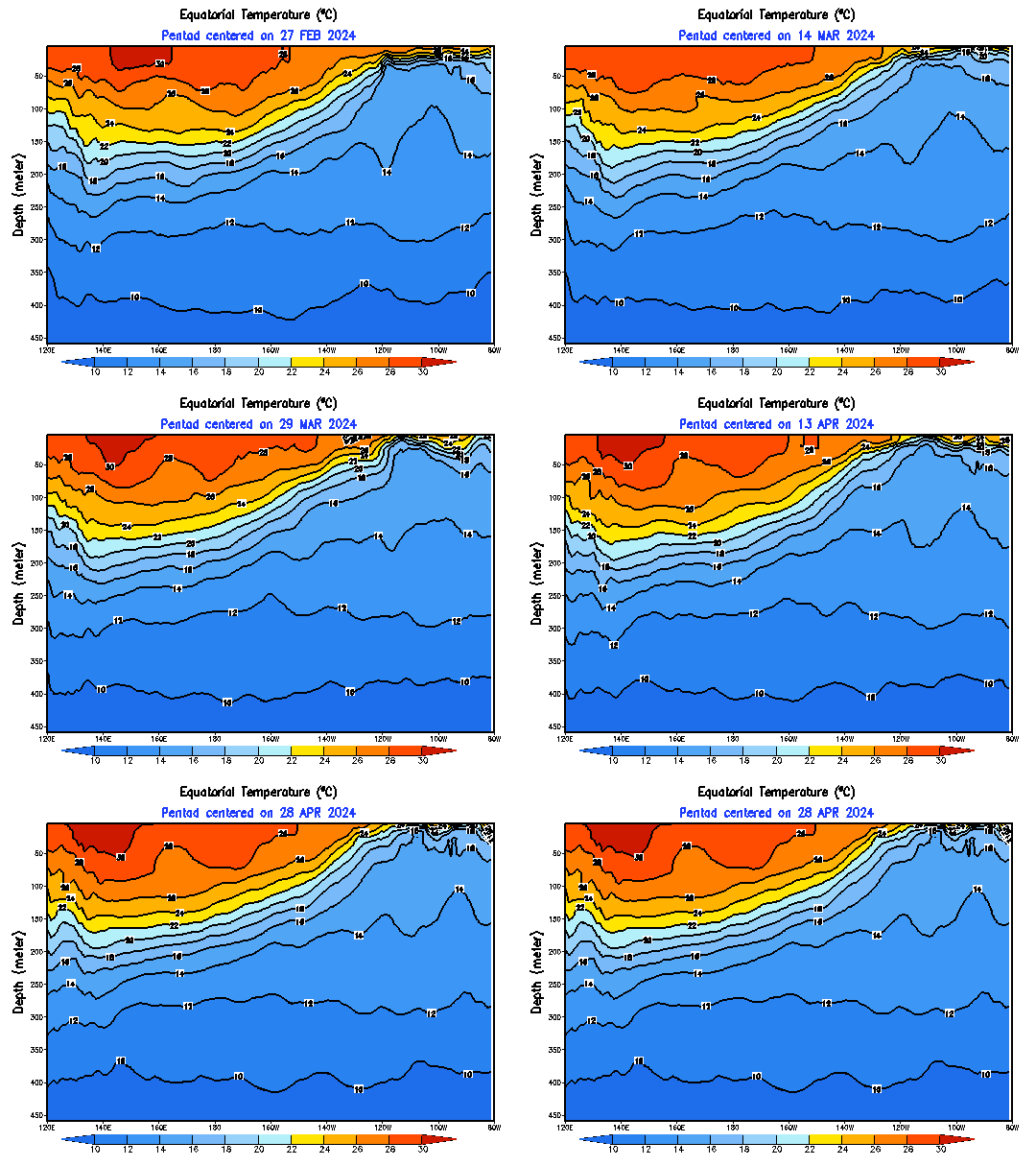
This is the depth graphic that shows how the thermocline is doing in the Pacific.It shows a much warmer pacific from 140W westward (El Nino 3-4).
0 likes
- cycloneye
- Admin

- Posts: 149156
- Age: 69
- Joined: Thu Oct 10, 2002 10:54 am
- Location: San Juan, Puerto Rico
Re: ENSO Updates
The big question for the rest of this year is,which of these past El Nino events 2009 will have? The modoki El Ninos are those at the right when the Central equatorial Pacific was warmer than the Eastern equatorial Pacific and the normal El Nino events are at the left.
The graphics are with the number of named storms,/hurricanes/major hurricanes that those years had.

The graphics are with the number of named storms,/hurricanes/major hurricanes that those years had.

0 likes
- Emmett_Brown
- Category 5

- Posts: 1433
- Joined: Wed Aug 24, 2005 9:10 pm
- Location: Sarasota FL
Re: ENSO Updates
cycloneye wrote:The big question for the rest of this year is,which of these past El Nino events 2009 will have? The modoki El Ninos are those at the right when the Central equatorial Pacific was warmer than the Eastern equatorial Pacific and the normal El Nino events are at the left.
The graphics are with the number of named storms,/hurricanes/major hurricanes that those years had.
One interesting thing to note is that all the other Eastern based el nino years depicted in this graphic had below normal water temps north of Australia. So far, 2009 temps are above normal there. It is the below normal temps usually associated with El Nino that cause drought in Australia. Only half of the Modoki years depicted show below normal temps N of Aus. Perhaps it is just too soon in the event, but could this also support the idea of a more West based El Nino?
0 likes
- cycloneye
- Admin

- Posts: 149156
- Age: 69
- Joined: Thu Oct 10, 2002 10:54 am
- Location: San Juan, Puerto Rico
Re: ENSO=Breaking News=CPC 7/9/09 July Update=El Nino Arrives
Climate Prediction Center July Update=El Nino has been declared officially.
El Nino has been declared by CPC.Read the July Update below.
Synopsis: El Niño conditions will continue to develop and are expected to last through the Northern Hemisphere Winter 2009-2010.
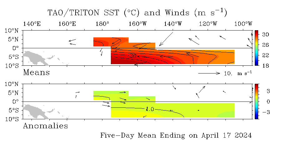
During June 2009, conditions across the equatorial Pacific Ocean transitioned from ENSO-neutral to El Niño conditions. Sea surface temperature (SST) anomalies continued to increase, with the latest weekly departures exceeding +1.0°C along a narrow band in the eastern equatorial Pacific (Fig. 1). All of the weekly SST indices increased steadily during June and now range from +0.6°C to +0.9°C (Fig. 2). Subsurface oceanic heat content anomalies (average temperatures in the upper 300m of the ocean, Fig. 3) also increased as the thermocline continued to deepen (Fig. 4). Consistent with the oceanic evolution, the low-level equatorial trade winds were weaker-than-average across much of the Pacific basin, and convection became increasingly suppressed over Indonesia. This coupling of the ocean and atmosphere indicates the development of El Niño conditions.
Model forecasts of SST anomalies for the Niño-3.4 region (Fig. 5) reflect a growing consensus for the continued development of El Niño (+0.5°C or greater in the Niño-3.4 region). However, the spread of the models indicates disagreement over the eventual strength of El Niño (+0.5°C to +2.0°C). Current conditions and recent trends favor the continued development of a weak-to-moderate strength El Niño into the Northern Hemisphere Fall 2009, with further strengthening possible thereafter.
Expected El Niño impacts during July-September 2009 include enhanced precipitation over the central and west-central Pacific Ocean, along with the continuation of drier than average conditions over Indonesia. Temperature and precipitation impacts over the United States are typically weak during the Northern Hemisphere Summer and early Fall, and generally strengthen during the late Fall and Winter. El Niño can help to suppress Atlantic hurricane activity by increasing the vertical wind shear over the Caribbean Sea and tropical Atlantic Ocean. The NOAA Atlantic Seasonal Hurricane Outlook issued in May (will be updated on Aug. 6th) indicates the highest probabilities for a near-average season.
http://www.cpc.ncep.noaa.gov/products/a ... odisc.html
Below is the Spanish translation of the El Nino Advisory
El Boletin sobre la declaracion de El Niño oficialmente por Climate Prediction Center
Para aquellos miembros que no sepan ingles aqui esta el boletin de Climate Prediction Center sobre la llegada de El Niño oficialmente.
Sinopsis: Condiciones de El Niño continuarán desarrollándose y se espera que duren hasta el Invierno del Hemisferio Norte 2009-2010.
Durante el mes de junio de 2009, ocurrió una transición en las condiciones a través del Océano Pacífico ecuatorial de condiciones de ENSO-neutral a El Niño. Las anomalías en la temperatura de la superficie del mar ecuatorial (SST, por sus siglas en inglés), continuaban aumentando con las últimas desviaciones semanales excediendo +1.0°C a través de una estrecha banda en el este del Pacífico ecuatorial (Fig. 1). Todos los índices semanales de SST aumentaron continuamente durante el mes de junio y ahora fluctuando entre +0.6°C a +0.9°C (Fig. 2). Las anomalías del contenido calórico en la sub-superficie oceánica (temperaturas promedio en los 300m superiores del océano, Fig. 3) aumentaron también a medida que la capa termoclinal continuaba profundizando (Fig. 4). En consistencia con la evolución oceánica, los vientos alisios ecuatoriales en los niveles bajos de la atmósfera estuvieron más débiles de lo normal a través de gran parte de la cuenca del Pacífico y la convección se tornó aun más suprimida sobre Indonesia. Esta combinación del océano con la atmósfera demuestra el desarrollo de las condiciones de El Niño.
Los modelos de pronósticos de las anomalías de SST para la región del Niño-3.4 (Fig. 5) reflejan un consenso en crecimiento para el desarrollo continuo de El Niño (+0.5°C o mayor en la región de el Niño-3.4). Sin embargo, la extensión de los modelos muestra una discrepancia en el fortalecimiento eventual de El Niño (+0.5°C a +2.0°C). Las condiciones actuales y las tendencias recientes favorecen el desarrollo continuo de un fortalecimiento de débil-a-moderado de El Niño hasta el otoño 2009 del Hemisferio Norte, con posibilidad de fortalecimiento a partir de entonces.
Los impactos esperados de El Niño durante los meses de julio-septiembre 2009 incluyen un aumento en la precipitación sobre partes del centro y oeste-central del Océano Pacífico, junto con la continuación de condiciones más secas de lo normal sobre Indonesia. Los impactos en la temperatura y precipitación sobre Estados Unidos son típicamente más débiles durante el verano del Hemisferio Norte y a principios de otoño, y se fortalecen generalmente durante la postrimería de otoño e invierno. El Niño, puede ayudar a suprimir la actividad de huracanes en el Atlántico aumentando el gradiente de vientos vertical sobre el Mar Caribe y el Océano Atlántico tropical. El pronóstico de NOAA sobre la temporada de huracanes en el Atlántico emitido en mayo (será actualizado el 6 de agosto) indica las probabilidades mayores para una temporada cerca del promedio.
http://www.cpc.ncep.noaa.gov/products/a ... sc_Sp.html
0 likes
-
Stormcenter
- S2K Supporter

- Posts: 6689
- Joined: Wed Sep 03, 2003 11:27 am
- Location: Houston, TX
Re: ENSO=Breaking News=CPC 7/9/09 July Update=El Nino Arrives
This is GREAT news for those looking for a below normal hurricane season.
0 likes
- cycloneye
- Admin

- Posts: 149156
- Age: 69
- Joined: Thu Oct 10, 2002 10:54 am
- Location: San Juan, Puerto Rico
Re: ENSO=Breaking News=CPC 7/9/09 July Update=El Nino declared
Now two questions loom large,how strong this El Nino will be and how will be the timeframe for it to be in the Pacific.
0 likes
Re: ENSO=Breaking News=CPC 7/9/09 July Update=El Nino declared
Now, I'm worried. They say that El Niño will be weak to moderate into Fall but further strengthening is possible and that means little rain for Central America next year. In 2007 rainy season started in late June, one month later than average, and there were some crop losses. The good thing is that we could have strongest shots of cold air during late Fall and Winter, on november 2006 San Salvador reached 12 ºC (54 ºF) when the average low for november is 17 ºC (63 ºF) and the yearly average low is 20 º (68 º).
0 likes
- HouTXmetro
- Category 5

- Posts: 3949
- Joined: Sun Jun 13, 2004 6:00 pm
- Location: District of Columbia, USA
Re: ENSO=Breaking News=CPC 7/9/09 July Update=El Nino declared
Macrocane wrote:Now, I'm worried. They say that El Niño will be weak to moderate into Fall but further strengthening is possible and that means little rain for Central America next year. In 2007 rainy season started in late June, one month later than average, and there were some crop losses. The good thing is that we could have strongest shots of cold air during late Fall and Winter, on november 2006 San Salvador reached 12 ºC (54 ºF) when the average low for november is 17 ºC (63 ºF) and the yearly average low is 20 º (68 º).
Wonderful weather to have lows in the mid 60's in November!
0 likes
- cycloneye
- Admin

- Posts: 149156
- Age: 69
- Joined: Thu Oct 10, 2002 10:54 am
- Location: San Juan, Puerto Rico
Re: ENSO=Breaking News=CPC 7/9/09 July Update=El Nino Arrives
Stormcenter wrote:This is GREAT news for those looking for a below normal hurricane season.
That is true,but remember the famous phrase (it only takes one).
0 likes
Who is online
Users browsing this forum: No registered users and 58 guests


