http://www.meteo.fr/temps/domtom/antill ... Tagant.jpg
Convection is repopping steadily...
ATL: INVEST (97L)
Moderator: S2k Moderators

-
cycloneye

- Admin

- Posts: 149278
- Age: 69
- Joined: Thu Oct 10, 2002 10:54 am
- Location: San Juan, Puerto Rico
Re: ATL: INVEST (97L)
gatorcane,that is why the Tropics are like a pandora,full of surprises and many things occur when you dont expect,but also it happens the other way around.
0 likes
-
Gustywind

- Category 5

- Posts: 12334
- Joined: Mon Sep 03, 2007 7:29 am
- Location: Baie-Mahault, GUADELOUPE
Hurdles of shear, Olympics shear Games for 97L not easy...
From wunderground.com, Jeff Masters last update this morning
http://www.wunderground.com/blog/JeffMa ... rynum=1260
Dr. Jeff Masters' WunderBlog
Last Updated: 13:51 GMT le 20 juillet 2009 — Last Comment: 13:55 GMT le 20 juillet 2009
High wind shear ripping into 97L
Posted by: JeffMasters, 13:49 GMT le 20 juillet 2009
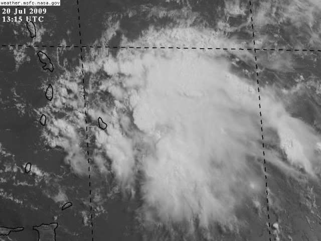
A strong tropical wave (97L) a few hundred miles east of Barbados in the Lesser Antilles Islands has grown less organized today as it tracks west at 15 - 20 mph. The wave is moving underneath an upper-level trough of low pressure, which is bringing 30 knots of wind shear to the 97L. While there is a respectable amount of heavy thunderstorm activity associated with 97L, there is no longer any low-level spiral banding or rotation of the cloud pattern. This morning's QuikSCAT pass at 5:35 am EDT showed sustained winds of 35 mph a few hundred miles east of Barbados, but there was no surface circulation evident. The islands of Barbados, St. Vincent and the Grenadines, St. Lucia, and Martinique can expect heavy rain and wind gusts to 50 mph as 97L moves through the Lesser Antilles Islands this afternoon and tonight, but 97L will not become a tropical depression.
Wind shear along the path of 97L is forecast to remain in the high 25 - 35 knot range for at least the next three days. This should prevent further development of 97L, and I expect the disturbance will be gradually torn apart during the next few days. The National Hurricane Center gives 97L a low (less than 30% chance) of developing into a tropical depression in the next 48 hours. None of the computer models are forecasting any tropical storm development over the next seven days.
Figure 1. Current satellite image of African wave 97L.
I'll have an update Tuesday morning. As 97L moves through the islands, you may want to follow local observations there using our wundermap for the region.
Jeff Masters
From wunderground.com, Jeff Masters last update this morning
http://www.wunderground.com/blog/JeffMa ... rynum=1260
Dr. Jeff Masters' WunderBlog
Last Updated: 13:51 GMT le 20 juillet 2009 — Last Comment: 13:55 GMT le 20 juillet 2009
High wind shear ripping into 97L
Posted by: JeffMasters, 13:49 GMT le 20 juillet 2009
A strong tropical wave (97L) a few hundred miles east of Barbados in the Lesser Antilles Islands has grown less organized today as it tracks west at 15 - 20 mph. The wave is moving underneath an upper-level trough of low pressure, which is bringing 30 knots of wind shear to the 97L. While there is a respectable amount of heavy thunderstorm activity associated with 97L, there is no longer any low-level spiral banding or rotation of the cloud pattern. This morning's QuikSCAT pass at 5:35 am EDT showed sustained winds of 35 mph a few hundred miles east of Barbados, but there was no surface circulation evident. The islands of Barbados, St. Vincent and the Grenadines, St. Lucia, and Martinique can expect heavy rain and wind gusts to 50 mph as 97L moves through the Lesser Antilles Islands this afternoon and tonight, but 97L will not become a tropical depression.
Wind shear along the path of 97L is forecast to remain in the high 25 - 35 knot range for at least the next three days. This should prevent further development of 97L, and I expect the disturbance will be gradually torn apart during the next few days. The National Hurricane Center gives 97L a low (less than 30% chance) of developing into a tropical depression in the next 48 hours. None of the computer models are forecasting any tropical storm development over the next seven days.
Figure 1. Current satellite image of African wave 97L.
I'll have an update Tuesday morning. As 97L moves through the islands, you may want to follow local observations there using our wundermap for the region.
Jeff Masters
0 likes


Re: ATL: INVEST (97L)
The fact it is still there says it has something. The July Caribbean should be harsh on such a weak system. Remember Dolly though, it was sputtering all the way up to when it formed over in the Gulf. Though I wouldn't compare the two since this is weaker. This could be shear flaring up until it dissipates like wave #1.
0 likes
-
Gustywind
- Category 5
- Posts: 12334
- Joined: Mon Sep 03, 2007 7:29 am
- Location: Baie-Mahault, GUADELOUPE
DATE/TIME LAT LON CLASSIFICATION STORM
20/1145 UTC 13.7N 58.0W T1.0/1.0 97L -- Atlantic
http://www.ssd.noaa.gov/PS/TROP/tdpositions.html
20/1145 UTC 13.7N 58.0W T1.0/1.0 97L -- Atlantic
http://www.ssd.noaa.gov/PS/TROP/tdpositions.html
0 likes

Re: ATL: INVEST (97L)
Conditions in Barbados have deteriorated very heavy rain at this time. Good thing convection was supposed to be reduced, would hate to know what it would have been if it had not.
0 likes
-
cycloneye
- Admin
- Posts: 149278
- Age: 69
- Joined: Thu Oct 10, 2002 10:54 am
- Location: San Juan, Puerto Rico
Re: ATL: INVEST (97L)
If any member wants to see how are things evolving in the islands,you can go to Weather Attic forum,at the Eastern Caribbean thread,where the Caribbean members are posting their observations.
Link to Eastern Caribbean Thread at Weather Attic forum.
viewtopic.php?f=20&t=85676&start=0
Link to Eastern Caribbean Thread at Weather Attic forum.
viewtopic.php?f=20&t=85676&start=0
0 likes
-
Gustywind
- Category 5
- Posts: 12334
- Joined: Mon Sep 03, 2007 7:29 am
- Location: Baie-Mahault, GUADELOUPE
This little boy continues to show us her little teeth in a growing trend: little burst of convection is expanding in the northern quadrant and a slight better appareance in spite of the high shear values doting the area near Windwards/Leewards Islands
Barbados is now expericing a bulk of moderate to strong convection
http://www.ssd.noaa.gov/goes/east/carb/loop-ir2.html
Barbados is now expericing a bulk of moderate to strong convection
http://www.ssd.noaa.gov/goes/east/carb/loop-ir2.html
0 likes
-
tolakram
- Admin
- Posts: 20179
- Age: 62
- Joined: Sun Aug 27, 2006 8:23 pm
- Location: Florence, KY (name is Mark)
Re: ATL: INVEST (97L)
I just don't believe conditions down there are going to improve any time soon. We're seeing record cool weather (high temps) up here and if you look at the eastern US there is really nowhere for anything to move north out of the way. We're still in a spring like pattern and it's mid-July. 
I hope this doesn't mean an oppressively hot August and September.
I hope this doesn't mean an oppressively hot August and September.
0 likes
-
Ed Mahmoud
Re: ATL: INVEST (97L)
If this isn't just variable winds in a t-shower, we may be on to something. Lots of storms, but sure looks disorganized.
From E Caribbean thread
From E Caribbean thread
cycloneye wrote:Conditions in Barbados.Code: Select all
Conditions at  Jul 20, 2009 - 11:10 AM EDTJul 20, 2009 - 10:10 AM CDTJul 20, 2009 - 09:10 AM MDTJul 20, 2009 - 08:10 AM PDTJul 20, 2009 - 07:10 AM ADTJul 20, 2009 - 06:10 AM HDT
2009.07.20 1510 UTC
Wind  from the SSW (200 degrees) at 6 MPH (5 KT)
Visibility  1 mile(s)
Sky conditions  mostly cloudy
Weather  Rain with thunder
Cumulonimbus clouds observed
Temperature  77 F (25 C)
Dew Point  75 F (24 C)
Relative Humidity  94%
Pressure (altimeter)  29.88 in. Hg (1012 hPa)
ob  TBPB 201510Z 20005KT 3000 TSRA SCT008CB SCT010 BKN100 25/24 Q1012

--------------------------------------------------------------------------------
SSW winds
http://www.srh.noaa.gov/sju/?n=observations01
0 likes
-
ExBailbonds

- Tropical Storm

- Posts: 142
- Joined: Wed Sep 06, 2006 12:03 am
- Location: Homestead,Fl
- Contact:
Re: ATL: INVEST (97L)
It appears to be getting a little rotation back. It's fighting the shear for sure but it does not want to give up and go away easily.
0 likes
-
Ed Mahmoud
Re: ATL: INVEST (97L)
Actually, Barbados should not be getting SSW winds unless there is a low center well ahead of the convection.
OK, the above post stolen from Cycloneye isn't as exciting as I thought...
OK, the above post stolen from Cycloneye isn't as exciting as I thought...
0 likes
-
Ed Mahmoud
Re: ATL: INVEST (97L)
Is that the second cousin of all outflow boundaries racing off to the North and West?
Usually not a sign of a particularly healthy system...
Usually not a sign of a particularly healthy system...
0 likes

Re: ATL: INVEST (97L)
Be patient if your looking for development, I still believe Ana will form within 48hrs.
0 likes
-
cycloneye
- Admin
- Posts: 149278
- Age: 69
- Joined: Thu Oct 10, 2002 10:54 am
- Location: San Juan, Puerto Rico
Re: ATL: INVEST (97L)
canes04 wrote:Be patient if your looking for development, I still believe Ana will form within 48hrs.
And your reasoning is?
0 likes
-
gatorcane

- S2K Supporter

- Posts: 23708
- Age: 48
- Joined: Sun Mar 13, 2005 3:54 pm
- Location: Boca Raton, FL
Re: ATL: INVEST (97L)
cycloneye wrote:canes04 wrote:Be patient if your looking for development, I still believe Ana will form within 48hrs.
And your reasoning is?
The posts in this forum are NOT official forecast and should not be used as such. They are just the opinion of the poster and may or may not be backed by sound meteorological data. They are NOT endorsed by any professional institution or storm2k.org. For official information, please refer to the NHC and NWS products.
I don't see Ana forming at all. We are just seeing some convection blowing up due to the interaction with shear, nothing more.
Even if if it were to develop, it is not likely going to develop fast enough to become Anna before moving north of the Caribbean islands in a couple of days. Then should it deepen, its likely going to pass right of Florida and the Eastern CONUS anyway as the semi-permanent Eastern CONUS trough (reminiscent of a winter-time setup) blocks anything coming close.
I just took a look at the VIS over Florida and what I see is a pretty impressive short-wave trough for July, looks like a December setup to me...
I think the NAM runs have the setup correct as you can see all of the moisture passing just East of Florida and through the Bahamas....
Last edited by gatorcane on Mon Jul 20, 2009 11:47 am, edited 1 time in total.
0 likes
-
wxman57

- Moderator-Pro Met

- Posts: 23172
- Age: 68
- Joined: Sat Jun 21, 2003 8:06 pm
- Location: Houston, TX (southwest)
Re: ATL: INVEST (97L)
canes04 wrote:Be patient if your looking for development, I still believe Ana will form within 48hrs.
I'll take that bet.
Fortunately, it appears that the model projections of diminishing wind shear were dead wrong. Shear is eating 97L alive. There may be a very brief period in 36-48 hours when shear could drop a bit, but that window won't last long (if it actually materializes). I think we'll have to look elsewhere for Ana. (August 8th).
0 likes
Who is online
Users browsing this forum: No registered users and 59 guests