SE TX/SW LA weather: Much cooler and WET after Tuesday
Moderator: S2k Moderators
Forum rules

The posts in this forum are NOT official forecast and should not be used as such. They are just the opinion of the poster and may or may not be backed by sound meteorological data. They are NOT endorsed by any professional institution or STORM2K.
-
southerngale

- Retired Staff

- Posts: 27418
- Joined: Thu Oct 10, 2002 1:27 am
- Location: Southeast Texas (Beaumont area)
-
southerngale
- Retired Staff
- Posts: 27418
- Joined: Thu Oct 10, 2002 1:27 am
- Location: Southeast Texas (Beaumont area)
Re: SE TX/SW LA weather: Summer Pattern-HOT!!!
I hope these guys make a full recovery.  Also, geez... could these people have any more rotten luck?
Lightning strikes home, several hurt
Lightning has struck a home under construction in Sabine Pass and eight people have been hurt, one critically, according to information from Port Arthur Police Chief Mark Blanton.
Blanton says authorities called for a number of ambulances to respond to 5505 Bufford Street in Sabine Pass at about 3:30 Thursday afternoon.
Construction workers were finishing the roof connection on two halves of a modular home when lightning struck the highest pitch point on the roof.
The roof caught on fire and the eight construction workers were hurt.
Firefighters say several were on the roof and the others were under the home.
The critically injured worker was taken by ambulance to a Houston hospital.
Five others were taken to area hospitals by ambulance and the remaining two were taken by private vehicles.
Chief Blanton says six of the workers are from the Houston area and the two others are from the Port Arthur area.
The homeowners, Sidney and Cindy Davis, weren't hurt.
Authorities say the modular home is owned by a family whose home was destroyed in Hurricane Rita and again in Hurricane Ike.
Stay with KFDM News for the latest on the story.
0 likes
-
srainhoutx

- S2K Supporter

- Posts: 6919
- Age: 68
- Joined: Sun Jan 14, 2007 11:34 am
- Location: Haywood County, NC
- Contact:
Re: SE TX/SW LA weather: Summer Pattern-HOT!!!
Going to be a bit of a messy rush hour this morning as an Upper Air disturbance moves across our are in the NW flow. Could get a few more storms this afternoon with daytime heating as well. I think it's fairly safe to say that most of us (sorry Jason ) have seen some rainfall this past week. Now we will watch and wait to see if some guidance is correct in a more active period after the weekend...
http://radar.weather.gov/Conus/southpla ... e_loop.php
http://radar.weather.gov/Conus/southpla ... e_loop.php
0 likes
-
Ed Mahmoud
Re: SE TX/SW LA weather: Summer Pattern-HOT!!!
AREA FORECAST DISCUSSION
NATIONAL WEATHER SERVICE HOUSTON/GALVESTON TX
628 AM CDT FRI JUL 24 2009
.DISCUSSION...
SEE AVIATION DISCUSSION.
&&
.AVIATION...
A MID LEVEL CLOUD DECK WAS GENERATING SCATTERED SHOWERS THIS
MORNING. EXPECT THESE TO DISSIPATE BY AROUND 14Z. ANOTHER ROUND OF
LATE AFTERNOON AND EARLY EVENING ISOLATED SHOWERS OR THUNDERSTORMS
IS POSSIBLE LATER TODAY...MAINLY BETWEEN 22Z AND 02Z. OTHERWISE...
MAINLY VFR CONDITIONS EXPECTED. A FEW TERMINALS MAY EXPERIENCE
MVFR CONDITIONS FOR A SHORT PERIOD EARLY THIS MORNING AND AGAIN
FRIDAY MORNING DUE TO MAINLY LIGHT FOG.
40
&&
.PREV DISCUSSION... /ISSUED 340 AM CDT FRI JUL 24 2009/
DISCUSSION...
AT 08Z...A WEAK BOUNDARY WAS LOCATED FROM ABOUT LA GRANGE TO
HUNTSVILLE TO JASPER. THE BOUNDARY HAS BECOME EXTREMELY DIFFUSE.
SATELLITE DERIVED PW`S SHOWS A NARROW CORRIDOR OF DEEPER MOISTURE
ALONG THE I-10 CORRIDOR WITH DRIER AIR TO THE NORTH AND SOUTH OF
THIS AREA. A SWATH OF VERY LIGHT RAIN OVER CENTRAL TEXAS WILL PUSH
EAST AND AFFECT THE NORTHWEST ZONES PRIOR TO SUNRISE. THE RAIN
AREA IS EXPECTED TO WEAKEN AS IT MOVES EAST. NAM 12 AND 4 KM WRF
DID A GREAT JOB YESTERDAY BUT ALAS TODAY IS A NEW DAY AND THESE
MODELS ARE NOT IN GOOD AGREEMENT AT ALL. THE NAM 12 IS MORE
AGGRESSIVE WITH RAIN CHANCES LATE THIS AFTERNOON CLOSE TO WHERE
THE BOUNDARY IS. THE WRF/GFS ARE MUCH DRIER AND DO NOT SHOW MUCH
IN THE WAY OF PRECIP TODAY. WATER VAPOR IMAGERY SHOWS A SLUG OF
DRIER AIR WORKING INTO THE REGION FROM THE NORTH BUT IT ALSO SHOWS
AN UPPER LEVEL DISTURBANCE HEADING THIS WAY BY LATE AFTERNOON.
FORECAST SOUNDINGS SHOW CONVECTIVE TEMPS AROUND 93-94 DEGREES SO
CONVECTION...IF ANY...SHOULD BEGIN DURING THE LATE AFTERNOON. FEEL
CURRENT FORECAST WITH 30 POPS OVER THE SOUTHEAST CORNER OF THE CWA
AND 20`S ELSEWHERE IS A GOOD PLACE TO START. OVER THE WEEKEND...AN
UPPER LEVEL HIGH WILL SHIFT SLIGHTLY EASTWARD. BUILDING HEIGHTS
WILL BRING AN INCREASE IN TEMPERATURES...ESPECIALLY OVER THE
WESTERN ZONES. RAIN CHANCES WILL DECREASE AS THE RIDGE IMPARTS
SOME SUBSIDENCE. SLIGHTLY DEEPER MOISTURE ON SUNDAY WARRANTS THE
MENTION OF POPS. THE RIDGE ALSO BEGINS TO SHIFT WESTWARD BY
SUNDAY EVENING. AN UPPER LEVEL TROUGH WILL CROSS THE CENTRAL
PLAINS MID WEEK. THIS FEATURE COUPLED WITH AN INCREASE IN LOW
LEVEL MOISTURE SHOULD BRING A GOOD CHANCE OF RAIN TUES-THURS.
GLOBAL MODELS ARE FURTHER NORTH WITH THE TROUGH THAN PAST RUNS BUT
DYNAMICS STILL LOOK STRONG ENOUGH TO CONTINUE WITH CHANCE POPS.
TROPICS STILL LOOK QUIET. 43
I think they are backing off on the dusting off the flood insurance.
Rained twice at the house since last Saturday, I could use more.
0 likes
Re: SE TX/SW LA weather: Summer Pattern-HOT!!!
Had some light showers move through this morning..I can only hope this is indicative of the day as we missed out on everything yesterday.
0 likes
-
jasons2k

- Storm2k Executive

- Posts: 8290
- Age: 52
- Joined: Wed Jul 06, 2005 12:32 pm
- Location: The Woodlands, TX
Yes, I had some showers this morning too. It was just enough to wet the leaves (probably only a trace or .01" in the rain guage) but I'll take what I can get. 
Hopefully next week I will get some real rain, but I'm not getting my hopes-up just yet.
Remember from previous commentary I have this non-scientific theory that when flooding is forecasted several days in advance it never lives-up to expectations. It's the events that aren't forecasted very well that end-up dumping on us at the last minute and leaving us wondering where the heck that came from....
0 likes
-
cctxhurricanewatcher

- Category 5

- Posts: 1206
- Joined: Sun Sep 12, 2004 8:53 pm
- Location: Corpus Christi, Texas
Re:
jasons wrote:Yes, I had some showers this morning too. It was just enough to wet the leaves (probably only a trace or .01" in the rain guage) but I'll take what I can get.
Hopefully next week I will get some real rain, but I'm not getting my hopes-up just yet.
Remember from previous commentary I have this non-scientific theory that when flooding is forecasted several days in advance it never lives-up to expectations. It's the events that aren't forecasted very well that end-up dumping on us at the last minute and leaving us wondering where the heck that came from....
NWS Corpus Christi has been pretty spot on during this prolonged dry spell/heat wave. They are not excited at all about the potential for rain next week. They make a good case why in this discussion from early this AM. Even our local TV mets who bite at any chance of rain since this drought started are stressing "isolated" showers if at all. When I see them say that in normal times, I then grab my canoe. But they are on the same page with the NWS this time around it appears.
AREA FORECAST DISCUSSION
NATIONAL WEATHER SERVICE CORPUS CHRISTI TX
416 AM CDT FRI JUL 24 2009
.LONG TERM (SATURDAY NIGHT THROUGH FRIDAY)...MODELS ARE IN FAIRLY
GOOD AGREEMENT WITH RESPECT TO THE SYNOPTIC PATTERN THROUGH THE
EXTENDED PERIOD. THE MID/UPPER LEVEL HIGH PRESSURE WILL SHIFT
FURTHER WEST OF THE REGION...WITH AN MID/UPPER TROUGH EXTENDING
ACROSS THE CENTRAL PLAINS INTO EAST TEXAS. BEGINNING EARLY NEXT
WEEK...THIS SETUP WILL ALLOW MULTIPLE UPPER LEVEL WEAKNESSES IN THE
NORTHWESTERLY FLOW ALOFT TO POTENTIALLY AFFECT SOUTH TEXAS. DEEPER
TROPICAL MOISTURE IS ALSO PROGGED TO MOVE INTO THE AREA NEXT WEEK
ALL OF THESE FACTORS WILL GENERALLY RESULT IN AN INCREASE IN PRECIP
CHANCES DURING THE MONDAY THROUGH FRIDAY TIME FRAME. HOWEVER...FOR
NOW WILL NOT COMPLETELY BITE ON THIS SCENARIO GIVEN THE PATTERN
SOUTH TEXAS HAS BEEN IN THE PAST MONTH OR SO AND THE FACT THAT THE
AREA REMAINS IN A HISTORIC DROUGHT AND THE MODELS CONTINUE TO HAVE A
HARD TIME RESOLVING THE EXTREMELY DRY SOILS. THEREFORE...AM ONLY
SHOWING SLIGHT CHANCE POPS ACROSS THE NORTHERN AND EASTERN PORTIONS
OF THE CWFA FOR NEXT WEEK...AS TIMING AND LOCATION OF ANY CONVECTION
THAT FORMS WILL BE DIFFICULT SINCE IT WILL BE MAINLY MESOSCALE IN
NATURE. MAXIMUM TEMPS WILL REMAIN WELL ABOVE NORMAL SUNDAY...WITH A
SLIGHT DECREASE EXPECTED EARLY NEXT WEEK (BUT WILL STILL BE ABOVE
NORMAL) AS MORE CLOUDS AND MOISTURE RETURN. GENERALLY REMAINED NEAR
GUIDANCE FOR THE OVERNIGHT LOWS.
0 likes
-
Yankeegirl

- Category 5
- Posts: 3417
- Age: 50
- Joined: Sun May 23, 2004 11:59 pm
- Location: Cy-Fair, Northwest Houston
- Contact:
-
southerngale
- Retired Staff
- Posts: 27418
- Joined: Thu Oct 10, 2002 1:27 am
- Location: Southeast Texas (Beaumont area)
Re:
Yankeegirl wrote:So any word on the rain event for next week? Im already ready for some more wet stuff!!
Well, our rain chances went from about 20% or 30% (which is what it was last night) to 60% on Monday, then it's 50% for Tuesday and Wednesday, and 40% for Thursday and Friday. That's according to NWS Lake Charles, for this area. I didn't check, but I would imagine it's somewhat similar for your area.
0 likes
-
Ed Mahmoud
Re: SE TX/SW LA weather: Summer Pattern-HOT!!!
Most of the scattered cells are fizzling at the first hint of being past peak heating, but one good cell in Louisiana crossing into Texas.
SEVERE THUNDERSTORM WARNING
LAC019-TXC351-361-260000-
/O.NEW.KLCH.SV.W.0148.090725T2336Z-090726T0000Z/
BULLETIN - EAS ACTIVATION REQUESTED
SEVERE THUNDERSTORM WARNING
NATIONAL WEATHER SERVICE LAKE CHARLES LA
636 PM CDT SAT JUL 25 2009
THE NATIONAL WEATHER SERVICE IN LAKE CHARLES HAS ISSUED A
* SEVERE THUNDERSTORM WARNING FOR...
SOUTH CENTRAL NEWTON COUNTY IN SOUTHEAST TEXAS...
THIS INCLUDES THE CITY OF DEWEYVILLE...
EASTERN ORANGE COUNTY IN SOUTHEAST TEXAS...
THIS INCLUDES THE CITIES OF...WEST ORANGE...ORANGE...
WESTERN CALCASIEU PARISH IN SOUTHWEST LOUISIANA...
THIS INCLUDES THE CITIES OF...VINTON...STARKS...
* UNTIL 700 PM CDT
* AT 632 PM CDT...NATIONAL WEATHER SERVICE METEOROLOGISTS DETECTED A
SEVERE THUNDERSTORM CAPABLE OF PRODUCING PENNY SIZE HAIL...AND
DAMAGING WINDS IN EXCESS OF 60 MPH. THIS STORM WAS LOCATED
FROM 8 MILES NORTHEAST OF VINTON...AND MOVING WEST AT 15 MPH.
* SEVERE THUNDERSTORMS WILL BE NEAR...
VINTON BY 650 PM CDT...
STARKS...DEWEYVILLE AND ORANGE BY 700 PM CDT...
0 likes
-
vbhoutex

- Storm2k Executive
- Posts: 29149
- Age: 74
- Joined: Wed Oct 09, 2002 11:31 pm
- Location: Cypress, TX
- Contact:
Re: Re:
southerngale wrote:Yankeegirl wrote:So any word on the rain event for next week? Im already ready for some more wet stuff!!
Well, our rain chances went from about 20% or 30% (which is what it was last night) to 60% on Monday, then it's 50% for Tuesday and Wednesday, and 40% for Thursday and Friday. That's according to NWS Lake Charles, for this area. I didn't check, but I would imagine it's somewhat similar for your area.
Ours rain chances are at 40% for Tuesday/Wednesday, down from "get out your flood insurance". Even with the rains some of us have had the whole area still needs a good, steady, soaking rain and another good, steady, soaking rain and another good, steady, soaking rain ...
0 likes
-
srainhoutx
- S2K Supporter
- Posts: 6919
- Age: 68
- Joined: Sun Jan 14, 2007 11:34 am
- Location: Haywood County, NC
- Contact:
Re: SE TX/SW LA weather: Summer Pattern-HOT!!!
Not so fast. HGX has bumped up rain chances through mid week as guidance has changed just a bit. Not too sure I'm buying the "death ridge" moving back E as much as the Burmuda High sliding in from the E...
AREA FORECAST DISCUSSION
NATIONAL WEATHER SERVICE HOUSTON/GALVESTON TX
309 AM CDT SUN JUL 26 2009
.DISCUSSION...
AT 07Z...A COLD FRONT EXTENDED ACROSS THE TEXAS PANHANDLE FROM
DALHART TO GAGE TO TULSA. FURTHER SOUTH...A WEAK ONSHORE FLOW
CONTINUED TO BRING DEEPER MOISTURE INTO SOUTHEAST TEXAS. AT 850
MB...DEEPER MOISTURE WAS GENERALLY CONFINED EAST OF THE SABINE RIVER
WITH CAPPING EVIDENT FROM ABOUT DFW TO CRP. AN UPPER LEVEL RIDGE
WAS CENTERED OVER NEW MEXICO. UPPER FLOW WAS OUT OF THE NORTH AND
BROADLY DIVERGENT. A STRONG UPPER LEVEL DISTURBANCE IS PROGGED TO
MOVE SOUTH LATE THIS AFTERNOON IN THE NORTHERLY UPPER FLOW. WILL
LEAN TOWARD THE 4 KM WRF WHICH DEVELOPS TSRA AROUND 23Z AND THESE
STORMS WILL BACK BUILD WESTWARD AS THE STORMS MOVE SOUTH. STORMS
ARE EXPECTED TO DISSIPATE NEAR THE I-10 CORRIDOR. FORECAST
SOUNDINGS SHOW DECENT CAPE AND MOISTURE AND A WELL DEFINED
INVERTED V SIGNATURE. THE STRONGER STORMS WILL PRODUCE GUSTY
WINDS.
MOISTURE LEVELS WILL EXCEED 2 INCHES ON MONDAY. UPPER LEVEL WINDS
ARE DIVERGENT AND AN UPPER LEVEL TROUGH WILL GRADUALLY RETROGRADE
INTO TEXAS. CONDITIONS APPEAR FAVORABLE FOR WIDESPREAD RAINFALL
AND HAVE BUMPED POPS TO HIGH END CHANCE. MOISTURE LEVELS REMAIN
NEAR 2 INCHES ON TUES/WED SO WILL MAINTAIN CHANCE POPS. MOISTURE
LEVELS BEGIN TO WANE A BIT THU/FRI BUT AN UPPER LEVEL WEAKNESS
WILL REMAIN OVER THE CENTRAL PLAINS EXTENDING INTO TEXAS. WILL
CONTINUE TO CARRY CHANCE POPS DUE TO THE GENERAL TROUGHINESS. THE
TROUGH BEGINS TO MOVE EAST NEXT WEEKEND WITH A FLAT RIDGE
BEGINNING TO DEVELOP. RAIN CHANCES SHOULD DIMINISH AND
TEMPERATURES SHOULD BEGIN TO WARM. 43
Plenty of time for things to change again IMHO.
0 likes
-
jasons2k
- Storm2k Executive
- Posts: 8290
- Age: 52
- Joined: Wed Jul 06, 2005 12:32 pm
- Location: The Woodlands, TX
Re: SE TX/SW LA weather: Summer Pattern-HOT!!!
http://www.spc.noaa.gov/products/md/md1676.html
MESOSCALE DISCUSSION 1676
NWS STORM PREDICTION CENTER NORMAN OK
0945 AM CDT SUN JUL 26 2009
AREAS AFFECTED...W CENTRAL AND SWRN MS/NRN AND CENTRAL LA/PARTS OF E
TX
CONCERNING...SEVERE POTENTIAL...WATCH POSSIBLE
VALID 261445Z - 261645Z
LOOSELY-ORGANIZED CLUSTER OF STORMS FROM NRN MS WWD TO NE TX MAY
INTENSIFY BY EARLY AFTERNOON...POSSIBLY REQUIRING EVENTUAL WW
ISSUANCE.
RADAR IMAGERY CONTINUES TO SHOW SWD-MOVING STORMS DEVELOPING IN A
DISCONTINUOUS BAND FROM NE TX ENEWD INTO NRN MS -- WITH THE MOST
VIGOROUS ACTIVITY -- CAPABLE OF PRODUCING MARGINALLY-SEVERE HAIL --
NOW OVER NWRN MS. STORMS APPEAR TO BE ELEVATED...BEING FED FROM THE
W BY A WEAK WLY LOW-LEVEL JET. THE BOUNDARY-LAYER AIRMASS AHEAD OF
THE CONVECTION REMAINS QUITE MOIST...AND WITH VISIBLE IMAGERY
SHOWING ONLY SCATTERED CLOUDS...EXPECT MODERATE DESTABILIZATION TO
OCCUR IN CONJUNCTION WITH DIURNAL HEATING.
WHILE HIGH-RES MODEL DATA SUGGESTS SOME POTENTIAL FOR CONVECTIVE
WEAKENING AS THE LOW-LEVEL JET DIMINISHES INTO THE
AFTERNOON...DESTABILIZING AIRMASS COULD ALTERNATIVELY SUPPORT A
CONVECTIVE INCREASE -- PARTICULARLY IF AN ORGANIZED COLD
POOL/OUTFLOW CAN EVOLVE THIS MORNING FROM THE ONGOING STORMS. WHILE
DEEP-LAYER WIND FIELD IS NOT PARTICULARLY STRONG...A SWD-MOVING
CLUSTER OF STORMS AT THE LEADING EDGE OF A COLD POOL -- MOVING SWD
AT 20 TO 30 KT IN NLY MEAN FLOW -- COULD RESULT IN A HEIGHTENED
THREAT FOR DAMAGING WINDS. WHILE THIS SCENARIO REMAINS
UNCERTAIN...WE WILL CONTINUE TO MONITOR ONGOING CONVECTION FOR SIGNS
OF COLD POOL ORGANIZATION AND SUBSEQUENT TRANSITION TO PRIMARILY
SURFACE-BASED STORMS -- WHICH WOULD THEN REQUIRE WW ISSUANCE.
0 likes
-
srainhoutx
- S2K Supporter
- Posts: 6919
- Age: 68
- Joined: Sun Jan 14, 2007 11:34 am
- Location: Haywood County, NC
- Contact:
-
PTrackerLA

- Category 5
- Posts: 5281
- Age: 42
- Joined: Thu Oct 10, 2002 8:40 pm
- Location: Lafayette, LA
Re: SE TX/SW LA weather: Summer Pattern-HOT!!!
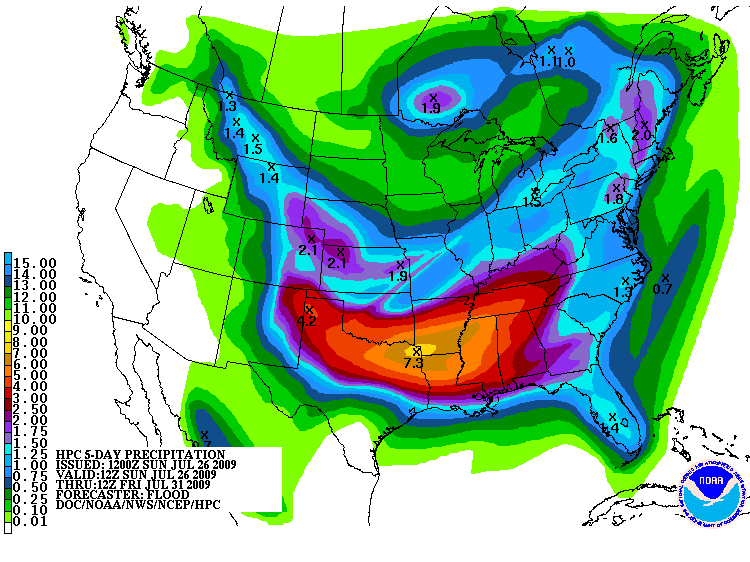
That is a HUGE area of 4" or more rainfall accumulations!
0 likes
-
Yankeegirl
- Category 5
- Posts: 3417
- Age: 50
- Joined: Sun May 23, 2004 11:59 pm
- Location: Cy-Fair, Northwest Houston
- Contact:
-
southerngale
- Retired Staff
- Posts: 27418
- Joined: Thu Oct 10, 2002 1:27 am
- Location: Southeast Texas (Beaumont area)
Re: SE TX/SW LA weather: Summer Pattern-HOT!!!
They nudged pops up a little here. Including today, the next 7 days are now 30/60/60/50/40/40/40
It's getting a little better here, already. They lifted the burn ban locally for 40 hours, starting yesterday morning at 6am, until tonight at 10pm. Unfortunately, I didn't know about it until early this morning. And I even saw a little smoke yesterday, and thought somebody was gonna get in trouble! I'll know it's much better when the burn ban gets lifted for good. If this week is as wet as expected, that just might happen.
Good luck to everyone!
Overnight AFD from Lake Charles NWS:
<snippet>
FEW OVERALL CHANGES TO THE FORECAST AS MODELS CONTINUE TO
INDICATE A VERY WET WEEK AHEAD. DRY AIR ALOFT WILL ONCE AGAIN
LIMIT OVERALL COVERAGE OF SHOWERS AND THUNDERSTORMS TODAY BUT WITH
PWATS HIGHER THAN YESTERDAY WILL GO WITH LOW CHANCE POPS. 4.0 KM
WRF INDICATES POTENTIAL MCS DEVELOPMENT IN THE ARKLATEX REGION
THIS MORNING WITH ACTIVITY MOVING SOUTHWARD INTO THE CWA DURING
THE AFTERNOON AND EVENING HOURS. DUE TO THE RECENT STELLAR
PERFORMANCE OF THIS MODEL...HAVE NO REASON TO DOUBT IT AND HAVE
HIGHEST POPS IN NORTHERN ZONES FOR THIS AFTERNOON AND TONIGHT TO
ACCOUNT FOR THIS POTENTIAL. WITH DRY AIR ALOFT BETWEEN 850-500MB
MAY ONCE AGAIN SEE A FEW STRONG STORMS WITH LARGE HAIL AND
DAMAGING WIND POTENTIAL...AND IN FACT SPC HAS A SLIGHT RISK TO OUR
NORTH.
MONDAY SIGNALS THE BEGINNING OF THREE DAYS OF WIDESPREAD
PRECIPITATION AS INCREASINGLY DEEP SOUTHERLY FLOW OFF THE GULF
COMBINES WITH A LARGE UPPER LEVEL TROUGH DIGGING SOUTHWARD FROM
THE NORTHERN CONUS. PWATS RISING WELL ABOVE 2 INCHES...CONVECTIVE
TEMPS IN THE 80S AND GENEROUS DEEP LAYER LIFT ALL SUGGEST LIKELY
POPS ARE WARRANTED AT LEAST MONDAY AND TUESDAY...AND POSSIBLY
WEDNESDAY AS WELL. ACTIVITY APPEARS LIKELY TO DEVELOP IN THE
COASTAL WATERS DURING THE EARLY MORNING HOURS...THEN GRADUALLY
DEVELOP INTO SOUTHERN ZONES DURING THE MORNING AND NORTHERN ZONES
BY AFTERNOON. AS HAS BEEN THE CASE MUCH OF THIS MONTH...CANNOT
RULE OUT A FEW ISOLATED STRONG TO SEVERE STORMS EACH DAY ALTHOUGH
WIDESPREAD SEVERE WEATHER IS NOT ANTICIPATED. IN ADDITION...WITH
PWATS SO HIGH...LOCALIZED FLOODING IS ALSO POSSIBLE IN AREAS THAT
SEE INTENSE RAINFALL RATES OR REPEATED THUNDERSTORM DEVELOPMENT.
LOOKS LIKE HIGH TEMPERATURES WILL STRUGGLE TO GET OUT OF THE 80S
THESE THREE DAYS DUE TO THE WIDESPREAD PRECIP AND CLOUD COVER.
Edited Sunday night: The forecast changed a bit. Starting Monday (the 2nd pops above), 40/70/50/40/40/40/40
(50% Monday night)
It's getting a little better here, already. They lifted the burn ban locally for 40 hours, starting yesterday morning at 6am, until tonight at 10pm. Unfortunately, I didn't know about it until early this morning. And I even saw a little smoke yesterday, and thought somebody was gonna get in trouble!
Good luck to everyone!
Overnight AFD from Lake Charles NWS:
<snippet>
FEW OVERALL CHANGES TO THE FORECAST AS MODELS CONTINUE TO
INDICATE A VERY WET WEEK AHEAD. DRY AIR ALOFT WILL ONCE AGAIN
LIMIT OVERALL COVERAGE OF SHOWERS AND THUNDERSTORMS TODAY BUT WITH
PWATS HIGHER THAN YESTERDAY WILL GO WITH LOW CHANCE POPS. 4.0 KM
WRF INDICATES POTENTIAL MCS DEVELOPMENT IN THE ARKLATEX REGION
THIS MORNING WITH ACTIVITY MOVING SOUTHWARD INTO THE CWA DURING
THE AFTERNOON AND EVENING HOURS. DUE TO THE RECENT STELLAR
PERFORMANCE OF THIS MODEL...HAVE NO REASON TO DOUBT IT AND HAVE
HIGHEST POPS IN NORTHERN ZONES FOR THIS AFTERNOON AND TONIGHT TO
ACCOUNT FOR THIS POTENTIAL. WITH DRY AIR ALOFT BETWEEN 850-500MB
MAY ONCE AGAIN SEE A FEW STRONG STORMS WITH LARGE HAIL AND
DAMAGING WIND POTENTIAL...AND IN FACT SPC HAS A SLIGHT RISK TO OUR
NORTH.
MONDAY SIGNALS THE BEGINNING OF THREE DAYS OF WIDESPREAD
PRECIPITATION AS INCREASINGLY DEEP SOUTHERLY FLOW OFF THE GULF
COMBINES WITH A LARGE UPPER LEVEL TROUGH DIGGING SOUTHWARD FROM
THE NORTHERN CONUS. PWATS RISING WELL ABOVE 2 INCHES...CONVECTIVE
TEMPS IN THE 80S AND GENEROUS DEEP LAYER LIFT ALL SUGGEST LIKELY
POPS ARE WARRANTED AT LEAST MONDAY AND TUESDAY...AND POSSIBLY
WEDNESDAY AS WELL. ACTIVITY APPEARS LIKELY TO DEVELOP IN THE
COASTAL WATERS DURING THE EARLY MORNING HOURS...THEN GRADUALLY
DEVELOP INTO SOUTHERN ZONES DURING THE MORNING AND NORTHERN ZONES
BY AFTERNOON. AS HAS BEEN THE CASE MUCH OF THIS MONTH...CANNOT
RULE OUT A FEW ISOLATED STRONG TO SEVERE STORMS EACH DAY ALTHOUGH
WIDESPREAD SEVERE WEATHER IS NOT ANTICIPATED. IN ADDITION...WITH
PWATS SO HIGH...LOCALIZED FLOODING IS ALSO POSSIBLE IN AREAS THAT
SEE INTENSE RAINFALL RATES OR REPEATED THUNDERSTORM DEVELOPMENT.
LOOKS LIKE HIGH TEMPERATURES WILL STRUGGLE TO GET OUT OF THE 80S
THESE THREE DAYS DUE TO THE WIDESPREAD PRECIP AND CLOUD COVER.
Edited Sunday night: The forecast changed a bit. Starting Monday (the 2nd pops above), 40/70/50/40/40/40/40
(50% Monday night)
0 likes
-
jasons2k
- Storm2k Executive
- Posts: 8290
- Age: 52
- Joined: Wed Jul 06, 2005 12:32 pm
- Location: The Woodlands, TX
I wish burn bans were permanent. It's not allowed in my neighborhood but it is allowed in the one just south of me, and in the fall the whole neighborhood turns into a smoky, sooty mess. It's particulary offending to a parent of a preemie baby with fragile lungs.
And even further south, I never understood why they allow any burning in Harris County at all, often home to the nation's most polluted air...or why they ban personal burning while developers are allowed to let their mountains of pine trees smolder for weeks and weeks.
(end soap box)
Anyway, I don't mean to hijack the thread. Watching storms pop towards Lake Livingston. I sure hope it becomes more widespread later this afternooon.
0 likes
-
vbhoutex
- Storm2k Executive
- Posts: 29149
- Age: 74
- Joined: Wed Oct 09, 2002 11:31 pm
- Location: Cypress, TX
- Contact:
Re: SE TX/SW LA weather: Summer Pattern-HOT!!!
Well, we are under a tornado warning for the cell that just passed us. It is heading wnw and is building nnw as it moves and has gone severe on radar. It didn't get anywhere near severe here, but a few miles to our nnw radar shows it as severe. Unfortunately, if it continues to build, it is heading towards sraintx's house and both of my children's homes. Hopefully it is not producing any tornados(radar doesn't indicate any, but it definitely looked like it was at severe on the radar to our nnw). We probably got less than 1/2" here, but every little bit helps. The water bill is loving it!
0 likes
Return to “USA & Caribbean Weather”
Who is online
Users browsing this forum: wxman22 and 114 guests