Quad Cities Tornado Hell Storm?
Moderator: S2k Moderators
Forum rules

The posts in this forum are NOT official forecast and should not be used as such. They are just the opinion of the poster and may or may not be backed by sound meteorological data. They are NOT endorsed by any professional institution or STORM2K.
-
Ed Mahmoud
-
Ed Mahmoud
Re: Quad Cities Tornado Hell Storm?
SEVERE WEATHER STATEMENT
NATIONAL WEATHER SERVICE LA CROSSE WI
219 PM CDT FRI JUL 24 2009
IAC043-241945-
/O.CON.KARX.TO.W.0014.000000T0000Z-090724T1945Z/
CLAYTON IA-
219 PM CDT FRI JUL 24 2009
...A TORNADO WARNING REMAINS IN EFFECT UNTIL 245 PM CDT FOR SOUTHERN
CLAYTON COUNTY...
AT 219 PM CDT...NATIONAL WEATHER SERVICE DOPPLER RADAR CONTINUED TO
INDICATE A TORNADO. THIS TORNADO WAS LOCATED NEAR BIXBY STATE PARK...
OR 12 MILES NORTH OF MANCHESTER...MOVING SOUTHEAST AT 30 MPH.
* THE TORNADO WILL BE NEAR...
WOOD AROUND 225 PM...
UPDEGRAFF AND FAIRVIEW AROUND 230 PM...
PRECAUTIONARY/PREPAREDNESS ACTIONS...
CARS AND MOBILE HOMES SHOULD BE ABANDONED FOR A STURDY BUILDING. AS A
LAST RESORT...LAY FLAT IN A DITCH AND COVER YOUR HEAD.
TAKE COVER IN A BASEMENT OR IN AN INTERIOR ROOM ON THE LOWEST FLOOR
AND STAY AWAY FROM WINDOWS!
A TORNADO WATCH REMAINS IN EFFECT UNTIL 500 PM FRIDAY AFTERNOON FOR
NORTHEAST IOWA AND SOUTHWEST WISCONSIN.
&&
LAT...LON 4280 9161 4280 9119 4265 9121 4264 9161
TIME...MOT...LOC 1920Z 322DEG 24KT 4265 9143
$$
DTJ
0 likes
-
Ed Mahmoud
Re: Quad Cities Tornado Hell Storm?
Tornado warning down, and radial velocity mode looks more benign, but DVN warning of tennis ball sized hail. Not sure if that is based of VILS or ground truth or what.
0 likes
-
wall_cloud

- Professional-Met

- Posts: 401
- Age: 49
- Joined: Sun Dec 04, 2005 7:32 am
- Location: Bartlett, TN
- Contact:
Re: Quad Cities Tornado Hell Storm?
I think most forecasters do not use VIL as a basis for hail size. Sure, its a tool that can be used in the overall analysis of a storm but there are better measures of hail potential. The trained eye will pay attention to reflectivies aloft and the persistence of these elevated cores. Some is based on ground truth but much is based on experience.
0 likes
-
Ed Mahmoud
Re: Quad Cities Tornado Hell Storm?
wall_cloud wrote:I think most forecasters do not use VIL as a basis for hail size. Sure, its a tool that can be used in the overall analysis of a storm but there are better measures of hail potential. The trained eye will pay attention to reflectivies aloft and the persistence of these elevated cores. Some is based on ground truth but much is based on experience.
Local TV weather people (some mets, some not) use TV station doppler algorithms to give hail size estimates, I assumed it was based on VILS, but then I used to see discussion (not so much anymore) in AFDs about the day's threshold of VIL for severe hail. So I wasn't sure how local TV people do it.
I will say, Dr. Forbes on TWC has that software that lets him do cross-sections of t-storms, he showed it a lot during VORTEX 2, that was a cool toy.
0 likes
-
wall_cloud
- Professional-Met
- Posts: 401
- Age: 49
- Joined: Sun Dec 04, 2005 7:32 am
- Location: Bartlett, TN
- Contact:
Re: Quad Cities Tornado Hell Storm?
He is probably using a version of Gibson Ridge software, likely GR2analylist (which is very nice). We have a similar functionality in AWIPS that produces cross-sections. I find the cross sections to be as useful as the individual slices. You can pick out features such as bounded weak echo regions quite easily as determine the height of the reflectivity core and infrer storm tilt.
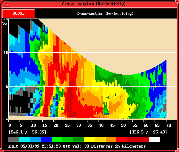
Full volume scans are quite nice as well. This is an example of the 60+ dbz core of a supercell in Oklahoma. You can easily see the elevated reflectivity core and the weak echo region.
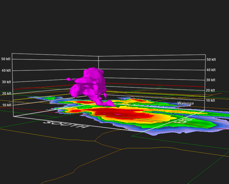
Full volume scans are quite nice as well. This is an example of the 60+ dbz core of a supercell in Oklahoma. You can easily see the elevated reflectivity core and the weak echo region.
0 likes
Return to “USA & Caribbean Weather”
Who is online
Users browsing this forum: HockeyTx82 and 158 guests