Global model runs discussion
Moderator: S2k Moderators
-
floridasun78
- Category 5

- Posts: 3755
- Joined: Sun May 17, 2009 10:16 pm
- Location: miami fl

Re: Long / Medium Range Model Runs
floridasun78 wrote:1984 we only have 4 system could that happen again?
Yes it could happen again, but I don't think this season will be the case because 1984 was during the incative phase of the Atlantic Multidecadal Oscillation and we are at this moment on the active phase. Certainly this season could be one of the least active since the current phase began but it will be more active than 1984.
0 likes
-
Meso

- Category 5
- Posts: 1609
- Age: 39
- Joined: Mon Aug 09, 2004 12:14 pm
- Location: South Africa
- Contact:
Re: Long / Medium Range Model Runs
Interesting that you mention the inactivity of 1984, here in South Africa. 1984 was the stormiest year of the century and saw numerous extremely strong cold fronts to the Western Cape. Winds of 180+km/h were recorded in May of 1984, the strongest recording on record.
0 likes
-
cvalkan4
- Tropical Low

- Posts: 31
- Age: 74
- Joined: Tue Sep 09, 2003 9:33 pm
- Location: Wilmington NC
- Contact:
Re: Long / Medium Range Model Runs
floridasun78 wrote:1984 we only have 4 system could that happen again?
In 1984 the Atlantic had 5 hurricanes, 7 tropical storms, and one subtropical storm. Am I missing something?
0 likes
-
HURAKAN

- Professional-Met

- Posts: 46084
- Age: 39
- Joined: Thu May 20, 2004 4:34 pm
- Location: Key West, FL
- Contact:
Re: Long / Medium Range Model Runs
cvalkan4 wrote:floridasun78 wrote:1984 we only have 4 system could that happen again?
In 1984 the Atlantic had 5 hurricanes, 7 tropical storms, and one subtropical storm. Am I missing something?
In think floridasun78 meant to say 1983.

0 likes
-
cycloneye

- Admin

- Posts: 149298
- Age: 69
- Joined: Thu Oct 10, 2002 10:54 am
- Location: San Juan, Puerto Rico
Re: Long / Medium Range Model Runs
12z CMC shows some mild action in the MDR.
http://moe.met.fsu.edu/cgi-bin/cmctc2.c ... =Animation
12z ECMWF the same.
http://www.ecmwf.int/products/forecasts ... 12!!!step/
But the other models dont have anything to open our eyes.
http://moe.met.fsu.edu/cgi-bin/cmctc2.c ... =Animation
12z ECMWF the same.
http://www.ecmwf.int/products/forecasts ... 12!!!step/
But the other models dont have anything to open our eyes.
0 likes

Re: Long / Medium Range Model Runs
That stable mid atlantic ridge stretches all the way west across Florida into the gulf and looks like it is building at the end of the 6 day run. Its a good thing we are having such a quiet season with that kind of an upper air steering pattern in place.
Do you really think the CMC might be hinting at a strong wave emergence off Africa August 1st? The SST's are running about 1 degree higher than normal this year so the Cape Verde season could start any time now. Surface pressures are sky high down in the keys where we are seeing recurring shower activity and there is nothing to trigger any development there.
Do you really think the CMC might be hinting at a strong wave emergence off Africa August 1st? The SST's are running about 1 degree higher than normal this year so the Cape Verde season could start any time now. Surface pressures are sky high down in the keys where we are seeing recurring shower activity and there is nothing to trigger any development there.
0 likes


-
cycloneye
- Admin
- Posts: 149298
- Age: 69
- Joined: Thu Oct 10, 2002 10:54 am
- Location: San Juan, Puerto Rico
Re: Long / Medium Range Model Runs
Here is the loop of the 06z run of GFS.A real threat to the Leewards? We know the drill about long range,but climatology says things heat up almost in mid August when the loop ends.
http://www.nco.ncep.noaa.gov/pmb/nwprod ... loop.shtml
http://www.nco.ncep.noaa.gov/pmb/nwprod ... loop.shtml
0 likes

Re: Long / Medium Range Model Runs
Nimbus wrote:That stable mid atlantic ridge stretches all the way west across Florida into the gulf and looks like it is building at the end of the 6 day run. Its a good thing we are having such a quiet season with that kind of an upper air steering pattern in place.
NAO looks to be trending positive by the time we enter early-to-mid August which should signal the end of the persistent US east coast trof. If I recall correctly, 2004 had persistent troughing in June and July before giving way to Atlantic ridging in August.
http://www.cpc.ncep.noaa.gov/products/precip/CWlink/pna/nao.sprd2.gif
0 likes
-
Stormcenter
- S2K Supporter

- Posts: 6689
- Joined: Wed Sep 03, 2003 11:27 am
- Location: Houston, TX
Re: Long / Medium Range Model Runs
Like all long range models you have to take everything with a grain
of salt. Yet we all know at least "something" will be out there in August and especially September.
of salt. Yet we all know at least "something" will be out there in August and especially September.
Last edited by Stormcenter on Mon Jul 27, 2009 8:35 am, edited 1 time in total.
0 likes
-
Gustywind

- Category 5
- Posts: 12334
- Joined: Mon Sep 03, 2007 7:29 am
- Location: Baie-Mahault, GUADELOUPE
Re: Long / Medium Range Model Runs
cycloneye wrote:Here is the loop of the 06z run of GFS.A real threat to the Leewards? We know the drill about long range,but climatology says things heat up almost in mid August when the loop ends.
http://www.nco.ncep.noaa.gov/pmb/nwprod ... loop.shtml
LEEWARDS=

0 likes
As said, Alicia and the quiet season were in 1983, not 1984:
http://en.wikipedia.org/wiki/File:1983_ ... on_map.png
I know that for a fact since we were playing checkers at the NHC until Alicia formed (kidding - we were a firehouse without a fire to fight, that's for sure)...
Actually, the seasons of the 1980's were mostly quiet (1985 was the busiest) - thankfully...
Frank
0 likes
-
Derek Ortt
Re: Long / Medium Range Model Runs
ronjon wrote:Nimbus wrote:That stable mid atlantic ridge stretches all the way west across Florida into the gulf and looks like it is building at the end of the 6 day run. Its a good thing we are having such a quiet season with that kind of an upper air steering pattern in place.
NAO looks to be trending positive by the time we enter early-to-mid August which should signal the end of the persistent US east coast trof. If I recall correctly, 2004 had persistent troughing in June and July before giving way to Atlantic ridging in August.
http://www.cpc.ncep.noaa.gov/products/precip/CWlink/pna/nao.sprd2.gif
we had persistent troughing in August 2004. The troughs just sent everything into the coast (Alex, Bonnie, Charley, Gaston, Hermine)
0 likes

-
Ed Mahmoud
Re: Long / Medium Range Model Runs
Well, since insolation sort of resembles a sine wave, and the instantaneous rate of change of the sine function is the cosine function (while the instantaneous change in rate of the natural logarithm, e^x, happens to be e^x, one of the few things not destroyed by beer drinking from college), and we're a month past solar peak, we're finally really dropping in insolation. The atmosphere lags about a month, the sea surface temps lag more than that.
Anyway, the Colombian heat low is soon to start fading somewhat as the Caribbean starts warming relative to South America, and the super-Easterlies should weaken some. Based on GFS initialization of 250 mb winds, shear should be lessening over much of the basin.

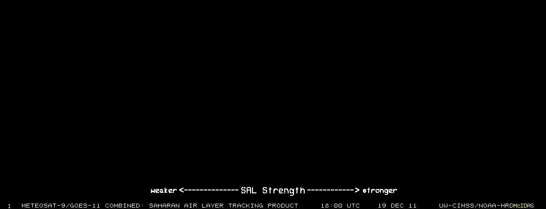
But we still have plenty of SAL
And GFS upward motion products look pretty darned unfavorable the next two weeks, at least.
Anyway, the Colombian heat low is soon to start fading somewhat as the Caribbean starts warming relative to South America, and the super-Easterlies should weaken some. Based on GFS initialization of 250 mb winds, shear should be lessening over much of the basin.
But we still have plenty of SAL
And GFS upward motion products look pretty darned unfavorable the next two weeks, at least.
0 likes
-
cycloneye
- Admin
- Posts: 149298
- Age: 69
- Joined: Thu Oct 10, 2002 10:54 am
- Location: San Juan, Puerto Rico
Re: Long / Medium Range Model Runs
Macrocane wrote:Leaving the Atlantic alone for a moment, have you seen what the models are predicting for the EPAC? they are in good agreement about development, it seems that the EPAC will turn active again in about 120-144 h, the Euro even shows a system in the CPAC.
For the most part,the models haved backed down on development in that basin.Only the EURO has something relativly strong.
0 likes
Re: Long / Medium Range Model Runs
cycloneye wrote:Macrocane wrote:Leaving the Atlantic alone for a moment, have you seen what the models are predicting for the EPAC? they are in good agreement about development, it seems that the EPAC will turn active again in about 120-144 h, the Euro even shows a system in the CPAC.
For the most part,the models haved backed down on development in that basin.Only the EURO has something relativly strong.
Yes, I've noticed that, it's a shame that even the Pacific has nothing interesting to track.
0 likes
-
Fego

- S2K Supporter
- Posts: 767
- Age: 66
- Joined: Sun Apr 18, 2004 7:58 pm
- Location: San Juan, Puerto Rico
- Contact:
Re: Long / Medium Range Model Runs
Our friends in the NWS in San Juan are kind of low in optimism about development conditions in the Atlantic... until the second half of august. Below is the latest Area Forecast Discussion.
AREA FORECAST DISCUSSION
NATIONAL WEATHER SERVICE SAN JUAN PR
348 PM AST TUE JUL 28 2009
......DISCUSSION
.....REALLY NOT MUCH TO TALK ABT IN THE TROPICS. SAHARAN
AIR LAYER CONTINUES TO AFFECT MUCH OF THE TROPICAL ATLC WITH ONE
CONCENTRATED AREA OF DUST/HAZE OVR THE NRN LEEWARD ISLES AND ANOTHER
ONE BETWEEN 25W AND 40W LONGITUDE BASED ON SAL ANALYSIS FROM CIMSS.
MODELS CONTINUE TO INDICATE A VERY DRY ATMS WITH A STRONG CAP IN
PLACE FOR TOMORROW SO AM ANTICIPATING PRETTY MUCH NOTHING JUST HAZE
AND WINDY CONDITIONS.
A TROPICAL WAVE ALONG 50W THIS AFTERNOON IS PROGGED TO PASS
MAINLY S OF THE AREA ON THU WITH SCT SHRA/TSRA EXPECTED BUT NOTHING
SIGNIFICANT. SEASONABLE WX FOR THE WEEKEND WITH ISOLD/SCT DIURNALLY
DRIVEN CONVECTION ACROSS THE WEST IN THE AFTERNOON AND ISOLD MORNING
SHRAS IN THE EAST BUT WITH A NOTICEABLE DROP IN WINDS.
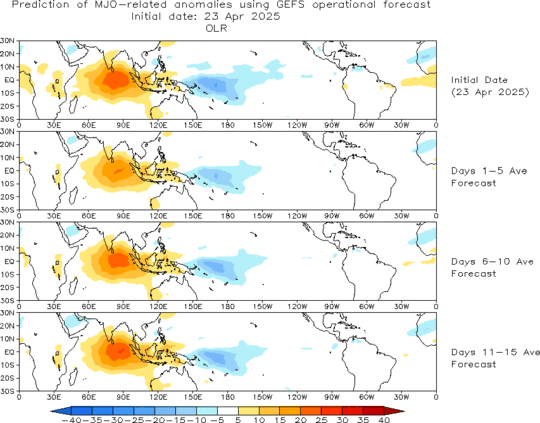
LATEST MJO PROGNOSIS FROM THE CPC WEB SITE CONTINUES TO INDICATE
STRONG DOWNWARD MOTION ACROSS THE ENTIRE ATLC BASIN THROUGH THE
MIDDLE OF AUGUST. SO IT APPEARS THE HURRICANE SEASON WILL CONTINUE
TO BE PUT ON HOLD.
0 likes
Who is online
Users browsing this forum: No registered users and 65 guests