SE TX/SW LA weather: Much cooler and WET after Tuesday
Moderator: S2k Moderators
Forum rules

The posts in this forum are NOT official forecast and should not be used as such. They are just the opinion of the poster and may or may not be backed by sound meteorological data. They are NOT endorsed by any professional institution or STORM2K.

Re: SE TX/SW LA weather: Summer Pattern-HOT!!!
It would be nice to have that storm cloud that is always over western Mexico at night over us for a change. That would give us a good and nice soaking rain. TRMM measures one week rainfall total of 20 inches! Satellite rainfall estimate often underestimates them. 


0 likes
-
southerngale

- Retired Staff

- Posts: 27418
- Joined: Thu Oct 10, 2002 1:27 am
- Location: Southeast Texas (Beaumont area)
Someone forgot to tell the skies that Tuesday was supposed to be the wettest day in a good while. Was there even a drop anywhere in SE TX? I saw a few clouds, but mostly just the hot sun, and nothing on radar when I was able to check. I didn't get anything on Monday, Tuesday's chances were even higher, and Wednesday's have dropped quite a bit. I think the models are playing dirty tricks on the forecasters. 
0 likes
-
Yankeegirl

- Category 5

- Posts: 3417
- Age: 50
- Joined: Sun May 23, 2004 11:59 pm
- Location: Cy-Fair, Northwest Houston
- Contact:
-
jasons2k

- Storm2k Executive

- Posts: 8290
- Age: 52
- Joined: Wed Jul 06, 2005 12:32 pm
- Location: The Woodlands, TX
Re:
HouTXmetro wrote:OT, can someone explain why the maps divide Texas into 3 and California into 2? Have we seceded or something? lol
http://www.storm2k.org/weather//images/ ... utlook.png
This is just a long-winded guess so I could be wrong:
Florida is divided too. It's just to divide-up such large geographic/climatic areas into smaller areas so that the outlook can be more accurate & specific. States such as California, Texas, & Florida are spread-out and span several different climate zones. The climate in Miami is quite a bit different than Pernsacola; Houston is dfifferent than Amarillo or El Paso; and so on. It's just broken into smaller areas to more closely match the size of most other states....
0 likes
-
HouTXmetro

- Category 5
- Posts: 3949
- Joined: Sun Jun 13, 2004 6:00 pm
- Location: District of Columbia, USA
Re: SE TX/SW LA weather: Summer Pattern-HOT!!!
I know but to have Houston, to Dallas and near Midland in the same area is a bit weired.
0 likes
-
Yankeegirl
- Category 5
- Posts: 3417
- Age: 50
- Joined: Sun May 23, 2004 11:59 pm
- Location: Cy-Fair, Northwest Houston
- Contact:
-
Ed Mahmoud
Re: SE TX/SW LA weather: Summer Pattern-HOT!!!
Dr. Norman on KHOU has 50% storm coverage with front just North of HOU area Friday.
20% higher than NWS. Latest NAM guidance seems a touch more optimistic on Friday rain chances.
New GFS looks to keep most precip just North and East of HOU area through Friday.
20% higher than NWS. Latest NAM guidance seems a touch more optimistic on Friday rain chances.
New GFS looks to keep most precip just North and East of HOU area through Friday.
0 likes
-
srainhoutx

- S2K Supporter

- Posts: 6919
- Age: 68
- Joined: Sun Jan 14, 2007 11:34 am
- Location: Haywood County, NC
- Contact:
Re: SE TX/SW LA weather: Summer Pattern-HOT!!!
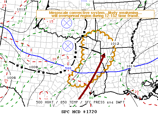
MESOSCALE DISCUSSION 1720
NWS STORM PREDICTION CENTER NORMAN OK
0640 AM CDT THU JUL 30 2009
AREAS AFFECTED...PARTS OF ERN TX INTO SW AR/NW LA
CONCERNING...SEVERE POTENTIAL...WATCH UNLIKELY
VALID 301140Z - 301315Z
THE SEVERE THREAT IS EXPECTED TO BECOME LOW ENOUGH TO ALLOW THE
CURRENT WW TO EXPIRE AS SCHEDULED AT 13Z. BUT...TRENDS WILL
CONTINUE TO BE MONITORED FOR AN INCREASING SEVERE THREAT AND THE
POSSIBILITY OF A WW LATER THIS MORNING.
LATEST OBSERVATIONAL DATA AND RUC MODEL GUIDANCE INDICATE A VERY
MOIST AIR MASS WITH WEAK TO MODERATE POTENTIAL INSTABILITY EXISTS
AHEAD OF THE LARGE MESOSCALE CONVECTIVE SYSTEM NOW ADVANCING EAST OF
THE INTERSTATE 35 CORRIDOR OF NORTHERN/CENTRAL TEXAS...THROUGH THE
SABINE VALLEY AND ARKLATEX REGION. COUPLED WITH THE APPARENT
PRESENCE OF A 30 KT SOUTHERLY 850 JET ACROSS UPPER TEXAS COASTAL
AREAS INTO FAR EASTERN TEXAS...THERE APPEARS TO BE AT LEAST SOME
POTENTIAL FOR AN INCREASING SEVERE THREAT THIS MORNING EAST OF WW
638. HOWEVER...GIVEN ANTICIPATED DIURNAL WEAKENING OF THE LOW-LEVEL
JET...AND THE PRESENCE OF LINGERING WEAK INHIBITION UNTIL SURFACE
HEATING INCREASES LATER THIS MORNING...THIS POTENTIAL APPEARS LOW IN
THE NEAR TERM...PARTICULARLY IN LIGHT OF STEADILY WARMING CLOUD TOPS
AND DIMINISHING TRENDS IN LIGHTNING DATA EVIDENT WITH THE ONGOING
STORM CLUSTER.
..KERR.. 07/30/2009
ATTN...WFO...LZK...LCH...SHV...HGX...FWD...
0 likes
-
srainhoutx
- S2K Supporter
- Posts: 6919
- Age: 68
- Joined: Sun Jan 14, 2007 11:34 am
- Location: Haywood County, NC
- Contact:
Re: SE TX/SW LA weather: Summer Pattern-HOT!!!
SPECIAL WEATHER STATEMENT
NATIONAL WEATHER SERVICE HOUSTON/GALVESTON TX
703 AM CDT THU JUL 30 2009
TXZ163-164-176-177-195>199-301400-
BRAZOS-BURLESON-GRIMES-HOUSTON-MADISON-MONTGOMERY-TRINITY-WALKER-
WASHINGTON-
703 AM CDT THU JUL 30 2009
...LINE OF STRONG THUNDERSTORMS MOVING SOUTHEAST AT 35 MPH...
AT 657 AM CDT...NATIONAL WEATHER SERVICE DOPPLER RADAR INDICATED A
LINE OF STRONG THUNDERSTORMS IN SOUTH CENTRAL TEXAS MOVING SOUTHEAST
AT 35 MPH TOWARD THE AREA. THESE STORMS WILL LIKELY BEGIN TO AFFECT
LOCATIONS BETWEEN CROCKETT...MADISONVILLE...AND CALDWELL BETWEEN 800
AND 900 AM CDT.
WINDS GREATER THAN 40 MPH...ARE POSSIBLE WITH THESE STORMS.
GUSTY WINDS MAY CAUSE UNSECURED SMALL OBJECTS SUCH AS TRASH CANS TO
BLOW AROUND. SEEK SHELTER IN A STURDY STRUCTURE OR NON-CONVERTABLE
AUTOMOBILE UNTIL THESE STORMS HAVE PASSED.
0 likes
-
srainhoutx
- S2K Supporter
- Posts: 6919
- Age: 68
- Joined: Sun Jan 14, 2007 11:34 am
- Location: Haywood County, NC
- Contact:
Re: SE TX/SW LA weather: Summer Pattern-HOT!!!
Another intersting disturbance with rapidly cooling cloud tops is developing near the Northern Hill Country further W than the current MCS to our N. Folks in the Austin area as well as those "locally" will need to keep an eye out as the day progresses for more chances for storms this afternoon/evening...
http://adds.aviationweather.noaa.gov/sa ... g&itype=ir
http://adds.aviationweather.noaa.gov/sa ... g&itype=ir
0 likes
Re: SE TX/SW LA weather: Summer Pattern-HOT!!!
I am hopeful as well.. I washed my truck this week, turned on the sprinklers this morning and promised the yard I would mow it today. All of that combined should hipefully do the trick!
0 likes

-
jasons2k
- Storm2k Executive
- Posts: 8290
- Age: 52
- Joined: Wed Jul 06, 2005 12:32 pm
- Location: The Woodlands, TX
Re: SE TX/SW LA weather: Summer Pattern-HOT!!!
AREA FORECAST DISCUSSION
NATIONAL WEATHER SERVICE HOUSTON/GALVESTON TX
920 AM CDT THU JUL 30 2009
.UPDATE...
FORECAST UPDATE FOR ONGOING CONVECTION.
&&
.DISCUSSION...
DECAYING MCS OVER MUCH OF N TX STRETCHES DOWN THROUGH THE PINEY
WOODS AND BRAZOS VALLEY THIS MORNING. INCREASED POPS MAINLY FOR
WHERE ONGOING CONVECTION EXISTS FROM CALDWELL TO CROCKETT. ALSO
INCREASED POPS FARTHER SOUTH WHICH IS THE BIG QUESTION MARK FOR
THE SHORT TERM FORECAST. JUST HOW FAR WILL THIS LINE OF STORMS
PROGRESS INTO SE TX? RIGHT NOW THINK OUTFLOW AND SOME STORMS MAY
SHOVE AT LEAST THROUGH KCXO POSSIBLY INTO THE HOUSTON METRO AREA.
NONE OF THE MODELS ARE HANDLING THIS SITUATION WELL SO STUCK 40
POPS IN FOR THIS AFTERNOON ACROSS MUCH OF THE AREA NORTH OF I-10.
THIS IS MAINLY TO COVER THE CHANCE OF POSSIBLE THUNDERSTORM
ACTIVITY THAT DEVELOPS LATER THIS AFTERNOON ALONG ANY OUTFLOW
BOUNDARIES THAT DO HANG AROUND THE AREA. MAX TEMPS WERE ADJUSTED
DOWN A FEW DEGREES AS CLOUD COVER AND OUTFLOW FROM STORMS MAY AT
LEAST HOLD DOWN TEMPS IN THE MID 90S FOR THE NORTHERN HALF OF THE
CWA. AREAS OFF TO THE SW TOWARDS KARM COULD STILL SEE UPPER 90S.
LATEST FORECAST UPDATE HAS BEEN SENT.
0 likes
-
srainhoutx
- S2K Supporter
- Posts: 6919
- Age: 68
- Joined: Sun Jan 14, 2007 11:34 am
- Location: Haywood County, NC
- Contact:
-
Yankeegirl
- Category 5
- Posts: 3417
- Age: 50
- Joined: Sun May 23, 2004 11:59 pm
- Location: Cy-Fair, Northwest Houston
- Contact:

-
srainhoutx
- S2K Supporter
- Posts: 6919
- Age: 68
- Joined: Sun Jan 14, 2007 11:34 am
- Location: Haywood County, NC
- Contact:
Re: SE TX/SW LA weather: Summer Pattern-HOT!!!
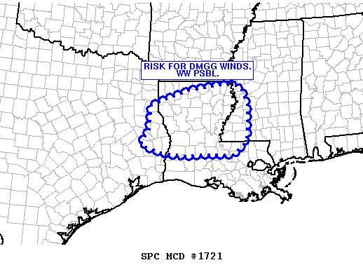
MESOSCALE DISCUSSION 1721
NWS STORM PREDICTION CENTER NORMAN OK
1012 AM CDT THU JUL 30 2009
AREAS AFFECTED...ECNTRL TX...NRN/CNTRL LA AND WCNTRL MS
CONCERNING...SEVERE POTENTIAL...WATCH POSSIBLE
VALID 301512Z - 301715Z
REMNANT FORWARD FLANK OF NOCTURNAL MCS WAS ATTEMPTING TO INTENSIFY
OVER FAR ECNTRL TX AS A SMALL LINE SEGMENT. DOWNSTREAM AIR MASS
WILL MODESTLY HEAT THROUGH THE AFTN GIVEN BREAKS IN MID/HIGH CLOUDS.
IN FACT...MODIFICATION OF 12Z SOUNDINGS ALREADY SUGGESTS 2000-2500
J/KG OF MLCAPE AND MINIMAL MLCINH. FORCING ASSOCD WITH THE
MCV...VERY MOIST AIR MASS IN PLACE AND CONTINUED DESTABILIZATION OF
THE BOUNDARY LAYER WILL CONTRIBUTE TO BOTH A FURTHER INTENSIFICATION
OF THE LINE AND THE ISOLD CELLS DEVELOPING AHEAD OF IT.
UPSTREAM VWP/PROFILERS SAMPLED ABOUT 40-50 KTS OF FLOW ABOVE H85 IN
WAKE OF THE MCV AND GIVEN THE MAINTENANCE OF A 30 KT H925-H85 SLY
LLJ AHEAD OF THE FEATURE...ADDITIONAL STORM ORGANIZATION CAN BE
EXPECTED. PRIMARY THREAT WILL BE DMGG WINDS...ESPECIALLY GIVEN
HINTS OF RELATIVELY DRY AIR BETWEEN H85-H7 ON MORNING SOUNDINGS AND
POTENTIAL FOR EVAPORATIVE COOLING. BUT...AN ISOLD SUPERCELL /BRIEF
TORNADO/ CANNOT BE RULED OUT...ESPECIALLY AS THE STORMS INTERACT
WITH THE WRMFNT DRAPED EWD ACROSS NRN LA/WCNTRL MS OR WITH ANY CELLS
DEVELOPING AND/OR MERGING WITH THE LINE.
..RACY.. 07/30/2009
ATTN...WFO...JAN...LIX...LCH...SHV...HGX...
0 likes
-
srainhoutx
- S2K Supporter
- Posts: 6919
- Age: 68
- Joined: Sun Jan 14, 2007 11:34 am
- Location: Haywood County, NC
- Contact:
Re: SE TX/SW LA weather: Summer Pattern-HOT!!!
E-mail from Jeff Lindner...
Active N TX convection making good headway into SE TX this morning.
Weakening MCS located along and line from near Brenham to S of Huntsville moving S at 10mph. Cloud tops are warming on IR images so the MCS is in its weakening phase and will likely fall apart as it approaches a line from Cypress to Conroe. Ahead of the complex warm air advection pattern is resulting in scattered showers developing mainly NE of a line from Brenham to Downtown Houston to Galveston. Expect resultant outflow boundary from N counties convection coupled with increasing low level flow and heating to continue to fire scattered convection through the mid afternoon. Most favored areas will be along and E of I-45 and little to no activity west of a line from Columbus to Bay City…or in the area of historical drought.
May see another similar event on Friday before ridging aloft return to the area for the weekend. Will likely see highs increase toward 100 over the weekend and heat index values approach advsiory criteria.
0 likes
-
vbhoutex

- Storm2k Executive
- Posts: 29149
- Age: 74
- Joined: Wed Oct 09, 2002 11:31 pm
- Location: Cypress, TX
- Contact:
Re: SE TX/SW LA weather: Summer Pattern-HOT!!!
I open up this after talking with relatives in Lee's Summit, MO this morning with them telling me it was 60ºf at their house.srainhoutx wrote:E-mail from Jeff Lindner...Active N TX convection making good headway into SE TX this morning.
Weakening MCS located along and line from near Brenham to S of Huntsville moving S at 10mph. Cloud tops are warming on IR images so the MCS is in its weakening phase and will likely fall apart as it approaches a line from Cypress to Conroe. Ahead of the complex warm air advection pattern is resulting in scattered showers developing mainly NE of a line from Brenham to Downtown Houston to Galveston. Expect resultant outflow boundary from N counties convection coupled with increasing low level flow and heating to continue to fire scattered convection through the mid afternoon. Most favored areas will be along and E of I-45 and little to no activity west of a line from Columbus to Bay City…or in the area of historical drought.
May see another similar event on Friday before ridging aloft return to the area for the weekend. Will likely see highs increase toward 100 over the weekend and heat index values approach advsiory criteria.
0 likes
Return to “USA & Caribbean Weather”
Who is online
Users browsing this forum: Cpv17, WeatherNewbie and 83 guests