Global model runs discussion
Moderator: S2k Moderators
-
gatorcane

- S2K Supporter

- Posts: 23708
- Age: 48
- Joined: Sun Mar 13, 2005 3:54 pm
- Location: Boca Raton, FL
I think the models are banking on some pretty strong wind shear from the WSW near the Caribbean. That is what CIMSS is showing at the moment. But a week from now when the wave gets closer, that shear may not be as strong or it may still be there. I think that is why the models are weakening the area towards the end, because they are thinking the wind shear will still be there. Wind shear is pretty tough for the models to forecast, especially 7-10 days out so lets see some trends as this week progresses.
0 likes
-
Ed Mahmoud
Re: Long / Medium Range Model Runs
I think Euro is showing a weak surface reflection near San Martin of the current wave leaving Africa.
Not strong, but no "colors", ie, 850 mb winds below 30 knots in the Caribbean, meaning less shear and less low level divergence.
Day 6, yellow color, >30 knot low level flow

Day 9, wave near NE Lesser Antilles, no screaming Easterlies in the Caribbean.

Ok, not exactly a positive (actually, negative) forecast from the ensembles, but the negative (for development) OLR anamolies start to disappear beyond Day 6...
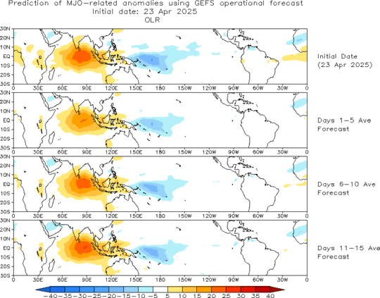
Not strong, but no "colors", ie, 850 mb winds below 30 knots in the Caribbean, meaning less shear and less low level divergence.
Day 6, yellow color, >30 knot low level flow
Day 9, wave near NE Lesser Antilles, no screaming Easterlies in the Caribbean.
Ok, not exactly a positive (actually, negative) forecast from the ensembles, but the negative (for development) OLR anamolies start to disappear beyond Day 6...
0 likes
-
Ed Mahmoud
Re: Long / Medium Range Model Runs
Bed time approaches- GFS- close to a depression in less than 3 days...

An Equatorward outflow jet developing?

700 mb air not too dry, anyway...

700 mb and 500 mb wind flow would suggest West (or I guess maybe WNW with Beta) direction, at least at 66 hours.
66 hour looped surface suggests W-NW travel, surface high to the North barely shifts Eastward during the 66 hours, looping 500 mb heights/winds through 60 hours shows East Coast trough advancing slowly Eastward, and by 66 hours 500 mb flow off L. Antilles from the ESE to SE, suggesting (but awfully hard to be certain with 66 hours of the model run, which may not be completely accurate to begin with) the islands could be safe, this could be a fish storm.
Just speculating, at this point.
But maybe the first real shot at something during El Nino 2009.
ETA
96 hours- no stronger, moving between WNW and NW, East Coast trough has flattened a tad, 500 mb winds East of the islands are back to generally from the East, but this is already up to ballpark 15ºN just past 40ºW, so I'm still thinking it more than likely misses the island, but it isn't a solid lock. For that matter, it may not even develop as much as GFS (strong wave, maybe a depression) suggests.
But we're into a less than one week time frame on suggested development. Oh, GFS seems to like next wave in line still over Africa, nearing coast in 4 days.
An Equatorward outflow jet developing?
700 mb air not too dry, anyway...
700 mb and 500 mb wind flow would suggest West (or I guess maybe WNW with Beta) direction, at least at 66 hours.
66 hour looped surface suggests W-NW travel, surface high to the North barely shifts Eastward during the 66 hours, looping 500 mb heights/winds through 60 hours shows East Coast trough advancing slowly Eastward, and by 66 hours 500 mb flow off L. Antilles from the ESE to SE, suggesting (but awfully hard to be certain with 66 hours of the model run, which may not be completely accurate to begin with) the islands could be safe, this could be a fish storm.
Just speculating, at this point.
But maybe the first real shot at something during El Nino 2009.
ETA
96 hours- no stronger, moving between WNW and NW, East Coast trough has flattened a tad, 500 mb winds East of the islands are back to generally from the East, but this is already up to ballpark 15ºN just past 40ºW, so I'm still thinking it more than likely misses the island, but it isn't a solid lock. For that matter, it may not even develop as much as GFS (strong wave, maybe a depression) suggests.
But we're into a less than one week time frame on suggested development. Oh, GFS seems to like next wave in line still over Africa, nearing coast in 4 days.
0 likes
-
cycloneye

- Admin

- Posts: 149525
- Age: 69
- Joined: Thu Oct 10, 2002 10:54 am
- Location: San Juan, Puerto Rico
Re: Long / Medium Range Model Runs
In the 00z runs of the models CMC is the most strongest of them and tracks it almost to the east of Guadeloupe.
http://moe.met.fsu.edu/cgi-bin/cmctc2.c ... =Animation

http://moe.met.fsu.edu/cgi-bin/cmctc2.c ... =Animation
0 likes
-
Ed Mahmoud
Re: Long / Medium Range Model Runs
Canadian at 180 - squeaks by Puerto Rico (barely), may catch BVI and USVI, possible East Coast risk. Or maybe not.

0 likes
-
gatorcane
- S2K Supporter
- Posts: 23708
- Age: 48
- Joined: Sun Mar 13, 2005 3:54 pm
- Location: Boca Raton, FL
Re: Long / Medium Range Model Runs
00Z ECMWF moves the wave west not developing it, but keeps it at a low lattitude across the MDR. Interesting that the 6Z GFS keeps the wave headed more west on this run, through the Southern Leewards into the Caribbean (no NW motion towards the end that the 00Z GFS was showing):
GFS 00Z:
http://moe.met.fsu.edu/cgi-bin/gfstc2.c ... =Animation
GFS 06Z:
http://moe.met.fsu.edu/cgi-bin/gfstc2.c ... =Animation
GFS 00Z:
http://moe.met.fsu.edu/cgi-bin/gfstc2.c ... =Animation
GFS 06Z:
http://moe.met.fsu.edu/cgi-bin/gfstc2.c ... =Animation
0 likes
-
Gustywind

- Category 5

- Posts: 12334
- Joined: Mon Sep 03, 2007 7:29 am
- Location: Baie-Mahault, GUADELOUPE
Re: Long / Medium Range Model Runs
cycloneye wrote:In the 00z runs of the models CMC is the most strongest of them and tracks it almost to the east of Guadeloupe.
http://moe.met.fsu.edu/cgi-bin/cmctc2.c ... =Animation
0 likes
-
cycloneye
- Admin
- Posts: 149525
- Age: 69
- Joined: Thu Oct 10, 2002 10:54 am
- Location: San Juan, Puerto Rico
Re: Long / Medium Range Model Runs
Make it two runs in a row Gusty. 
12z CMC has the same track as the 00z run.
http://moe.met.fsu.edu/cgi-bin/cmctc2.c ... =Animation
12z CMC has the same track as the 00z run.
http://moe.met.fsu.edu/cgi-bin/cmctc2.c ... =Animation
0 likes
-
Ed Mahmoud
Re: Long / Medium Range Model Runs
cycloneye wrote:Make it two runs in a row Gusty.
12z CMC has the same track as the 00z run.
http://moe.met.fsu.edu/cgi-bin/cmctc2.c ... =Animation
That looks more like it is headed for the USVI/BVI/Puerto Rico than Guadeloupe...
0 likes
-
Gustywind
- Category 5
- Posts: 12334
- Joined: Mon Sep 03, 2007 7:29 am
- Location: Baie-Mahault, GUADELOUPE
Re: Long / Medium Range Model Runs
Ed Mahmoud wrote:cycloneye wrote:Make it two runs in a row Gusty.
12z CMC has the same track as the 00z run.
http://moe.met.fsu.edu/cgi-bin/cmctc2.c ... =Animation
That looks more like it is headed for the USVI/BVI/Puerto Rico than Guadeloupe...
Humm you're kind...but Ed Mahmoud
0 likes
-
Gustywind
- Category 5
- Posts: 12334
- Joined: Mon Sep 03, 2007 7:29 am
- Location: Baie-Mahault, GUADELOUPE
Re: Long / Medium Range Model Runs
cycloneye wrote:Make it two runs in a row Gusty.
12z CMC has the same track as the 00z run.
http://moe.met.fsu.edu/cgi-bin/cmctc2.c ... =Animation
It's another joke Cycloneye

0 likes
-
Ed Mahmoud
Re: Long / Medium Range Model Runs
IF the Canadian is correct...
The slight positive tilt trough passing by to the North weakens the ridge just North of Puerto Rico to possibly begin to recurve the potential future Ana. Maybe.
But it looks like a close call, and it could just deflect Ana somewhat Northward, before the ridge builds over, and we have a Hurricane Andrew type system approaching from the Bahamas.

Or, maybe not at all.
The slight positive tilt trough passing by to the North weakens the ridge just North of Puerto Rico to possibly begin to recurve the potential future Ana. Maybe.
But it looks like a close call, and it could just deflect Ana somewhat Northward, before the ridge builds over, and we have a Hurricane Andrew type system approaching from the Bahamas.
Or, maybe not at all.
0 likes
-
wxman57

- Moderator-Pro Met

- Posts: 23175
- Age: 68
- Joined: Sat Jun 21, 2003 8:06 pm
- Location: Houston, TX (southwest)
Re: Long / Medium Range Model Runs
Nothing significant through August 19th on the 12Z GFS run. Just a couple weak lows near Africa that die out farther west.
0 likes
-
Ed Mahmoud
Re: Long / Medium Range Model Runs
wxman57 wrote:Nothing significant through August 19th on the 12Z GFS run. Just a couple weak lows near Africa that die out farther west.
GFS is flip-flopping. Had a TD in 3 days on the 0Z run. Splashing and flooping like a fish in a puddle on the bottom of a rowboat.
Last nights JMA had a strong wave approaching the islands in 8 days. Still want to see Euro and NoGaps, to see if my strained interpretation of the 144 hour Canadian implying a Florida threat has any chance at all, no matter how remote.
0 likes
-
Ed Mahmoud
Re: Long / Medium Range Model Runs
Ok, for serious model fun- DGEX closes off a low just East of Florida, drifts it Northwest, then turns it around and hits Florida with it.


0 likes
-
SEASON_CANCELED

- Category 3

- Posts: 887
- Joined: Mon Jul 06, 2009 5:17 am
- Location: 8 Bit Charlie Sheen
Re: Long / Medium Range Model Runs
Ed Mahmoud wrote:IF the Canadian is correct...
Or, maybe not at all.
I couldnt tell if that was andrew or Katrina if it wasnt for you pointing it out. How sad is that. andrew use to be the gold standard for destructive hurricanes and after the last 6 years of carnage its nothing more than a footnote in storm history.Amazing. Really if you think about it. The hurricanes of 20 years ago. Floyd, Bob, Hugo, Andrew. Hardly even talked about anymore for there destructive power.
I was 8 and lived in Fort Myers when andrew came through.it was wicked even without a direct hit. My dad was in miami when it hit and stayed in a hotel with some cameramen who went to coconut grove to chase the storm. The footage is on youtube.
http://www.youtube.com/watch?v=PFps53Yj9a0
Sorry for the derail/back to models
0 likes
-
cycloneye
- Admin
- Posts: 149525
- Age: 69
- Joined: Thu Oct 10, 2002 10:54 am
- Location: San Juan, Puerto Rico
Re: Long / Medium Range Model Runs
The 12z ECMWF has nothing new in this run,the same small L with a small circle only for 72 hours.
12z ECMWF
12z ECMWF
0 likes
-
cycloneye
- Admin
- Posts: 149525
- Age: 69
- Joined: Thu Oct 10, 2002 10:54 am
- Location: San Juan, Puerto Rico
Re: Long / Medium Range Model Runs
If you believe the long range after 200 hours,according to 18z GFS,it redevelops it near Bermuda,after it develops it first in the short range east of the Leewards.
http://www.nco.ncep.noaa.gov/pmb/nwprod ... loop.shtml


http://www.nco.ncep.noaa.gov/pmb/nwprod ... loop.shtml
0 likes
Re: Long / Medium Range Model Runs
Model runs suggest our first 'fish' before long...but what is that in the florida straits....let's look for consistency across models and subsequent runs to see if this is legit or just noise

0 likes
Who is online
Users browsing this forum: No registered users and 8 guests