Disturbance fizzeled in Eastern Atlantic

This is the general tropical discussion area. Anyone can take their shot at predicting a storms path.

Moderator: S2k Moderators

Forum rules

The posts in this forum are NOT official forecasts and should not be used as such. They are just the opinion of the poster and may or may not be backed by sound meteorological data. They are NOT endorsed by any professional institution or STORM2K. For official information, please refer to products from the National Hurricane Center and National Weather Service.

Help Support Storm2K
Message
Author
User avatar
Category 5
Category 5
Category 5
Posts: 10074
Age: 35
Joined: Sun Feb 11, 2007 10:00 pm
Location: New Brunswick, NJ
Contact:

Re:

#201 Postby Category 5 » Mon Aug 03, 2009 8:39 pm

RL3AO wrote:Image


:roflmao:

I need a new monitor.
0 likes   

User avatar
Gustywind
Category 5
Category 5
Posts: 12334
Joined: Mon Sep 03, 2007 7:29 am
Location: Baie-Mahault, GUADELOUPE

#202 Postby Gustywind » Mon Aug 03, 2009 8:47 pm

Image
0 likes   

User avatar
cycloneye
Admin
Admin
Posts: 143883
Age: 68
Joined: Thu Oct 10, 2002 10:54 am
Location: San Juan, Puerto Rico

Re: Strong wave in Eastern Atlantic

#203 Postby cycloneye » Mon Aug 03, 2009 8:48 pm

If this persists for the next 12 hours,I will not be surprised if it gets invest status.Finnally,I can lock the thread if that happens. :)

If it not gets invest status,it will die down the pages as soon is not anymore in the charts. :)

Sidebar=At title,I took out the word wave and put disturbance.
0 likes   

User avatar
Gustywind
Category 5
Category 5
Posts: 12334
Joined: Mon Sep 03, 2007 7:29 am
Location: Baie-Mahault, GUADELOUPE

#204 Postby Gustywind » Mon Aug 03, 2009 9:06 pm

Looking better and better, convection is expanding, nice sat appareance...
Image
0 likes   

User avatar
gatorcane
S2K Supporter
S2K Supporter
Posts: 23689
Age: 47
Joined: Sun Mar 13, 2005 3:54 pm
Location: Boca Raton, FL

#205 Postby gatorcane » Mon Aug 03, 2009 9:12 pm

The moisture envelope surrounding the disturbance is quite moist as well. SAL is more north and is not greatly impacting this system. Shear is light out of the east...

Image
Last edited by gatorcane on Mon Aug 03, 2009 9:13 pm, edited 2 times in total.
0 likes   

User avatar
Blown Away
S2K Supporter
S2K Supporter
Posts: 10140
Joined: Wed May 26, 2004 6:17 am

Re:

#206 Postby Blown Away » Mon Aug 03, 2009 9:31 pm

RL3AO wrote:Image


If the convection persists tonight, gentlemen's bet the NHC places the Yellow polygon around the convection ball tomorrow! :D
0 likes   

User avatar
Category 5
Category 5
Category 5
Posts: 10074
Age: 35
Joined: Sun Feb 11, 2007 10:00 pm
Location: New Brunswick, NJ
Contact:

Re: Large wave emerging from West Africa

#207 Postby Category 5 » Mon Aug 03, 2009 9:33 pm

Ed Mahmoud wrote:My amateur and unofficial prediction:


Poofation.


Nice going Ed, It'll be a cat 5 by sunrise. :wink:
0 likes   

User avatar
Gustywind
Category 5
Category 5
Posts: 12334
Joined: Mon Sep 03, 2007 7:29 am
Location: Baie-Mahault, GUADELOUPE

Re:

#208 Postby Gustywind » Mon Aug 03, 2009 9:33 pm

gatorcane wrote:The moisture envelope surrounding the disturbance is quite moist as well. SAL is more north and is not greatly impacting this system. Shear is light out of the east...

Image

Yeah, right Gatorcane and look at the ITCZ ahead...bringing with my untrained eyes another moist support for this thing to pop. This strong wave continues to exhibit a very nice sat appareance. A window of opportunity is maybe trying to open, let's wait and see the 12 next hours.
0 likes   

User avatar
GeneratorPower
S2K Supporter
S2K Supporter
Posts: 1648
Age: 45
Joined: Sun Dec 18, 2005 11:48 pm
Location: Huntsville, AL

#209 Postby GeneratorPower » Mon Aug 03, 2009 9:34 pm

Large thunderstorm complex in the MDR in August. Definately worthy of inspection on these facts alone.
0 likes   

User avatar
Ivanhater
Storm2k Moderator
Storm2k Moderator
Posts: 11153
Age: 38
Joined: Fri Jul 01, 2005 8:25 am
Location: Pensacola

Re: Strong Disturbance in Eastern Atlantic

#210 Postby Ivanhater » Mon Aug 03, 2009 9:44 pm

--Well convection has grown all day, which should lower pressure. Interesting to say the least which some model support. In any case, something to watch :D
0 likes   

User avatar
SEASON_CANCELED
Category 3
Category 3
Posts: 887
Joined: Mon Jul 06, 2009 5:17 am
Location: 8 Bit Charlie Sheen

Re: Strong Disturbance in Eastern Atlantic

#211 Postby SEASON_CANCELED » Mon Aug 03, 2009 9:46 pm

looking quite impressive. :eek: I wonder if we will have an invest in the AM. But the area in front is pretty dry. lets see.
0 likes   

User avatar
SEASON_CANCELED
Category 3
Category 3
Posts: 887
Joined: Mon Jul 06, 2009 5:17 am
Location: 8 Bit Charlie Sheen

Re: Strong Disturbance in Eastern Atlantic

#212 Postby SEASON_CANCELED » Mon Aug 03, 2009 9:48 pm

Definate cyclonic turning as of 10:45pm on the GOES imagery :eek: But at what levels who knows. Definately not surface. just looks pretty healthy as of right now. Think we get a yellow box tommorrow
0 likes   

User avatar
Blown Away
S2K Supporter
S2K Supporter
Posts: 10140
Joined: Wed May 26, 2004 6:17 am

Re: Strong Disturbance in Eastern Atlantic

#213 Postby Blown Away » Mon Aug 03, 2009 9:52 pm

It may end up as a poofer, but looking at the wide view IR loop, talk about great satellite presentation.
http://www.ssd.noaa.gov/goes/east/tatl/loop-avn.html
0 likes   

User avatar
SEASON_CANCELED
Category 3
Category 3
Posts: 887
Joined: Mon Jul 06, 2009 5:17 am
Location: 8 Bit Charlie Sheen

Re: Strong Disturbance in Eastern Atlantic

#214 Postby SEASON_CANCELED » Mon Aug 03, 2009 9:56 pm

Blown_away wrote:It may end up as a poofer, but looking at the wide view IR loop, talk about great satellite presentation.
http://www.ssd.noaa.gov/goes/east/tatl/loop-avn.html


Yup most of the models show either poofation or fishing. Nothing conculsive. I think tommorrow at sunrise we will have a better idea. its still really far out but Cape Verde season has started. Its looks like typical Cape Verde Cyclogenesis but dunno. let the promets opine while i lurk
0 likes   

HurricaneJoe22
Category 1
Category 1
Posts: 456
Joined: Wed Sep 08, 2004 12:45 am
Location: Temple, Texas

#215 Postby HurricaneJoe22 » Mon Aug 03, 2009 10:05 pm

We've been burned time and time again by pretty balls of convection. Derek says this isn't likely to develop and he should know. Just cause it's pretty doesn't mean it will develop into a tropical cyclone. Unless Derek is interested in it, why should we think otherwise?
0 likes   

User avatar
HURAKAN
Professional-Met
Professional-Met
Posts: 46086
Age: 38
Joined: Thu May 20, 2004 4:34 pm
Location: Key West, FL
Contact:

Re: Strong Disturbance in Eastern Atlantic

#216 Postby HURAKAN » Mon Aug 03, 2009 10:09 pm

Image

At least there's something to watch
0 likes   

User avatar
Ivanhater
Storm2k Moderator
Storm2k Moderator
Posts: 11153
Age: 38
Joined: Fri Jul 01, 2005 8:25 am
Location: Pensacola

Re: Strong Disturbance in Eastern Atlantic

#217 Postby Ivanhater » Mon Aug 03, 2009 10:12 pm

Image
0 likes   

User avatar
cycloneye
Admin
Admin
Posts: 143883
Age: 68
Joined: Thu Oct 10, 2002 10:54 am
Location: San Juan, Puerto Rico

Re: Strong Disturbance in Eastern Atlantic

#218 Postby cycloneye » Mon Aug 03, 2009 10:15 pm

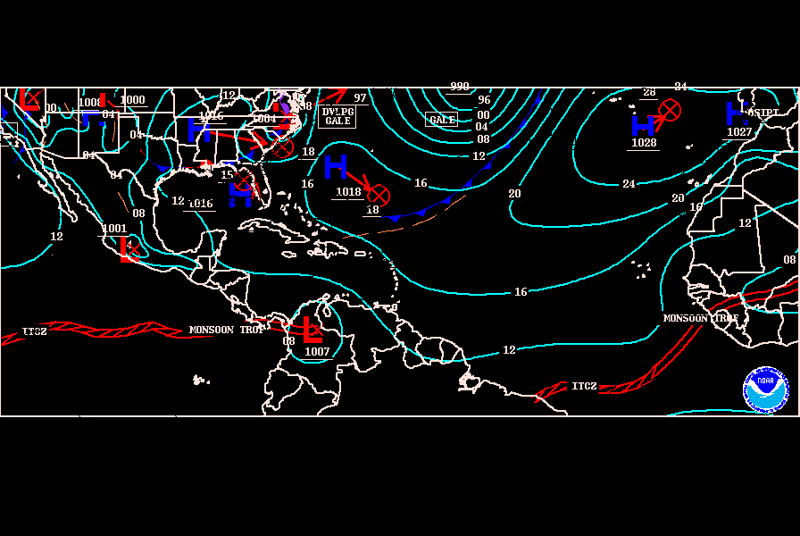
Surface trough has been added to this feature at the 00:00 UTC surface analysis chart.

Image
0 likes   

User avatar
Macrocane
Category 5
Category 5
Posts: 4218
Age: 36
Joined: Sun May 24, 2009 5:35 pm
Location: El Salvador

Re: Strong Disturbance in Eastern Atlantic

#219 Postby Macrocane » Mon Aug 03, 2009 10:28 pm

If we are going to talk about it please call it "the trough" and not "the wave" :wink:
0 likes   

User avatar
Kludge
S2K Supporter
S2K Supporter
Posts: 215
Joined: Thu Aug 26, 2004 9:03 pm
Location: Bedias, Texas

Re: Large wave emerging from West Africa

#220 Postby Kludge » Mon Aug 03, 2009 10:30 pm

Category 5 wrote:
Ed Mahmoud wrote:My amateur and unofficial prediction:


Poofation.


Nice going Ed, It'll be a cat 5 by sunrise. :wink:


Today = 8/3. WxMan57 predicts Anna on 8/5. This represents the best chance of Anna in the next 2 days. Since WxMan must be right, then this is 48 hours from a storm (just working the logic angle here).

Finally something to watch.

That is, other than the Canadian at 144 hours. :lol:
0 likes   


Return to “Talkin' Tropics”

Who is online

Users browsing this forum: duilaslol, hcane27 and 178 guests