ATL: TROPICAL DEPRESSION ANA (02L)

Moderator: S2k Moderators

Message
Author
User avatar
wxman57
Moderator-Pro Met
Moderator-Pro Met
Posts: 22951
Age: 67
Joined: Sat Jun 21, 2003 8:06 pm
Location: Houston, TX (southwest)

Re: ATL : INVEST 99L

#121 Postby wxman57 » Sun Aug 09, 2009 2:42 pm

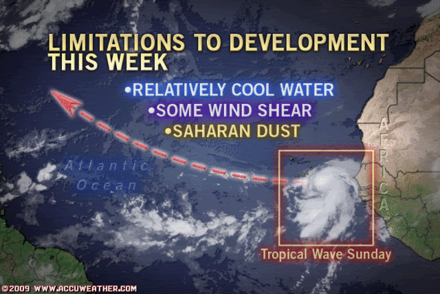
Nimbus wrote:Do you suppose the NHC is waiting to upgrade this to a TD because they want to get a better handle on the future track? The last wave that came off Africa looked quite impressive at this longitude but it went poof once it got a little further west. This wave seems to have a little stronger pulse and more moisture to work with. The models will do a better job if they have been initialized with a clear LLC position and with a longer history of the strengthening/weakening trend.


No, there's no rush as far as the NHC is concerned. It's a long way from any of its interests. A number of systems look like this near Africa, only to fall apart within 24 hrs. This looks like a TD now.
0 likes   

User avatar
cycloneye
Admin
Admin
Posts: 143867
Age: 68
Joined: Thu Oct 10, 2002 10:54 am
Location: San Juan, Puerto Rico

Re: ATL : INVEST 99L

#122 Postby cycloneye » Sun Aug 09, 2009 2:45 pm

Surely is 57. Last visible image.

Image
0 likes   

User avatar
wx247
S2K Supporter
S2K Supporter
Posts: 14279
Age: 41
Joined: Wed Feb 05, 2003 10:35 pm
Location: Monett, Missouri
Contact:

#123 Postby wx247 » Sun Aug 09, 2009 2:50 pm

That looks impressive Luis. Thanks for sharing!
0 likes   

jinftl
Category 5
Category 5
Posts: 4312
Joined: Tue Aug 31, 2004 4:47 pm
Location: fort lauderdale, fl

Re: ATL : INVEST 99L

#124 Postby jinftl » Sun Aug 09, 2009 2:56 pm

Appears to have some banding features

Image
0 likes   

jinftl
Category 5
Category 5
Posts: 4312
Joined: Tue Aug 31, 2004 4:47 pm
Location: fort lauderdale, fl

Re: ATL: Invest 99L Models

#125 Postby jinftl » Sun Aug 09, 2009 3:00 pm

Several models show Ana being born (or coming very very close - 35kts = 40mph) in the next 12-24 hours, strengthening/maintaining, and then possibly weakening in a few days....that could be interesting in terms of track implications

Image
0 likes   

User avatar
KWT
Category 5
Category 5
Posts: 31415
Joined: Tue Aug 17, 2004 11:02 am
Location: UK!!!

#126 Postby KWT » Sun Aug 09, 2009 3:07 pm

I think it won't be long before we hear the NHC mention a tropical depression could form in today or tomorrow, red alert next time round surely!

As wxman57 said, it looks like a TD now.
0 likes   

jinftl
Category 5
Category 5
Posts: 4312
Joined: Tue Aug 31, 2004 4:47 pm
Location: fort lauderdale, fl

Re: ATL: Invest 99L Models

#127 Postby jinftl » Sun Aug 09, 2009 3:09 pm

Latest model runs do shift west....compare 2pm tuns to earlier run posted in prior post (8am runs)

Image
0 likes   

User avatar
vacanechaser
Category 5
Category 5
Posts: 1461
Joined: Wed Dec 03, 2003 9:34 pm
Location: Portsmouth, Va
Contact:

Re: ATL : INVEST 99L

#128 Postby vacanechaser » Sun Aug 09, 2009 3:17 pm

cycloneye wrote:Surely is 57. Last visible image.

Image


looks like a nice little bomb going off... it really looks like a t.d at this point...


Jesse V. Bass III
http://www.vastormphoto.com
Hurricane Intercept Research Team
0 likes   

jinftl
Category 5
Category 5
Posts: 4312
Joined: Tue Aug 31, 2004 4:47 pm
Location: fort lauderdale, fl

Re: ATL : INVEST 99L

#129 Postby jinftl » Sun Aug 09, 2009 3:17 pm

Wunderground graphic shows 99L with sustained winds of 30mph

Image
0 likes   

User avatar
gatorcane
S2K Supporter
S2K Supporter
Posts: 23689
Age: 47
Joined: Sun Mar 13, 2005 3:54 pm
Location: Boca Raton, FL

#130 Postby gatorcane » Sun Aug 09, 2009 3:44 pm

Both the UKMET and ECMWF show good heights across the entire Atlantic at least up through 192 hours where a trough enters the picture in the Central Atlantic. No reason why 99L goes West or WNW for the next week or so...the pattern is zonal across the atlantic.

The real concern for me is the wave behind 99L which will likely be able to take advantage of those heights to track pretty far west. GFS and ECMWF bring that wave behind 99L very far west with significant development (by the GFS). No doubt that Cape Verde season is kicking off with a bang and that switch that I have been mentioning is about to turn on in the Atlantic about on schedule.

UKMET heights:
http://weather.uwyo.edu/cgi-bin/model?M ... t&VEC=none
0 likes   

Aric Dunn
Category 5
Category 5
Posts: 21238
Age: 42
Joined: Sun Sep 19, 2004 9:58 pm
Location: Ready for the Chase.
Contact:

#131 Postby Aric Dunn » Sun Aug 09, 2009 3:47 pm

that linear convergence band that was attached to the system has begun to wrap around to the south .. I would say its a very close to being a depression. by definition if it has a closed surface circ and at least some convection it is a depression .. it appears we do have a surface circulation forming quite fast.
0 likes   

User avatar
gatorcane
S2K Supporter
S2K Supporter
Posts: 23689
Age: 47
Joined: Sun Mar 13, 2005 3:54 pm
Location: Boca Raton, FL

#132 Postby gatorcane » Sun Aug 09, 2009 3:55 pm

Models are also jumping strongly on that wave east of 99L in Africa (even the ECMWF likes this wave) which appears to be a westrunner. It looks like it really could be our next invest so I started a thread where we can discuss:

viewtopic.php?f=31&t=106112
0 likes   

User avatar
PTrackerLA
Category 5
Category 5
Posts: 5276
Age: 41
Joined: Thu Oct 10, 2002 8:40 pm
Location: Lafayette, LA

Re: ATL : INVEST 99L

#133 Postby PTrackerLA » Sun Aug 09, 2009 4:30 pm

Looks excellent on satellite still with bursting convection seen in that last visible shot. Would be surprised if this is not upgraded to a TD by tomorrow. Welcome to the season everyone!
0 likes   

jinftl
Category 5
Category 5
Posts: 4312
Joined: Tue Aug 31, 2004 4:47 pm
Location: fort lauderdale, fl

Re: ATL : INVEST 99L

#134 Postby jinftl » Sun Aug 09, 2009 4:38 pm

Through Tuesday, wind shear is forecast to remain low in the area around 99L (generally under 10 kts)....water temps in its path are in the 27-28 C range. No reason why this shouldn't go ahead and develop imo

Image
0 likes   

User avatar
HURAKAN
Professional-Met
Professional-Met
Posts: 46086
Age: 38
Joined: Thu May 20, 2004 4:34 pm
Location: Key West, FL
Contact:

#135 Postby HURAKAN » Sun Aug 09, 2009 4:50 pm

Image

Image

Producing strong convection
0 likes   

jinftl
Category 5
Category 5
Posts: 4312
Joined: Tue Aug 31, 2004 4:47 pm
Location: fort lauderdale, fl

Re: ATL : INVEST 99L

#136 Postby jinftl » Sun Aug 09, 2009 4:52 pm

If it continues to look this good, I would expect an upgrade to 'code red' on the 8pm....2am at the latest....tropical weather outlooks put out by the nhc...and an upgrade to a depression shortly thereafter
0 likes   

User avatar
HURAKAN
Professional-Met
Professional-Met
Posts: 46086
Age: 38
Joined: Thu May 20, 2004 4:34 pm
Location: Key West, FL
Contact:

#137 Postby HURAKAN » Sun Aug 09, 2009 5:02 pm

Image

Accuwx's take
0 likes   

User avatar
wxman57
Moderator-Pro Met
Moderator-Pro Met
Posts: 22951
Age: 67
Joined: Sat Jun 21, 2003 8:06 pm
Location: Houston, TX (southwest)

Re: ATL : INVEST 99L

#138 Postby wxman57 » Sun Aug 09, 2009 5:05 pm

jinftl wrote:If it continues to look this good, I would expect an upgrade to 'code red' on the 8pm....2am at the latest....tropical weather outlooks put out by the nhc...and an upgrade to a depression shortly thereafter


I agree. This could be Ana tomorrow. OK, so I was 2 days early with my May prediction of August 8th.
0 likes   

User avatar
gatorcane
S2K Supporter
S2K Supporter
Posts: 23689
Age: 47
Joined: Sun Mar 13, 2005 3:54 pm
Location: Boca Raton, FL

#139 Postby gatorcane » Sun Aug 09, 2009 5:08 pm

:uarrow: I think the next 24 hours will be a good indication. It's possible convection could start to really fizzle out as it heads towards marginal SSTs and into some SAL. Could be one of those where we all wake up tomorrow AM to see a much different structure with 99L. I think the NHC is waiting to see if that happens or else code RED would have already been assigned. Depression quite possible, but Ana, not so sure yet. I give it a 60% chance.

OKay - I cheated as I am looking at the 18Z GFS rolling in as we speak, does not develop Ana from this....still got to give the current satellite presentation some weight as it looks good at the moment.
Last edited by gatorcane on Sun Aug 09, 2009 5:13 pm, edited 4 times in total.
0 likes   

User avatar
KWT
Category 5
Category 5
Posts: 31415
Joined: Tue Aug 17, 2004 11:02 am
Location: UK!!!

#140 Postby KWT » Sun Aug 09, 2009 5:10 pm

99L still looking pretty decent, code red will surely be very soon. Still time for it to unravel of course but conditions look reasonable enough for development. I'm personally punting for an Alberto 2000 type track...well at least till the loop it took anyway!

As long as it has the feeder tail to its south and a good inflow I think the SAL really wouldn't be a big deal for this system, I think its that inflow that is the reason why this one has done so well while others instantly poofed as they headed more then 100 miles away from Africa.
Last edited by KWT on Sun Aug 09, 2009 5:11 pm, edited 1 time in total.
0 likes   


Return to “2009”

Who is online

Users browsing this forum: No registered users and 38 guests