Disturbance East of Bahamas

This is the general tropical discussion area. Anyone can take their shot at predicting a storms path.

Moderator: S2k Moderators

Forum rules

The posts in this forum are NOT official forecasts and should not be used as such. They are just the opinion of the poster and may or may not be backed by sound meteorological data. They are NOT endorsed by any professional institution or STORM2K. For official information, please refer to products from the National Hurricane Center and National Weather Service.

Help Support Storm2K
Message
Author
User avatar
Ivanhater
Storm2k Moderator
Storm2k Moderator
Posts: 11162
Age: 38
Joined: Fri Jul 01, 2005 8:25 am
Location: Pensacola

Disturbance East of Bahamas

#1 Postby Ivanhater » Mon Aug 10, 2009 3:41 pm

Well, the models are showing some sort of development with the wave behind the Antilles wave. Something to watch for sure...

It is the wave between the Antilles wave and 99L

Image

Euro 72 hours
Image

GFDL 126 hours..near Florida

Image

18z NAM 84 hours

Image
Last edited by Ivanhater on Thu Aug 13, 2009 4:10 pm, edited 2 times in total.
0 likes   

User avatar
Ivanhater
Storm2k Moderator
Storm2k Moderator
Posts: 11162
Age: 38
Joined: Fri Jul 01, 2005 8:25 am
Location: Pensacola

Re: Central Atlantic disturbance

#2 Postby Ivanhater » Mon Aug 10, 2009 3:48 pm

Image
0 likes   

MiamiensisWx

#3 Postby MiamiensisWx » Mon Aug 10, 2009 4:10 pm

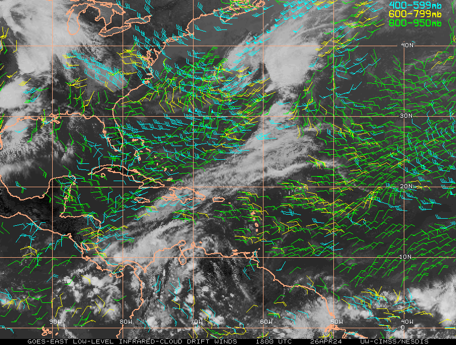
The low level vorticity at 850 mb is very weak in the vicinity of the convection. The main vorticity lobe is situated farther south, and it has been weakening. There is a high amplitude low level moisture surge in the area, but convergence is essentially non-existent. All of the convection is attributable to the well defined divergence (varying wind speeds among heights) in the area. Without substantial convergence/LL vorticity, this system will not have an opportunity for development. The projected favorable environment, represented by a well defined 250 mb anticyclone, also indicates the absence of any defined forcing for convection. The ECMWF and GFS do not develop a closed low/sfc reflection as the system passes through the Lesser Antilles. Only the unreliable NAM develops a sfc low. Thus, I don't envision any significant development with this system. Furthermore, any land interaction with Puerto Rico/Hispaniola would affect any remnant vorticity lobes.
0 likes   

tolakram
Admin
Admin
Posts: 20012
Age: 62
Joined: Sun Aug 27, 2006 8:23 pm
Location: Florence, KY (name is Mark)

Re: Central Atlantic disturbance

#4 Postby tolakram » Mon Aug 10, 2009 4:25 pm

Glad you started this thread, because I noticed this:

http://www.ssd.noaa.gov/PS/TROP/TCFP/
Image
0 likes   

User avatar
cycloneye
Admin
Admin
Posts: 145604
Age: 68
Joined: Thu Oct 10, 2002 10:54 am
Location: San Juan, Puerto Rico

Re: Central Atlantic disturbance

#5 Postby cycloneye » Mon Aug 10, 2009 4:36 pm

Ivan,its getting dark in that visible loop.An infared image is needed.
0 likes   

User avatar
Gustywind
Category 5
Category 5
Posts: 12334
Joined: Mon Sep 03, 2007 7:29 am
Location: Baie-Mahault, GUADELOUPE

#6 Postby Gustywind » Mon Aug 10, 2009 4:41 pm

Image
0 likes   

User avatar
KWT
Category 5
Category 5
Posts: 31415
Joined: Tue Aug 17, 2004 11:02 am
Location: UK!!!

#7 Postby KWT » Mon Aug 10, 2009 5:35 pm

Well the models are seeing something but really I can't see anything there to develop really to be honest, sure there is some convection but its got a massive way to go yet!

Still this seems to be the season where you take anything you can!
0 likes   

Aric Dunn
Category 5
Category 5
Posts: 21238
Age: 42
Joined: Sun Sep 19, 2004 9:58 pm
Location: Ready for the Chase.
Contact:

#8 Postby Aric Dunn » Mon Aug 10, 2009 7:33 pm

yeah keep an eye on it for sure.. I have been waiting for convection to fire with it as it approaches the islands.. all this system needs is some convergence and the surface and with the increasing moisture and upper divergence we may see some decent convection fire tonight. Given that there is a broad circulation that exists already, only a good increase in convection would give this system a shot as well.
0 likes   

User avatar
Ivanhater
Storm2k Moderator
Storm2k Moderator
Posts: 11162
Age: 38
Joined: Fri Jul 01, 2005 8:25 am
Location: Pensacola

Re: Central Atlantic disturbance

#9 Postby Ivanhater » Mon Aug 10, 2009 10:08 pm

00z NAM really likes it

Image
0 likes   

User avatar
cycloneye
Admin
Admin
Posts: 145604
Age: 68
Joined: Thu Oct 10, 2002 10:54 am
Location: San Juan, Puerto Rico

Re: Central Atlantic disturbance

#10 Postby cycloneye » Mon Aug 10, 2009 10:12 pm

:uarrow: Yeah,it has in 66 hours a L over me.
0 likes   

User avatar
tailgater
S2K Supporter
S2K Supporter
Posts: 3339
Joined: Sun Jul 11, 2004 9:13 pm
Location: St. Amant La.

Re: Central Atlantic disturbance

#11 Postby tailgater » Mon Aug 10, 2009 10:57 pm

Pretty clear where the low level curvature in this pic.
http://cimss.ssec.wisc.edu/tropic2/real ... /wg8ir.GIF
0 likes   

RL3AO
Moderator-Pro Met
Moderator-Pro Met
Posts: 16308
Joined: Thu Jun 14, 2007 10:03 pm
Location: NC

Re: Central Atlantic disturbance

#12 Postby RL3AO » Tue Aug 11, 2009 12:39 am

TROPICAL WEATHER OUTLOOK
NWS TPC/NATIONAL HURRICANE CENTER MIAMI FL
200 AM EDT TUE AUG 11 2009

FOR THE NORTH ATLANTIC...CARIBBEAN SEA AND THE GULF OF MEXICO...

A BROAD AREA OF LOW PRESSURE LOCATED A COUPLE HUNDRED MILES WEST
OF THE SOUTHERN CAPE VERDE ISLANDS IS MOVING WESTWARD AT 10 TO 15
MPH. THE ASSOCIATED SHOWER AND THUNDERSTORM ACTIVITY HAS INCREASED
SOMEWHAT AND THIS SYSTEM HAS THE POTENTIAL TO BECOME A TROPICAL
DEPRESSION DURING THE NEXT DAY OR SO. THERE IS A MEDIUM CHANCE...
30 TO 50 PERCENT...OF THIS SYSTEM BECOMING A TROPICAL CYCLONE
DURING THE NEXT 48 HOURS.

A TROPICAL WAVE LOCATED ABOUT 600 MILES EAST OF THE LESSER ANTILLES
IS PRODUCING DISORGANIZED SHOWERS AND THUNDERSTORMS. ANY
DEVELOPMENT OF THIS SYSTEM IS LIKELY TO BE SLOW AS IT MOVES
WESTWARD AT 10 TO 15 MPH. THERE IS A LOW CHANCE...LESS THAN 30
PERCENT...OF THIS SYSTEM BECOMING A TROPICAL CYCLONE DURING THE
NEXT 48 HOURS.


A SMALL AREA OF LOW PRESSURE ASSOCIATED WITH A TROPICAL WAVE IS
PRODUCING DISORGANIZED SHOWERS AND THUNDERSTORMS NEAR THE WINDWARD
ISLANDS. DEVELOPMENT OF THIS SYSTEM...IF ANY...IS EXPECTED TO BE
SLOW TO OCCUR AS IT MOVES WESTWARD AT 10 TO 15 MPH OVER THE
SOUTHEASTERN CARIBBEAN SEA DURING THE NEXT COUPLE OF DAYS. THERE
IS A LOW CHANCE...LESS THAN 30 PERCENT...OF THIS SYSTEM BECOMING A
TROPICAL CYCLONE DURING THE NEXT 48 HOURS.

ELSEWHERE...TROPICAL CYCLONE FORMATION IS NOT EXPECTED DURING THE
NEXT 48 HOURS.

$$
FORECASTER PASCH
0 likes   

User avatar
Fego
S2K Supporter
S2K Supporter
Posts: 767
Age: 65
Joined: Sun Apr 18, 2004 7:58 pm
Location: San Juan, Puerto Rico
Contact:

Re: Central Atlantic disturbance

#13 Postby Fego » Tue Aug 11, 2009 12:41 am

Image
0 likes   

floridasun78
Category 5
Category 5
Posts: 3755
Joined: Sun May 17, 2009 10:16 pm
Location: miami fl

#14 Postby floridasun78 » Tue Aug 11, 2009 1:06 am

yes it on map at 2am more circle on map
0 likes   

Aric Dunn
Category 5
Category 5
Posts: 21238
Age: 42
Joined: Sun Sep 19, 2004 9:58 pm
Location: Ready for the Chase.
Contact:

#15 Postby Aric Dunn » Tue Aug 11, 2009 3:59 am

Ok peeps watch this much more closely today.. i can see a tightening circulation and convection firing on top of it now. this has the set up to develop pretty quickly..
0 likes   

User avatar
ronjon
Category 5
Category 5
Posts: 4824
Joined: Fri Aug 19, 2005 5:17 pm
Location: Hernando Beach, FL

Re: Central Atlantic disturbance

#16 Postby ronjon » Tue Aug 11, 2009 6:01 am

00Z GFDL actually develops this system at the end of the run for 99L (now TD No. 2) in the FL straits.

http://moe.met.fsu.edu/cgi-bin/gfdltc2.cgi?time=2009081100-invest99l&field=Sea+Level+Pressure&hour=Animation
0 likes   

User avatar
cycloneye
Admin
Admin
Posts: 145604
Age: 68
Joined: Thu Oct 10, 2002 10:54 am
Location: San Juan, Puerto Rico

Re: Central Atlantic disturbance

#17 Postby cycloneye » Tue Aug 11, 2009 6:40 am

ABNT20 KNHC 111136
TWOAT
TROPICAL WEATHER OUTLOOK
NWS TPC/NATIONAL HURRICANE CENTER MIAMI FL
800 AM EDT TUE AUG 11 2009

FOR THE NORTH ATLANTIC...CARIBBEAN SEA AND THE GULF OF MEXICO...

THE NATIONAL HURRICANE CENTER HAS INITIATED ADVISORIES ON TROPICAL
DEPRESSION ONE...LOCATED ABOUT 280 MILES WEST OF THE SOUTHERNMOST
CAPE VERDE ISLANDS.


SHOWER AND THUNDERSTORM ACTIVITY ASSOCIATED WITH A TROPICAL WAVE
LOCATED ABOUT 600 MILES EAST OF THE LESSER ANTILLES REMAINS
DISORGANIZED. DEVELOPMENT OF THIS SYSTEM IS LIKELY TO BE SLOW AS
IT MOVES WESTWARD AT 10 TO 15 MPH. THERE IS A LOW CHANCE...LESS
THAN 30 PERCENT...OF THIS SYSTEM BECOMING A TROPICAL CYCLONE DURING
THE NEXT 48 HOURS.

ELSEWHERE...TROPICAL CYCLONE FORMATION IS NOT EXPECTED DURING THE
NEXT 48 HOURS.

PUBLIC ADVISORIES ON TROPICAL DEPRESSION ONE ARE ISSUED UNDER WMO
HEADER WTNT32 KNHC AND UNDER AWIPS HEADER MIATCPAT2. FORECAST/
ADVISORIES ON TROPICAL DEPRESSION ONE ARE ISSUED UNDER WMO HEADER
WTNT22 KNHC AND UNDER AWIPS HEADER MIATCMAT2.

$$
FORECASTER BERG
0 likes   

User avatar
Gustywind
Category 5
Category 5
Posts: 12334
Joined: Mon Sep 03, 2007 7:29 am
Location: Baie-Mahault, GUADELOUPE

#18 Postby Gustywind » Tue Aug 11, 2009 7:14 am

000
AXNT20 KNHC 111152
TWDAT

TROPICAL WEATHER DISCUSSION
NWS TPC/NATIONAL HURRICANE CENTER MIAMI FL
805 AM EDT TUE AUG 11 2009

TROPICAL WEATHER DISCUSSION FOR NORTH AMERICA...CENTRAL
AMERICA...GULF OF MEXICO...CARIBBEAN SEA...NORTHERN SECTIONS
OF SOUTH AMERICA...AND ATLANTIC OCEAN TO THE AFRICAN COAST
FROM THE EQUATOR TO 32N. THE FOLLOWING INFORMATION IS BASED
ON SATELLITE IMAGERY...METEOROLOGICAL ANALYSIS...WEATHER
OBSERVATIONS...AND RADAR.

BASED ON 0600 UTC SURFACE ANALYSIS AND SATELLITE IMAGERY THROUGH
WWWW UTC.

...TROPICAL WAVES...

TROPICAL WAVE IS ALONG 49W/50W S OF 18N MOVING W NEAR 10 KT. THE
AXIS OF THE WAVE IS ORIENTED WITHIN A BROAD MOISTURE MAXIMUM
OBSERVED IN TOTAL PRECIPITABLE WATER IMAGERY WITH CLUSTERS OF
SCATTERED MODERATE/ISOLATED STRONG CONVECTION ARE WITHIN 75/90
NM OF LINE FROM 18N48W TO 13N52W.

$$
WALLACE
0 likes   

User avatar
Gustywind
Category 5
Category 5
Posts: 12334
Joined: Mon Sep 03, 2007 7:29 am
Location: Baie-Mahault, GUADELOUPE

#19 Postby Gustywind » Tue Aug 11, 2009 7:15 am

Here is a sat/pic of this twave:
Image
0 likes   

User avatar
wx247
S2K Supporter
S2K Supporter
Posts: 14279
Age: 41
Joined: Wed Feb 05, 2003 10:35 pm
Location: Monett, Missouri
Contact:

#20 Postby wx247 » Tue Aug 11, 2009 8:07 am

Thunderstorm activity doesn't appear to be concentrated. I will keep one eye on this for changes, but it looks like for now there are some other areas with better potential.
0 likes   


Return to “Talkin' Tropics”

Who is online

Users browsing this forum: jhpigott, JtSmarts, weatherwindow and 79 guests