Disturbance In Eastern Caribbean.
Moderator: S2k Moderators
Forum rules

The posts in this forum are NOT official forecasts and should not be used as such. They are just the opinion of the poster and may or may not be backed by sound meteorological data. They are NOT endorsed by any professional institution or STORM2K. For official information, please refer to products from the National Hurricane Center and National Weather Service.

Re: Disturbance East Of Windward Islands.
Local met mentioned this evening that this system entering the Caribbean should be in the Southern GOM by early next week. Is this a possibility or is the met missing this big time? I know that it is early, but what is the official expected future for this system?
0 likes
-
SEASON_CANCELED

- Category 3

- Posts: 887
- Joined: Mon Jul 06, 2009 5:17 am
- Location: 8 Bit Charlie Sheen
Re: Disturbance East Of Windward Islands.
LaBreeze wrote:Local met mentioned this evening that this system entering the Caribbean should be in the Southern GOM by early next week. Is this a possibility or is the met missing this big time? I know that it is early, but what is the official expected future for this system?
Yes it is. A few of the model runs threw this scenario out there. Right now its poofing but i suspect it will be back tommorrow. Im watching this spot pretty closely. It will enter a more favorable area after wednesday
0 likes


-
SEASON_CANCELED
- Category 3
- Posts: 887
- Joined: Mon Jul 06, 2009 5:17 am
- Location: 8 Bit Charlie Sheen

Re: Disturbance East Of Windward Islands.
looked to good today I guess. Low shear, good ssts,....I am guessing it was in the mid levels and never made it to the surface. Will see if it refires tonight....
0 likes

-
srainhoutx

- S2K Supporter

- Posts: 6919
- Age: 68
- Joined: Sun Jan 14, 2007 11:34 am
- Location: Haywood County, NC
- Contact:
Re:
HURAKAN wrote:With this system you get a few hours of "" and a lot of hours of "
"
At least wxman57 has some "team activity" for the restless natives.
0 likes
-
wxman57

- Moderator-Pro Met

- Posts: 23175
- Age: 68
- Joined: Sat Jun 21, 2003 8:06 pm
- Location: Houston, TX (southwest)
Re: Disturbance East Of Windward Islands.
LaBreeze wrote:Local met mentioned this evening that this system entering the Caribbean should be in the Southern GOM by early next week. Is this a possibility or is the met missing this big time? I know that it is early, but what is the official expected future for this system?
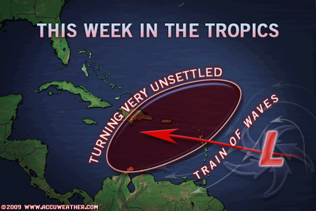
I'm not sure what the "local met" was looking at. The GFS, Canadian and ECMWF take the vorticity center straight west into Honduras in 3-4 days. The mean 700-400mb flow is straight west and even a little south of west in the western and central Caribbean. So don't look for this system to move into the Gulf. And as I mentioned earlier, it should be accelerating westward in another 24 hours, nearly doubling its forward speed in 2-3 days. That should limit (or eliminate) any surface convergence, resulting in thunderstorm dissipation.
That said, the models have taken the wave immediately behind this disturbance (no convection) more WNW toward the SE Gulf next weekend, but it probably won't amount to anything but a little more moisture flowing inland into the Gulf coast late in the weekend.
0 likes
-
wxman57
- Moderator-Pro Met
- Posts: 23175
- Age: 68
- Joined: Sat Jun 21, 2003 8:06 pm
- Location: Houston, TX (southwest)
Re: Re:
srainhoutx wrote:HURAKAN wrote:With this system you get a few hours of "
At least wxman57 has some "team activity" for the restless natives.
Yeah, a little action. This week is just a warm up for next week's real action. Going to bed. Think I got 3 hours sleep last night (cat issues, not weather related).
0 likes
-
micktooth

- S2K Supporter
- Posts: 391
- Joined: Mon Jul 11, 2005 3:47 pm
- Location: PreK:New Orleans,PostK:Colorado
Re: Re:
wxman57 wrote:srainhoutx wrote:HURAKAN wrote:With this system you get a few hours of "
At least wxman57 has some "team activity" for the restless natives.
Yeah, a little action. This week is just a warm up for next week's real action. Going to bed. Think I got 3 hours sleep last night (cat issues, not weather related).
Was it a Cat 1 or a Cat 5
0 likes
-
Gustywind

- Category 5

- Posts: 12334
- Joined: Mon Sep 03, 2007 7:29 am
- Location: Baie-Mahault, GUADELOUPE
Re: Disturbance East Of Windward Islands.
cycloneye wrote::uarrow: They always magnify things.
A meteo culture?
0 likes
-
Ed Mahmoud
Re: Disturbance East Of Windward Islands.
Ed Mahmoud wrote:Its coming right at us!!!!

I love that movie, and it just seemed so appropriate...
0 likes
-
Ed Mahmoud
Re: Re:
wxman57 wrote:srainhoutx wrote:HURAKAN wrote:With this system you get a few hours of "
At least wxman57 has some "team activity" for the restless natives.
Yeah, a little action. This week is just a warm up for next week's real action. Going to bed. Think I got 3 hours sleep last night (cat issues, not weather related).
I guess he picked a bad week to give up smoking...
0 likes
Re: Disturbance East Of Windward Islands.
Diurnal minimum. No surprise. See if it refires tomorrow.
0 likes
Re: Disturbance East Of Windward Islands.
TROPICAL WEATHER OUTLOOK
NWS TPC/NATIONAL HURRICANE CENTER MIAMI FL
200 AM EDT TUE AUG 11 2009
FOR THE NORTH ATLANTIC...CARIBBEAN SEA AND THE GULF OF MEXICO...
A BROAD AREA OF LOW PRESSURE LOCATED A COUPLE HUNDRED MILES WEST
OF THE SOUTHERN CAPE VERDE ISLANDS IS MOVING WESTWARD AT 10 TO 15
MPH. THE ASSOCIATED SHOWER AND THUNDERSTORM ACTIVITY HAS INCREASED
SOMEWHAT AND THIS SYSTEM HAS THE POTENTIAL TO BECOME A TROPICAL
DEPRESSION DURING THE NEXT DAY OR SO. THERE IS A MEDIUM CHANCE...
30 TO 50 PERCENT...OF THIS SYSTEM BECOMING A TROPICAL CYCLONE
DURING THE NEXT 48 HOURS.
A TROPICAL WAVE LOCATED ABOUT 600 MILES EAST OF THE LESSER ANTILLES
IS PRODUCING DISORGANIZED SHOWERS AND THUNDERSTORMS. ANY
DEVELOPMENT OF THIS SYSTEM IS LIKELY TO BE SLOW AS IT MOVES
WESTWARD AT 10 TO 15 MPH. THERE IS A LOW CHANCE...LESS THAN 30
PERCENT...OF THIS SYSTEM BECOMING A TROPICAL CYCLONE DURING THE
NEXT 48 HOURS.
A SMALL AREA OF LOW PRESSURE ASSOCIATED WITH A TROPICAL WAVE IS
PRODUCING DISORGANIZED SHOWERS AND THUNDERSTORMS NEAR THE WINDWARD
ISLANDS. DEVELOPMENT OF THIS SYSTEM...IF ANY...IS EXPECTED TO BE
SLOW TO OCCUR AS IT MOVES WESTWARD AT 10 TO 15 MPH OVER THE
SOUTHEASTERN CARIBBEAN SEA DURING THE NEXT COUPLE OF DAYS. THERE
IS A LOW CHANCE...LESS THAN 30 PERCENT...OF THIS SYSTEM BECOMING A
TROPICAL CYCLONE DURING THE NEXT 48 HOURS.
ELSEWHERE...TROPICAL CYCLONE FORMATION IS NOT EXPECTED DURING THE
NEXT 48 HOURS.
$$
FORECASTER PASCH
0 likes


Re: Disturbance East Of Windward Islands.
wxman57 wrote:LaBreeze wrote:Local met mentioned this evening that this system entering the Caribbean should be in the Southern GOM by early next week. Is this a possibility or is the met missing this big time? I know that it is early, but what is the official expected future for this system?
I'm not sure what the "local met" was looking at. The GFS, Canadian and ECMWF take the vorticity center straight west into Honduras in 3-4 days. The mean 700-400mb flow is straight west and even a little south of west in the western and central Caribbean. So don't look for this system to move into the Gulf. And as I mentioned earlier, it should be accelerating westward in another 24 hours, nearly doubling its forward speed in 2-3 days. That should limit (or eliminate) any surface convergence, resulting in thunderstorm dissipation.
That said, the models have taken the wave immediately behind this disturbance (no convection) more WNW toward the SE Gulf next weekend, but it probably won't amount to anything but a little more moisture flowing inland into the Gulf coast late in the weekend.
I do believe the "local met" was talking about the wave immediately behind this disturbance. Maybe I didn't make myself clear, sorry.
0 likes
-
cycloneye

- Admin

- Posts: 149508
- Age: 69
- Joined: Thu Oct 10, 2002 10:54 am
- Location: San Juan, Puerto Rico
Re: Disturbance East Of Windward Islands.
ABNT20 KNHC 111136
TWOAT
TROPICAL WEATHER OUTLOOK
NWS TPC/NATIONAL HURRICANE CENTER MIAMI FL
800 AM EDT TUE AUG 11 2009
FOR THE NORTH ATLANTIC...CARIBBEAN SEA AND THE GULF OF MEXICO...
THE NATIONAL HURRICANE CENTER HAS INITIATED ADVISORIES ON TROPICAL
DEPRESSION ONE...LOCATED ABOUT 280 MILES WEST OF THE SOUTHERNMOST
CAPE VERDE ISLANDS.
A SMALL AREA OF LOW PRESSURE ASSOCIATED WITH A TROPICAL WAVE
CONTINUES TO PRODUCE DISORGANIZED SHOWERS AND THUNDERSTORMS NEAR
THE WINDWARD ISLANDS. DEVELOPMENT...IF ANY...IS EXPECTED TO BE
SLOW TO OCCUR AS IT MOVES GENERALLY WESTWARD AT 10 TO 15 MPH OVER
THE SOUTHEASTERN CARIBBEAN SEA DURING THE NEXT COUPLE OF DAYS.
THERE IS A LOW CHANCE...LESS THAN 30 PERCENT...OF THIS SYSTEM
BECOMING A TROPICAL CYCLONE DURING THE NEXT 48 HOURS. LOCALLY
HEAVY RAIN AND GUSTY WINDS WILL CONTINUE TO AFFECT PORTIONS OF THE
WINDWARD ISLANDS THE REST OF TODAY.
0 likes
Who is online
Users browsing this forum: No registered users and 298 guests