
Latest NAM Run has wave passing over the Greater Antilles thankfully.
http://www.nco.ncep.noaa.gov/pmb/nwprod ... loop.shtml
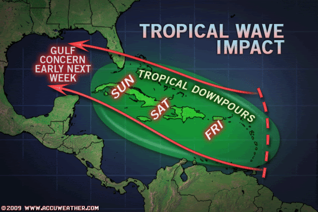
Possible Gulf Develpoment Next Weekend???
Moderator: S2k Moderators
Forum rules

The posts in this forum are NOT official forecasts and should not be used as such. They are just the opinion of the poster and may or may not be backed by sound meteorological data. They are NOT endorsed by any professional institution or STORM2K. For official information, please refer to products from the National Hurricane Center and National Weather Service.
-
srainhoutx

- S2K Supporter

- Posts: 6919
- Age: 68
- Joined: Sun Jan 14, 2007 11:34 am
- Location: Haywood County, NC
- Contact:


Re: Possible Gulf Develpoment Next Weekend???
srainhoutx wrote::uarrow: Matches well with the 00Z GFDL.
what for TD2?
nevermind....saw it.....betting the NAM closing it off in the GOM in the next few runs.... NAM is never conservative....
Last edited by ROCK on Wed Aug 12, 2009 10:49 am, edited 1 time in total.
0 likes
-
srainhoutx
- S2K Supporter
- Posts: 6919
- Age: 68
- Joined: Sun Jan 14, 2007 11:34 am
- Location: Haywood County, NC
- Contact:
Re: Possible Gulf Develpoment Next Weekend???
ROCK wrote:srainhoutx wrote::uarrow: Matches well with the 00Z GFDL.
what for TD2?
Yes. It was just about to go off the grid passing into the FL Straits (E of Caribbean wave) and showed the beginning of a closed low near the Keys, Paul. Today's 12Z's may show something totally different though. lol
http://moe.met.fsu.edu/cgi-bin/gfdltc2. ... =Animation
0 likes
-
southerngale

- Retired Staff

- Posts: 27418
- Joined: Thu Oct 10, 2002 1:27 am
- Location: Southeast Texas (Beaumont area)
Re: Possible Gulf Develpoment Next Weekend???
Stormcenter wrote:If I believed everything the "models" predicted I'd be a basket case.
Jeff Lindner is starting to remind me a lot of that Joe guy from Accuweather.
That should be a compliment to most mets, but recognizing your intent, and then your subsequent comment of claiming hype, yeah... because it is hype to tell people what is currently going on in the tropics, what the models are saying, and reminding people (in AUGUST) to "review your hurricane preparation plans and make sure your Hurricane Ike supplies are fully re-stocked."
You clearly don't know what hype is.
0 likes
Re: Possible Gulf Develpoment Next Weekend???
southerngale wrote:Stormcenter wrote:If I believed everything the "models" predicted I'd be a basket case.
Jeff Lindner is starting to remind me a lot of that Joe guy from Accuweather.
That should be a compliment to most mets, but recognizing your intent, and then your subsequent comment of claiming hype, yeah... because it is hype to tell people what is currently going on in the tropics, what the models are saying, and reminding people (in AUGUST) to "review your hurricane preparation plans and make sure your Hurricane Ike supplies are fully re-stocked."
You clearly don't know what hype is.
and boom goes the dynomite...
0 likes
-
Stormcenter
- S2K Supporter
- Posts: 6689
- Joined: Wed Sep 03, 2003 11:27 am
- Location: Houston, TX
Re: Possible Gulf Develpoment Next Weekend???
But there is nothing going on in the tropics "right now" except for a TD#2 the rest is all speculation based on model runs in reference to waves that we all know can change especially this far out. Do you remember that phantom monster storm ALL of the models predicted would form and skirt along the GOM coastline? It never happened. The only thing that happened was the price of oil skyrocketed. What about the monster Katrina like storm the EURO had hitting N.O. last season? You really don't believe some of the TV/Radio/Internet Mets don't jump on this stuff (Model runs)for ratings and hits on their web sites? Just my 2 cents
southerngale wrote:Stormcenter wrote:If I believed everything the "models" predicted I'd be a basket case.
Jeff Lindner is starting to remind me a lot of that Joe guy from Accuweather.
That should be a compliment to most mets, but recognizing your intent, and then your subsequent comment of claiming hype, yeah... because it is hype to tell people what is currently going on in the tropics, what the models are saying, and reminding people (in AUGUST) to "review your hurricane preparation plans and make sure your Hurricane Ike supplies are fully re-stocked."
You clearly don't know what hype is.
0 likes
-
gboudx

- S2K Supporter
- Posts: 4090
- Joined: Thu Sep 04, 2003 1:39 pm
- Location: Rockwall, Tx but from Harvey, La
Re: Possible Gulf Develpoment Next Weekend???
Stormcenter wrote:But there is nothing going on in the tropics "right now" except for a TD#2 the rest is all speculation based on model runs in reference to waves that we all know can change especially this far out. Do you remember that phantom monster storm ALL of the models predicted would form and skirt along the GOM coastline? It never happened. The only thing that happened was the price of oil skyrocketed. What about the monster Katrina like storm the EURO had hitting N.O. last season? You really don't believe some of the TV/Radio/Internet Mets don't jump on this stuff (Model runs)for ratings and hits on their web sites? Just my 2 cents
Jeff doesn't work for TV/Radio/Internet. He sends emails to people on his mailing list, for which there is no charge. You are comparing apples to oranges.
0 likes
-
Stormcenter
- S2K Supporter
- Posts: 6689
- Joined: Wed Sep 03, 2003 11:27 am
- Location: Houston, TX
Re: Possible Gulf Develpoment Next Weekend???
My criticism should not have been directed at Mr. Lindner so I apologize. It was to those Mets only that are already saying this (African wave) is a "threat" to South Florida or whatever when it hasn't even developed just based on model runs that we all know can be BIG TIME wrong. All it does is cause unnecessary fear and stress on people already burdened with that thanks to our poor economy and other things. When there is actually a strong storm out there then I can understand it but that's not the case right now. Again just my 2 cents.
gboudx wrote:Stormcenter wrote:But there is nothing going on in the tropics "right now" except for a TD#2 the rest is all speculation based on model runs in reference to waves that we all know can change especially this far out. Do you remember that phantom monster storm ALL of the models predicted would form and skirt along the GOM coastline? It never happened. The only thing that happened was the price of oil skyrocketed. What about the monster Katrina like storm the EURO had hitting N.O. last season? You really don't believe some of the TV/Radio/Internet Mets don't jump on this stuff (Model runs)for ratings and hits on their web sites? Just my 2 cents
Jeff doesn't work for TV/Radio/Internet. He sends emails to people on his mailing list, for which there is no charge. You are comparing apples to oranges.
0 likes
-
gboudx
- S2K Supporter
- Posts: 4090
- Joined: Thu Sep 04, 2003 1:39 pm
- Location: Rockwall, Tx but from Harvey, La
Re: Possible Gulf Develpoment Next Weekend???
Stormcenter wrote:My criticism should not have been directed at Mr. Lindner so I apologize. It was to those Mets only that are already saying this (African wave) is a "threat" to South Florida or whatever when it hasn't even developed just based on model runs that we all know can be BIG TIME wrong. All it does is cause unnecessary fear and stress on people already burdened with that thanks to our poor economy and other things. When there is actually a strong storm out there then I can understand it but that's not the case right now. Again just my 2 cents.
That's cool and understood. While I don't agree that we've threadjacked with this discussion, I guess we should just end it. L8r.
0 likes

Re: Possible Gulf Develpoment Next Weekend???
Excerpt from the Mobile NWS AFD this morning:
BY LATE SUN
INTO MON MOST OF THE LONGER RANGE GUIDANCE SUGGESTS A WEAK TO
MODERATE TROP WAVE MOVING EASTWARD OVER THE NE AND N CENTRAL GULF
GIVING WAY TO DEEPER MOISTURE FOR MUCH OF THE CWFA BY EARLY NEXT
WEEK. WITH WEAK TO MODERATE FORCING ALOFT WITH THIS FEATURE GOOD
COVERAGE OF SHOWERS AND THUNDERSTORMS MOSTLY DIURNALLY DRIVEN WILL
CONTINUE ACROSS MUCH OF THE CWFA MON THROUGH MIDWEEK.
0 likes
-
gboudx
- S2K Supporter
- Posts: 4090
- Joined: Thu Sep 04, 2003 1:39 pm
- Location: Rockwall, Tx but from Harvey, La
Re: Possible Gulf Develpoment Next Weekend???
N2Storms wrote:Excerpt from the Mobile NWS AFD this morning:
DFW mentioned it again this morning as well.
...
HOWEVER...THINGS MAY GET INTERESTING EARLY NEXT
WEEK. RIDGE BUILDS EASTWARD BY THE WEEKEND...WHICH ALLOWS A
TROPICAL WAVE CURRENTLY EAST OF THE LESSER ANTILLES TO ROTATE
AROUND THE SOUTHERN EDGE OF THE RIDGE. THERE IS ALOT OF IFS WITH
THIS WAVE FOR IT TO ACTUALLY MAKE IT INTO NORTH TEXAS BUT THE
ECMWF AND CANADIAN MODELS TRACK IT INTO THE UPPER TEXAS COAST AND
INTO NORTH TEXAS ON TUESDAY. THE ECMWF KEEPS IT AS AN OPEN WAVE
BUT THE CANADIAN CLOSES OFF A SURFACE LOW IN THE GULF OF MEXICO.
ALMOST A WEEK TO WATCH THIS AND SEE HOW IT PLAYS OUT BUT WILL
BROAD BRUSH 20 POPS ACROSS THE CWA MONDAY-TUESDAY.
0 likes
Re: Possible Gulf Develpoment Next Weekend???
12z CMC dropped developement....as does the 12z GFS to some extent....
CMC run was a bad run, showing a merging of TD2 and soon to be ANA or Bill....
CMC run was a bad run, showing a merging of TD2 and soon to be ANA or Bill....
0 likes
-
JonathanBelles
- Professional-Met

- Posts: 11430
- Age: 35
- Joined: Sat Dec 24, 2005 9:00 pm
- Location: School: Florida State University (Tallahassee, FL) Home: St. Petersburg, Florida
- Contact:
NWS Tampa Bay:
.LONG TERM (FRI NIGHT THROUGH WEDNESDAY)...TROPICAL WAVE AND
ASSOCIATED MOISTURE MOVES NEAR THE SOUTHERN TIP OF THE PENINSULA
FRIDAY NIGHT. THE GFS IS TRENDING FURTHER SOUTHWARD WITH THIS
FEATURE AND THE ECMWF IS EVEN FURTHER SOUTH THAN THE LATEST GFS
RUN...AND KEEPS MOST OF THE MOISTURE OUT OF OUR AREA ENTIRELY ON
SATURDAY. WITH THIS IN MIND...ADJUSTED POPS SLIGHTLY ON
SATURDAY...KEEPING LIKELY POPS FOR THE SOUTHERN TWO THIRDS OF THE
AREA AND SCALING BACK TO HIGH-END CHANCE UP NORTH AWAY FROM MOISTURE
AXIS. THIS WAVE MOVES INTO THE GULF AND TOWARDS THE COAST OF MS/AL
BY SUNDAY MORNING...AND WITH THIS TRACK HIGHER COVERAGE OF STORMS
WILL LIKELY PERSIST OVER OUR COASTAL WATERS THROUGH SUNDAY
AFTERNOON. DRIER AIR IN THE WAKE OF THE WAVE INLAND HOWEVER SHOULD
SUPPRESS ACTIVITY...AND HAVE KEPT POPS JUST BELOW NORMAL (40%)
SUNDAY.
0 likes
-
HURAKAN

- Professional-Met
- Posts: 46084
- Age: 39
- Joined: Thu May 20, 2004 4:34 pm
- Location: Key West, FL
- Contact:
NWS Miami:
THE GFS IS SHOWING THE TROPICAL WAVE MOVING THROUGH OVERNIGHT
FRIDAY NIGHT/SATURDAY MORNING WITH A WELL DEFINED LOW LEVEL WIND
SURGE (850 MB WINDS 30-35 KNOTS) ON ITS HEELS. THE MAIN AXIS OF
HIGHER MOISTURE VALUES IS PROGGED TO ARRIVE DURING DAY ON SATURDAY
WHICH IS WHEN WORST OF THE WEATHER MAY OCCUR. LATEST GFS RUN
ONLY EXTENDS THE HIGHER MOISTURE TO ABOUT A NAPLES/FORT LAUDERDALE
LINE, WITH DRIER AIR TO THE NORTH. THIS UNDERSCORES THE HIGH LEVEL
OF UNCERTAINTY WITH PRECIP PATTERNS ASSOCIATED WITH TROPICAL
WAVES. NEVERTHELESS, PRESENCE OF STRONG LOW LEVEL CONVERGENCE
BEHIND THE WAVE AND UPPER DIVERGENCE ASSOCIATED WITH A
SOUTHEASTERLY WIND MAX EXTENDING FROM THE CARIBBEAN ACROSS THE
FLORIDA STRAITS SHOULD PROVIDE ENOUGH SUPPORT FOR SCT TO NUMEROUS
SHOWERS AND TSTMS SPREADING WEST DURING SATURDAY. DRIER AIR THEN
FORECAST TO FOLLOW SATURDAY NIGHT INTO EARLY NEXT WEEK WITH RETURN
TO MORE TYPICAL AUGUST PATTERN AS EASTERLY FLOW BECOMES
ENTRENCHED OVER SOUTH FLORIDA FROM DEEP LAYERED HIGH EXPECTED TO
SIT OVER THE SE UNITED STATES.
0 likes
-
Nederlander
- S2K Supporter
- Posts: 1259
- Joined: Sat Jul 19, 2008 4:28 pm
- Location: Conroe, TX
Re: Possible Gulf Develpoment Next Weekend???
ill take the rain... just keep the wind and surge down and ill be happy... i could handle a tropical storm...
0 likes
Re: Possible Gulf Develpoment Next Weekend???
Looks like an ULL developing over Haiti, maybe that and land interaction will keep this wave from developing?
http://www.ssd.noaa.gov/goes/east/carb/loop-wv.html
0 likes

Who is online
Users browsing this forum: No registered users and 278 guests