caribsue wrote:Gustywind wrote:Have a good night all and looking carefully to our EAST!
Morpheaus is thereso goodbye
Gustywind
Bon soir mes ami..... stay safe through the storm
LOL oh you're speaking good french: Bonsoir mes amis
Moderator: S2k Moderators


caribsue wrote:Gustywind wrote:Have a good night all and looking carefully to our EAST!
Morpheaus is there
Gustywind
Bon soir mes ami..... stay safe through the storm
Gustywind wrote: From a correspondant of Anguilla, link on the weather site: Stormcarib.com. Looks like things continues to heating up...http://www.stormcarib.com/reports/ ... illa.shtml
TD#2 WEAKENING,INVEST90 FORMS
From: "Steve Donahue" <steve at anguilla-weather.com>
Date: Thu, 13 Aug 2009 08:14:00 -0400
Good Morning!
Continue to watch TD#2, but it seems to be dying out. Best guess as of now it will pass to our north as a tropical storm, with maybe 50 knot winds at the center – not much for us – maybe a little rain if we’re lucky! But we are in the 5 day cone for possible tropical storm strike.
The system off the coast of Africa that developed yesterday has now been identified as Invest 90, and continues to develop. All models and forecasts I’ve seen have it intensifying, and coming our way, arriving next Wednesday. Where? Way too early to tell. But here’s a quote from one of the more reliable weather services in the US as of a few hours ago:
“Invest 90L has a good potential to eventually become a major hurricane, possibly as early as Monday. The consistency in the model guidance has been remarkable, and in addition, the low latitude track Invest 90L should take will place it in higher sea surface temperatures and not be influenced as much by the dry Saharan Air Layer.
… I think it is very possible that Invest 90L will most affect the Leeward Islands as early as Tuesday and Wednesday from Guadeloupe northward through Anguilla and then westward through the Virgin Islands. With that said, residents and vacationers throughout the Leeward and Windward Islands, as well as the US and British Virgin Islands and Puerto Rico should keep extremely close tabs on the progress of Invest 90L.”
Everyone needs to watch this system over the next few days to see what it does. Get updates every 6 hours starting at 5:00 am daily at:
http://www.nhc.noaa.gov/index.shtml
Cheers,
Steve Donahue
Anguilla, AI2640, B.W.I.
US Phone – 410-505-8661
Anguilla Phone – 264-497-8177
Websites – http://www.anguilla-weather.com & http://www.anguilla-diving.com
msbee wrote:Gustywind wrote: From a correspondant of Anguilla, link on the weather site: Stormcarib.com. Looks like things continues to heating up...http://www.stormcarib.com/reports/ ... illa.shtml
TD#2 WEAKENING,INVEST90 FORMS
From: "Steve Donahue" <steve at anguilla-weather.com>
Date: Thu, 13 Aug 2009 08:14:00 -0400
Good Morning!
Continue to watch TD#2, but it seems to be dying out. Best guess as of now it will pass to our north as a tropical storm, with maybe 50 knot winds at the center – not much for us – maybe a little rain if we’re lucky! But we are in the 5 day cone for possible tropical storm strike.
The system off the coast of Africa that developed yesterday has now been identified as Invest 90, and continues to develop. All models and forecasts I’ve seen have it intensifying, and coming our way, arriving next Wednesday. Where? Way too early to tell. But here’s a quote from one of the more reliable weather services in the US as of a few hours ago:
“Invest 90L has a good potential to eventually become a major hurricane, possibly as early as Monday. The consistency in the model guidance has been remarkable, and in addition, the low latitude track Invest 90L should take will place it in higher sea surface temperatures and not be influenced as much by the dry Saharan Air Layer.
… I think it is very possible that Invest 90L will most affect the Leeward Islands as early as Tuesday and Wednesday from Guadeloupe northward through Anguilla and then westward through the Virgin Islands. With that said, residents and vacationers throughout the Leeward and Windward Islands, as well as the US and British Virgin Islands and Puerto Rico should keep extremely close tabs on the progress of Invest 90L.”
Everyone needs to watch this system over the next few days to see what it does. Get updates every 6 hours starting at 5:00 am daily at:
http://www.nhc.noaa.gov/index.shtml
Cheers,
Steve Donahue
Anguilla, AI2640, B.W.I.
US Phone – 410-505-8661
Anguilla Phone – 264-497-8177
Websites – http://www.anguilla-weather.com & http://www.anguilla-diving.com
what reliable service is he quoting? where did that info come from? I don't see NHC saying that, do I?
isn't this a little premature?
msbee wrote:his quote was already posted on a travel site for SXM and I had to correct the poster, saying only official forecasts should be posted.
People do panic easily and often over inaccurate information.


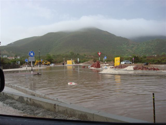
FireBird wrote:MsBee, could you tell me where in SXM that photo was taken? I used to live in Point Blanche (?) and then Cole Bay. It was a long time ago (1990-1991), and my last visit was 1994 (regrettably). I am always interested in the island as I view it as my second home. Thanks for keeping us informed, and continue to stay safe, esp. as we all look east for what next will come.
Carey
Return to “USA & Caribbean Weather”
Users browsing this forum: SnowyOwl31, TomballEd and 40 guests


