I have been surprised at the number of cold fronts actually making it through to the panhandle this time of year. It certainly a possibility for one of these stalled fronts to turn into a tropical system. It has happened before. Luckily these systems usually don't have much time to strengthen significantly before they make landfall. We will have to wait and see.
Tropicwatch
Possible Gulf Develpoment Next Weekend???
Moderator: S2k Moderators
Forum rules

The posts in this forum are NOT official forecasts and should not be used as such. They are just the opinion of the poster and may or may not be backed by sound meteorological data. They are NOT endorsed by any professional institution or STORM2K. For official information, please refer to products from the National Hurricane Center and National Weather Service.
-
tropicwatch

- Category 5

- Posts: 3426
- Age: 62
- Joined: Sat Jun 02, 2007 10:01 am
- Location: The Villages, Florida
- Contact:
-
vbhoutex

- Storm2k Executive

- Posts: 29149
- Age: 74
- Joined: Wed Oct 09, 2002 11:31 pm
- Location: Cypress, TX
- Contact:
Re: Possible Gulf Develpoment Next Weekend???
panamatropicwatch wrote:I have been surprised at the number of cold fronts actually making it through to the panhandle this time of year. It certainly a possibility for one of these stalled fronts to turn into a tropical system. It has happened before. Luckily these systems usually don't have much time to strengthen significantly before they make landfall. We will have to wait and see.
Tropicwatch
I wish it was that simple. Alicia 1983 managed Category 3 in three days. I do see the usually, but at the same time we have had billions of dollars of damage and 20+ deaths from a TS(Allison).
0 likes
-
srainhoutx

- S2K Supporter

- Posts: 6919
- Age: 68
- Joined: Sun Jan 14, 2007 11:34 am
- Location: Haywood County, NC
- Contact:
Re: Possible Gulf Develpoment Next Weekend???
Keep an eye on our wave entering the FL Straits and Keys. Radar out of Key West does have an "interesting" spin E of Marathon this morning.
http://radar.weather.gov/radar_lite.php ... R&loop=yes
Surface obs in the Straits C MAN network may be worth watching today. This area may have some potential to form into a depression as in enters the SE GOM headed westbound into the C GOM during the week. Never discount a little "home grown" activity as conditions continue to change.
http://www.srh.noaa.gov/key/marine/
0 likes
-
Janie2006

- Category 5
- Posts: 1329
- Joined: Mon Sep 18, 2006 3:28 pm
- Location: coastal Ms aka home of the hurricanes
Re: Possible Gulf Develpoment Next Weekend???
I'll give another example. Hurricane Danny (1997) went from an area of convection spawned by a mid-tropospheric trough on 13 July 1997 to a depression on 16 July, a tropical storm on 17 July, and finally a hurricane on 18 July. According to the HPC, Danny dropped 37.75 inches of rainfall over Dauphin Island. Development can occur very quickly with systems like this....assuming they have the proper environment. I'm still not biting on much development out of this particular tropical wave.
0 likes


Re: Possible Gulf Develpoment Next Weekend???
srainhoutx wrote:Keep an eye on our wave entering the FL Straits and Keys. Radar out of Key West does have an "interesting" spin E of Marathon this morning.
http://radar.weather.gov/radar_lite.php ... R&loop=yes
Surface obs in the Straits C MAN network may be worth watching today. This area may have some potential to form into a depression as in enters the SE GOM headed westbound into the C GOM during the week. Never discount a little "home grown" activity as conditions continue to change.
http://www.srh.noaa.gov/key/marine/
strainhoutx the homegrown systems are the ones that concern me the most.There is little time to get prepared, that is those who are not already prepared.
0 likes
-
SETXWXLADY
- Tropical Storm

- Posts: 216
- Joined: Wed May 20, 2009 3:26 pm
- Location: SE TX Orange County
Re: Possible Gulf Develpoment Next Weekend???
srainhoutx wrote:Keep an eye on our wave entering the FL Straits and Keys. Radar out of Key West does have an "interesting" spin E of Marathon this morning.
http://radar.weather.gov/radar_lite.php ... R&loop=yes
Surface obs in the Straits C MAN network may be worth watching today. This area may have some potential to form into a depression as in enters the SE GOM headed westbound into the C GOM during the week. Never discount a little "home grown" activity as conditions continue to change.
http://www.srh.noaa.gov/key/marine/
Looks like it may be a NW GOM system. From NWS Lake Charles
BEST CHANCE OF SHOWERS AND THUNDERSTORMS LOOK TO BE ON MONDAY AND
TUESDAY AS A TROPICAL WAVE/INVERTED TROUGH...CURRENTLY LOCATED
OVER SOUTHEAST FLORIDA AND CUBA...MOVES NORTHWEST ACROSS THE
REGION. PRECIPITABLE WATER VALUES AT OR ABOVE 2.2 INCHES WITH MEAN
RH OVER 70 PERCENT ON THOSE TWO DAYS...ESPECIALLY OVER EASTERN
ZONES...SO THERE WILL BE THE POSSIBLY OF LOCALLY HEAVY RAINFALL.
From New Orleans
HOWEVER...THE HEAVIEST AND MOST PROLIFIC PERIOD OF RAINFALL LOOKS
TO BE MONDAY INTO TUESDAY. THE TROPICAL WAVE WILL BEGIN TO PULL TO
THE WEST OF THE REGION...ALLOWING FOR THE STRONGEST LIFT AND DEEP
MOISTURE TO SWEEP INTO THE AREA. THIS MOISTURE WILL BE FED BY DEEP
SOUTHERLY FLOW OFF THE GULF OF MEXICO.
Lets hope it stays just some friendly rain.
0 likes
-
srainhoutx
- S2K Supporter
- Posts: 6919
- Age: 68
- Joined: Sun Jan 14, 2007 11:34 am
- Location: Haywood County, NC
- Contact:
Re: Possible Gulf Develpoment Next Weekend???
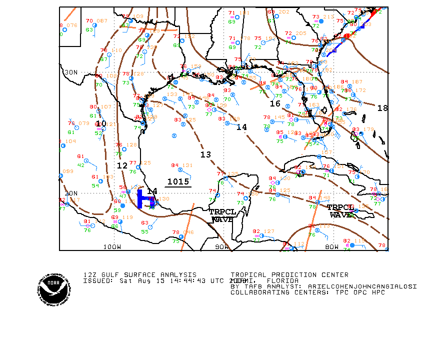
Key West update is worth the read this morning...
AREA FORECAST DISCUSSION FOR THE FLORIDA KEYS
NATIONAL WEATHER SERVICE KEY WEST FL
948 AM EDT SAT AUG 15 2009
.DISCUSSION...
.CURRENTLY...
THE NORTHERN PORTION OF A TROPICAL WAVE EXTENDING FROM THE FLORIDA
STRAITS INTO THE CARIBBEAN IS CURRENTLY MOVING WESTWARD THROUGH THE
FLORIDA STRAITS AND IS BEGINNING TO IMPACT THE MIDDLE AND UPPER
KEYS...AND WILL IMPACT THE LOWER KEYS WITHING THE NEXT FEW HOURS. A
CONVECTIVE MASS IN THE STRAITS EAST OF THE KEYS IS EVIDENT ON KBYX
RADAR...WITH A BROAD MID LEVEL CIRCULATION DETECTABLE FROM AROUND
10KFT THROUGH 25KFT. THE APPROXIMATE MAXIMUM OF THE CIRCULATION IS
AROUND 700MB...AND THERE IS ALSO A WEAK CIRCULATION DETECTED FROM
AROUND 5KFT TO THE SURFACE. SURFACE WINDS AT ISLAND STATIONS ALONG
THE KEYS HAVE BEEN MORE OF LESS SOUTHEAST FROM 5 TO 10 KNOTS OVER THE
PAST FEW HOURS...WITH CMAN STATIONS ALONG THE REEF A COUPLE OF KNOTS
BELOW 10 KNOTS WITH GUSTS NEAR 15 KNOTS. MOLASSES REEF...WHICH IS
NEAREST THE CONVECTION...HAS REGISTERED THE HIGHEST WINDS THUS FAR
WITH SUSTAINED WINDS OF 16 KNOTS AND GUSTS OF 18 KNOTS.
.SHORT TERM...
THE WEATHER IN THE KEYS AND COASTAL WATERS THROUGH EARLY EVENING WILL
BE DOMINATED BY THE PASSAGE OF THE TROPICAL WAVE. GIVEN THE RADAR
PRESENTATION...IT APPEARS THAT THE LOWER KEYS WILL MOST LIKELY BEAR
THE BRUNT OF THE CONVECTION ASSOCIATED WITH THE WAVE. IT IS MOVING
TOWARDS THE WEST AT AROUND 10 KNOTS...AND USING STRAIT EXTRAPOLATION
THAT PUTS THE WAVE IN THE LOWER KEYS AROUND 18Z. THE MORNING ZONE
FORECASTS HAVE LIKELY POPS THROUGH THE DAY AND CHANCE POPS IN THE
EVENING. WITH THE WAVE ON OUR DOORSTOP THERE IS NO REASON TO UPDATE
FORECAST AT THIS POINT.
.MARINE...
FOR THE FLORIDA STRAITS A SMALL CRAFT EXERCISE CAUTION IS IN EFFECT
FOR SOUTHEAST WINDS OF BETWEEN 15 AND 20 KNOTS. WITH PASSAGE OF THE
TROPICAL WAVE THROUGH THE AREA...NUMEROUS SHOWERS AND THUNDERSTORMS
WILL CONTINUE IN ALL FLORIDA KEYS COASTAL WATERS THOUGH THE DAY. WIND
GUSTS APPROACHING 30 KNOTS CAN BE EXPECTED IN THE VICINITY OF
THUNDERSTORMS. A SHIP REPORT AT 900AM 7 NM SOUTH OF SOMBRERO KEY
LIGHT FOUND SEAS OF 3 TO 4 FEET WITH A 6 SECOND PERIOD AND WINDS OF
9 KNOTS. HOWEVER...CONDITIONS CAN AND WILL CHANGE UNPREDICTABLY AND
RAPIDLY IN THE AREAS OF SHOWERS AND THUNDERSTORMS. PROBABLY A GOOD
DAY TO STAY IN PORT AS TOMORROW WILL BE A MUCH BETTER DAY FOR
BOATING.
0 likes
-
HouTXmetro

- Category 5
- Posts: 3949
- Joined: Sun Jun 13, 2004 6:00 pm
- Location: District of Columbia, USA
Re: Possible Gulf Develpoment Next Weekend???
I surely see a spin in the straights...Watching closely
0 likes
Re: Possible Gulf Develpoment Next Weekend???
The circulation is clearly visible on sat. I have been looking at this since yesterday.I would think that the potential once it hits the GOM is there esp. with all the moisture present in the EGOM yesterday.
http://www.ssd.noaa.gov/goes/east/gmex/loop-vis.html
http://www.ssd.noaa.gov/goes/east/gmex/loop-vis.html
0 likes
-
HouTXmetro
- Category 5
- Posts: 3949
- Joined: Sun Jun 13, 2004 6:00 pm
- Location: District of Columbia, USA
Re: Possible Gulf Develpoment Next Weekend???
Javlin wrote:The circulation is clearly visible on sat. I have been looking at this since yesterday.I would think that the potential once it hits the GOM is there esp. with all the moisture present in the EGOM yesterday.
http://www.ssd.noaa.gov/goes/east/gmex/loop-vis.html
Not to mention the GOM is boiling.
0 likes
-
SETXWXLADY
- Tropical Storm
- Posts: 216
- Joined: Wed May 20, 2009 3:26 pm
- Location: SE TX Orange County
Re: Possible Gulf Develpoment Next Weekend???
Marine Weather Discussion
--------------------------------------------------------------------------------
000
AGXX40 KNHC 150656
MIMATS
MARINE WEATHER DISCUSSION
NWS TPC/NATIONAL HURRICANE CENTER MIAMI FL
300 AM EDT SAT AUG 15 2009
MARINE WEATHER DISCUSSION FOR THE GULF OF MEXICO...CARIBBEAN SEA
AND SOUTHWEST NORTH ATLC S OF 31N W OF 55W.
WINDS ARE GENERALLY LIGHT ACROSS THE GULF OF MEXICO. HOWEVER
WINDS WILL START TO INCREASE OVER THE EASTERN GULF AS TROUGH
WHICH WAS THE NORTHERN END OF A TROPICAL WAVE MOVES INTO THE
AREA. THE TROUGH WILL MOVE ACROSS THE EASTERN AND MIDDLE GULF
TODAY AND SUN THEN INTO THE NW GULF MON AND INLAND TUE. THE
STRONGEST WINDS WILL BE OVER THE SE GULF THEN SPREAD W INTO THE
SW GULF BY MID WEEK.
Found this also. The thing that would worry me more is this system being an Humberto with more time. But so far so good. But nobody expected Humberto either. I'm still going to watch it as well.
0 likes
Re: Possible Gulf Develpoment Next Weekend???
Went and looked at some bouys and nothing on the pressure to be alarmed about but there sure is some rotation in there?
0 likes
Re: Possible Gulf Develpoment Next Weekend???
The area near or just east of Key West seems to be really spinning tightly on radar:
http://radar.weather.gov/radar.php?rid= ... R&loop=yes
And the high cloud tops are starting to "pop" near this uber-center:

http://radar.weather.gov/radar.php?rid= ... R&loop=yes
And the high cloud tops are starting to "pop" near this uber-center:
0 likes
-
srainhoutx
- S2K Supporter
- Posts: 6919
- Age: 68
- Joined: Sun Jan 14, 2007 11:34 am
- Location: Haywood County, NC
- Contact:
Re: Possible Gulf Develpoment Next Weekend???
Thats what gets me Rocky it looks the part but then again a pressure drop is needed to quantify it.
0 likes

Re: Possible Gulf Develpoment Next Weekend???
http://radar.weather.gov/radar.php?rid= ... 1&loop=yes
Check the velocity: West wind surge is showing up...can't see surface though...
Check the velocity: West wind surge is showing up...can't see surface though...
0 likes

Re: Possible Gulf Develpoment Next Weekend???
Javlin wrote:The circulation is clearly visible on sat. I have been looking at this since yesterday.I would think that the potential once it hits the GOM is there esp. with all the moisture present in the EGOM yesterday.
http://www.ssd.noaa.gov/goes/east/gmex/loop-vis.html
Is that another system trying to develop just SE of the TX/LA border in the middle of the GOM?
0 likes
Re: Possible Gulf Develpoment Next Weekend???
Well at any rate if it keeps together we along the NGOM will get some good rain and a little wind come Monday or Tuesday.
0 likes
Re: Possible Gulf Develpoment Next Weekend???
I do not really see any rotation there as with the other one what we must be seeing is something in the mid levels I would guess since there is no pressure drop.If that makes since?someone else might could answer that.
0 likes
Who is online
Users browsing this forum: WaveBreaking and 238 guests