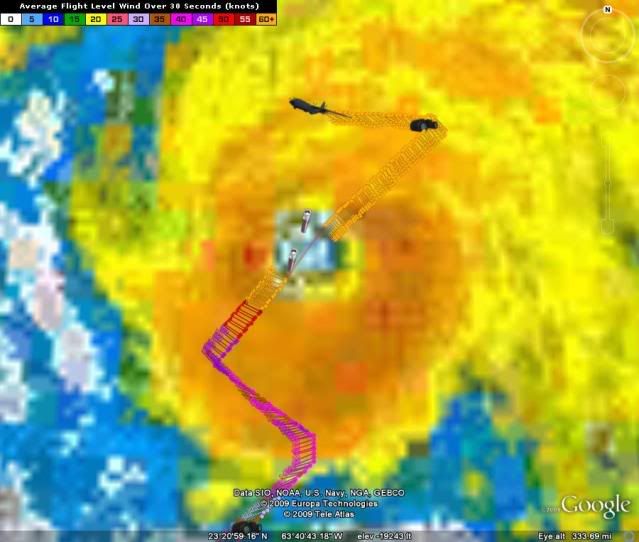
ATL: TROPICAL STORM BILL (03L)

Moderator: S2k Moderators

Message
Author
User avatar
x-y-no
Category 5
Category 5
Posts: 8359
Age: 65
Joined: Wed Aug 11, 2004 12:14 pm
Location: Fort Lauderdale, FL

Re: ATL : BILL (03L) Recon Thread

#3201 Postby x-y-no » Thu Aug 20, 2009 12:06 pm

hurricanefloyd5 wrote:dose anyone have a decoder for this info from recon??????


There's one here:

http://www.hhrecon.com/recon/

but really the HDOBs are very simple:

1) Time
2) Latitude
3) Longitude
4) Static pressure in aeroplane
5) Geopotential height
6) 30 second surface pressure mean extrapolation
7) 30 second mean air temperature
8) 30 second mean dew point
9) 30 second mean wind direction
10) 30 second mean wind
11) Ten second gust
12) Peak ten second Stepped Frequency Microwave Radiometer [SFMR] surface wind
13) SFMR precipitation rate (mm/hr)
14) Suspect data codes

Note that 9 & 10 are combined in one column
0 likes   

Derek Ortt

#3202 Postby Derek Ortt » Thu Aug 20, 2009 12:06 pm

this may turn WNW later today for about 12 hours. The UL to its NW appears to be cutting off
0 likes   

User avatar
KWT
Category 5
Category 5
Posts: 31415
Joined: Tue Aug 17, 2004 11:02 am
Location: UK!!!

#3203 Postby KWT » Thu Aug 20, 2009 12:09 pm

That could be very important if that happens Derek as it doesn't need much more westward motion to be a real threat to the NE. Will watch that closely!
0 likes   

User avatar
hurricanefloyd5
Category 5
Category 5
Posts: 1659
Age: 44
Joined: Sun May 02, 2004 10:53 am
Location: Spartanburg
Contact:

Re: ATL : BILL (03L) Recon Thread

#3204 Postby hurricanefloyd5 » Thu Aug 20, 2009 12:09 pm

x-y-no wrote:
hurricanefloyd5 wrote:dose anyone have a decoder for this info from recon??????


There's one here:

http://www.hhrecon.com/recon/

but really the HDOBs are very simple:

1) Time
2) Latitude
3) Longitude
4) Static pressure in aeroplane
5) Geopotential height
6) 30 second surface pressure mean extrapolation
7) 30 second mean air temperature
8) 30 second mean dew point
9) 30 second mean wind direction
10) 30 second mean wind
11) Ten second gust
12) Peak ten second Stepped Frequency Microwave Radiometer [SFMR] surface wind
13) SFMR precipitation rate (mm/hr)
14) Suspect data codes

Note that 9 & 10 are combined in one column


thank you very much
0 likes   

tolakram
Admin
Admin
Posts: 20010
Age: 62
Joined: Sun Aug 27, 2006 8:23 pm
Location: Florence, KY (name is Mark)

Re: ATL: HURRICANE BILL (03L)

#3205 Postby tolakram » Thu Aug 20, 2009 12:16 pm

wxman57 wrote:Note of interest. Super rapid-scan high-res visible imagery will begin in 20 minutes at the following link:

http://rammb.cira.colostate.edu/project ... isloop.asp

I believe that images will be taken at 1 minute intervals between 17Z and 2230Z today. Current images in the loop are spaced 30 minutes apart.


Stunning. Looks like 2 minutes apart, though it varies. Probably as fast as the feed can send it.

Nevertheless, stunning. Someone needs to take a video of the loop or somehow capture it. :)
0 likes   

User avatar
KWT
Category 5
Category 5
Posts: 31415
Joined: Tue Aug 17, 2004 11:02 am
Location: UK!!!

#3206 Postby KWT » Thu Aug 20, 2009 12:18 pm

Yep just seen that loop, most amazing I agree, hopefully they do this more often with these powerful hurricanes!
0 likes   

User avatar
Cookie
S2K Supporter
S2K Supporter
Posts: 477
Age: 37
Joined: Sun Dec 14, 2008 11:13 am
Location: Isle Of lewis scotland

Re:

#3207 Postby Cookie » Thu Aug 20, 2009 12:18 pm

KWT wrote:Yeah it looks like that is the feature Cookie, looks quite powerful!


yup, not bad for late summer but not quite mid winter standards
0 likes   

User avatar
HURAKAN
Professional-Met
Professional-Met
Posts: 46086
Age: 38
Joined: Thu May 20, 2004 4:34 pm
Location: Key West, FL
Contact:

#3208 Postby HURAKAN » Thu Aug 20, 2009 12:28 pm

000
URNT15 KNHC 201654
AF304 0403A BILL HDOB 16 20090820
164430 2412N 06108W 6966 03129 0062 +066 +012 131084 085 062 015 00
164500 2412N 06110W 6966 03129 0063 +065 +012 130085 085 063 015 00
164530 2412N 06113W 6969 03122 0055 +069 +013 128085 085 063 014 00
164600 2412N 06115W 6966 03123 0060 +063 +014 127088 090 067 014 00
164630 2412N 06118W 6966 03120 0053 +066 +014 125088 089 068 014 00
164700 2413N 06120W 6968 03115 0051 +066 +015 123087 088 067 015 00
164730 2413N 06123W 6966 03117 0053 +062 +015 123088 089 069 016 00
164800 2413N 06126W 6966 03114 0042 +069 +015 123088 089 069 016 00
164830 2413N 06128W 6969 03108 0044 +067 +015 127084 088 068 015 00
164900 2413N 06131W 6964 03113 0039 +066 +015 130084 084 064 017 00
164930 2413N 06133W 6967 03109 0028 +075 +015 129084 086 064 017 00
165000 2413N 06136W 6966 03107 0023 +077 +015 126086 088 066 016 00
165030 2414N 06138W 6964 03107 0024 +074 +016 124088 088 066 015 00
165100 2414N 06141W 6971 03098 0033 +066 +016 123087 088 066 016 00
165130 2414N 06144W 6965 03102 0029 +068 +016 123085 086 067 016 00
165200 2414N 06146W 6967 03101 0016 +078 +016 124081 084 070 013 00
165230 2414N 06149W 6967 03099 0006 +086 +016 124080 081 070 013 00
165300 2414N 06151W 6968 03094 9999 +088 +017 122082 082 072 011 00
165330 2414N 06154W 6968 03093 9997 +089 +018 123083 084 072 011 00
165400 2415N 06156W 6965 03097 0006 +079 +020 122084 084 072 012 00
$$
;

000
URNT15 KNHC 201704
AF304 0403A BILL HDOB 17 20090820
165430 2415N 06159W 6967 03090 0013 +071 +021 120085 085 073 016 00
165500 2415N 06201W 6969 03087 0007 +074 +020 120083 084 075 015 00
165530 2415N 06204W 6963 03090 0008 +072 +019 117088 090 075 016 00
165600 2415N 06207W 6969 03083 0010 +070 +019 115088 092 074 018 00
165630 2415N 06209W 6960 03094 0010 +071 +019 113085 086 074 015 00
165700 2415N 06212W 6970 03084 0009 +071 +019 111085 086 074 013 00
165730 2415N 06215W 6963 03094 0010 +070 +020 107087 087 074 014 00
165800 2416N 06217W 6973 03082 0011 +072 +021 105082 084 075 013 00
165830 2416N 06220W 6969 03086 0002 +079 +022 106082 084 075 012 00
165900 2416N 06223W 6966 03091 9994 +086 +023 102087 089 075 011 00
165930 2416N 06225W 6970 03086 0014 +069 +025 097086 089 074 012 00
170000 2416N 06228W 6969 03087 0021 +065 +026 092079 080 071 017 00
170030 2416N 06231W 6964 03094 0023 +062 +026 091081 082 074 017 00
170100 2416N 06233W 6969 03088 0022 +064 +027 089083 084 074 018 00
170130 2416N 06236W 6964 03096 0021 +064 +027 089086 086 073 018 00
170200 2417N 06239W 6970 03089 0024 +064 +027 087087 089 073 016 00
170230 2417N 06242W 6970 03089 0031 +058 +028 082093 095 077 018 00
170300 2417N 06244W 6969 03093 0030 +060 +028 084089 092 074 014 00
170330 2417N 06247W 6965 03102 0034 +059 +028 085088 090 074 010 00
170400 2417N 06250W 6975 03089 0028 +066 +029 084089 092 075 006 00
$$
;
0 likes   

User avatar
HURAKAN
Professional-Met
Professional-Met
Posts: 46086
Age: 38
Joined: Thu May 20, 2004 4:34 pm
Location: Key West, FL
Contact:

#3209 Postby HURAKAN » Thu Aug 20, 2009 12:28 pm

000
URNT15 KNHC 201714
AF304 0403A BILL HDOB 18 20090820
170430 2417N 06253W 6965 03106 0038 +060 +029 079089 092 074 006 00
170500 2417N 06255W 6963 03109 0043 +058 +029 078088 089 075 008 00
170530 2418N 06258W 6970 03106 0042 +063 +029 074086 089 075 008 00
170600 2418N 06301W 6964 03113 0053 +057 +029 068084 085 076 009 00
170630 2418N 06303W 6964 03116 0059 +055 +029 068082 083 077 009 03
170700 2418N 06306W 6967 03115 0058 +057 +029 067080 080 074 009 00
170730 2418N 06308W 6968 03118 0055 +063 +028 066074 078 073 009 00
170800 2418N 06311W 6967 03117 0051 +065 +028 066074 076 074 009 03
170830 2418N 06313W 6971 03115 0060 +059 +028 065078 079 073 010 03
170900 2418N 06316W 6967 03125 0056 +066 +028 064074 075 999 999 03
170930 2418N 06318W 6967 03125 0048 +074 +028 063069 072 071 007 03
171000 2419N 06321W 6967 03126 0034 +085 +029 064066 067 071 009 03
171030 2419N 06323W 6969 03130 0034 +087 +032 063065 067 073 009 03
171100 2419N 06326W 6969 03127 0032 +089 +034 060066 067 999 999 03
171130 2419N 06328W 6967 03133 0034 +091 +037 059065 066 999 999 03
171200 2419N 06331W 6967 03133 0042 +085 +039 057065 067 999 999 03
171230 2419N 06333W 6965 03136 0047 +082 +040 059064 064 999 999 03
171300 2419N 06335W 6966 03142 0053 +080 +040 060062 064 999 999 03
171330 2419N 06338W 6966 03141 0048 +085 +038 062060 060 999 999 03
171400 2419N 06340W 6967 03140 0045 +089 +036 060059 059 999 999 03
$$
;

000
URNT15 KNHC 201724
AF304 0403A BILL HDOB 19 20090820
171430 2419N 06343W 6964 03144 0049 +088 +035 059058 059 999 999 03
171500 2420N 06345W 6969 03141 0048 +090 +034 055053 054 999 999 03
171530 2420N 06347W 6969 03143 0054 +086 +033 055054 054 999 999 03
171600 2420N 06349W 6967 03144 0061 +082 +032 054055 056 999 999 03
171630 2420N 06352W 6970 03143 0065 +080 +031 051058 059 999 999 03
171700 2420N 06354W 6966 03149 0079 +071 +030 051058 058 999 999 03
171730 2420N 06356W 6966 03153 0079 +072 +029 052055 055 999 999 03
171800 2420N 06359W 6967 03151 0077 +075 +027 052053 053 999 999 03
171830 2420N 06401W 6969 03155 0080 +074 +026 050052 054 999 999 03
171900 2420N 06403W 6967 03164 0094 +070 +026 051050 052 999 999 03
171930 2419N 06405W 6969 03166 0104 +068 +026 045047 049 999 999 03
172000 2417N 06404W 6965 03160 0093 +070 +027 047045 046 999 999 03
172030 2416N 06402W 6967 03151 0082 +071 +027 048046 048 999 999 03
172100 2415N 06401W 6970 03146 0090 +062 +026 047048 048 999 999 03
172130 2415N 06401W 6970 03146 0089 +062 +024 045050 050 999 999 03
172200 2413N 06358W 6967 03144 0074 +071 +021 044051 051 999 999 03
172230 2412N 06357W 6967 03143 0067 +075 +020 045051 052 999 999 03
172300 2411N 06355W 6971 03135 0056 +082 +021 049050 050 999 999 03
172330 2410N 06354W 6967 03140 0058 +078 +023 051052 053 999 999 03
172400 2409N 06353W 6967 03136 0047 +086 +024 051051 053 999 999 03
$$
;
0 likes   

User avatar
deltadog03
Professional-Met
Professional-Met
Posts: 3580
Joined: Tue Jul 05, 2005 6:16 pm
Location: Macon, GA

Re:

#3210 Postby deltadog03 » Thu Aug 20, 2009 12:29 pm

Derek Ortt wrote:this may turn WNW later today for about 12 hours. The UL to its NW appears to be cutting off


I agree Derek. That ULL is going to be very important **IMO** to where it gets to in the long run. This could make it fairly close to the NE in the long run.
0 likes   

User avatar
HURAKAN
Professional-Met
Professional-Met
Posts: 46086
Age: 38
Joined: Thu May 20, 2004 4:34 pm
Location: Key West, FL
Contact:

#3211 Postby HURAKAN » Thu Aug 20, 2009 12:30 pm

Image
0 likes   

User avatar
HURAKAN
Professional-Met
Professional-Met
Posts: 46086
Age: 38
Joined: Thu May 20, 2004 4:34 pm
Location: Key West, FL
Contact:

Re: ATL : BILL (03L) Recon Thread

#3212 Postby HURAKAN » Thu Aug 20, 2009 12:33 pm

196
URNT12 KNHC 201628
VORTEX DATA MESSAGE AL032009
A. 20/16:06:50Z
B. 22 deg 52 min N
062 deg 12 min W
C. 700 mb 2672 m
D. 72 kt
E. 206 deg 14 nm
F. 290 deg 82 kt
G. 204 deg 12 nm
H. 951 mb
I. 10 C / 3045 m
J. 17 C / 3042 m
K. 4 C / NA
L. CLOSED WALL
M. C30
N. 1234 / 7
O. 0.02 / 1.5 nm
P. AF304 0403A BILL OB 03
MAX FL WIND 134 KT NE QUAD 16:14:30Z
MAX OUTBOUND FL WIND 134 KT NE QUAD 16:14:30Z
MAX FL TEMP 17 C 197 / 6 NM FROM FL CNTR
;

0 likes   

User avatar
storms NC
Tropical Storm
Tropical Storm
Posts: 247
Age: 69
Joined: Tue Sep 14, 2004 2:41 pm
Location: Coast of NC & southwest coast of Fla

Re: Re:

#3213 Postby storms NC » Thu Aug 20, 2009 12:34 pm

wxman57 wrote:You're not getting nervous, are you? I just calculated 3 and 12 hr movement using GARP and got a steady 305 deg heading at 17 kts for 12 hours. Same thing as if I used a 3 hr movement. I don't see any evidence of a 290-295 deg movement for any period of time. There are a few satellite images where the eye is partially covered, which could make it look like the direction changed.

storms NC wrote:Bill sure does like those jogs to the west alot. I know that NHC goes by 12 hours. But this morning he has been going about 290-295 This may be do to his little weakening. LOL from a 4 down to a 3. But that could be alot to someone that would be looking at him come their way. But he is not at this time frame.
How much more west will Bill go?It seem every up date it is a little more to the west. They keep going they will run out of water here.LOL. Now does the trough stay strong or does it weaken as time goes by. Will he catch the train up to the North? I think NHC has done a good job. It is hard to pin down where this storms will go. It is all about timing. It has been 10 years since we here around Wilm that we had a hurricane. I hope it will be many more. Floyd was the last. Yes we had a few TD or TS but that is it.
Any hows this has been a good Storm to watch and learn on. Who knows maybe he has some tricks up his sleeve. He has done good so far. All the Bill's I know are sneaky and bad.LOL


Sorry I didn't get back sooner.

Not in the less bit. I can see where it is going. I was just thowing out a few things. The What If's you might want to say. But Bill will be a few hundered miles from our coast. I bet it would be some good fishing today and the next few days.

But I do need one for around Sept 17 18th. My daughter got married a few days after floyd. Well none of my family went or I. No way to get out. Water was all around us. Took my X 5 hours to come get the kids. He was only a hour away in Raleigh.
So that way it will be the same as 10 years ago. I pick on her about this.
0 likes   

User avatar
wxman57
Moderator-Pro Met
Moderator-Pro Met
Posts: 22979
Age: 67
Joined: Sat Jun 21, 2003 8:06 pm
Location: Houston, TX (southwest)

Re: ATL: HURRICANE BILL (03L)

#3214 Postby wxman57 » Thu Aug 20, 2009 12:35 pm

Ptarmigan wrote:
wxman57 wrote:It's a function of the pressure gradient as it relates to the wind field size. Bill is smaller than Ike, so the same central pressure will generate higher winds than Ike's more spread out wind field. That's why central pressure alone isn't a good indicator of wind speeds. Wind field size isn't accounted for.


In terms of radius of outermost closed isobar?


The radius of maximum winds is larger today. The core is bigger, so the pressure gradient is reduced.
0 likes   

User avatar
HURAKAN
Professional-Met
Professional-Met
Posts: 46086
Age: 38
Joined: Thu May 20, 2004 4:34 pm
Location: Key West, FL
Contact:

#3215 Postby HURAKAN » Thu Aug 20, 2009 12:36 pm

URNT12 KNHC 201628
VORTEX DATA MESSAGE AL032009
A. 20/16:06:50Z
B. 22 deg 52 min N
062 deg 12 min W
C. 700 mb 2672 m
D. 72 kt
E. 206 deg 14 nm
F. 290 deg 82 kt
G. 204 deg 12 nm
H. 951 mb
I. 10 C / 3045 m
J. 17 C / 3042 m
K. 4 C / NA
L. CLOSED WALL
M. C30
N. 1234 / 7
O. 0.02 / 1.5 nm
P. AF304 0403A BILL OB 03
MAX FL WIND 134 KT NE QUAD 16:14:30Z
MAX OUTBOUND FL WIND 134 KT NE QUAD 16:14:30Z
MAX FL TEMP 17 C 197 / 6 NM FROM FL CNTR


Most important, closed wall
0 likes   

User avatar
ronjon
Category 5
Category 5
Posts: 4822
Joined: Fri Aug 19, 2005 5:17 pm
Location: Hernando Beach, FL

Re: ATL: HURRICANE BILL (Models)

#3216 Postby ronjon » Thu Aug 20, 2009 12:37 pm

0 likes   

User avatar
HURAKAN
Professional-Met
Professional-Met
Posts: 46086
Age: 38
Joined: Thu May 20, 2004 4:34 pm
Location: Key West, FL
Contact:

#3217 Postby HURAKAN » Thu Aug 20, 2009 12:41 pm

000
URNT15 KNHC 201735
AF304 0403A BILL HDOB 20 20090820
172430 2408N 06351W 6965 03135 0044 +085 +025 049052 053 999 999 03
172500 2407N 06350W 6971 03129 0044 +083 +026 049052 053 999 999 03
172530 2406N 06348W 6971 03124 0037 +086 +025 047053 054 999 999 03
172600 2404N 06347W 6963 03133 0039 +085 +025 046054 058 999 999 03
172630 2403N 06346W 6975 03115 0037 +083 +025 049058 059 999 999 03
172700 2402N 06344W 6968 03121 0036 +082 +025 051061 063 999 999 03
172730 2401N 06343W 6966 03121 0033 +080 +024 053063 063 999 999 03
172800 2400N 06342W 6967 03116 0033 +077 +023 052062 063 999 999 03
172830 2359N 06340W 6967 03112 0039 +070 +021 048063 064 999 999 03
172900 2358N 06339W 6967 03114 0032 +074 +020 047063 063 999 999 03
172930 2357N 06338W 6967 03111 0035 +071 +019 048065 067 999 999 03
173000 2356N 06336W 6967 03106 0036 +066 +019 046066 066 999 999 03
173030 2355N 06335W 6965 03104 0034 +066 +019 047068 069 075 010 03
173100 2354N 06334W 6969 03096 0025 +068 +019 047071 072 077 010 03
173130 2353N 06332W 6964 03092 0025 +063 +020 047068 071 078 013 03
173200 2352N 06331W 6970 03083 0022 +061 +020 049067 068 079 013 03
173230 2351N 06330W 6967 03082 0012 +064 +022 051069 070 999 999 03
173300 2349N 06328W 6964 03080 0000 +069 +023 051069 069 999 999 03
173330 2348N 06327W 6969 03070 9998 +068 +023 054071 072 999 999 03
173400 2347N 06326W 6967 03069 9980 +078 +024 057065 068 999 999 03
$$
;
0 likes   

User avatar
deltadog03
Professional-Met
Professional-Met
Posts: 3580
Joined: Tue Jul 05, 2005 6:16 pm
Location: Macon, GA

#3218 Postby deltadog03 » Thu Aug 20, 2009 12:43 pm

Image
0 likes   

User avatar
KWT
Category 5
Category 5
Posts: 31415
Joined: Tue Aug 17, 2004 11:02 am
Location: UK!!!

#3219 Postby KWT » Thu Aug 20, 2009 12:49 pm

Yep closed eyewall probably explains why the flight level winds are coming in a little bit higher recently. Also bigger core and bigger region of winds are not great for the NE, could need tropical storm watches anyway.
0 likes   

User avatar
cycloneye
Admin
Admin
Posts: 145367
Age: 68
Joined: Thu Oct 10, 2002 10:54 am
Location: San Juan, Puerto Rico

Re: ATL: HURRICANE BILL (Advisories)

#3220 Postby cycloneye » Thu Aug 20, 2009 12:53 pm

000
WTNT33 KNHC 201739
TCPAT3
BULLETIN
HURRICANE BILL INTERMEDIATE ADVISORY NUMBER 21A
NWS TPC/NATIONAL HURRICANE CENTER MIAMI FL AL032009
200 PM AST THU AUG 20 2009

...LARGE HURRICANE BILL RACING NORTHWESTWARD...SPREADING HIGH SWELLS
OVER THE WESTERN ATLANTIC...

A HURRICANE WATCH IS IN EFFECT FOR BERMUDA. A HURRICANE WATCH MEANS
THAT HURRICANE CONDITIONS ARE POSSIBLE WITHIN THE WATCH AREA...
GENERALLY WITHIN 36 HOURS.

FOR STORM INFORMATION SPECIFIC TO YOUR AREA OUTSIDE OF THE UNITED
STATES...PLEASE MONITOR PRODUCTS ISSUED BY YOUR NATIONAL
METEOROLOGICAL SERVICE.

AT 200 PM AST...1800 UTC...THE EYE OF HURRICANE BILL WAS LOCATED
NEAR LATITUDE 23.2 NORTH...LONGITUDE 62.6 WEST OR ABOUT 645
MILES...1035 KM SOUTH OF BERMUDA.

BILL IS MOVING TOWARD THE NORTHWEST NEAR 18 MPH...30 KM/HR...AND
THIS GENERAL MOTION IS EXPECTED TO CONTINUE TROUGH FRIDAY. ON THIS
FORECAST TRACK...THE CORE OF HURRICANE BILL IS EXPECTED TO PASS
OVER THE OPEN WATERS BETWEEN BERMUDA AND THE EAST COAST OF THE
UNITED STATES EARLY SATURDAY.

MAXIMUM SUSTAINED WINDS REMAIN NEAR 120 MPH...195 KM/HR...WITH
HIGHER GUSTS. BILL IS A CATEGORY THREE HURRICANE ON THE
SAFFIR-SIMPSON SCALE. SOME STRENGTHENING IS FORECAST DURING
THE NEXT 24 HOURS AND BILL COULD REGAIN CATEGORY FOUR STATUS ON
FRIDAY.

BILL IS A LARGE TROPICAL CYCLONE. HURRICANE FORCE WINDS EXTEND
OUTWARD UP TO 105 MILES...165 KM...FROM THE CENTER...AND TROPICAL
STORM FORCE WINDS EXTEND OUTWARD UP TO 260 MILES...415 KM.

THE LATEST MINIMUM CENTRAL PRESSURE REPORTED BY AN AIR FORCE RESERVE
HURRICANE HUNTER PLANE WAS 951 MB...28.08 INCHES.

LARGE SWELLS GENERATED BY THIS HURRICANE ARE AFFECTING THE NORTHERN
LEEWARD ISLANDS...PUERTO RICO AND HISPANIOLA...AND SHOULD BEGIN
AFFECTING THE BAHAMAS...BERMUDA...MOST OF THE U.S. EAST COAST...AND
THE ATLANTIC MARITIMES OF CANADA DURING THE NEXT FEW DAYS. THESE
SWELLS WILL LIKELY CAUSE EXTREMELY DANGEROUS SURF AND
LIFE-THREATENING RIP CURRENTS. PLEASE CONSULT STATEMENTS ISSUED BY
YOUR LOCAL WEATHER OFFICE FOR MORE DETAILS.

...SUMMARY OF 200 PM AST INFORMATION...
LOCATION...23.2N 62.6W
MAXIMUM SUSTAINED WINDS...120 MPH
PRESENT MOVEMENT...NORTHWEST OR 305 DEGREES AT 18 MPH
MINIMUM CENTRAL PRESSURE...951 MB

THE NEXT ADVISORY WILL BE ISSUED BY THE NATIONAL HURRICANE CENTER AT
500 PM AST.

$$
FORECASTER AVILA

0 likes   


Return to “2009”

Who is online

Users browsing this forum: No registered users and 5 guests