ATL: TROPICAL STORM BILL (03L)

Moderator: S2k Moderators

Message
Author
User avatar
Macrocane
Category 5
Category 5
Posts: 4218
Age: 36
Joined: Sun May 24, 2009 5:35 pm
Location: El Salvador

Re: ATL: HURRICANE BILL (03L)

#3521 Postby Macrocane » Fri Aug 21, 2009 6:34 pm

kat61 wrote:
WeatherLovingDoc wrote:Hurricane Bill isn't stalling. As I understand it, a strong mid-western approaching cold front will continue to push closer to the upper east coast tonight. Hurricane Bill's approach may slow and ultimately stall the cold front over the eastern region for a time, allowing numerous showers and thunderstorms to affect areas.


So bill could slow down because he's stalling the front, not the front stalling bill? sorry for
my lack of scientific knowledge.......I'm a newbie and have learned so much listening to you all
for 5 yrs.......S2K 5 yr. stalker!


Well, I think that the ridge impulsing the cold front is the one that stalls the tropical cyclone, that was what happened with Mitch. A cold front "collided" with Mitch over Central America and the ridge made Mitch almost stationary for several days and we know the rest of the story.
0 likes   

jinftl
Category 5
Category 5
Posts: 4312
Joined: Tue Aug 31, 2004 4:47 pm
Location: fort lauderdale, fl

Re: ATL: HURRICANE BILL (03L)

#3522 Postby jinftl » Fri Aug 21, 2009 6:38 pm

Wind gust to 49.0 mph in the last 5 minutes at this reporting station on bermuda
http://www.wunderground.com/weatherstat ... =ISOUTHAM2
0 likes   

The Eye Wall

Re: ATL: HURRICANE BILL (03L)

#3523 Postby The Eye Wall » Fri Aug 21, 2009 6:40 pm

I suspect that Bill will start accelerating pretty rapidly. I think Bill has been very well behaved. He's becoming elongated getting caught up in the trough. As Bill speeds towards the vacinity of Nova Scotia, you'll have to add the forward mommentum to the sustained winds (you would anyway with any hurricane). Regardless, if it crosses land, it's gonna spell big trouble. If Bill has winds sustained at 90 or 100 mph, the gusts could still be well within Cat. 3 range.

Something that I normally observe with storms heading into that vacinity, is the storm becoming extra-tropical looking with the core almost completely dissolving on the southern periphery. I suspect the same can be expected with Bill.
Last edited by The Eye Wall on Fri Aug 21, 2009 6:44 pm, edited 1 time in total.
0 likes   

Brent
S2K Supporter
S2K Supporter
Posts: 38089
Age: 36
Joined: Sun May 16, 2004 10:30 pm
Location: Tulsa Oklahoma
Contact:

Re: ATL: HURRICANE BILL (Advisories)

#3524 Postby Brent » Fri Aug 21, 2009 6:41 pm

BULLETIN
HURRICANE BILL INTERMEDIATE ADVISORY NUMBER 26A
NWS TPC/NATIONAL HURRICANE CENTER MIAMI FL AL032009
800 PM AST FRI AUG 21 2009

...HURRICANE BILL CONTINUES MOVING NORTH-NORTHWESTWARD...TROPICAL
STORM FORCE WINDS OBSERVED IN BERMUDA...

A TROPICAL STORM WARNING AND A HURRICANE WATCH ARE IN EFFECT FOR
BERMUDA.

INTERESTS ALONG THE COAST OF NEW ENGLAND AND IN THE CANADIAN
MARITIMES SHOULD MONITOR THE PROGRESS OF BILL.

FOR STORM INFORMATION SPECIFIC TO YOUR AREA IN THE UNITED
STATES...PLEASE MONITOR PRODUCTS ISSUED BY YOUR LOCAL NATIONAL
WEATHER SERVICE FORECAST OFFICE. FOR STORM INFORMATION SPECIFIC TO
YOUR AREA OUTSIDE OF THE UNITED STATES...PLEASE MONITOR PRODUCTS
ISSUED BY YOUR NATIONAL METEOROLOGICAL SERVICE.

AT 800 PM AST...0000 UTC...THE CENTER OF HURRICANE BILL WAS LOCATED
NEAR LATITUDE 30.2 NORTH...LONGITUDE 67.0 WEST OR ABOUT 200
MILES...325 KM...SOUTHWEST OF BERMUDA AND ABOUT 600 MILES...970
KM...EAST-SOUTHEAST OF CAPE HATTERAS NORTH CAROLINA.

BILL IS MOVING TOWARD THE NORTH-NORTHWEST NEAR 20 MPH...32 KM/HR. A
TURN TOWARD THE NORTH IS EXPECTED TONIGHT OR EARLY SATURDAY. ON THE
FORECAST TRACK...THE CORE OF HURRICANE BILL IS EXPECTED TO PASS
OVER THE OPEN WATERS BETWEEN BERMUDA AND THE EAST COAST OF THE
UNITED STATES ON SATURDAY...AND PASS OFFSHORE OF THE COAST OF NEW
ENGLAND SATURDAY NIGHT AND SUNDAY.

MAXIMUM SUSTAINED WINDS ARE NEAR 105 MPH...165 KM/HR...WITH HIGHER
GUSTS. BILL IS A CATEGORY TWO HURRICANE ON THE SAFFIR-SIMPSON
SCALE. SOME STRENGTHENING IS POSSIBLE TONIGHT OR SATURDAY.

HURRICANE FORCE WINDS EXTEND OUTWARD UP TO 85 MILES...140 KM...FROM
THE CENTER...AND TROPICAL STORM FORCE WINDS EXTEND OUTWARD UP TO
275 MILES...445 KM. A SUSTAINED WIND OF 39 MPH...63 KM/HR...
TROPICAL STORM FORCE...WAS RECENTLY REPORTED ON BERMUDA.

THE ESTIMATED MINIMUM CENTRAL PRESSURE IS 954 MB...28.17 INCHES.

BILL IS EXPECTED TO PRODUCE TOTAL RAIN ACCUMULATIONS OF 1 TO 3
INCHES OVER BERMUDA...WITH MAXIMUM AMOUNTS OF 5 INCHES.

THE BERMUDA WEATHER SERVICE HAS INDICATED THAT THE STORM TIDE WILL
RAISE WATER LEVELS BY AS MUCH AS 3 FEET ABOVE GROUND LEVEL ALONG
THE COAST...ALONG WITH LARGE AND DANGEROUS BATTERING WAVES...IN
ADVANCE OF BILL.

LARGE SWELLS GENERATED BY HURRICANE BILL ARE AFFECTING THE BAHAMAS
AND BERMUDA...AND BEGINNING TO AFFECT THE SOUTHEAST COAST OF THE
UNITED STATES. LARGE SWELLS WILL BEGIN TO AFFECT MUCH OF THE
REMAINDER OF THE U.S. EAST COAST AND THE ATLANTIC MARITIMES OF
CANADA DURING THE NEXT DAY OR TWO. THESE SWELLS WILL LIKELY CAUSE
EXTREMELY DANGEROUS SURF AND LIFE-THREATENING RIP CURRENTS. SWELLS
ASSOCIATED WITH BILL HAVE BEGUN TO SUBSIDE ALONG THE NORTHERN COAST
OF HISPANIOLA AND PUERTO RICO.

...SUMMARY OF 800 PM AST INFORMATION...
LOCATION...30.2N 67.0W
MAXIMUM SUSTAINED WINDS...105 MPH
PRESENT MOVEMENT...NORTH-NORTHWEST OR 340 DEGREES AT 20 MPH
MINIMUM CENTRAL PRESSURE...954 MB

THE NEXT ADVISORY WILL BE ISSUED BY THE NATIONAL HURRICANE CENTER AT
1100 PM AST.

$$
FORECASTER BRENNAN
0 likes   

kat61
Tropical Depression
Tropical Depression
Posts: 87
Joined: Tue Aug 11, 2009 4:32 pm
Location: Hampstead,NC

Re: ATL: HURRICANE BILL (03L)

#3525 Postby kat61 » Fri Aug 21, 2009 6:42 pm

Macrocane wrote:
kat61 wrote:
WeatherLovingDoc wrote:Hurricane Bill isn't stalling. As I understand it, a strong mid-western approaching cold front will continue to push closer to the upper east coast tonight. Hurricane Bill's approach may slow and ultimately stall the cold front over the eastern region for a time, allowing numerous showers and thunderstorms to affect areas.


So bill could slow down because he's stalling the front, not the front stalling bill? sorry for
my lack of scientific knowledge.......I'm a newbie and have learned so much listening to you all
for 5 yrs.......S2K 5 yr. stalker!


Well, I think that the ridge impulsing the cold front is the one that stalls the tropical cyclone, that was what happened with Mitch. A cold front "collided" with Mitch over Central America and the ridge made Mitch almost stationary for several days and we know the rest of the story.


Thanks Macrocane! any time I hear 'stall' think of 'Agnes-1972'.makes me nervous! so much water!
0 likes   

User avatar
HURAKAN
Professional-Met
Professional-Met
Posts: 46086
Age: 38
Joined: Thu May 20, 2004 4:34 pm
Location: Key West, FL
Contact:

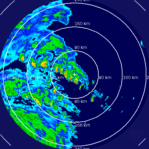
#3526 Postby HURAKAN » Fri Aug 21, 2009 6:47 pm

Image

Heavy rainbands continue to impact Bermuda
0 likes   

magnusson_r
Tropical Wave
Tropical Wave
Posts: 9
Joined: Wed Aug 19, 2009 6:35 pm

#3527 Postby magnusson_r » Fri Aug 21, 2009 6:53 pm

It's expected to be much weakened by the cooler waters on Sunday:

http://www.cbc.ca/world/story/2009/08/1 ... ml?ref=rss

Same item indicates it will remain well offshore between Sable Island and Guysborough county.

Looks like surfers should be careful, though.
Last edited by magnusson_r on Fri Aug 21, 2009 6:55 pm, edited 1 time in total.
0 likes   

User avatar
HurricaneBelle
S2K Supporter
S2K Supporter
Posts: 1179
Joined: Sun Aug 27, 2006 6:12 pm
Location: Clearwater, FL

Re: ATL: HURRICANE BILL (03L)

#3528 Postby HurricaneBelle » Fri Aug 21, 2009 6:53 pm

kat61 wrote:Thanks Macrocane! any time I hear 'stall' think of 'Agnes-1972'.makes me nervous! so much water!


Agnes was a remnant depression that stalled over land, a la Allison 2001 and Alberto 1994. Not similar at all to Bill or any prognosis for Bill.
0 likes   

Derek Ortt

Re:

#3529 Postby Derek Ortt » Fri Aug 21, 2009 7:09 pm

magnusson_r wrote:It's expected to be much weakened by the cooler waters on Sunday:

http://www.cbc.ca/world/story/2009/08/1 ... ml?ref=rss

Same item indicates it will remain well offshore between Sable Island and Guysborough county.

Looks like surfers should be careful, though.


thats great that it says that. However, all forecasts have this as a hurricane. Also, you CANNOT draw a straight line between forecast points. A mroe accurate representation would be to fit a cubic spline to the forecast points, as it would capture the curve far better
0 likes   

User avatar
x-y-no
Category 5
Category 5
Posts: 8359
Age: 65
Joined: Wed Aug 11, 2004 12:14 pm
Location: Fort Lauderdale, FL

Re:

#3530 Postby x-y-no » Fri Aug 21, 2009 7:09 pm

magnusson_r wrote:It's expected to be much weakened by the cooler waters on Sunday:

http://www.cbc.ca/world/story/2009/08/1 ... ml?ref=rss

Same item indicates it will remain well offshore between Sable Island and Guysborough county.

Looks like surfers should be careful, though.


Well, I'd say there are far better sources of information than a CBC article dated last Wednesday. And the forecaster quoted in that article is speaking with absurd precision. Tropical cyclone track forecasting isn't even remotely that precise. That's why they publish the cone, not just the forecast track.
0 likes   

kat61
Tropical Depression
Tropical Depression
Posts: 87
Joined: Tue Aug 11, 2009 4:32 pm
Location: Hampstead,NC

Re: ATL: HURRICANE BILL (03L)

#3531 Postby kat61 » Fri Aug 21, 2009 7:22 pm

HurricaneBelle wrote:
kat61 wrote:Thanks Macrocane! any time I hear 'stall' think of 'Agnes-1972'.makes me nervous! so much water!


Agnes was a remnant depression that stalled over land, a la Allison 2001 and Alberto 1994. Not similar at all to Bill or any prognosis for Bill.


Thanks Belle...I was thinking if Bill made landfall anywhere in the NE US or CAN he would meet
the ridge and stall. Would create a water/flood event for the area
0 likes   

magnusson_r
Tropical Wave
Tropical Wave
Posts: 9
Joined: Wed Aug 19, 2009 6:35 pm

#3532 Postby magnusson_r » Fri Aug 21, 2009 7:23 pm

Well, I think it was a very responsible item warning surfers about the high waves. Lots of rookie surfers will be out there trying to ride those big waves, and could get more than they bargained for.

The local media have become much more careful about warning the public since Juan 6 years ago.

As for track, the CBC weather forecast 1 hour ago still calls for this storm to remain offshore and not to make landfall until it reaches NFLD, at which point it'll be pretty much blown out.

I haven't seen any forecast that puts landfall near Halifax, which is the most densely pop. area.
0 likes   

User avatar
x-y-no
Category 5
Category 5
Posts: 8359
Age: 65
Joined: Wed Aug 11, 2004 12:14 pm
Location: Fort Lauderdale, FL

Re:

#3533 Postby x-y-no » Fri Aug 21, 2009 7:30 pm

magnusson_r wrote:As for track, the CBC weather forecast 1 hour ago still calls for this storm to remain offshore and not to make landfall until it reaches NFLD, at which point it'll be pretty much blown out.

I haven't seen any forecast that puts landfall near Halifax, which is the most densely pop. area.


Well that is the highest probability track, but it's just that: probability. There is a moderate chance that the storm will track more to the left, which would mean more severe conditions for Nova Scotia.
0 likes   

User avatar
HURAKAN
Professional-Met
Professional-Met
Posts: 46086
Age: 38
Joined: Thu May 20, 2004 4:34 pm
Location: Key West, FL
Contact:

#3534 Postby HURAKAN » Fri Aug 21, 2009 7:32 pm

363
WHXX01 KWBC 220030
CHGHUR
TROPICAL CYCLONE GUIDANCE MESSAGE
NWS TPC/NATIONAL HURRICANE CENTER MIAMI FL
0030 UTC SAT AUG 22 2009

DISCLAIMER...NUMERICAL MODELS ARE SUBJECT TO LARGE ERRORS.
PLEASE REFER TO NHC OFFICIAL FORECASTS FOR TROPICAL CYCLONE
AND SUBTROPICAL CYCLONE INFORMATION.

ATLANTIC OBJECTIVE AIDS FOR

TROPICAL CYCLONE BILL (AL032009) 20090822 0000 UTC

...00 HRS... ...12 HRS... ...24 HRS. .. ...36 HRS...
090822 0000 090822 1200 090823 0000 090823 1200

LAT LON LAT LON LAT LON LAT LON
BAMS 30.2N 67.1W 33.4N 68.2W 37.3N 67.1W 41.1N 64.4W
BAMD 30.2N 67.1W 33.0N 68.2W 36.5N 67.7W 40.5N 65.5W
BAMM 30.2N 67.1W 33.1N 68.4W 36.7N 67.8W 40.7N 65.5W
LBAR 30.2N 67.1W 33.5N 67.8W 37.2N 67.4W 40.9N 65.3W
SHIP 90KTS 90KTS 93KTS 89KTS
DSHP 90KTS 90KTS 93KTS 89KTS

...48 HRS... ...72 HRS... ...96 HRS. .. ..120 HRS...
090824 0000 090825 0000 090826 0000 090827 0000

LAT LON LAT LON LAT LON LAT LON
BAMS 43.9N 60.7W 45.5N 47.8W 46.2N 33.1W 48.9N 18.9W
BAMD 44.1N 61.2W 48.5N 42.0W 50.0N 16.6W 48.6N 2.3W
BAMM 44.0N 61.4W 47.2N 44.5W 48.0N 22.3W 49.4N 8.3W
LBAR 44.3N 60.8W 47.6N 39.0W .0N .0W .0N .0W
SHIP 78KTS 47KTS 18KTS 0KTS
DSHP 78KTS 43KTS 0KTS 0KTS

...INITIAL CONDITIONS...
LATCUR = 30.2N LONCUR = 67.1W DIRCUR = 345DEG SPDCUR = 18KT
LATM12 = 26.9N LONM12 = 65.8W DIRM12 = 334DEG SPDM12 = 17KT
LATM24 = 24.3N LONM24 = 63.8W
WNDCUR = 90KT RMAXWD = 20NM WNDM12 = 100KT
CENPRS = 957MB OUTPRS = 1012MB OUTRAD = 240NM SDEPTH = D
RD34NE = 240NM RD34SE = 200NM RD34SW = 100NM RD34NW = 175NM

$$
NNNN

0 likes   

The Eye Wall

Re: ATL: HURRICANE BILL (03L)

#3535 Postby The Eye Wall » Fri Aug 21, 2009 7:41 pm

Wow, what a difference 48 hours makes. Bill is in the jaws now. It won't be long.....

Bill has a very large circulation. Look at the canopy! The core is slowly desolving as well. It appears as though the dry air has erroded the western eye wall. Also notice how the cloud tops are warming. Still a dangerous hurricane, nonetheless. You can also see how the outflow of the hurricane isn't nearly as impressive on the southern side. Thankfully, IMO, Bill will be hard pressed to reach Cat. 3 again.

Image
0 likes   

kat61
Tropical Depression
Tropical Depression
Posts: 87
Joined: Tue Aug 11, 2009 4:32 pm
Location: Hampstead,NC

Re: ATL: HURRICANE BILL (03L)

#3536 Postby kat61 » Fri Aug 21, 2009 7:48 pm

The Eye Wall wrote:Wow, what a difference 48 hours makes. Bill is in the jaws now. It won't be long.....

Bill has a very large circulation. Look at the canopy! The core is slowly desolving as well. It appears as though the dry air has erroded the western eye wall. Also notice how the cloud tops are warming. Still a dangerous hurricane, nonetheless. You can also see how the outflow of the hurricane isn't nearly as impressive on the southern side. Thankfully, IMO, Bill will be hard pressed to reach Cat. 3 again.

Image


thanks for the visual!
0 likes   

User avatar
RNGR
Military Member
Military Member
Posts: 153
Joined: Sun Jul 19, 2009 1:13 pm
Location: Ft. Benning Ga

Re:

#3537 Postby RNGR » Fri Aug 21, 2009 7:49 pm

magnusson_r wrote:
As for track, the CBC weather forecast 1 hour ago still calls for this storm to remain offshore and not to make landfall until it reaches NFLD, at which point it'll be pretty much blown out.

I haven't seen any forecast that puts landfall near Halifax, which is the most densely pop. area.


forcast tracks are NEVER 100% correct. especially when the hurricane is at this distance from the said location.

As for the intensity, the NHC calls for Bill to possibly gain strength in the next 12 hours and has bill as a 75kt cane off the coast of Nova Scotia. Dont forget storm surge.
0 likes   

User avatar
Stephanie
S2K Supporter
S2K Supporter
Posts: 23843
Age: 63
Joined: Thu Feb 06, 2003 9:53 am
Location: Glassboro, NJ

Re: ATL: HURRICANE BILL (03L)

#3538 Postby Stephanie » Fri Aug 21, 2009 8:01 pm

I went for a cigarette break at work in Atlantic City, NJ. The smoking area overlooks the beach. There were some white caps already out in the ocean. The waves were starting to look a bit rough and high already. I ALMOST wish that I was going to work tomorrow to see what the ocean looks like.
0 likes   

magnusson_r
Tropical Wave
Tropical Wave
Posts: 9
Joined: Wed Aug 19, 2009 6:35 pm

#3539 Postby magnusson_r » Fri Aug 21, 2009 8:06 pm

RNGR:

Storm surge is one thing, hurricane making landfall is quite another. People in Nova Scotia are used to dealing with storm surge -- but not hurricanes, generally speaking.
0 likes   

kat61
Tropical Depression
Tropical Depression
Posts: 87
Joined: Tue Aug 11, 2009 4:32 pm
Location: Hampstead,NC

Re: ATL: HURRICANE BILL (03L)

#3540 Postby kat61 » Fri Aug 21, 2009 8:08 pm

Stephanie wrote:I went for a cigarette break at work in Atlantic City, NJ. The smoking area overlooks the beach. There were some white caps already out in the ocean. The waves were starting to look a bit rough and high already. I ALMOST wish that I was going to work tomorrow to see what the ocean looks like.


pretend you have work- and just go to the beach..... so much energy there!
0 likes   


Return to “2009”

Who is online

Users browsing this forum: No registered users and 1 guest