New large wave behind Bill east of Lesser Antilles

This is the general tropical discussion area. Anyone can take their shot at predicting a storms path.

Moderator: S2k Moderators

Forum rules

The posts in this forum are NOT official forecasts and should not be used as such. They are just the opinion of the poster and may or may not be backed by sound meteorological data. They are NOT endorsed by any professional institution or STORM2K. For official information, please refer to products from the National Hurricane Center and National Weather Service.

Help Support Storm2K
Message
Author
jinftl
Category 5
Category 5
Posts: 4312
Joined: Tue Aug 31, 2004 4:47 pm
Location: fort lauderdale, fl

Re: New large wave behind Bill wsw of cv islands

#221 Postby jinftl » Sat Aug 22, 2009 6:18 pm

Latest model run (18z) again shows a low tracking system.....not forming until the end of the upcoming week....maybe we are seeing the beginning of consistency between consecutive model runs....this run shows a system hugging 10N at least until 50W.

Image


KWT wrote:
Sanibel wrote:The negative MJO hand is on the ITCZ right now.


Funny you should say that but actually we still are in a fairly favorable MJO phase, the models a few days ago appear to have been much too agressive, yesterdays models for example showed us staying in a weak positive mode till at least the 10th of September then slowly negative conditions take over...but you can't blame the MJO on this one! :wink:

jinftl, the 06z is the only run I've seen from the GFS in the last few days to have anything that low, most runs have had that feature north of 15N before 40W and ready to recurve. Will be interesting to see what happens though and whether its a trend the GFS continues.
0 likes   

Sanibel
Category 5
Category 5
Posts: 10375
Joined: Mon Aug 30, 2004 11:06 pm
Location: Offshore SW Florida

Re: New large wave behind Bill wsw of cv islands

#222 Postby Sanibel » Sat Aug 22, 2009 10:58 pm

All eyes to GFS.
0 likes   

Aric Dunn
Category 5
Category 5
Posts: 21238
Age: 42
Joined: Sun Sep 19, 2004 9:58 pm
Location: Ready for the Chase.
Contact:

#223 Postby Aric Dunn » Sat Aug 22, 2009 11:25 pm

I have not read anything for the last couple days on here for this .. but the shear over the wave is going to help with fire convection especially tomorrow as the wave approached the shear axis. after that if a surface feature develops the tutt that is now starting to accelerate westward may eventually get far enough away to allow a better environment for something to get going ..
0 likes   

DreamworksSKG

#224 Postby DreamworksSKG » Sun Aug 23, 2009 5:56 am

IF one of these waves coming off Africa develops around the Bahamas - and a bit further west (i.e.) not so close to Africa--would there be more of a shot of an east coast run storm?

I have heard the ones that develop closer to africa tend to recurve.
0 likes   

User avatar
HURAKAN
Professional-Met
Professional-Met
Posts: 46086
Age: 38
Joined: Thu May 20, 2004 4:34 pm
Location: Key West, FL
Contact:

Area to watch for possible development - East Coast/Bahamas

#225 Postby HURAKAN » Sun Aug 23, 2009 9:14 am

Elsewhere in the tropics
There are no threat areas in the Atlantic worth mentioning today. Most of the models are calling for the possible development of a tropical cyclone in the waters between the Bahamas and North Carolina on Wednesday or Thursday. There could be two triggers for tropical cyclone formation--the remains of the cold front that pushed off the U.S. East Coast this morning, plus a tropical wave that is currently approaching the northern Lesser Antilles Islands. We will also need to watch the region off the coast of Africa this week.

Jeff Masters


Image
0 likes   

User avatar
HURAKAN
Professional-Met
Professional-Met
Posts: 46086
Age: 38
Joined: Thu May 20, 2004 4:34 pm
Location: Key West, FL
Contact:

#226 Postby HURAKAN » Sun Aug 23, 2009 9:18 am

Image

Not a good scenario to have a High pressure over the East Coast
0 likes   

User avatar
gatorcane
S2K Supporter
S2K Supporter
Posts: 23692
Age: 47
Joined: Sun Mar 13, 2005 3:54 pm
Location: Boca Raton, FL

#227 Postby gatorcane » Sun Aug 23, 2009 9:25 am

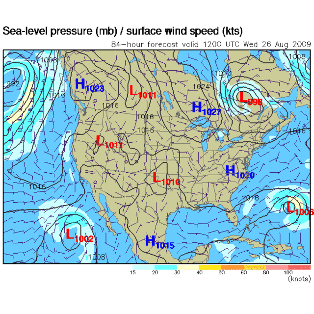
CMC still liking this area for development and showing a recurve east of Florida and the US.

The 06Z GFS shows a system maybe impacting the Carolinas but shows it weak at this time...

00Z ECMWF shows development also --- recurve away from US, maybe impacting Halifax in Novia Scotia again.

definitely good to start this thread as some kind of low pressure looks like it will develop. Will Novia Scotia be the hurricane magnet this year I wonder?!?!?

Image
0 likes   

User avatar
HURAKAN
Professional-Met
Professional-Met
Posts: 46086
Age: 38
Joined: Thu May 20, 2004 4:34 pm
Location: Key West, FL
Contact:

#228 Postby HURAKAN » Sun Aug 23, 2009 10:01 am

Image

This area already getting some consideration
0 likes   

User avatar
vbhoutex
Storm2k Executive
Storm2k Executive
Posts: 29113
Age: 73
Joined: Wed Oct 09, 2002 11:31 pm
Location: Cypress, TX
Contact:

Re:

#229 Postby vbhoutex » Sun Aug 23, 2009 10:49 am

DreamworksSKG wrote:IF one of these waves coming off Africa develops around the Bahamas - and a bit further west (i.e.) not so close to Africa--would there be more of a shot of an east coast run storm?

I have heard the ones that develop closer to africa tend to recurve.

Because the TC's that develop closer to Africa have a larger expanse of water to cross, they also have a better chance of feeling any weakness in the Bermuda and Azores highs and heading to that weakness and out to sea as opposed to continuing a more Westerly track. Anything that might develop "closer to home" has less of a chance of finding those weaknesses and therefore may have a better chance at an "east coast run". However, with the current troughiness along the Eastern Seaboard fish storms are a better bet than landfalling storms if one is talking about the Atlantic. Remember that it only takes one to defy this and make things miserable for someone somewhere.
0 likes   

Frank2
Category 5
Category 5
Posts: 4061
Joined: Mon Jul 25, 2005 12:47 pm

#230 Postby Frank2 » Sun Aug 23, 2009 10:52 am

I'll stick with my "10 day" guess back on Friday, since the large (and I mean large) ULL in the Central Atlantic is preventing any wave from developing ATTM - that and the negative MJO is good news for now...

http://www.goes.noaa.gov/HURRLOOPS/huwvloop.html

Thankfully...

Frank
Last edited by Frank2 on Sun Aug 23, 2009 10:57 am, edited 1 time in total.
0 likes   

jinftl
Category 5
Category 5
Posts: 4312
Joined: Tue Aug 31, 2004 4:47 pm
Location: fort lauderdale, fl

Re: Re:

#231 Postby jinftl » Sun Aug 23, 2009 10:53 am

And don't forget....not all hurricanes form to the east of the u.s....esp later in the season, we need to look to our south as well (i.e., mitch, irene, wilma)

vbhoutex wrote:
DreamworksSKG wrote:IF one of these waves coming off Africa develops around the Bahamas - and a bit further west (i.e.) not so close to Africa--would there be more of a shot of an east coast run storm?

I have heard the ones that develop closer to africa tend to recurve.

Because the TC's that develop closer to Africa have a larger expanse of water to cross, they also have a better chance of feeling any weakness in the Bermuda and Azores highs and heading to that weakness and out to sea as opposed to continuing a more Westerly track. Anything that might develop "closer to home" has less of a chance of finding those weaknesses and therefore may have a better chance at an "east coast run". However, with the current troughiness along the Eastern Seaboard fish storms are a better bet than landfalling storms if one is talking about the Atlantic. Remember that it only takes one to defy this and make things miserable for someone somewhere.
0 likes   

User avatar
HURAKAN
Professional-Met
Professional-Met
Posts: 46086
Age: 38
Joined: Thu May 20, 2004 4:34 pm
Location: Key West, FL
Contact:

#232 Postby HURAKAN » Sun Aug 23, 2009 10:54 am

Image

Image

Image

Image

Image

If it doesn't develop, it wasn't because the models didn't want!!!
0 likes   

Derek Ortt

#233 Postby Derek Ortt » Sun Aug 23, 2009 11:05 am

this isnt the lead pipe cinch though that Bill was

if it develops, depends where and how the trough is
0 likes   

User avatar
srainhoutx
S2K Supporter
S2K Supporter
Posts: 6919
Age: 67
Joined: Sun Jan 14, 2007 11:34 am
Location: Haywood County, NC
Contact:

Re: Re:

#234 Postby srainhoutx » Sun Aug 23, 2009 11:06 am

jinftl wrote:And don't forget....not all hurricanes form to the east of the u.s....esp later in the season, we need to look to our south as well (i.e., mitch, irene, wilma)


Let's not forget Carla (1961) and Celia (1970). :wink:
0 likes   

User avatar
KWT
Category 5
Category 5
Posts: 31415
Joined: Tue Aug 17, 2004 11:02 am
Location: UK!!!

#235 Postby KWT » Sun Aug 23, 2009 12:10 pm

Frank, as I said before there is NO negative MJO signal, its still currently in a favorable phase over the Atlantic. The models are shifting about in that respect but its certainly not a negative feature at the moment thats for sure.
0 likes   

User avatar
cycloneye
Admin
Admin
Posts: 145604
Age: 68
Joined: Thu Oct 10, 2002 10:54 am
Location: San Juan, Puerto Rico

Re: Area to watch for possible development - East Coast/Bahamas

#236 Postby cycloneye » Sun Aug 23, 2009 12:11 pm

12z CMC still develops it and tracks towards Carolinas.

http://moe.met.fsu.edu/cgi-bin/cmctc2.c ... =Animation

Image
0 likes   

User avatar
BigA
Professional-Met
Professional-Met
Posts: 1317
Joined: Sun Jul 24, 2005 10:56 pm

Re: Area to watch for possible development - East Coast/Bahamas

#237 Postby BigA » Sun Aug 23, 2009 12:11 pm

Derek Ortt wrote:this isnt the lead pipe cinch though that Bill was

if it develops, depends where and how the trough is


Derek, do you mean the lack of a "lead pipe cinch" for development, or recurvature if development occurs? Thank you.
0 likes   

User avatar
KWT
Category 5
Category 5
Posts: 31415
Joined: Tue Aug 17, 2004 11:02 am
Location: UK!!!

#238 Postby KWT » Sun Aug 23, 2009 12:12 pm

Yeah this one seems to be dependant on the troughs digging down and being positive enough to recurve it, which seems to be hard to tell given its looking increasingly possible the first feature won't get the job done.

Hard to call to be honest, the whole set-up is somewhat confusing to me!
0 likes   

Derek Ortt

#239 Postby Derek Ortt » Sun Aug 23, 2009 12:14 pm

Bill was a shoe-in to develop

this one really only has CMC support (the other models show more of a broad area of low-pressure or a sharp wave, not a tropical cyclone)
0 likes   

User avatar
KWT
Category 5
Category 5
Posts: 31415
Joined: Tue Aug 17, 2004 11:02 am
Location: UK!!!

#240 Postby KWT » Sun Aug 23, 2009 12:20 pm

Yeah Derek this one is rather uncertain, though the GFS does briefly have a closed low, as did the 0z ECM. I suspect the models don't have a very good grasp on this system yet, since there really isn't a lot to really go on just yet.
0 likes   


Return to “Talkin' Tropics”

Who is online

Users browsing this forum: cheezyWXguy, Hurricane2022, Ian2401, Javlin, prairie2, zzzh and 74 guests