
ATL: TROPICAL DEPRESSION DANNY (05L)
Moderator: S2k Moderators
-
wxman57

- Moderator-Pro Met

- Posts: 23172
- Age: 68
- Joined: Sat Jun 21, 2003 8:06 pm
- Location: Houston, TX (southwest)
Re: ATL: Invest 92L - Computer Models
Thought you might want to see the GFS's projection for mean 700-400mb (10,000-20,000 ft) wind flow for Wednesday morning. The difference between the GFS and ECMWF appears to be in the movement of the closed low over the Gulf coast. The GFS is much more progressive with the low, moving it eastward a lot faster than the ECMWF. That's why the GFS curves the system out to the north, well off the east U.S. coast. I'd tend to trust the European more than the GFS, though, with a closer brush of the east coast or a landfall in NC.
0 likes

Re: Re:
do you mean 2 miles - 300 miles or 200 miles - 300 miles? LOL
Watch the trend....between models and within individual models between runs....not saying the 2 mile end of closest florida approach is being shown.....but not saying the 300 miles closest approach is being represented either. Example....6z NAM run showed a system at 29N 71W, 12z NAM showed a system at 28N 75W
Watch the trend....between models and within individual models between runs....not saying the 2 mile end of closest florida approach is being shown.....but not saying the 300 miles closest approach is being represented either. Example....6z NAM run showed a system at 29N 71W, 12z NAM showed a system at 28N 75W
Blown_away wrote:deltadog03 wrote:gatorcane wrote:Keep in mind if it takes long for this to develop that consensus will just keep shifting left.
I expect things will change with that track guidance as its going to be a few days before anything gets going, so they should shift left.
I agree 100% IMO this could easily shift back towards florida to the carolinas. I think euro/cmc looks pretty good (from a very early look at things) In fact I think the EURO got closer to the FL coast on the 12z run
I don't know if I would call it close to Florida, I think the EURO's closest point is @ 2-300 miles.
0 likes
-
MGC

- S2K Supporter

- Posts: 5940
- Joined: Sun Mar 23, 2003 9:05 pm
- Location: Pass Christian MS, or what is left.
Re: ATL: Invest 92L
Code Orange? I don't see 92L developing with the realtive shear that is affecting the disturbance. I'd only give it a 10 % chance. Once the ULL gets out the picture then perhaps.......MGC
0 likes

Re: ATL: Invest 92L
Dr. Jeff Masters makes mention of shear beginning to drop off tomorrow night/wed am (and he is known for not hyping systems....radical, i know...lol):
A tropical wave with a moderate amount of shower activity is moving west-northwest at 20 - 25 mph and is approaching the northern Lesser Antilles Islands. This wave was designated "Invest 92" (92L) by NHC this morning. The wave is under about 20 - 30 knots of wind shear due the strong upper-level winds from the west. These winds are being created by the counter-clockwise flow of air around an upper-level cold-cored low north of Puerto Rico. This low is expected to move west-southwest and slowly weaken over the next two days, allowing shear to drop to the moderate 10 - 20 knot range beginning Tuesday night, according to the SHIPS model.
By Wednesday, the upper low is predicted to be weak enough and far enough away from 92L that it will have a chance to develop. Most of the models show some degree of development of 92L by Thursday, when it is expected to be a few hundred miles off the coast of South Carolina. This wave could turn northward and give a wet weekend to New England, though it is too early to be confident of this. NHC is giving 92L a low (less than 30% chance) of developing into a tropical depression by Wednesday morning. The upper-level low will create plenty of wind shear and dump cold, dry air into 92L over the next two days, so Wednesday is probably the earliest we can expect the system to begin organizing into a tropical depression.
MGC wrote:Code Orange? I don't see 92L developing with the realtive shear that is affecting the disturbance. I'd only give it a 10 % chance. Once the ULL gets out the picture then perhaps.......MGC
0 likes
-
cycloneye

- Admin

- Posts: 149276
- Age: 69
- Joined: Thu Oct 10, 2002 10:54 am
- Location: San Juan, Puerto Rico
Re: ATL: Invest 92L
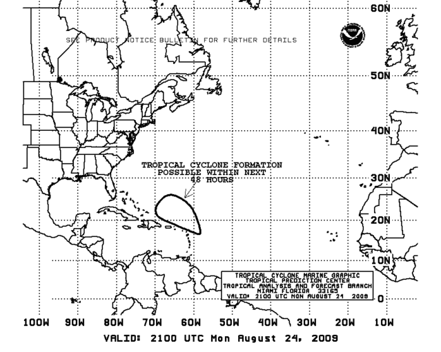
753
ABNT20 KNHC 242331
TWOAT
TROPICAL WEATHER OUTLOOK
NWS TPC/NATIONAL HURRICANE CENTER MIAMI FL
800 PM EDT MON AUG 24 2009
FOR THE NORTH ATLANTIC...CARIBBEAN SEA AND THE GULF OF MEXICO...
SHOWERS AND THUNDERSTORMS REMAIN DISORGANIZED IN ASSOCIATION WITH A
TROPICAL WAVE INTERACTING WITH AN UPPER-LEVEL LOW ABOUT 300 MILES
EAST-NORTHEAST OF THE LEEWARD ISLAND. UPPER-LEVEL WINDS MAY BECOME
MORE FAVORABLE FOR SLOW DEVELOPMENT OF THIS SYSTEM OVER THE NEXT
COUPLE OF DAYS AS IT MOVES TOWARD THE WEST-NORTHWEST AT AROUND 25
MPH. THERE IS A MEDIUM CHANCE...30 TO 50 PERCENT...OF THIS SYSTEM
BECOMING A TROPICAL CYCLONE DURING THE NEXT 48 HOURS.
0 likes
-
Dean4Storms
- S2K Supporter
- Posts: 6358
- Age: 63
- Joined: Sun Aug 31, 2003 1:01 pm
- Location: Miramar Bch. FL


-
sfwx

- Category 1

- Posts: 371
- Age: 60
- Joined: Thu Sep 04, 2003 1:53 pm
- Location: Rural St. Lucie County, Fl
Re: ATL: Invest 92L
AREA FORECAST DISCUSSION
NATIONAL WEATHER SERVICE MELBOURNE FL
118 PM EDT MON AUG 24 2009
.DISCUSSION...
WED...CONTINUED SLIGHT RETROGRADE OF MID/UPPER LEVEL TROUGH WILL
ALLOW RIDGING TO BUILD FROM THE WESTERN ATLANTIC ACROSS FLORIDA.
THE MODELS SHOW HIGH MOISTURE ASSOCIATED WITH THE WEAKENING
FRONTAL BOUNDARY PUSHING WEST AND POCKET OF SLIGHTLY DRIER AIR
SPREADING ACROSS THE AREA.
SURFACE RIDGE AXIS TO OUR NORTH WITH A TROPICAL WAVE/SURFACE LOW
OUT TOWARDS 70W WILL PROVIDE NORTHEAST-EAST WINDS. THIS FLOW
PATTERN DURING THE WET SEASON IS USUALLY DRIER THAN NORMAL AND THE
MAIN CHANCES FOR AFTERNOON STORMS WILL SHIFT TO THE INTERIOR/WEST
SIDE OF THE PENINSULA. THE LATEST MOS POPS ARE 30-40 PERCENT BUT
WILL KEEP CURRENT 30 POP FORECAST INTACT UNTIL THE MODELS BECOME
MORE CONSISTENT WITH THE APPROACHING LOW PRESSURE WAVE.
PREVIOUS DISCUSSION
THURS-SUN...MUCH UNCERTAINTY LIES IN THE LONG RANGE FORECAST AS
MODELS ARE HAVING A DIFFICULT TIME RESOLVING THE PLACEMENT AND
DEVELOPMENT OF THE TROPICAL WAVE THAT WILL BE APPROACHING CENTRAL
FLORIDA. THE GFS NOW WANTS TO DRAG THE WAVE INTO CENTRAL FLORIDA
WHICH WOULD GREATLY INCREASE MOISTURE AND RAIN CHANCES FOR THURS
INTO FRI. HOWEVER THE MORE CONSISTENT ECMWF KEEPS THE WAVE JUST EAST
OF THE AREA AND DEVELOPS IT INTO A CLOSED LOW SYSTEM AS IT BUILDS
NORTH LATE WEEK INTO THE WEEKEND. WILL STICK WITH THE ECMWF FOR NOW
AND HOLD ONTO NEAR NORMAL POPS AROUND 40% FOR MUCH OF THE EXTENDED.
HOWEVER WILL HAVE TO WATCH HOW FUTURE MODEL RUNS HANDLE THIS SYSTEM
AS PLACEMENT WILL BE KEY TO HOW RAIN CHANCES WILL PLAY OUT.
SHORT TERM/AVIATION...WIMMER
LONG TERM....LASCODY
0 likes


Re: ATL: Invest 92L - Computer Models
18Z NAM really likes future Danny! (yes I know its the NAM)

0 likes
-
Blown Away

- S2K Supporter
- Posts: 10253
- Joined: Wed May 26, 2004 6:17 am
Re:
deltadog03 wrote:The shear is going to have to really relax before this can do whatever its gonna do... The shear is forecasted to lessen fairly quickly. As, I posted back on page 3, the models do build a very nice size upper anticyclone on top of this once it hits the bahamas. As far as track, its really going to depend on that trof split and where the upper low thats over the SE moves.
Deltadog, how can we expect 92L to develope when it's moving at 25mph?
0 likes
Re: ATL: Invest 92L - Computer Models
Just do not see 'it' hitting the fl coast, due to the placement of the high, agree/disagree? close enough though to ruin a Friday fishing trip off west palm on the first day of a much needed vacation.
0 likes
Re: ATL: Invest 92L
Quikscat from ~ 2.5 hours ago.

Conetmporaneous IR image for comparision purposes:


Conetmporaneous IR image for comparision purposes:

0 likes
Re: ATL: Invest 92L - Computer Models
The positioning of the high pressure is interesting...
ronjon wrote:18Z NAM really likes future Danny! (yes I know its the NAM)
0 likes
-
weatherwindow

- Category 4

- Posts: 904
- Joined: Mon Sep 20, 2004 9:48 am
- Location: key west/ft lauderdale
Re:
Derek Ortt wrote:have seen many TCs intensify very quickly when moving at 25KT.
the speed is not a problem at all if there is no shear
derek....given forward speed and proximity, what are the chances that cyclogenesis occurs further west than, say, 73degw or so , as could be implied by the 72hr tafb surface forcast??...any plausible chance of missing the trough and impacting the southern half of the penisula?.......rich
0 likes
-
Blown Away
- S2K Supporter
- Posts: 10253
- Joined: Wed May 26, 2004 6:17 am
Re: ATL: Invest 92L
sfwx wrote:AREA FORECAST DISCUSSION
NATIONAL WEATHER SERVICE MELBOURNE FL
118 PM EDT MON AUG 24 2009
PREVIOUS DISCUSSION
THURS-SUN...MUCH UNCERTAINTY LIES IN THE LONG RANGE FORECAST AS
MODELS ARE HAVING A DIFFICULT TIME RESOLVING THE PLACEMENT AND
DEVELOPMENT OF THE TROPICAL WAVE THAT WILL BE APPROACHING CENTRAL
FLORIDA. THE GFS NOW WANTS TO DRAG THE WAVE INTO CENTRAL FLORIDA
WHICH WOULD GREATLY INCREASE MOISTURE AND RAIN CHANCES FOR THURS
INTO FRI. HOWEVER THE MORE CONSISTENT ECMWF KEEPS THE WAVE JUST EAST
OF THE AREA AND DEVELOPS IT INTO A CLOSED LOW SYSTEM AS IT BUILDS
NORTH LATE WEEK INTO THE WEEKEND. WILL STICK WITH THE ECMWF FOR NOW
AND HOLD ONTO NEAR NORMAL POPS AROUND 40% FOR MUCH OF THE EXTENDED.
HOWEVER WILL HAVE TO WATCH HOW FUTURE MODEL RUNS HANDLE THIS SYSTEM
AS PLACEMENT WILL BE KEY TO HOW RAIN CHANCES WILL PLAY OUT.
I guess the "If the wave is shallow" it goes west (GFS) and if there is a "Low pressure center
it will be deeper" and go more poleward (ECMWF).
0 likes
-
cycloneye
- Admin
- Posts: 149276
- Age: 69
- Joined: Thu Oct 10, 2002 10:54 am
- Location: San Juan, Puerto Rico
Re: ATL: Invest 92L
00 UTC Best Track
AL, 92, 2009082500, , BEST, 0, 178N, 599W, 20, 1012, DB
ftp://ftp.tpc.ncep.noaa.gov/atcf/tcweb/ ... 009.invest
AL, 92, 2009082500, , BEST, 0, 178N, 599W, 20, 1012, DB
ftp://ftp.tpc.ncep.noaa.gov/atcf/tcweb/ ... 009.invest
0 likes
-
cycloneye
- Admin
- Posts: 149276
- Age: 69
- Joined: Thu Oct 10, 2002 10:54 am
- Location: San Juan, Puerto Rico
Re: ATL: Invest 92L - Computer Models
00 UTC Bam Models
SHIP continues to forecast hurricane intensity by 96 hours.
WHXX01 KWBC 250044
CHGHUR
TROPICAL CYCLONE GUIDANCE MESSAGE
NWS TPC/NATIONAL HURRICANE CENTER MIAMI FL
0044 UTC TUE AUG 25 2009
DISCLAIMER...NUMERICAL MODELS ARE SUBJECT TO LARGE ERRORS.
PLEASE REFER TO NHC OFFICIAL FORECASTS FOR TROPICAL CYCLONE
AND SUBTROPICAL CYCLONE INFORMATION.
ATLANTIC OBJECTIVE AIDS FOR
DISTURBANCE INVEST (AL922009) 20090825 0000 UTC
...00 HRS... ...12 HRS... ...24 HRS. .. ...36 HRS...
090825 0000 090825 1200 090826 0000 090826 1200
LAT LON LAT LON LAT LON LAT LON
BAMS 17.8N 59.9W 20.2N 63.6W 22.7N 66.2W 25.0N 68.6W
BAMD 17.8N 59.9W 19.8N 62.2W 21.9N 64.3W 23.8N 66.1W
BAMM 17.8N 59.9W 19.5N 62.8W 21.3N 65.2W 22.9N 67.1W
LBAR 17.8N 59.9W 19.6N 62.9W 21.4N 65.4W 23.0N 67.6W
SHIP 20KTS 24KTS 29KTS 36KTS
DSHP 20KTS 24KTS 29KTS 36KTS
...48 HRS... ...72 HRS... ...96 HRS. .. ..120 HRS...
090827 0000 090828 0000 090829 0000 090830 0000
LAT LON LAT LON LAT LON LAT LON
BAMS 27.2N 70.4W 30.9N 72.3W 34.4N 71.8W 38.5N 66.8W
BAMD 25.3N 67.9W 27.6N 70.5W 30.1N 71.3W 34.2N 69.0W
BAMM 24.4N 68.9W 26.7N 71.7W 29.1N 72.6W 32.1N 71.5W
LBAR 24.4N 69.3W 26.2N 71.4W 27.8N 72.7W 29.8N 73.5W
SHIP 44KTS 56KTS 66KTS 72KTS
DSHP 44KTS 56KTS 66KTS 72KTS
...INITIAL CONDITIONS...
LATCUR = 17.8N LONCUR = 59.9W DIRCUR = 290DEG SPDCUR = 20KT
LATM12 = 16.5N LONM12 = 56.0W DIRM12 = 288DEG SPDM12 = 20KT
LATM24 = 15.2N LONM24 = 52.0W
WNDCUR = 20KT RMAXWD = 50NM WNDM12 = 20KT
CENPRS = 1012MB OUTPRS = 1013MB OUTRAD = 120NM SDEPTH = M
RD34NE = 0NM RD34SE = 0NM RD34SW = 0NM RD34NW = 0NM
0 likes
Who is online
Users browsing this forum: No registered users and 21 guests