RL3AO wrote:
Is that better Aric?

perfect..
Moderator: S2k Moderators
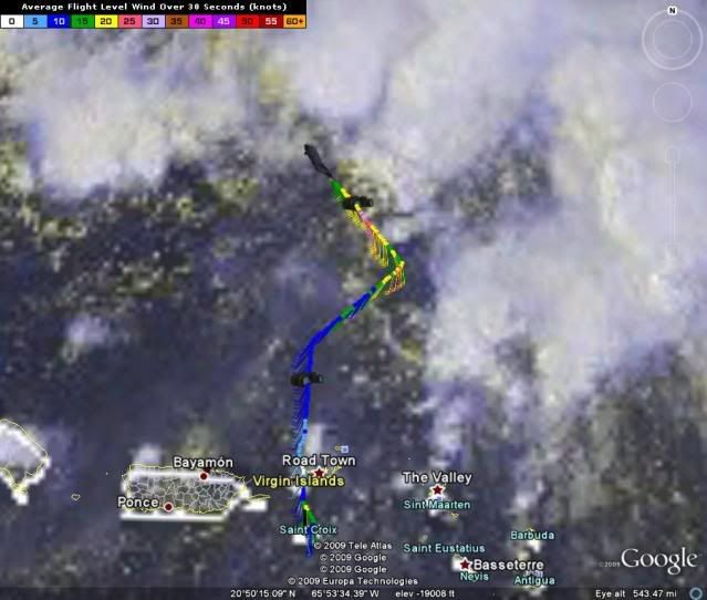
Blown_away wrote:The interaction of a developing tropical system and a dissipating ULL is difficult for me to understand, but the most obvious spin is near 23N / 68W moving generally W. This area is also building convection as we speak.

Blown_away wrote:The interaction of a developing tropical system and a dissipating ULL is difficult for me to understand, but the most obvious spin is near 23N / 68W moving generally W. This area is also building convection as we speak.
http://www.ssd.noaa.gov/goes/east/tatl/loop-avn.html


Derek Ortt wrote:looking at 1km visible imagery, it does appear that there are SW winds. However, this looks to be a broad area of low-pressure and not quite a TC
Code: Select all
TIME        Latit.    Long.    Plane. Prs.   Height   Pressure   Temp   Dew Pt.   Dir, 30s mean   FL    SFMR   Precip   QC
19:20:30z   19.45°N   64.46°W   506.0 hPa   5776m   1002.9 hPa   -6.5°C   -14.4°C   214° @ 010kt   10kt   999kt   999mm   Suspect
19:21:00z   19.48°N   64.45°W   505.8 hPa   5781m   1002.8 hPa   -6.8°C   -14.2°C   220° @ 010kt   10kt   999kt   999mm   Suspect
19:21:30z   19.50°N   64.45°W   506.0 hPa   5773m   1002.8 hPa   -6.6°C   -14.3°C   218° @ 010kt   10kt   999kt   999mm   Suspect
19:22:00z   19.53°N   64.45°W   505.8 hPa   5774m   1002.8 hPa   -6.6°C   -14.3°C   218° @ 010kt   11kt   999kt   999mm   Suspect
19:22:30z   19.56°N   64.45°W   506.0 hPa   5767m   1002.8 hPa   -6.5°C   -14.4°C   225° @ 010kt   10kt   999kt   999mm   Suspect
19:23:00z   19.58°N   64.45°W   505.8 hPa   5776m   1002.8 hPa   -6.7°C   -14.6°C   222° @ 010kt   10kt   999kt   999mm   Suspect
19:23:30z   20.01°N   64.44°W   506.0 hPa   5773m   1002.7 hPa   -6.7°C   -14.8°C   221° @ 012kt   12kt   999kt   999mm   Suspect
19:24:00z   20.04°N   64.44°W   505.8 hPa   5774m   1002.6 hPa   -6.5°C   -15.0°C   219° @ 012kt   12kt   999kt   999mm   Suspect
19:24:30z   20.06°N   64.43°W   505.8 hPa   5779m   1002.7 hPa   -6.5°C   -15.2°C   220° @ 012kt   13kt   999kt   999mm   Suspect
19:25:00z   20.08°N   64.41°W   506.0 hPa   5777m   1002.7 hPa   -6.6°C   -15.3°C   217° @ 013kt   14kt   999kt   999mm   Suspect
19:25:30z   20.10°N   64.39°W   505.9 hPa   5771m   1002.5 hPa   -7.0°C   -15.4°C   219° @ 014kt   14kt   999kt   999mm   Suspect
19:26:00z   20.11°N   64.37°W   505.8 hPa   5770m   1002.5 hPa   -6.5°C   -15.6°C   220° @ 012kt   13kt   999kt   999mm   Suspect
19:26:30z   20.13°N   64.34°W   506.0 hPa   5774m   1002.5 hPa   -6.5°C   -15.7°C   219° @ 012kt   13kt   999kt   999mm   Suspect
19:27:00z   20.15°N   64.32°W   506.0 hPa   5770m   1002.5 hPa   -6.5°C   -15.8°C   219° @ 013kt   13kt   999kt   999mm   Suspect
19:27:30z   20.16°N   64.30°W   506.0 hPa   5773m   1002.5 hPa   -6.5°C   -15.9°C   217° @ 014kt   14kt   999kt   999mm   Suspect
19:28:00z   20.18°N   64.28°W   506.0 hPa   5767m   1002.5 hPa   -6.5°C   -15.9°C   214° @ 014kt   15kt   999kt   999mm   Suspect
19:28:30z   20.20°N   64.26°W   506.0 hPa   5768m   1002.4 hPa   -6.5°C   -16.0°C   218° @ 014kt   15kt   999kt   999mm   Suspect
19:29:00z   20.22°N   64.23°W   505.8 hPa   5771m   1002.6 hPa   -6.7°C   -16.2°C   219° @ 014kt   14kt   999kt   999mm   Suspect
19:29:30z   20.23°N   64.21°W   505.8 hPa   5774m   1002.5 hPa   -7.0°C   -16.2°C   221° @ 014kt   14kt   999kt   999mm   Suspect
19:30:00z   20.25°N   64.19°W   506.2 hPa   5764m   1002.4 hPa   -6.9°C   -16.3°C   216° @ 015kt   15kt   999kt   999mm   Suspect


cycloneye wrote:I see 240 that is WSW.


sandyb wrote:do we know anything yet?
cycloneye wrote:A bunch of 240-235,WSW winds.
URNT15 KNHC 252021
AF302 01AAA INVEST HDOB 10 20090825
201030 2221N 06433W 9774 00303 0117 +240 +155 157017 018 019 004 00
201100 2223N 06434W 9772 00304 0117 +240 +156 157018 019 018 004 00
201130 2224N 06435W 9772 00306 0117 +240 +156 157018 019 018 004 00
201200 2225N 06436W 9772 00304 0117 +240 +157 156018 018 019 002 00
201230 2227N 06437W 9772 00306 0118 +240 +158 153018 018 020 003 00
201300 2228N 06438W 9769 00308 0118 +240 +158 151018 018 017 004 00
201330 2229N 06440W 9772 00305 0118 +240 +159 150017 018 017 004 00
201400 2231N 06441W 9773 00304 0119 +240 +159 153017 018 015 004 00
201430 2232N 06442W 9770 00307 0118 +240 +160 154017 018 017 004 00
201500 2233N 06443W 9767 00310 0118 +240 +160 153018 019 017 004 00
201530 2235N 06444W 9770 00306 0118 +239 +160 150016 017 017 004 00
201600 2236N 06445W 9770 00306 0118 +235 +161 150017 018 016 004 00
201630 2237N 06446W 9770 00304 0117 +235 +161 150019 019 016 005 00
201700 2239N 06448W 9770 00305 0117 +235 +161 152019 020 018 005 00
201730 2240N 06449W 9770 00305 0117 +235 +161 155020 021 019 004 00
201800 2241N 06450W 9770 00305 0116 +235 +161 153021 022 021 005 00
201830 2243N 06451W 9771 00304 0116 +235 +161 153022 022 021 005 00
201900 2244N 06452W 9771 00301 0115 +235 +161 152023 024 024 003 00
201930 2245N 06453W 9773 00300 0115 +235 +160 153023 023 022 005 00
202000 2247N 06455W 9770 00304 0115 +235 +161 151021 022 020 005 00
$$
Users browsing this forum: No registered users and 60 guests