ATL: TROPICAL DEPRESSION DANNY (05L)
Moderator: S2k Moderators

Re: ATL: Invest 92L
that sounds good maybe our high school football season wont be messed up this year
0 likes
-
Evil Jeremy

- S2K Supporter

- Posts: 5463
- Age: 32
- Joined: Mon Apr 10, 2006 2:10 pm
- Location: Los Angeles, CA
Re: ATL: Invest 92L
rrm wrote:has that ever happened where a storm went where none of the models were showing it to go?
If the storm is going somewhere, the models will show it. They might not show it immediately, but the models end up correctly showing where a storm will eventually go. Anyways, this is defiantly not bound to enter the Gulf.
0 likes
-
Jevo

- S2K Supporter
- Posts: 1729
- Age: 47
- Joined: Tue Aug 03, 2004 8:45 pm
- Location: The Flemish Cap
- Contact:
Re: ATL: Invest 92L
cheezyWXguy wrote:We have quite a consensus that leads this up the east coast, and assuming the synoptic setup doesn't change dramatically in the next 2 days, the high pressure to the north of this system is not strong enough far enough west to keep this thing going straight west long enough to hit the gulf. Based on its "location" it would have to move directly west to get to the gulf at a latitude that would allow it to stay over water for a decent amount of time. However, its "movement" now is 315, or NW, meaning it probably won't get there.
Excuse my inexperience.... I noticed you used motion of 315/NW in quotes. How are we able to determine an initial motion w/o a defined center of circulation?
0 likes
-
Evil Jeremy
- S2K Supporter
- Posts: 5463
- Age: 32
- Joined: Mon Apr 10, 2006 2:10 pm
- Location: Los Angeles, CA
Re: ATL: Invest 92L
rrm wrote:that sounds good maybe our high school football season wont be messed up this year
If a storm was in the gulf, the prime area for intensification, the last thing I would be worrying about would be high school football. You would be lucky to even have high school for weeks after a direct hurricane hit lol.
0 likes


-
David in FL

- Tropical Low

- Posts: 28
- Joined: Mon Aug 10, 2009 12:57 am
- Location: Jacksonville Beach, FL
Re: ATL: Invest 92L
Is there any chance of this thing hitting us in NFL or is it to early to tell?
0 likes
-
Evil Jeremy
- S2K Supporter
- Posts: 5463
- Age: 32
- Joined: Mon Apr 10, 2006 2:10 pm
- Location: Los Angeles, CA
Re: ATL: Invest 92L
David in FL wrote:Is there any chance of this thing hitting us in NFL or is it to early to tell?
The models appear to be (slowly) trending west. Anyways, we won't know how close this will get to us until the models can get a good center fix. The models will keep on changing, so this is something to look out for. No need to panic yet though.
0 likes
-
Aric Dunn
- Category 5

- Posts: 21238
- Age: 43
- Joined: Sun Sep 19, 2004 9:58 pm
- Location: Ready for the Chase.
- Contact:
The models are all over the place on initial position .. not even paying attention to most of the,m
Last edited by Aric Dunn on Tue Aug 25, 2009 5:34 pm, edited 1 time in total.
0 likes

Re: ATL: Invest 92L
greg_kfdm_tv wrote: Good upper level trof over the northern Gulf into Alabama will keep this developing system east of the Gulf due to southwesterly upper level winds east of the trof axis.
good to see you post greg~ thanks for the explanation.
0 likes
-
cycloneye

- Admin

- Posts: 149400
- Age: 69
- Joined: Thu Oct 10, 2002 10:54 am
- Location: San Juan, Puerto Rico
Re: ATL : Invest 92L - Recon Thread
More 40kt winds at both sides.
URNT15 KNHC 252230
AF302 01AAA INVEST HDOB 23 20090825
222030 2442N 06710W 9770 00323 0137 +230 +179 087041 042 045 000 00
222100 2442N 06712W 9772 00320 0136 +230 +179 087040 041 044 000 00
222130 2442N 06714W 9772 00319 0136 +232 +179 086039 040 044 002 00
222200 2442N 06716W 9778 00314 0136 +230 +179 087039 042 042 001 00
222230 2442N 06719W 9771 00321 0136 +229 +180 086035 037 041 000 00
222300 2442N 06721W 9774 00318 0136 +228 +180 085034 035 038 001 03
222330 2442N 06723W 9768 00325 0136 +228 +180 086037 039 039 000 00
222400 2442N 06725W 9763 00329 0137 +227 +180 086035 037 041 000 03
222430 2442N 06727W 9770 00322 0137 +226 +180 083034 035 040 001 00
222500 2442N 06729W 9774 00318 0137 +228 +180 083037 038 044 001 00
222530 2442N 06731W 9767 00326 0137 +228 +179 084040 042 044 000 03
222600 2441N 06732W 9769 00322 0136 +227 +179 084042 045 036 004 03
222630 2439N 06732W 9776 00315 0135 +226 +179 083038 039 037 001 03
222700 2437N 06732W 9767 00323 0136 +220 +179 086035 039 037 002 00
222730 2436N 06732W 9777 00314 0135 +223 +178 088038 041 039 001 00
222800 2434N 06732W 9770 00319 0134 +224 +176 090041 042 038 002 00
222830 2433N 06732W 9770 00319 0134 +221 +175 089043 044 039 002 00
222900 2431N 06732W 9769 00318 0134 +217 +174 088042 042 038 002 00
222930 2430N 06732W 9771 00317 0134 +215 +174 087040 041 037 003 00
223000 2428N 06732W 9769 00318 0133 +218 +172 086041 042 038 002 00
0 likes
Re: ATL: Invest 92L
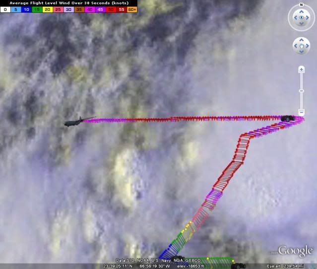
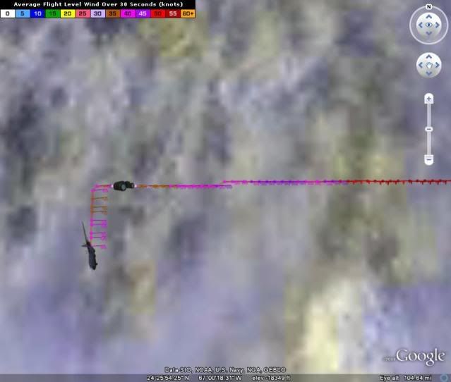
Hurakan's NHC report puts the center in the west yellow circle rotation.
If that is the forming center it is much further south and west-heading than the models show.
Which is why I think it is the 23.8-65 center.
If that is the forming center it is much further south and west-heading than the models show.
Which is why I think it is the 23.8-65 center.
0 likes

Re: ATL: Invest 92L
Is it possible for that upper level trof staying put throughout the whole season? Might the GOM get no canes at all this year or still a possibility of a home grown one? If it stays in place, is it due to el nino?
0 likes
-
cheezyWXguy

- Category 5
- Posts: 6282
- Joined: Mon Feb 13, 2006 12:29 am
- Location: Dallas, TX
Re: ATL: Invest 92L
Jevo wrote:cheezyWXguy wrote:We have quite a consensus that leads this up the east coast, and assuming the synoptic setup doesn't change dramatically in the next 2 days, the high pressure to the north of this system is not strong enough far enough west to keep this thing going straight west long enough to hit the gulf. Based on its "location" it would have to move directly west to get to the gulf at a latitude that would allow it to stay over water for a decent amount of time. However, its "movement" now is 315, or NW, meaning it probably won't get there.
Excuse my inexperience.... I noticed you used motion of 315/NW in quotes. How are we able to determine an initial motion w/o a defined center of circulation?
Thats why I put it, as well as location, in quotes. Neither of which can be determined at the time, but that is the information that was put into the SHIPS model
0 likes
-
x-y-no

- Category 5
- Posts: 8359
- Age: 65
- Joined: Wed Aug 11, 2004 12:14 pm
- Location: Fort Lauderdale, FL
Re: ATL : Invest 92L - Recon Thread
cycloneye wrote:Derek,no word yet from P3?
I saw a dropsonde earlier.
0 likes
-
storms NC

- Tropical Storm

- Posts: 247
- Age: 70
- Joined: Tue Sep 14, 2004 2:41 pm
- Location: Coast of NC & southwest coast of Fla
Re: ATL: Invest 92L
David in FL wrote:Is there any chance of this thing hitting us in NFL or is it to early to tell?
NFla is like Ga. It is like tucked in. By this it goes inland. But that does not mean you will never be hit by a storm. It would just have to be the right set up.
0 likes
-
cycloneye
- Admin
- Posts: 149400
- Age: 69
- Joined: Thu Oct 10, 2002 10:54 am
- Location: San Juan, Puerto Rico
Re: ATL : Invest 92L - Recon Thread
ENE winds.
URNT15 KNHC 252240
AF302 01AAA INVEST HDOB 24 20090825
223030 2427N 06732W 9768 00318 0132 +219 +171 080038 038 036 003 00
223100 2425N 06732W 9774 00313 0132 +219 +171 080039 040 037 001 00
223130 2424N 06732W 9768 00318 0132 +214 +170 081038 039 038 003 00
223200 2422N 06732W 9770 00315 0132 +216 +170 082038 039 037 002 00
223230 2420N 06732W 9765 00321 0132 +215 +169 082037 040 036 004 00
223300 2419N 06732W 9770 00316 0132 +210 +168 079037 038 036 004 00
223330 2417N 06732W 9762 00323 0132 +209 +166 077036 037 037 003 00
223400 2416N 06732W 9766 00318 0131 +212 +164 080036 037 035 005 03
223430 2414N 06732W 9769 00314 0131 +209 +162 083036 039 035 004 00
223500 2412N 06732W 9772 00312 0130 +205 +161 084041 042 037 005 00
223530 2411N 06732W 9769 00315 0131 +198 +159 080036 038 039 008 00
223600 2409N 06733W 9773 00311 0129 +207 +156 082041 042 039 006 00
223630 2408N 06733W 9772 00311 0129 +200 +153 079039 042 040 006 00
223700 2406N 06733W 9774 00307 0129 +184 +151 075044 046 047 018 00
223730 2404N 06733W 9769 00310 0128 +187 +148 074045 047 043 011 00
223800 2403N 06734W 9769 00311 0126 +203 +144 071038 040 038 007 00
223830 2401N 06734W 9770 00310 0125 +210 +143 072037 039 039 000 00
223900 2359N 06734W 9770 00309 0125 +210 +145 073037 040 042 000 00
223930 2358N 06735W 9771 00307 0125 +205 +148 072036 037 039 005 00
224000 2356N 06735W 9771 00306 0124 +202 +150 069039 041 043 003 00
$$
0 likes
Who is online
Users browsing this forum: No registered users and 176 guests