ATL: TROPICAL DEPRESSION DANNY (05L)

Moderator: S2k Moderators

Message
Author
User avatar
gatorcane
S2K Supporter
S2K Supporter
Posts: 23691
Age: 47
Joined: Sun Mar 13, 2005 3:54 pm
Location: Boca Raton, FL

#941 Postby gatorcane » Wed Aug 26, 2009 7:56 am

:uarrow: that is precisely the problem here.

You look at the models and they just are not correct this time (and have not been correct all week). The NHC keeps mentioning the Bahamas needs to closely monitor this system. Looking at those models above, why would the NHC even think to say that?

Throw the models out for the time being. Yes a curve to the north will happen but probably farther west closer or through the Bahamas.

As for the Carolinas, well with a system sitting to your south like this with weak ridgingin and a trough hanging out to the west, you bet you want to closely watch this one also.
Last edited by gatorcane on Wed Aug 26, 2009 7:58 am, edited 4 times in total.
0 likes   

User avatar
HURAKAN
Professional-Met
Professional-Met
Posts: 46086
Age: 38
Joined: Thu May 20, 2004 4:34 pm
Location: Key West, FL
Contact:

#942 Postby HURAKAN » Wed Aug 26, 2009 7:56 am

000
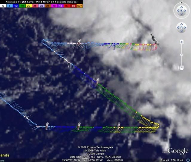
URNT15 KWBC 261247
NOAA3 WXWXA AL92 HDOB 28 20090826
123730 2430N 06857W 6434 03858 0107 +050 +034 237007 008 999 999 03
123800 2430N 06854W 6435 03856 0106 +050 +034 244008 008 003 000 03
123830 2430N 06852W 6434 03857 0104 +052 +031 245008 009 004 000 03
123900 2430N 06849W 6435 03855 0104 +050 +036 249010 010 007 000 03
123930 2430N 06847W 6436 03852 0104 +049 +041 243013 013 005 000 00
124000 2430N 06844W 6436 03851 0099 +052 +044 249012 013 007 000 03
124030 2430N 06842W 6432 03855 0089 +056 +053 254013 015 014 000 03
124100 2430N 06839W 6428 03861 0094 +053 +048 245016 017 034 006 03
124130 2430N 06837W 6417 03871 0079 +057 +054 216013 016 034 015 03
124200 2430N 06834W 6383 03912 0090 +046 +046 174013 023 044 024 03
124230 2430N 06832W 6435 03849 0100 +048 +046 243009 010 999 999 03
124300 2430N 06829W 6425 03864 0102 +048 +040 242010 011 999 999 03
124330 2430N 06827W 6428 03861 0098 +051 +048 245013 014 024 000 03
124400 2430N 06824W 6427 03862 0101 +049 +048 240015 015 999 999 03
124430 2430N 06822W 6427 03863 0097 +052 +051 228017 017 999 999 03
124500 2430N 06819W 6427 03865 0097 +053 +046 223018 020 999 999 03
124530 2430N 06817W 6428 03861 0097 +052 +047 217018 020 999 999 03
124600 2430N 06814W 6428 03860 0096 +051 +049 221020 022 999 999 03
124630 2430N 06812W 6426 03862 0101 +048 +048 217023 025 999 999 03
124700 2430N 06809W 6430 03860 0099 +049 +049 214030 032 999 999 03
0 likes   

User avatar
KWT
Category 5
Category 5
Posts: 31415
Joined: Tue Aug 17, 2004 11:02 am
Location: UK!!!

#943 Postby KWT » Wed Aug 26, 2009 7:57 am

Got to admit that is very exposed isn't it!

Recon will probably find a mid level circulation quite a lot to the ENE of that location it appears.
0 likes   

User avatar
srainhoutx
S2K Supporter
S2K Supporter
Posts: 6919
Age: 67
Joined: Sun Jan 14, 2007 11:34 am
Location: Haywood County, NC
Contact:

Re: ATL: Invest 92L - Computer Models

#944 Postby srainhoutx » Wed Aug 26, 2009 7:57 am

HPC thoughts this morning...snipet...

PRELIMINARY EXTENDED FORECAST DISCUSSION
NWS HYDROMETEOROLOGICAL PREDICTION CENTER CAMP SPRINGS MD
819 AM EDT WED AUG 26 2009

VALID 12Z SUN AUG 30 2009 - 12Z WED SEP 02 2009


EAST COAST/TROPICS...
TROPICAL SYSTEM NEAR 24N 69W CONTS TO INTENSIFY. GLOBAL MODELS
CONT TO HAVE A MORE WESTERLY TRACK WHILE IT INTERACTS WITH A
LINGERING MID LEVEL TROF OVER ERN CONUS LATE THURSDAY AND EARLY
FRIDAY ALLOWING IT TO LIFT RAPIDLY NWD WHILE HURRICANE MODEL
GUIDANCE CONTS TO CLUSTER WITH A MORE OFSHORE TRACK. ALL PHASE
DIAGRAM GUIDANCE INDICATES A MDT/DEEP SYMETRIC WARM CORE LOW
BECOMING BAROCLINIC ONCE IT REACHES HIGHER LATITUDES. HAVE RE
ADJUSTED DAY 3 SAT TOWARDS A DEEPER AND JUST OFF SHORE VA CAPES
SOLUTION FOR NOW WITH AN ATTEMPT TO SHOW THIS TRANSFORMING TOWARD
A BAROCLINIC LOW WITH A CMC/ECMWF BLEND SOLUTION. LATEST NAM RUNS
CONVERGING ON A DEEPER TREND CLOSER TO CMC. LATEST NHC/TPC
OUTLOOKS INDICATE THAT THIS SYSTEM WILL BE A TROPICAL STORM AND
NAMED TODAY. SEE NHC/TPC OUTLOOKS AND FUTURE ADVISORIES/WARNINGS.
CURRENT PRELIMS ARE TOTAL HPC DEPICTION. UPDATED AFTN HPC FINALS
WILL REFLECT CO ORDINATED NHC/HPC POSITIONS FOR DAYS 3 AND 4.
JAMES/ROSENSTEIN
0 likes   

User avatar
HURAKAN
Professional-Met
Professional-Met
Posts: 46086
Age: 38
Joined: Thu May 20, 2004 4:34 pm
Location: Key West, FL
Contact:

#945 Postby HURAKAN » Wed Aug 26, 2009 7:58 am

Image
0 likes   

User avatar
BensonTCwatcher
Category 5
Category 5
Posts: 1046
Joined: Sat Aug 28, 2004 10:11 pm
Location: Southport NC

#946 Postby BensonTCwatcher » Wed Aug 26, 2009 7:58 am

I agree that models probably are coming back west. since they did not/could not factor the ULL shearing the system and keeping it shallow.
0 likes   

canes04
Category 1
Category 1
Posts: 302
Joined: Sat May 22, 2004 5:41 pm
Location: Miami, FL

Re: ATL: Invest 92L

#947 Postby canes04 » Wed Aug 26, 2009 8:00 am

Danny making his move to FLA. The models busted on this one.
I'm sure once he organizes it should move NW, by that time it may be into FLA and up the coast.
0 likes   

User avatar
KWT
Category 5
Category 5
Posts: 31415
Joined: Tue Aug 17, 2004 11:02 am
Location: UK!!!

#948 Postby KWT » Wed Aug 26, 2009 8:04 am

Yeah, I'm going to watch the next 12hrs of motion very closely as most models start lifting this out somewhat already by that time. The LLC is certainly exposed and the shear should be pretty strong for the next 12-18hrs at least as the ULL and 92L keep fairly close by, should eventually get further apart once this system starts to gain more latitude.
0 likes   

User avatar
storms NC
Tropical Storm
Tropical Storm
Posts: 247
Age: 69
Joined: Tue Sep 14, 2004 2:41 pm
Location: Coast of NC & southwest coast of Fla

Re: ATL: Invest 92L

#949 Postby storms NC » Wed Aug 26, 2009 8:05 am

canes04 wrote:Danny making his move to FLA. The models busted on this one.
I'm sure once he organizes it should move NW, by that time it may be into FLA and up the coast.


JMO here but I think more of a floyd track. It would come close to fl EC then turn up to SC to Va that would be my guess.
But as I look at this loop it is moveing more to the west than North. Not much North right now. Have to wait on recon to see what they have to say.
0 likes   

User avatar
HURAKAN
Professional-Met
Professional-Met
Posts: 46086
Age: 38
Joined: Thu May 20, 2004 4:34 pm
Location: Key West, FL
Contact:

Re: ATL: Invest 92L

#950 Postby HURAKAN » Wed Aug 26, 2009 8:06 am

Code: Select all

  *   ATLANTIC SHIPS INTENSITY FORECAST       *
                    *      GOES DATA AVAILABLE                  *
                    *      OHC  DATA AVAILABLE                  *
                    *  INVEST      AL922009  08/26/09  12 UTC   *

TIME (HR)          0     6    12    18    24    36    48    60    72    84    96   108   120
SHEAR (KT)         9     4     4     6     9     1     6    17    22    25    24    31    44
SHEAR DIR        328   354    29   337    19   353   194   202   223   219   217   214   236
SST (C)         28.9  28.9  29.0  29.0  29.0  29.1  29.1  28.9  28.7  28.3  28.2  26.8  23.9


Shear doesn't seem to be that light at the moment
0 likes   

Aric Dunn
Category 5
Category 5
Posts: 21238
Age: 42
Joined: Sun Sep 19, 2004 9:58 pm
Location: Ready for the Chase.
Contact:

#951 Postby Aric Dunn » Wed Aug 26, 2009 8:06 am

well im in between classes right now... and see we are all having fun.. Florida impact is increasingly becoming probably...
0 likes   

User avatar
KWT
Category 5
Category 5
Posts: 31415
Joined: Tue Aug 17, 2004 11:02 am
Location: UK!!!

#952 Postby KWT » Wed Aug 26, 2009 8:07 am

Yeah true Gatorcane, also note most of the dynamic models have this already moving at NW, when its probably moving around WNW and with an exposed LLC its not going to be strengthening much so in this set-up I can only see the models having to trend westwards.
0 likes   

User avatar
KWT
Category 5
Category 5
Posts: 31415
Joined: Tue Aug 17, 2004 11:02 am
Location: UK!!!

#953 Postby KWT » Wed Aug 26, 2009 8:09 am

Agreed Aric though I think this will still curve up before it reaches Florida and head up towards the Carolinas.

Also Hurakan, no chance the shear is that light right now, just goes to show that the models have a truely awful grasp on the ULL presently.
0 likes   

User avatar
HURAKAN
Professional-Met
Professional-Met
Posts: 46086
Age: 38
Joined: Thu May 20, 2004 4:34 pm
Location: Key West, FL
Contact:

#954 Postby HURAKAN » Wed Aug 26, 2009 8:10 am

URNT15 KWBC 261257
NOAA3 WXWXA AL92 HDOB 29 20090826
124730 2430N 06807W 6417 03875 0094 +051 +051 200027 033 999 999 03
124800 2430N 06804W 6431 03859 0094 +055 +039 193018 019 999 999 03
124830 2430N 06802W 6432 03856 0102 +051 +032 200019 019 999 999 03
124900 2429N 06759W 6432 03858 0099 +052 +040 193020 023 999 999 03
124930 2429N 06757W 6433 03857 0103 +051 +034 194021 022 999 999 03
125000 2429N 06755W 6432 03859 0109 +048 +035 189022 023 010 000 03
125030 2429N 06752W 6433 03857 0108 +047 +045 191025 026 999 999 03
125100 2429N 06750W 6432 03858 0110 +046 +037 192025 025 999 999 03
125130 2429N 06747W 6433 03857 0111 +046 +044 190024 025 999 999 03
125200 2429N 06745W 6432 03857 0105 +049 +049 194025 027 999 999 03
125230 2429N 06742W 6432 03861 0103 +051 +048 193025 028 999 999 03
125300 2429N 06740W 6430 03862 0104 +052 +035 186021 022 999 999 03
125330 2429N 06738W 6434 03859 0110 +049 +035 189024 025 999 999 03
125400 2429N 06735W 6431 03864 0112 +049 +036 184023 023 999 999 03
125430 2429N 06733W 6433 03862 0109 +050 +048 185026 028 999 999 03
125500 2429N 06730W 6433 03863 0111 +048 +047 178028 031 048 008 03
125530 2430N 06728W 6437 03856 0110 +048 +046 169027 029 999 999 03
125600 2431N 06726W 6437 03856 0113 +048 +034 176027 029 999 999 03
125630 2433N 06725W 6440 03853 0119 +045 +038 177026 029 999 999 03
125700 2435N 06726W 6441 03852 0119 +045 +042 173023 023 999 999 03
0 likes   

User avatar
AdamFirst
S2K Supporter
S2K Supporter
Posts: 2491
Age: 36
Joined: Thu Aug 14, 2008 10:54 am
Location: Port Saint Lucie, FL

#955 Postby AdamFirst » Wed Aug 26, 2009 8:10 am

So, pro mets and speculators alike, the chances they name this thing Danny at the 11 AM advisory?

50%+?
0 likes   

Aric Dunn
Category 5
Category 5
Posts: 21238
Age: 42
Joined: Sun Sep 19, 2004 9:58 pm
Location: Ready for the Chase.
Contact:

Re:

#956 Postby Aric Dunn » Wed Aug 26, 2009 8:11 am

KWT wrote:Agreed Aric though I think this will still curve up before it reaches Florida and head up towards the Carolinas.

Also Hurakan, no chance the shear is that light right now, just goes to show that the models have a truely awful grasp on the ULL presently.


well it was already going to be close according the Euro and cmc ( both within about 100 to 150 miles )

now that its faster and still moving west.. would not be surprised to see both having florida landfall at 12z run.

but will see .. the trough that is suppsed to pick it up is consistently being slower and slower.
0 likes   

User avatar
HURAKAN
Professional-Met
Professional-Met
Posts: 46086
Age: 38
Joined: Thu May 20, 2004 4:34 pm
Location: Key West, FL
Contact:

#957 Postby HURAKAN » Wed Aug 26, 2009 8:11 am

Image
0 likes   

curtadams
S2K Supporter
S2K Supporter
Posts: 1122
Joined: Sun Aug 28, 2005 7:57 pm
Location: Orange, California
Contact:

#958 Postby curtadams » Wed Aug 26, 2009 8:12 am

I don't see much shear around the LLC. Convection isn't being blown away. Convection is moderate near the center, but I suspect that's because the LLC formed from the old UL and so there's a lot of dry air.

Edit: I'm surprised it's not already named. Pretty obviously a storm with visibles (large circ, convection near center, low clouds moving east.)
Last edited by curtadams on Wed Aug 26, 2009 8:15 am, edited 1 time in total.
0 likes   

otowntiger
Category 5
Category 5
Posts: 1921
Joined: Tue Aug 31, 2004 7:06 pm

Re: ATL: Invest 92L

#959 Postby otowntiger » Wed Aug 26, 2009 8:14 am

canes04 wrote:Danny making his move to FLA. The models busted on this one.
I'm sure once he organizes it should move NW, by that time it may be into FLA and up the coast.
I don't think this storm is anywhere close to a Florida threat. First, none of the models are bringing it close to Florida, and for that matter none that I see are even having it hit NC, although much closer there. Second this thing is so one sided that even if the center came right up to the coast, all the weather would be way off shore (although I know that could change with intensification). But regardless of that it appears to my untrained eye that the synoptics just aren't there for any real FL threat.
Last edited by otowntiger on Wed Aug 26, 2009 8:24 am, edited 1 time in total.
0 likes   

User avatar
HURAKAN
Professional-Met
Professional-Met
Posts: 46086
Age: 38
Joined: Thu May 20, 2004 4:34 pm
Location: Key West, FL
Contact:

#960 Postby HURAKAN » Wed Aug 26, 2009 8:17 am

URNT15 KWBC 261307
NOAA3 WXWXA AL92 HDOB 30 20090826
125730 2437N 06728W 6440 03852 0116 +045 +044 164025 027 999 999 03
125800 2438N 06729W 6424 03874 0117 +041 +041 172028 033 042 022 03
125830 2440N 06731W 6429 03864 0110 +045 +045 169029 036 049 022 00
125900 2442N 06733W 6419 03880 0112 +045 +045 169021 026 042 005 03
125930 2444N 06735W 6429 03864 0110 +048 +044 179021 024 039 001 03
130000 2445N 06736W 6432 03862 0110 +050 +039 174025 027 999 999 03
130030 2447N 06737W 6438 03855 0098 +057 +033 166025 026 999 999 03
130100 2450N 06739W 6436 03856 0100 +053 +048 162021 022 999 999 03
130130 2452N 06740W 6429 03861 0102 +048 +048 161020 022 999 999 03
130200 2454N 06741W 6409 03882 0094 +049 +049 159024 029 050 019 03
130230 2456N 06742W 6381 03926 0098 +049 +049 170023 027 046 026 03
130300 2458N 06743W 6401 03898 0100 +049 +049 169023 024 999 999 03
130330 2500N 06744W 6404 03893 0091 +053 +053 173023 024 047 017 03
130400 2503N 06745W 6448 03840 0097 +055 +051 183026 028 999 999 03
130430 2505N 06746W 6444 03845 0098 +056 +050 175028 029 999 999 03
130500 2506N 06748W 6450 03838 0102 +054 +050 169026 028 035 001 03
130530 2508N 06749W 6437 03858 0102 +053 +049 165024 025 999 999 03
130600 2510N 06750W 6426 03869 0102 +053 +040 166024 025 999 999 03
130630 2513N 06752W 6433 03860 0105 +052 +045 170026 028 999 999 03
130700 2515N 06753W 6435 03857 0104 +052 +048 176019 020 999 999 03

I have to leave for half an hour. Someone, please, take over
0 likes   


Return to “2009”

Who is online

Users browsing this forum: No registered users and 5 guests