ATL: TROPICAL DEPRESSION DANNY (05L)
Moderator: S2k Moderators
-
SEASON_CANCELED

- Category 3

- Posts: 887
- Joined: Mon Jul 06, 2009 5:17 am
- Location: 8 Bit Charlie Sheen
Re: ATL: TROPICAL STORM DANNY - Computer Models
Whats going on. This thing is heading way west. That naked swirl is the system. Not the convection
0 likes

-
Derek Ortt
WOCN31 CWHX 271800
Tropical storm Danny information statement issued by the
Canadian hurricane centre of Environment Canada at 3.00 PM ADT
Thursday 27 August 2009.
The next statement will be issued by 9.00 PM ADT
... Danny still taking shape ...
1. Current position, strength, central pressure and motion
At 3.00 PM ADT... Tropical storm Danny was located near latitude
27.4 N and longitude 73.5 W... About 400 nautical miles or 740 km
east northeast of Miami . Maximum sustained winds are
Estimated at 50 knots... 93 km/h... And central pressure at 1004
MB. Danny is moving west northwest at 8 knots... 15 km/h.
2. Forecast position, central pressure and strength
Date time lat lon MSLP Max wind
ADT MB kts kmh
Aug 27 3.00 PM 27.4N 73.5W 1004 50 93
Aug 28 3.00 AM 29.4N 74.3W 1003 55 102
Aug 28 3.00 PM 31.8N 74.6W 998 60 111
Aug 29 3.00 AM 35.3N 73.3W 982 65 120
Aug 29 3.00 PM 39.7N 70.2W 982 65 120
Aug 30 3.00 AM 43.5N 66.3W 986 60 111 transitioning
Aug 30 3.00 PM 47.2N 61.1W 994 55 102 post-tropical
Aug 31 3.00 AM 49.7N 54.7W 992 45 83 post-tropical
Aug 31 3.00 PM 51.5N 47.1W 998 40 74 post-tropical
Sep 01 3.00 AM 52.8N 39.5W 1000 35 65 post-tropical
Sep 01 3.00 PM 54.2N 30.5W 1002 30 56 post-tropical
3. Public weather impacts and warnings summary
Eventually Danny will produce rain over the late weekend
But it is too early to determine amounts.
4. Marine weather impacts and warnings summary
Danny will weaken as it moves through canadian waters
Though it may produce hurricane winds upon first entering
The marine district.. The winds will diminish as it
Continues to move over colder waters.
5. Technical discussion for meteorologists
A. Analysis
Visual satellite imagery shows a low level circulation centre
That is removed to the west of the convection. As a result..
Danny is reanalysed further west than previously noted.
B. Prognostic
Despite being removed from the area of convection.. Danny
Looks more more organised on the satellite imagery.
The model guidance continues to show Danny developing
Into a marginal hurricane as it tracks northward
And passes the Carolina coast. Such a track is based on the
System coming under southerly winds ahead of an upper
Low near the Mississippi delta. Thereafter Danny
Comes under the influence of the westerlies over Canada.
Phase space diagrams indicate Danny will begin extra
Tropical transition once it passes Cape Cod and become post
Tropical as it moves through the Maritimes and Newfoundland.
It must be emphasized that there is still a lot of uncertainty
With respect to the track and intensity of Danny once it
Reaches canadian waters. We are in agreement with the guidance
From Miami so far.
C. Public weather
Decaying tropical systems often produce heavy rain over the
Martimes and past experience indicates that locally higher
Amounts may be produced. Dynamic models are producing the
Expected qpfs but with the maximums in various locations
As can be expected with decaying tropical systems .
D. Marine weather
Wind radii initialised on this mornings quickscat overpass
And modelled thereafter.
Predicted wind radii (NM)
Time gales storms hurricane
Ne se sw nw ne se sw nw ne se sw nw
27/18Z 200 200 0 200 120 0 0 0 0 0 0 0
28/06Z 200 200 0 200 120 0 0 0 0 0 0 0
28/18Z 200 200 30 180 100 30 0 30 0 0 0 0
29/06Z 200 200 75 100 90 75 30 45 0 20 0 0
29/18Z 200 200 75 100 90 90 45 45 0 20 0 0
30/06Z 200 200 75 100 90 90 45 30 0 0 0 0
30/18Z 200 200 90 100 90 90 45 0 0 0 0 0
31/06Z 200 200 90 90 0 0 0 0 0 0 0 0
31/18Z 200 200 90 90 0 0 0 0 0 0 0 0
01/06Z 200 200 90 90 0 0 0 0 0 0 0 0
01/18Z 200 200 90 90 0 0 0 0 0 0 0 0
End campbell
0 likes
-
vacanechaser

- Category 5

- Posts: 1461
- Joined: Wed Dec 03, 2003 9:34 pm
- Location: Portsmouth, Va
- Contact:
Re: ATL: TROPICAL STORM DANNY
AtlanticWind wrote:wxman57 wrote:Ignore that little swirl that WAS the center, it's weakening as it moves off to the west. Focus your attention on the convection to the east. That's Danny. The convection isn't moving much now. Wind shear is just too strong. But the convection will generate inflow into this region eventually, if it persists. Look for a new center to develop closer to (or under) the convection tonight, assuming the wind shear drops. And that upper trof approaches from the west tomorrow, driving the whole sheared mess northward as per most model guidance.
I think that little swirl IS Danny and if that winds down then write off this system.(which may be the most likely outcome)
i would agree... that circulation is to strong the "was the center" to be not the center any longer... sorry, but we have seen many systems like this in the past, and as long as the center is this strong, it maintains and is the main system... until that happens, it weakens, which i see no evidence of that happening, this will be the main center... nothing further north and east imo right now...
Jesse V. Bass III
http://www.vastormphoto.com
Hurricane Intercept Research Team
0 likes
-
HURAKAN

- Professional-Met

- Posts: 46084
- Age: 39
- Joined: Thu May 20, 2004 4:34 pm
- Location: Key West, FL
- Contact:
648
URNT15 KNHC 271903
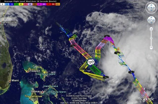
AF307 0505A DANNY HDOB 37 20090827
185400 2929N 07525W 4073 07472 0422 -142 +999 343013 014 010 004 05
185430 2931N 07527W 3993 07628 0432 -147 +999 322010 012 008 003 05
185500 2932N 07528W 3920 07769 0442 -151 +999 305009 009 014 003 01
185530 2934N 07529W 3849 07905 0452 -161 +999 300007 007 012 003 01
185600 2936N 07531W 3770 08063 0463 -175 +999 300006 007 007 004 01
185630 2937N 07532W 3700 08225 0487 -185 +999 293006 007 006 004 01
185700 2939N 07533W 3619 08387 0504 -198 +999 295010 011 009 004 01
185730 2941N 07535W 3535 08560 0515 -210 +999 302015 015 011 004 01
185800 2942N 07536W 3473 08667 0499 -221 +999 299014 015 021 001 01
185830 2944N 07537W 3423 08781 0505 -229 +999 293011 012 024 000 01
185900 2945N 07539W 3386 08858 0511 -232 -300 288007 008 022 001 00
185930 2947N 07540W 3337 08967 0518 -242 -300 305006 007 022 002 00
190000 2949N 07542W 3330 08980 0518 -247 -300 318005 006 023 002 00
190030 2951N 07543W 3295 09049 0523 -251 -300 323006 006 025 001 00
190100 2953N 07545W 3290 09065 0522 -255 -300 325006 006 023 002 00
190130 2954N 07546W 3291 09056 0522 -255 -300 322006 006 025 001 00
190200 2956N 07548W 3291 09057 0522 -255 -300 312006 006 020 002 00
190230 2958N 07550W 3291 09063 0523 -255 -300 315005 006 020 002 00
190300 3001N 07551W 3294 09056 0524 -255 -300 309005 005 020 001 00
190330 3003N 07553W 3291 09063 0526 -255 -300 313005 005 020 001 00
$$
;
Plane leaving
URNT15 KNHC 271903
AF307 0505A DANNY HDOB 37 20090827
185400 2929N 07525W 4073 07472 0422 -142 +999 343013 014 010 004 05
185430 2931N 07527W 3993 07628 0432 -147 +999 322010 012 008 003 05
185500 2932N 07528W 3920 07769 0442 -151 +999 305009 009 014 003 01
185530 2934N 07529W 3849 07905 0452 -161 +999 300007 007 012 003 01
185600 2936N 07531W 3770 08063 0463 -175 +999 300006 007 007 004 01
185630 2937N 07532W 3700 08225 0487 -185 +999 293006 007 006 004 01
185700 2939N 07533W 3619 08387 0504 -198 +999 295010 011 009 004 01
185730 2941N 07535W 3535 08560 0515 -210 +999 302015 015 011 004 01
185800 2942N 07536W 3473 08667 0499 -221 +999 299014 015 021 001 01
185830 2944N 07537W 3423 08781 0505 -229 +999 293011 012 024 000 01
185900 2945N 07539W 3386 08858 0511 -232 -300 288007 008 022 001 00
185930 2947N 07540W 3337 08967 0518 -242 -300 305006 007 022 002 00
190000 2949N 07542W 3330 08980 0518 -247 -300 318005 006 023 002 00
190030 2951N 07543W 3295 09049 0523 -251 -300 323006 006 025 001 00
190100 2953N 07545W 3290 09065 0522 -255 -300 325006 006 023 002 00
190130 2954N 07546W 3291 09056 0522 -255 -300 322006 006 025 001 00
190200 2956N 07548W 3291 09057 0522 -255 -300 312006 006 020 002 00
190230 2958N 07550W 3291 09063 0523 -255 -300 315005 006 020 002 00
190300 3001N 07551W 3294 09056 0524 -255 -300 309005 005 020 001 00
190330 3003N 07553W 3291 09063 0526 -255 -300 313005 005 020 001 00
$$
;
Plane leaving
0 likes
-
carolina_73

- Tropical Storm

- Posts: 148
- Joined: Wed Jul 23, 2008 1:30 am
Re: ATL: TROPICAL STORM DANNY - Computer Models
SEASON_CANCELED wrote:Whats going on. This thing is heading way west. That naked swirl is the system. Not the convection
Yeah it is. Pretty soon it will be right offshore of Florida. I can see why the latest GFS and GFDL takes it further W. The LLC is clearly moving DUE W and the convection is slowly following it as well. Alot of peeps seem to think it's moving to the N and NW. That is the clouds being sheared in that direction.
0 likes

-
storms NC

- Tropical Storm
- Posts: 247
- Age: 70
- Joined: Tue Sep 14, 2004 2:41 pm
- Location: Coast of NC & southwest coast of Fla
Re: ATL: TROPICAL STORM DANNY
vacanechaser wrote:AtlanticWind wrote:wxman57 wrote:Ignore that little swirl that WAS the center, it's weakening as it moves off to the west. Focus your attention on the convection to the east. That's Danny. The convection isn't moving much now. Wind shear is just too strong. But the convection will generate inflow into this region eventually, if it persists. Look for a new center to develop closer to (or under) the convection tonight, assuming the wind shear drops. And that upper trof approaches from the west tomorrow, driving the whole sheared mess northward as per most model guidance.
I think that little swirl IS Danny and if that winds down then write off this system.(which may be the most likely outcome)
First person that make sence.Thanks
i would agree... that circulation is to strong the "was the center" to be not the center any longer... sorry, but we have seen many systems like this in the past, and as long as the center is this strong, it maintains and is the main system... until that happens, it weakens, which i see no evidence of that happening, this will be the main center... nothing further north and east imo right now...
Jesse V. Bass III
http://www.vastormphoto.com
Hurricane Intercept Research Team
0 likes
-
vbhoutex

- Storm2k Executive

- Posts: 29147
- Age: 74
- Joined: Wed Oct 09, 2002 11:31 pm
- Location: Cypress, TX
- Contact:
Re: ATL: TROPICAL STORM DANNY
Just my amateur opinion, but what I see on the visible is convection becoming linear and the naked llcc beginning to elongate sw-ne or ssw-nne. Danny, at a minimum, is a conundrum!! Glad I don't have to forecast him!!!
0 likes
-
tolakram
- Admin
- Posts: 20185
- Age: 62
- Joined: Sun Aug 27, 2006 8:23 pm
- Location: Florence, KY (name is Mark)
Re: ATL: TROPICAL STORM DANNY - Computer Models
SEASON_CANCELED wrote:Whats going on. This thing is heading way west. That naked swirl is the system. Not the convection
Well I certainly hope you don't get hit with a naked swirl, sounds deadly. If Danny is a tropical storm then the LLC will have to stay near the convection or it will die.
0 likes
-
AdamFirst

- S2K Supporter

- Posts: 2490
- Age: 36
- Joined: Thu Aug 14, 2008 10:54 am
- Location: Port Saint Lucie, FL
Re: ATL: TROPICAL STORM DANNY
Looks like some low clouds are beginning to gather around the LLC. Could this be a sign that it's ready to make a move?
0 likes
-
wxman57

- Moderator-Pro Met

- Posts: 23174
- Age: 68
- Joined: Sat Jun 21, 2003 8:06 pm
- Location: Houston, TX (southwest)
Re: ATL: TROPICAL STORM DANNY
vbhoutex wrote:Just my amateur opinion, but what I see on the visible is convection becoming linear and the naked llcc beginning to elongate sw-ne or ssw-nne. Danny, at a minimum, is a conundrum!! Glad I don't have to forecast him!!!
If you step back and take a look at a loop, I think I can see a mid-level rotation beginning beneath the convection (23N/71W). With nothing to sustain that little vortex that rotated westward away from the convection, that mid-level rotation will probably extend down to the surface tonight and we'll have a newly-formed center. This should keep the system far enough east of the Carolinas that they won't get much out of it. And it'll probably pass east of Cape Cod, so maybe not much impact there, either. Really depends on its structure/tropical characteristics as it passes Cape Cod, though.
I hate sheared storms.
Oh, and it is still not going to Florida.
0 likes
-
AtlanticWind

- S2K Supporter
- Posts: 1898
- Age: 67
- Joined: Sun Aug 08, 2004 9:57 pm
- Location: Plantation,Fla
Re: ATL: TROPICAL STORM DANNY
wxman57 wrote:vbhoutex wrote:Just my amateur opinion, but what I see on the visible is convection becoming linear and the naked llcc beginning to elongate sw-ne or ssw-nne. Danny, at a minimum, is a conundrum!! Glad I don't have to forecast him!!!
If you step back and take a look at a loop, I think I can see a mid-level rotation beginning beneath the convection (23N/71W). With nothing to sustain that little vortex that rotated westward away from the convection, that mid-level rotation will probably extend down to the surface tonight and we'll have a newly-formed center. This should keep the system far enough east of the Carolinas that they won't get much out of it. And it'll probably pass east of Cape Cod, so maybe not much impact there, either. Really depends on its structure/tropical characteristics as it passes Cape Cod, though.
I hate sheared stor
Oh, and it is still not going to Florida.
How about Texas?
0 likes
-
storms NC
- Tropical Storm
- Posts: 247
- Age: 70
- Joined: Tue Sep 14, 2004 2:41 pm
- Location: Coast of NC & southwest coast of Fla
The convection to the east of the LLC is about to move over it. you can see in this VLoop
http://www.ssd.noaa.gov/goes/flt/t1/loop-vis.html
http://www.ssd.noaa.gov/goes/flt/t1/loop-vis.html
0 likes
-
srainhoutx

- S2K Supporter
- Posts: 6919
- Age: 68
- Joined: Sun Jan 14, 2007 11:34 am
- Location: Haywood County, NC
- Contact:
Re: ATL: TROPICAL STORM DANNY
wxman57 wrote:vbhoutex wrote:Just my amateur opinion, but what I see on the visible is convection becoming linear and the naked llcc beginning to elongate sw-ne or ssw-nne. Danny, at a minimum, is a conundrum!! Glad I don't have to forecast him!!!
If you step back and take a look at a loop, I think I can see a mid-level rotation beginning beneath the convection (23N/71W). With nothing to sustain that little vortex that rotated westward away from the convection, that mid-level rotation will probably extend down to the surface tonight and we'll have a newly-formed center. This should keep the system far enough east of the Carolinas that they won't get much out of it. And it'll probably pass east of Cape Cod, so maybe not much impact there, either. Really depends on its structure/tropical characteristics as it passes Cape Cod, though.
I hate sheared storms.
Oh, and it is still not going to Florida.
Thanks for the update wxman57
Last edited by srainhoutx on Thu Aug 27, 2009 2:38 pm, edited 1 time in total.
0 likes
-
curtadams
- S2K Supporter
- Posts: 1122
- Joined: Sun Aug 28, 2005 7:57 pm
- Location: Orange, California
- Contact:
The LLC is Danny at the low level and the convection (actually the swirling part) is Danny at upper levels. They are still connected. When they disconnect, it will look like something broke and the two pieces will fly apart. You see that all the time with sheared storms - the MLC will hang around at a roughly fixed distance from the LLC and then abruptly fly off.
If the MLC manages to generate a new LL vortex while still connected the vortex will spin off and merge with the LLC. Alberto was a good example of that.
If the MLC manages to generate a new LL vortex while still connected the vortex will spin off and merge with the LLC. Alberto was a good example of that.
0 likes
-
storms NC
- Tropical Storm
- Posts: 247
- Age: 70
- Joined: Tue Sep 14, 2004 2:41 pm
- Location: Coast of NC & southwest coast of Fla
Re: ATL: TROPICAL STORM DANNY
AtlanticWind wrote:wxman57 wrote:vbhoutex wrote:Just my amateur opinion, but what I see on the visible is convection becoming linear and the naked llcc beginning to elongate sw-ne or ssw-nne. Danny, at a minimum, is a conundrum!! Glad I don't have to forecast him!!!
If you step back and take a look at a loop, I think I can see a mid-level rotation beginning beneath the convection (23N/71W). With nothing to sustain that little vortex that rotated westward away from the convection, that mid-level rotation will probably extend down to the surface tonight and we'll have a newly-formed center. This should keep the system far enough east of the Carolinas that they won't get much out of it. And it'll probably pass east of Cape Cod, so maybe not much impact there, either. Really depends on its structure/tropical characteristics as it passes Cape Cod, though.
I hate sheared stor
Oh, and it is still not going to Florida.
How about Texas?
You should start Still not going to NC or the EC
0 likes
-
AtlanticWind
- S2K Supporter
- Posts: 1898
- Age: 67
- Joined: Sun Aug 08, 2004 9:57 pm
- Location: Plantation,Fla
Re:
storms NC wrote:The convection to the east of the LLC is about to move over it. you can see in this VLoop
http://www.ssd.noaa.gov/goes/flt/t1/loop-vis.html
I think if Danny survives it will be the LLC we are following and the threat to the Northest will be greater (for a tropical storm or Cat 1)
0 likes
Who is online
Users browsing this forum: No registered users and 16 guests