
ATL : TROPICAL DEPRESSION ERIKA (06L)
Moderator: S2k Moderators
Re: ATL : INVEST 94L - Computer Models
its way too early in the game folks. I see this tracking further west over time. This is not Bill by any means.
0 likes

Bocadude85, very true though that is rather dependant on the system being at 55W at 168hrs.
We shall see, I'm in no ways saying it will go into the weakness, esp if it can stay further south then some of the models are currently progging.
Also as with Bill it doesn't seem to have a very good fix on this systems intial starting point, but thats not here or there really.
Steve, yep and I'm having a tough time seeing it gain as much latitude as some models are progging, esp if this stays in its current state. Going to be an interesting few days, esp if that shear does lower.
0 likes
-
Emmett_Brown

- Category 5

- Posts: 1433
- Joined: Wed Aug 24, 2005 9:10 pm
- Location: Sarasota FL
Re: ATL : INVEST 94L
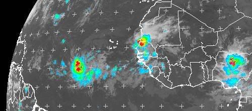
The easterly shear looks strong, but according to Quickscat, there is no well defined surface center yet, just an East/West elongated trough. This means that a surface center could pop up anywhere... IMO, if the current trend continues, look for a center to pop up further west where the deep convection is.

0 likes
Yeah thats quite a big possiblity actually Emmett, and clearly if it does then that will have to shunt the forecast further west again. I suspect we will see a MLC try to devleop in the convection somewhere if it hasn't already and that may be enough to tease a LLC to develop in that region.
For now the longer it stays the weak it appears the further west it goes in the long term it seems.
For now the longer it stays the weak it appears the further west it goes in the long term it seems.
0 likes
-
jlauderdal
- S2K Supporter

- Posts: 7240
- Joined: Wed May 19, 2004 5:46 am
- Location: NE Fort Lauderdale
- Contact:

-
HurricaneBelle

- S2K Supporter
- Posts: 1209
- Joined: Sun Aug 27, 2006 6:12 pm
- Location: Clearwater, FL
Re: ATL : INVEST 94L
jlauderdal wrote:these guys are on watch
And this guy is ready to order the Code Red:

0 likes
-
jlauderdal
- S2K Supporter
- Posts: 7240
- Joined: Wed May 19, 2004 5:46 am
- Location: NE Fort Lauderdale
- Contact:
Re: ATL : INVEST 94L
HurricaneBelle wrote:jlauderdal wrote:these guys are on watch
And this guy is ready to order the Code Red:
the bears are definitively a little less concerned about the system at this time, i have some more bears ready to go should the situation become more dire in the days ahead
0 likes


-
Blown Away

- S2K Supporter
- Posts: 10253
- Joined: Wed May 26, 2004 6:17 am
Re: ATL : INVEST 94L
Seems the weakness Danny leaves behind will linger for about 7 days then the high pressure starts to fill in starting after day 7. I calculate at @12mph it would take 94L @10 days to make it near the CONUS. If 94L maintains a general WNW track it will be between 60-70W in 6 days, which may be the time Danny's weakness begins to fill in. IMO, I think our NE Caribbean friends will be sweating over 94L. 
0 likes
-
expat2carib

- S2K Supporter
- Posts: 458
- Joined: Tue Jul 22, 2008 1:44 pm
- Location: Sint Maarten

-
jlauderdal
- S2K Supporter
- Posts: 7240
- Joined: Wed May 19, 2004 5:46 am
- Location: NE Fort Lauderdale
- Contact:
Re: ATL : INVEST 94L
expat2carib wrote:Boring up till now. Gaaaaaapp
that guy is upset about all these recurves
0 likes
-
Blown Away
- S2K Supporter
- Posts: 10253
- Joined: Wed May 26, 2004 6:17 am
Re: ATL : INVEST 94L
jlauderdal wrote:expat2carib wrote:Boring up till now. Gaaaaaapp
that guy is upset about all these recurves
Jlauderdal you have a replacement for your avatar!!!!
0 likes
-
expat2carib
- S2K Supporter
- Posts: 458
- Joined: Tue Jul 22, 2008 1:44 pm
- Location: Sint Maarten
Re: ATL : INVEST 94L
jlauderdal wrote:expat2carib wrote:Boring up till now. Gaaaaaapp
that guy is upset about all these recurves
Yes...yes... They promise you a storm and in the end you end up hungry......
I hope, it's not going to develop.
0 likes


Re: ATL : INVEST 94L - Computer Models
Ivanhater wrote:GFS Ensembles
2 camps right now and shows the uncertainy of the evolution of the 94L and if the weakness will be filling.....
I am thinking recurve but my gut is telling me a low lat tracker that takes some time to develope. JMO....
0 likes
-
Bocadude85

- Category 5
- Posts: 2991
- Age: 39
- Joined: Mon Apr 18, 2005 2:20 pm
- Location: Honolulu,Hi
Re: ATL : INVEST 94L - Computer Models
Ivanhater wrote:GFS Ensembles
Seems most of those show a bend to the west at the end.
0 likes
-
Stormcenter
- S2K Supporter
- Posts: 6689
- Joined: Wed Sep 03, 2003 11:27 am
- Location: Houston, TX
Re: ATL : INVEST 94L - Computer Models
Well I believe the consensus seems to point toward a more wnw track and eventual curve.
I know some of you folks want some close to home action but I just see this with
94L right now.
http://www.wunderground.com/tropical/tr ... model.html
I know some of you folks want some close to home action but I just see this with
94L right now.
http://www.wunderground.com/tropical/tr ... model.html
Bocadude85 wrote:Ivanhater wrote:GFS Ensembles
Seems most of those show a bend to the west at the end.
0 likes
-
cycloneye

- Admin

- Posts: 149730
- Age: 69
- Joined: Thu Oct 10, 2002 10:54 am
- Location: San Juan, Puerto Rico
Re: ATL : INVEST 94L
Will focus on 94L tomorrow.
Yes 57,start to look at this system closely.
0 likes
Who is online
Users browsing this forum: No registered users and 81 guests