ATL : TROPICAL DEPRESSION ERIKA (06L)

Moderator: S2k Moderators

Message
Author
jinftl
Category 5
Category 5
Posts: 4312
Joined: Tue Aug 31, 2004 4:47 pm
Location: fort lauderdale, fl

Re: ATL : INVEST 94L - Computer Models

#681 Postby jinftl » Sat Aug 29, 2009 6:58 pm

Why are you reading and expending the energy to comment on how there is no need to comment? I may be mistaken, but this is a discussion forum for the tropics, right? Some folks are interested....and some are not. Is it ok if those who want to talk about 94L talk about it? No one is hyping this system, making more out of it, pressing the panic button, etc. IS that what makes the discussion such a waste? And dismissing this system...like any system... is very short-sighted.....there is potential (and some model support) for development down the road...but if you think the thread should be locked, I guess you can contact the admins.

Unclear why folks would spend so much time in a thread they deem a waste of energy?

:roll: :roll: :roll:

StormClouds63 wrote:
Stormcenter wrote:Way too much energy is being spent on 94. :)


Ditto!
0 likes   

jinftl
Category 5
Category 5
Posts: 4312
Joined: Tue Aug 31, 2004 4:47 pm
Location: fort lauderdale, fl

Re: ATL : INVEST 94L - Computer Models

#682 Postby jinftl » Sat Aug 29, 2009 7:01 pm

What is interesting is that the 6 hour forecast pegs this system moving NNW, while the motion today has been west (or even wsw....but that could be the center re-org all over the place)

Actual coordinates for today:

12 GMT 08/29/09 11.1N 41.2W 25 1010 Invest
18 GMT 08/29/09 10.6N 42.0W 25 1010 Invest

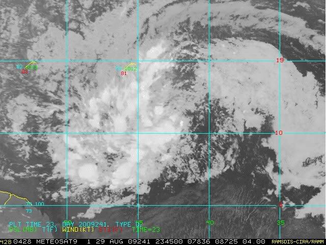
Ivanhater wrote:Hmm gains more than 1 degree latitude moving 339 degrees in 6 hours? Lol

0 11.0 42.0 270./14.0
6 12.2 42.5 339./13.6
0 likes   

User avatar
cycloneye
Admin
Admin
Posts: 145351
Age: 68
Joined: Thu Oct 10, 2002 10:54 am
Location: San Juan, Puerto Rico

Re: ATL : INVEST 94L

#683 Postby cycloneye » Sat Aug 29, 2009 7:06 pm

8 PM EDT discussion.

TROPICAL WEATHER DISCUSSION
NWS TPC/NATIONAL HURRICANE CENTER MIAMI FL
805 PM EDT SAT AUG 29 2009

TROPICAL WEATHER DISCUSSION FOR NORTH AMERICA...CENTRAL
AMERICA...GULF OF MEXICO...CARIBBEAN SEA...NORTHERN SECTIONS
OF SOUTH AMERICA...AND ATLANTIC OCEAN TO THE AFRICAN COAST
FROM THE EQUATOR TO 32N. THE FOLLOWING INFORMATION IS BASED
ON SATELLITE IMAGERY...METEOROLOGICAL ANALYSIS...WEATHER
OBSERVATIONS...AND RADAR.

BASED ON 1800 UTC SURFACE ANALYSIS AND SATELLITE IMAGERY THROUGH
2330 UTC.


...TROPICAL WAVES...

AN ELONGATED TROPICAL WAVE EXTENDS FROM 15N38W SW TO A 1011 MB
SURFACE LOW NEAR 10N42W CONTINUING WSW TO 8N49W. THIS SYSTEM IS
MOVING W NEAR 15 KT. THIS WAVE/LOW IS WITHIN A VERY BROAD AREA
OF CYCLONIC FLOW AS INDICATED ON VISIBLE SATELLITE IMAGERY. THE
WAVE ALSO COINCIDES WITH AN ELONGATED DEEP LAYER MOISTURE
MAXIMUM OBSERVED IN TOTAL PRECIPITABLE WATER IMAGERY. CLUSTERS
OF SCATTERED MODERATE/ISOLATED STRONG CONVECTION ARE 7N-8N
BETWEEN 45W-48W...9N-11N BETWEEN 41W-45W...AND 11N-16N BETWEEN
43W-46W

http://www.storm2k.org/weather/hw3.php? ... hwvmetric=
0 likes   

Derek Ortt

#684 Postby Derek Ortt » Sat Aug 29, 2009 7:07 pm

I never said this would be a monster in the islands. If this does develop, the only motion that is likely is NW, north of the islands. That UL will not let this move west
0 likes   

User avatar
KWT
Category 5
Category 5
Posts: 31415
Joined: Tue Aug 17, 2004 11:02 am
Location: UK!!!

#685 Postby KWT » Sat Aug 29, 2009 7:08 pm

Yeah, any circulation according Qscat is pretty far south at probably 10.3-10.5N, so unless it weakens and reforms quite a good deal further north the hurricane models are on for a pretty big bust. You could believe it if it weren't for the fact its still tracking a solid due west!
0 likes   

colbroe
Tropical Storm
Tropical Storm
Posts: 194
Joined: Sat Aug 07, 2004 4:57 am

Re: ATL : INVEST 94L

#686 Postby colbroe » Sat Aug 29, 2009 7:08 pm

This is the 8pm update
An elongated tropical wave extends from 15n38w SW to a 1011 mb
surface low near 10n42w continuing WSW to 8n49w. This system is
moving W near 15 kt. This wave/low is within a very broad area
of cyclonic flow as indicated on visible satellite imagery. The
wave also coincides with an elongated deep layer moisture
maximum observed in total precipitable water imagery. Clusters
of scattered moderate/isolated strong convection are 7n-8n
between 45w-48w...9n-11n between 41w-45w...and 11n-16n between
43w-46w.
This wave is still moving west , so i cant see it making that 1 degree turn in the next 6 hrs , because when it hits 50N , i am looking for an explosion of thunder storms .We in the islands should keep a close eye on this .
0 likes   

User avatar
Blown Away
S2K Supporter
S2K Supporter
Posts: 10146
Joined: Wed May 26, 2004 6:17 am

Re: ATL : INVEST 94L - Computer Models

#687 Postby Blown Away » Sat Aug 29, 2009 7:09 pm

These models want 94L to go NNW so bad, but 94L keeps plowing in WNW. If 94L keeps it up it may eventually get trapped under a building ridge.
0 likes   

User avatar
HURAKAN
Professional-Met
Professional-Met
Posts: 46086
Age: 38
Joined: Thu May 20, 2004 4:34 pm
Location: Key West, FL
Contact:

#688 Postby HURAKAN » Sat Aug 29, 2009 7:12 pm

Image

Latest
0 likes   

User avatar
KWT
Category 5
Category 5
Posts: 31415
Joined: Tue Aug 17, 2004 11:02 am
Location: UK!!!

#689 Postby KWT » Sat Aug 29, 2009 7:12 pm

Yeah Derek but does it develop quickly enough to get far enough north of the islands, given its starting not that far from 10N, its got to lift out a decent amount though its still got the time to do that I suppose, esp if it does develop quite strongly. What does look interesting as well is the ECM is building in a decent ridge, esp in its 12z run. The weakness is also much reduced on that run...however if this does develop well then its got plenty of chances to lift out long before the US.
0 likes   

User avatar
Evil Jeremy
S2K Supporter
S2K Supporter
Posts: 5463
Age: 32
Joined: Mon Apr 10, 2006 2:10 pm
Location: Los Angeles, CA

#690 Postby Evil Jeremy » Sat Aug 29, 2009 7:15 pm

Coming back from the beach, and wow, this has improved a lot over the past 24 hours, but not quite there yet. Could become a TD tomorrow, I think it is more likely that it will become one on Monday, but we will see. So, being in South Florida, do you guys think I should be concerned about this right now?
0 likes   

User avatar
HURAKAN
Professional-Met
Professional-Met
Posts: 46086
Age: 38
Joined: Thu May 20, 2004 4:34 pm
Location: Key West, FL
Contact:

Re:

#691 Postby HURAKAN » Sat Aug 29, 2009 7:17 pm

Evil Jeremy wrote:So, being in South Florida, do you guys think I should be concerned about this right now?


Right now, no.
0 likes   

jinftl
Category 5
Category 5
Posts: 4312
Joined: Tue Aug 31, 2004 4:47 pm
Location: fort lauderdale, fl

Re: ATL : INVEST 94L - Computer Models

#692 Postby jinftl » Sat Aug 29, 2009 7:18 pm

That is always a possibility when a system remains weak and unorganized....it can gain alot more longitude and less latitude than if it had developed in the eastern or central atlantic. Whether 94L becomes a player in the week ahead is unknown, but this is something that always has to be considered this time of year for systems like this. Some of the most infamous hurricanes that have hit the u.s. (and islands) have held off organzing until much further west.....and in doing so, were able to get alot further west.

Of course, many waves stay disorganized and never develop, but the fact that we don't have a named storm now doesn't mean this is a 'done deal', esp when it will remain over the tropical atlantic (not moving inland or out to the north atlantic any time soon).


Blown_away wrote:These models want 94L to go NNW so bad, but 94L keeps plowing in WNW. If 94L keeps it up it may eventually get trapped under a building ridge.
0 likes   

User avatar
deltadog03
Professional-Met
Professional-Met
Posts: 3580
Joined: Tue Jul 05, 2005 6:16 pm
Location: Macon, GA

#693 Postby deltadog03 » Sat Aug 29, 2009 7:18 pm

Just goes to show you how the gfs and its little pawns are pretty bad with potential storms in development out in the ATL.
0 likes   

User avatar
Typhoon_Willie
Category 5
Category 5
Posts: 1042
Joined: Mon Jun 09, 2003 3:19 pm
Location: Greenacres City, Florida

Re: ATL : INVEST 94L

#694 Postby Typhoon_Willie » Sat Aug 29, 2009 7:19 pm

But it is usually a good idea to keep an eye on it. Just in case.
0 likes   

User avatar
cycloneye
Admin
Admin
Posts: 145351
Age: 68
Joined: Thu Oct 10, 2002 10:54 am
Location: San Juan, Puerto Rico

Re: ATL : INVEST 94L

#695 Postby cycloneye » Sat Aug 29, 2009 7:20 pm

Way down there in respect to NE Caribbean.

SSD Dvorak.

29/2345 UTC 10.3N 44.8W T1.0/1.0 94L -- Atlantic

http://www.ssd.noaa.gov/PS/TROP/tdpositions.html
0 likes   

User avatar
Blown Away
S2K Supporter
S2K Supporter
Posts: 10146
Joined: Wed May 26, 2004 6:17 am

Re:

#696 Postby Blown Away » Sat Aug 29, 2009 7:26 pm

Evil Jeremy wrote:Coming back from the beach, and wow, this has improved a lot over the past 24 hours, but not quite there yet. Could become a TD tomorrow, I think it is more likely that it will become one on Monday, but we will see. So, being in South Florida, do you guys think I should be concerned about this right now?


Nothing to worry about rate now. Only us obsessive weather watchers worry about an undeveloped tropical wave that is 2000+ miles awayfrom SFL. :D That being said I think there is a decent chance 94L will become Erika and some models show a track just N of Hispaniola down the road. Lot's of SFL hurricane have traveled through the same area.
This is what the TPC thinks: http://www.nhc.noaa.gov/tafb_latest/atl ... BW_sm3.gif
Last edited by Blown Away on Sat Aug 29, 2009 7:28 pm, edited 2 times in total.
0 likes   

User avatar
KWT
Category 5
Category 5
Posts: 31415
Joined: Tue Aug 17, 2004 11:02 am
Location: UK!!!

#697 Postby KWT » Sat Aug 29, 2009 7:26 pm

Yeah that is pretty far south. The latest Qscat just out doesn't really help in locating where any center could be though I suspect its east of the SSD estimate from the looks of things, hard to tell though!
0 likes   

User avatar
cycloneye
Admin
Admin
Posts: 145351
Age: 68
Joined: Thu Oct 10, 2002 10:54 am
Location: San Juan, Puerto Rico

Re: ATL : INVEST 94L

#698 Postby cycloneye » Sat Aug 29, 2009 7:27 pm

00 UTC Best Track

AL, 94, 2009083000, , BEST, 0, 107N, 434W, 25, 1010, DB

ftp://ftp.tpc.ncep.noaa.gov/atcf/tcweb/ ... 009.invest


HURAKAN bring a graphic with the SSD and best track positions.
0 likes   

fasterdisaster
Category 5
Category 5
Posts: 1868
Joined: Mon Sep 19, 2005 4:41 pm
Location: Miami, Florida

Re:

#699 Postby fasterdisaster » Sat Aug 29, 2009 7:27 pm

HURAKAN wrote:Image

Latest


Amateur opinion:

I think this is going to be a depression within 24 hours.
0 likes   

User avatar
cycloneye
Admin
Admin
Posts: 145351
Age: 68
Joined: Thu Oct 10, 2002 10:54 am
Location: San Juan, Puerto Rico

Re: ATL : INVEST 94L - Computer Models

#700 Postby cycloneye » Sat Aug 29, 2009 7:30 pm

00 UTC Bam Models

SHIP is very bullish again.

WHXX01 KWBC 300024
CHGHUR
TROPICAL CYCLONE GUIDANCE MESSAGE
NWS TPC/NATIONAL HURRICANE CENTER MIAMI FL
0024 UTC SUN AUG 30 2009

DISCLAIMER...NUMERICAL MODELS ARE SUBJECT TO LARGE ERRORS.
PLEASE REFER TO NHC OFFICIAL FORECASTS FOR TROPICAL CYCLONE
AND SUBTROPICAL CYCLONE INFORMATION.

ATLANTIC OBJECTIVE AIDS FOR

DISTURBANCE INVEST (AL942009) 20090830 0000 UTC

...00 HRS... ...12 HRS... ...24 HRS. .. ...36 HRS...
090830 0000 090830 1200 090831 0000 090831 1200

LAT LON LAT LON LAT LON LAT LON
BAMS 10.7N 43.4W 12.0N 45.5W 13.5N 47.6W 14.5N 49.5W
BAMD 10.7N 43.4W 11.9N 45.6W 13.3N 47.6W 14.3N 49.2W
BAMM 10.7N 43.4W 11.7N 45.6W 12.8N 47.8W 13.8N 49.6W
LBAR 10.7N 43.4W 11.6N 46.1W 12.7N 48.8W 13.7N 51.3W
SHIP 25KTS 30KTS 39KTS 47KTS
DSHP 25KTS 30KTS 39KTS 47KTS

...48 HRS... ...72 HRS... ...96 HRS. .. ..120 HRS...
090901 0000 090902 0000 090903 0000 090904 0000

LAT LON LAT LON LAT LON LAT LON
BAMS 15.4N 51.2W 16.7N 54.1W 17.8N 56.6W 18.9N 59.5W
BAMD 15.0N 50.6W 15.6N 53.4W 16.3N 56.6W 17.1N 59.6W
BAMM 14.4N 51.2W 15.0N 53.9W 15.5N 56.8W 16.0N 60.0W
LBAR 14.5N 53.6W 15.3N 57.4W 15.9N 60.6W 16.9N 63.3W
SHIP 57KTS 76KTS 87KTS 93KTS
DSHP 57KTS 76KTS 87KTS 93KTS

...INITIAL CONDITIONS...
LATCUR = 10.7N LONCUR = 43.4W DIRCUR = 270DEG SPDCUR = 14KT
LATM12 = 10.7N LONM12 = 40.6W DIRM12 = 268DEG SPDM12 = 14KT
LATM24 = 10.8N LONM24 = 37.8W
WNDCUR = 25KT RMAXWD = 75NM WNDM12 = 25KT
CENPRS = 1010MB OUTPRS = 1012MB OUTRAD = 150NM SDEPTH = M
RD34NE = 0NM RD34SE = 0NM RD34SW = 0NM RD34NW = 0NM

0 likes   


Return to “2009”

Who is online

Users browsing this forum: No registered users and 6 guests