ATL : TROPICAL DEPRESSION ERIKA (06L)
Moderator: S2k Moderators
-
HurricaneHunter914
- Category 5

- Posts: 4439
- Age: 32
- Joined: Fri Mar 10, 2006 7:36 pm
- Location: College Station, TX

-
HURAKAN

- Professional-Met

- Posts: 46084
- Age: 39
- Joined: Thu May 20, 2004 4:34 pm
- Location: Key West, FL
- Contact:
Re: ATL : INVEST 94L (Code Red)
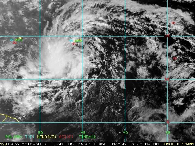
TROPICAL WEATHER DISCUSSION
NWS TPC/NATIONAL HURRICANE CENTER MIAMI FL
805 AM EDT SUN AUG 30 2009
...SPECIAL FEATURES...
AN ATLANTIC OCEAN TROPICAL WAVE GOES FROM 16N42W TO A 1009 MB
LOW PRESSURE CENTER NEAR 11N44W TO 7N49W MOVING WEST 15 TO 20 KT.
STRONG SHOWERS AND THUNDERSTORMS ARE FROM 10N TO 13N BETWEEN
45W AND 48W. ISOLATED MODERATE SHOWERS TO LOCALLY STRONG
THUNDERSTORMS ARE ELSEWHERE FROM 10N TO 17N BETWEEN 40W AND
50W...AND FROM 7N TO 11N BETWEEN 50W AND 57W IN WHAT APPEARS
TO BE POSSIBLY ITCZ PRECIPITATION THAT IS BEING ENHANCED AND/OR
PUSHED NORTHWARD BY THE LOW CENTER/TROPICAL WAVE SYSTEM. THE
CHANCE FOR THIS SYSTEM TO BECOME A TROPICAL CYCLONE DURING THE
NEXT 48 HOURS IS MEDIUM.
There is no question that the discussion is done well before the TWO
0 likes

Re: ATL : INVEST 94L (Code Red)
The only model that brings 94L into the northern LA is the Euro as a weak system. The CMC, NOGAPs, GFS, & HWRF all develop the system but move it more sharply N-NW east of the Islands. After that, the system seems to stall around 22-62 as high pressure builds in to the north. The 10-day Euro is showing 500 mb heights rising in the western atlantic and eastern US in 7-10 day period. This one (future Erika) could get interesting.
0 likes
-
cycloneye

- Admin

- Posts: 149220
- Age: 69
- Joined: Thu Oct 10, 2002 10:54 am
- Location: San Juan, Puerto Rico
Re: ATL : INVEST 94L - Computer Models
06z HWRF stalls briefly just east of Antigua and then moves NW from there as a cat 2.
http://moe.met.fsu.edu/cgi-bin/hwrftc2. ... =Animation
http://moe.met.fsu.edu/cgi-bin/hwrftc2. ... =Animation
0 likes
-
cycloneye
- Admin
- Posts: 149220
- Age: 69
- Joined: Thu Oct 10, 2002 10:54 am
- Location: San Juan, Puerto Rico
Re: ATL : INVEST 94L
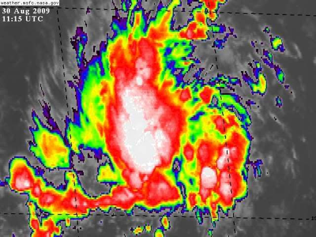
SSD Dvorak.
30/1145 UTC 11.9N 46.1W T1.5/1.5 94L -- Atlantic
http://www.ssd.noaa.gov/PS/TROP/tdpositions.html
30/1145 UTC 11.9N 46.1W T1.5/1.5 94L -- Atlantic
http://www.ssd.noaa.gov/PS/TROP/tdpositions.html
0 likes

Re: ATL : INVEST 94L
Anyone have a good image of a dunce cap. I'm sure they're out there. 
cycloneye wrote:SSD Dvorak.
30/1145 UTC 11.9N 46.1W T1.5/1.5 94L -- Atlantic
http://www.ssd.noaa.gov/PS/TROP/tdpositions.html
0 likes
-
BatzVI

- Tropical Storm

- Posts: 199
- Joined: Sat Jun 10, 2006 8:27 am
- Location: St. Thomas, Virgin Islands
Re: ATL : INVEST 94L
Cyclone....any chance of this following a Marilyn track? If you recall, it wasn't a depression until 12/50....I don't think the atmospheric conditions are the same from what I've been reading from the the mets...so, at this point, just keeping my fingers crossed....will start watching the iguanas....
0 likes
-
Derek Ortt
Re: ATL : INVEST 94L
Lurker wrote:Anyone have a good image of a dunce cap. I'm sure they're out there.cycloneye wrote:SSD Dvorak.
30/1145 UTC 11.9N 46.1W T1.5/1.5 94L -- Atlantic
http://www.ssd.noaa.gov/PS/TROP/tdpositions.html
did not become a depression within the 36 hour period used by nwhhc. So no dunce cap required
0 likes
-
cycloneye
- Admin
- Posts: 149220
- Age: 69
- Joined: Thu Oct 10, 2002 10:54 am
- Location: San Juan, Puerto Rico
Re: ATL : INVEST 94L
BatzVI wrote:Cyclone....any chance of this following a Marilyn track? If you recall, it wasn't a depression until 12/50....I don't think the atmospheric conditions are the same from what I've been reading from the the mets...so, at this point, just keeping my fingers crossed....will start watching the iguanas....
Since there are uncertaintys regarding the intensity and track,we have to watch how all evolves.And of course,keep a watch on the iguanas.
0 likes
-
cycloneye
- Admin
- Posts: 149220
- Age: 69
- Joined: Thu Oct 10, 2002 10:54 am
- Location: San Juan, Puerto Rico
Re: ATL : INVEST 94L - Computer Models
12 UTC Bam Models
Almost all are NE Caribbean bound.
618
WHXX01 KWBC 301232
CHGHUR
TROPICAL CYCLONE GUIDANCE MESSAGE
NWS TPC/NATIONAL HURRICANE CENTER MIAMI FL
1232 UTC SUN AUG 30 2009
DISCLAIMER...NUMERICAL MODELS ARE SUBJECT TO LARGE ERRORS.
PLEASE REFER TO NHC OFFICIAL FORECASTS FOR TROPICAL CYCLONE
AND SUBTROPICAL CYCLONE INFORMATION.
ATLANTIC OBJECTIVE AIDS FOR
DISTURBANCE INVEST (AL942009) 20090830 1200 UTC
...00 HRS... ...12 HRS... ...24 HRS. .. ...36 HRS...
090830 1200 090831 0000 090831 1200 090901 0000
LAT LON LAT LON LAT LON LAT LON
BAMS 11.8N 46.3W 13.4N 48.8W 14.7N 51.2W 15.9N 53.3W
BAMD 11.8N 46.3W 12.9N 48.6W 14.0N 50.8W 14.8N 52.7W
BAMM 11.8N 46.3W 12.9N 48.7W 14.0N 50.9W 14.8N 52.8W
LBAR 11.8N 46.3W 13.0N 48.7W 14.2N 51.0W 15.0N 53.1W
SHIP 25KTS 31KTS 40KTS 49KTS
DSHP 25KTS 31KTS 40KTS 49KTS
...48 HRS... ...72 HRS... ...96 HRS. .. ..120 HRS...
090901 1200 090902 1200 090903 1200 090904 1200
LAT LON LAT LON LAT LON LAT LON
BAMS 16.7N 55.0W 17.7N 57.8W 18.8N 60.6W 19.8N 63.7W
BAMD 15.4N 54.4W 16.0N 57.4W 16.7N 60.3W 17.7N 63.4W
BAMM 15.2N 54.3W 15.5N 57.1W 16.0N 60.0W 16.7N 63.6W
LBAR 15.6N 55.1W 16.2N 58.4W 16.9N 61.5W 18.5N 64.2W
SHIP 58KTS 77KTS 85KTS 86KTS
DSHP 58KTS 77KTS 85KTS 86KTS
...INITIAL CONDITIONS...
LATCUR = 11.8N LONCUR = 46.3W DIRCUR = 285DEG SPDCUR = 13KT
LATM12 = 10.8N LONM12 = 43.5W DIRM12 = 281DEG SPDM12 = 16KT
LATM24 = 10.7N LONM24 = 40.6W
WNDCUR = 25KT RMAXWD = 60NM WNDM12 = 25KT
CENPRS = 1007MB OUTPRS = 1011MB OUTRAD = 150NM SDEPTH = M
RD34NE = 0NM RD34SE = 0NM RD34SW = 0NM RD34NW = 0NM
$$
0 likes
Who is online
Users browsing this forum: No registered users and 11 guests