
Yeah looks like a decent enough estimate now we actually have a circulation to watch and observe.
Still seems most likely that this will recurve though some models are still trying to build a ridge and reduce the eastern US troughing somewhat.
ATL : TROPICAL DEPRESSION ERIKA (06L)
Moderator: S2k Moderators
-
knotimpaired

- Category 1

- Posts: 495
- Joined: Fri May 20, 2005 4:14 am
- Location: Vieques, PR
- Contact:
Re: ATL : INVEST 94L
cycloneye wrote:BatzVI wrote:Cyclone....any chance of this following a Marilyn track? If you recall, it wasn't a depression until 12/50....I don't think the atmospheric conditions are the same from what I've been reading from the the mets...so, at this point, just keeping my fingers crossed....will start watching the iguanas....
Since there are uncertaintys regarding the intensity and track,we have to watch how all evolves.And of course,keep a watch on the iguanas.
Ok Luis and Batz. Since I seem to live at the epicenter of iguanas here, what should we be looking for? Mating calls, more presence, restlessness?

0 likes


-
Derek Ortt
So 285 appears to be what is needed now for it to be a NE Caribbean threat. I personally think it will gain more latitude then that but we shall see.
What wil lbe interesting is how the upper synoptic pattern plays out once it gets past 60W, there is a weak upper trough present on the ECM (I'm guessing its stronger on the GFS though I've not really looked) but whether its enough to lift this one out totally in time before the ridge builds back in is uncertain.
What wil lbe interesting is how the upper synoptic pattern plays out once it gets past 60W, there is a weak upper trough present on the ECM (I'm guessing its stronger on the GFS though I've not really looked) but whether its enough to lift this one out totally in time before the ridge builds back in is uncertain.
0 likes
-
BatzVI

- Tropical Storm

- Posts: 199
- Joined: Sat Jun 10, 2006 8:27 am
- Location: St. Thomas, Virgin Islands
Re: ATL : INVEST 94L
In the past, I've noticed the iguanas go into kind of a feeding frenzy and get aggressive with one another...then they disappear....
0 likes
So looks like there is still some slight easterly shear present on it, should lift out around 300 once this develops even more. Its what happens later on that wil lbe really interesting, ECM is trying to develop a ridge in the western Atlantic while the GFS keeps the upper troughs rolling in till about day 8.
edit---I was looking through the old Frances threads, was interesting to see what the models progged with that and the placement of this system.
edit---I was looking through the old Frances threads, was interesting to see what the models progged with that and the placement of this system.
0 likes

-
Gustywind

- Category 5

- Posts: 12334
- Joined: Mon Sep 03, 2007 7:29 am
- Location: Baie-Mahault, GUADELOUPE
Re: ATL : INVEST 94L
BatzVI wrote:Cyclone....any chance of this following a Marilyn track? If you recall, it wasn't a depression until 12/50....I don't think the atmospheric conditions are the same from what I've been reading from the the mets...so, at this point, just keeping my fingers crossed....will start watching the iguanas....
Hi BatzVI very interresing thing about the iguanas!
Your reasoning seems interresting about a Marilyn track, and as Cycloneye mentionned it let's continue to monitor closely the situation with 94L.
0 likes

-
banksmanforever
- Tropical Low

- Posts: 22
- Joined: Tue Sep 11, 2007 7:00 pm
Re: ATL : INVEST 94L
0 likes
-
AtlanticWind

- S2K Supporter

- Posts: 1898
- Age: 67
- Joined: Sun Aug 08, 2004 9:57 pm
- Location: Plantation,Fla
Re: ATL : INVEST 94L
banksmanforever wrote:Tothe untrained eye its still going west
http://www.ssd.noaa.gov/goes/east/carb/loop-avn.html
Moving about 285 degrees , that is mainly west.
0 likes

Re: ATL : INVEST 94L - Computer Models
So far, its the ECM and BAM Med And Dp into the NE LA. Have to watch the trends over the next few model cycles. Right now, looks to be close call for the islands. SHIPS brings 94L to 87 kts in 5 days.
0 likes
-
x-y-no

- Category 5
- Posts: 8359
- Age: 65
- Joined: Wed Aug 11, 2004 12:14 pm
- Location: Fort Lauderdale, FL
Re:
Derek Ortt wrote:chances are of a miss of the Carib. Look at the extrap. Barely clips the Carib. This should turn even more to the north. I do not see much of a threat to the Carib yet
I'm not so convinced by that extrapolation, since it's extrapolating from a time when the circulation was very broad and thus positional precision was pretty low. Now that we have a somewhat tighter circulation at around 12N 46W or so, the next 12 hours should give us a more reliable extrapolated track. If that still points the same way as the current extrap, I'll be ready to believe we're looking at a miss of the islands.
0 likes
-
cycloneye

- Admin

- Posts: 149222
- Age: 69
- Joined: Thu Oct 10, 2002 10:54 am
- Location: San Juan, Puerto Rico
Re: ATL : INVEST 94L
Tropical Cyclone Formation Alert
WTNT01 KNGU 301201
SUBJ/TROPICAL CYCLONE FORMATION ALERT 301200Z AUG 09//
RMKS/
1. FORMATION OF A SIGNIFICANT TROPICAL CYCLONE IS POSSIBLE WITHIN
100 NM EITHER SIDE OF A LINE FROM 12.1N 45.2W TO 15.1N 51.5W
WITHIN 24 HOURS. AVAILABLE DATA DOES NOT JUSTIFY
ISSUANCE OF NUMBERED TROPICAL CYCLONE WARNINGS AT THIS TIME.
WINDS IN THE AREA ARE ESTIMATED TO BE 20 TO 25 KNOTS. THE SYSTEM
IS MOVING NORTHWESTWARD AT 15 KNOTS.
2. REMARKS: THE 09Z SATELLITE IMAGERY INDICATES THAT THE DEEP
CONVECTION AND A SURFACE CIRCULATION ASSOCIATED WITH THE LOW HAS
BECOME BETTER ORGANIZED OVER THE PAST 12 HOURS. SEA SURFACE
TEMPERATURES ARE RANGING FROM 28 TO 30 DEGREES CELSIUS ACROSS THE
TROPICAL ATLANTIC. UPPER LEVEL WINDS OVER THE SYSTEM ARE EAST-
SOUTHEASTERLY 25 TO 30 KTS. WINDS, HOWEVER, ARE DECREASING WEST
OF THE WAVE. AS THE WAVE CONTINUES TO TRACK TO THE WEST,
ENVIRONMENTAL CONDITIONS BECOME MORE CONDUCIVE FOR DEVELOPMENT.
3. THIS ALERT IS VALID THROUGH 311200Z.//
0 likes
-
wxman57

- Moderator-Pro Met

- Posts: 23171
- Age: 68
- Joined: Sat Jun 21, 2003 8:06 pm
- Location: Houston, TX (southwest)
Re: ATL : INVEST 94L
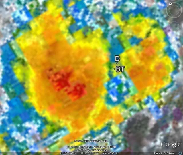
I'm estimating 12.1N/47.1W. Still consolidating. I think it qualifies for TD now. Decent banding, though convection lacking a bit.
0 likes

Re: ATL : INVEST 94L
94l is looking better than it did yesterday,However it looks like some pretty good wind shear ahead of it from that ULL to its NW.
0 likes
-
gatorcane

- S2K Supporter
- Posts: 23708
- Age: 48
- Joined: Sun Mar 13, 2005 3:54 pm
- Location: Boca Raton, FL
Re: ATL : INVEST 94L
AtlanticWind wrote:banksmanforever wrote:Tothe untrained eye its still going west
http://www.ssd.noaa.gov/goes/east/carb/loop-avn.html
Moving about 285 degrees , that is mainly west.
yeah it still seems mostly west. This is getting interesting to say the least.
Just this time yesterday this was being written off with a downgrade to code yellow. That downgrade to yellow (the fact it didn't develop as quickly as it could) has allowed it to get further west. Otherwise it was a shoe-in for a recurve comfortably east of the islands. How things change so quickly.
0 likes
Who is online
Users browsing this forum: No registered users and 12 guests