Yipes and/or ugh...
LOL
Tropical Wave north of the Greater Antilles
Moderator: S2k Moderators
Forum rules

The posts in this forum are NOT official forecasts and should not be used as such. They are just the opinion of the poster and may or may not be backed by sound meteorological data. They are NOT endorsed by any professional institution or STORM2K. For official information, please refer to products from the National Hurricane Center and National Weather Service.

Re: Strong wave emerging african coast
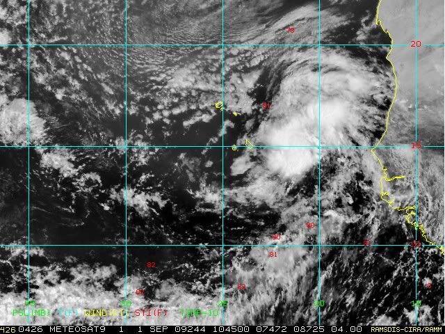
looking at high-res visibles, i would say there may be a center of low pressure near 9-10N and 20W...
0 likes
-
wayne56

- Tropical Low

- Posts: 35
- Age: 70
- Joined: Tue Aug 31, 2004 4:41 pm
- Location: Whitinsville,MA & Maryland Heights,MO
Re: Strong wave emerging african coast
Who cares? I am waiting for next year. I have a life which means many responsibilities  .
.
First, 2009 in the Atlantic Basin (AB) is the year of shear and dry air.
Second, 2009 is the year of El Nino and upper lows.
Third, 2009 will be a below normal year for tropical systems.
Finally, 2009 will be the year of watching other basins for action in the tropics.
First, 2009 in the Atlantic Basin (AB) is the year of shear and dry air.
Second, 2009 is the year of El Nino and upper lows.
Third, 2009 will be a below normal year for tropical systems.
Finally, 2009 will be the year of watching other basins for action in the tropics.
0 likes
-
weatherSnoop

- S2K Supporter

- Posts: 702
- Age: 63
- Joined: Wed Oct 09, 2002 10:06 pm
- Location: Tampa, FL
- Contact:
Re: Strong wave emerging african coast
wayne56 wrote:Who cares? I am waiting for next year. I have a life which means many responsibilities
First, 2009 in the Atlantic Basin (AB) is the year of shear and dry air.
Second, 2009 is the year of El Nino and upper lows.
Third, 2009 will be a below normal year for tropical systems.
Finally, 2009 will be the year of watching other basins for action in the tropics.
I guess it is easy to spend your time elsewhere when you live in Mo. I understand that, though the "who cares?" question can be addressed by saying all island and coastal communities. I wish you a mild winter
0 likes
-
ConvergenceZone
.gif)
- Category 5

- Posts: 5241
- Joined: Fri Jul 29, 2005 1:40 am
- Location: Northern California
I will admit that this is the slowest the storm2k boards have been in many years(as far as traffic is concerned) during the heart of hurricane season. Not that it's a bad thing, but it just goes to show how slow the tropics are. It's amazing that we are only up to the 'D' storm and tomorrow is already September.
0 likes


Re:
ConvergenceZone wrote:I will admit that this is the slowest the storm2k boards have been in many years(as far as traffic is concerned) during the heart of hurricane season. Not that it's a bad thing, but it just goes to show how slow the tropics are. It's amazing that we are only up to the 'D' storm and tomorrow is already September.
Not sure it is that amazing. Climatology speaking the "E" storm forms on September 5th. Now if we are are the D storm going into October then that would be amazing.
0 likes
-
bob rulz
- Category 5
- Posts: 1711
- Age: 35
- Joined: Sat Jan 28, 2006 7:30 pm
- Location: Salt Lake City, Utah
Re:
ConvergenceZone wrote:I will admit that this is the slowest the storm2k boards have been in many years(as far as traffic is concerned) during the heart of hurricane season. Not that it's a bad thing, but it just goes to show how slow the tropics are. It's amazing that we are only up to the 'D' storm and tomorrow is already September.
This is closer to average, we've just been spoiled by a number of exceptional seasons in recent years.
0 likes

Re: Strong wave emerging african coast
wayne56 wrote:Who cares? I am waiting for next year. I have a life which means many responsibilities
First, 2009 in the Atlantic Basin (AB) is the year of shear and dry air.
Second, 2009 is the year of El Nino and upper lows.
Third, 2009 will be a below normal year for tropical systems.
Finally, 2009 will be the year of watching other basins for action in the tropics.
This pretty much sums up my thoughts in a nutshell.
0 likes
-
ConvergenceZone
- Category 5
- Posts: 5241
- Joined: Fri Jul 29, 2005 1:40 am
- Location: Northern California
Re: Re:
Lurker wrote:ConvergenceZone wrote:I will admit that this is the slowest the storm2k boards have been in many years(as far as traffic is concerned) during the heart of hurricane season. Not that it's a bad thing, but it just goes to show how slow the tropics are. It's amazing that we are only up to the 'D' storm and tomorrow is already September.
Not sure it is that amazing. Climatology speaking the "E" storm forms on September 5th. Now if we are are the D storm going into October then that would be amazing.
Perhaps, but I still don't see any indication based upon the current patterns, amount of shear etc, that this pattern is going to change. At least in past seasons there's often indication that things are changing. I don't see any indication of that at all right now.
0 likes

Re: Strong wave emerging african coast
2002 at this time had the same number of storms all of them below hurricane strength, and then in September we had 8 named stroms including Isidore and Lili. On 2006 at this time we had 5 systems, one of them a cat 1 and the during September long-lived Helene and Gordon formed. This is typical of an El Niño and I think that eventually a system will be under favorable conditions and will intensify into a strong hurricane as Isidore, Lili, Helene, Gordon and more recentely Bill did.
0 likes
-
expat2carib

- S2K Supporter
- Posts: 458
- Joined: Tue Jul 22, 2008 1:44 pm
- Location: Sint Maarten
Re: Strong wave emerging african coast
It "ONLY" requires one storm to "destroy" ones future.
0 likes
-
wayne56
- Tropical Low
- Posts: 35
- Age: 70
- Joined: Tue Aug 31, 2004 4:41 pm
- Location: Whitinsville,MA & Maryland Heights,MO
Re: Strong wave emerging african coast
I have many friends and relatives in Miami and the Texas coastal areas and lived in both regions in my younger days back when hurricane events were rare.
Every season is different but from here in Missouri, this season should end by late September in the US. Many reasons point to this: continuous air mass intrusions in the mid-west and east coast, El Nino, and lower heat content in the tropics this year. The US has about a month for a significant TC to affect land after that, see you next year.
The coldest summer I have ever experienced was 2009 when I lived in Missouri.
0 likes

Re: Strong wave emerging african coast
wayne56 wrote:I have many friends and relatives in Miami and the Texas coastal areas and lived in both regions in my younger days back when hurricane events were rare.
Every season is different but from here in Missouri, this season should end by late September in the US. Many reasons point to this: continuous air mass intrusions in the mid-west and east coast, El Nino, and lower heat content in the tropics this year. The US has about a month for a significant TC to affect land after that, see you next year.
The coldest summer I have ever experienced was 2009 when I lived in Missouri.
I think the statement made above says it all.
It only takes one storm to ruin a season.
I also agree that it is easy for someone in Mo. to look at the season very clinically and statistically and be bored but it only takes one "Andrew" or "Katrina" for someone who lives in an area that can be struck by a hurricance to make a season VERY memorable.
Oh, and the coldest summer one would experience is one spent in San Francisco!!!

0 likes
-
cycloneye

- Admin

- Posts: 149217
- Age: 69
- Joined: Thu Oct 10, 2002 10:54 am
- Location: San Juan, Puerto Rico
Re: Strong wave emerging african coast
0 likes
-
HURAKAN

- Professional-Met

- Posts: 46084
- Age: 39
- Joined: Thu May 20, 2004 4:34 pm
- Location: Key West, FL
- Contact:
713
ABNT20 KNHC 011148
TWOAT
TROPICAL WEATHER OUTLOOK
NWS TPC/NATIONAL HURRICANE CENTER MIAMI FL
800 AM EDT TUE SEP 1 2009
FOR THE NORTH ATLANTIC...CARIBBEAN SEA AND THE GULF OF MEXICO...
A BROAD LOW PRESSURE AREA LOCATED ABOUT 275 MILES EAST OF THE
LEEWARD ISLANDS CONTINUES TO PRODUCE SHOWERS AND THUNDERSTORMS AND
WINDS TO GALE FORCE EAST OF THE CENTER. HOWEVER...MICROWAVE DATA
INDICATE THAT THE CIRCULATION IS NOT YET WELL-DEFINED AT THE
SURFACE. THIS SYSTEM COULD BECOME A TROPICAL DEPRESSION OR
TROPICAL STORM AT ANY TIME OVER THE NEXT COUPLE OF DAYS AS IT MOVES
WEST-NORTHWESTWARD AT AROUND 10 MPH. THERE IS A HIGH CHANCE...
GREATER THAN 50 PERCENT...OF TROPICAL CYCLONE FORMATION IN THIS
AREA DURING THE NEXT 48 HOURS. INTERESTS IN THE LEEWARD ISLANDS...
THE U.S. AND BRITISH VIRGIN ISLANDS...AND PUERTO RICO SHOULD
MONITOR THE PROGRESS OF THIS SYSTEM. AN AIR FORCE RESERVE
RECONNAISSANCE AIRCRAFT IS SCHEDULED TO INVESTIGATE THE LOW THIS
AFTERNOON.
A TROPICAL WAVE OVER THE FAR EASTERN ATLANTIC OCEAN BETWEEN THE CAPE
VERDE ISLANDS AND AFRICA IS SHOWING SOME SIGNS OF ORGANIZATION.
DEVELOPMENT...IF ANY...OF THIS SYSTEM IS EXPECTED TO BE SLOW TO
OCCUR AS THE SYSTEM MOVES TO THE WEST OR WEST-NORTHWEST AT 10 TO 15
MPH. THERE IS A LOW CHANCE...LESS THAN 30 PERCENT...OF THIS SYSTEM
BECOMING A TROPICAL CYCLONE DURING THE NEXT 48 HOURS.
ELSEWHERE...TROPICAL CYCLONE FORMATION IS NOT EXPECTED DURING THE
NEXT 48 HOURS.
$$
FORECASTER BLAKE
0 likes

-
otowntiger
- Category 5
- Posts: 1932
- Joined: Tue Aug 31, 2004 7:06 pm
Re:
HURAKAN wrote:
Clearly a MLC or LLC is present
That is going to be one impressive fish.
0 likes
-
ConvergenceZone
- Category 5
- Posts: 5241
- Joined: Fri Jul 29, 2005 1:40 am
- Location: Northern California
Who is online
Users browsing this forum: No registered users and 77 guests