Tropical Wave north of the Greater Antilles
Moderator: S2k Moderators
Forum rules

The posts in this forum are NOT official forecasts and should not be used as such. They are just the opinion of the poster and may or may not be backed by sound meteorological data. They are NOT endorsed by any professional institution or STORM2K. For official information, please refer to products from the National Hurricane Center and National Weather Service.
Re: Strong wave in Eastern Atlantic
Guess it did take the high route through the Cape Verde Islands.
0 likes
-
Evil Jeremy

- S2K Supporter

- Posts: 5463
- Age: 32
- Joined: Mon Apr 10, 2006 2:10 pm
- Location: Los Angeles, CA


-
Tropics Guy

- Tropical Storm

- Posts: 167
- Age: 63
- Joined: Tue Aug 31, 2004 8:12 pm
- Location: Hallandale beach & Vero beach, FL
Re: Strong wave in Eastern Atlantic
Recurve city written all over this one, the next wave to exit will come off at a lower latitude though...............
TG
TG
0 likes
-
otowntiger
- Category 5

- Posts: 1932
- Joined: Tue Aug 31, 2004 7:06 pm
Re: Strong wave in Eastern Atlantic
Tropics Guy wrote:Recurve city written all over this one,the next wave to exit will come off at a lower latitude though...............
TG
Its at the same latitude the previous one was, so it will likely follow suit.
0 likes

Re: Re:
Wow I couldn't disagree more......Check out Jeff Masters newest blog.......The first half of September could be very active. If these waves develop then a lot of the "lowcasters" poo poo'ing this season during June and July might hugely bust....lol
From Jeff Masters:
Elsewhere in the tropics
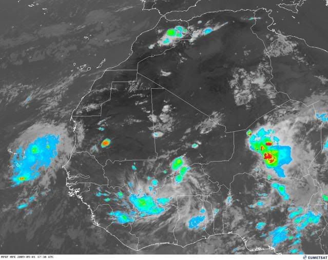
It's September, the most active month for hurricane activity in the Northern Hemisphere. There's every indication that the 2009 Atlantic hurricane season will have an active first half of September, since SSTs are 0.5 - 1.0°C above average, wind shear is near average, and the African monsoon is sending a long parade of African waves spinning off the coast of Africa. An IR satellite image from noon today shows this activity well (Figure 2). We can see a line-up of five African waves stretching from the Lesser Antilles to eastern Africa. The GFS model develops the waves numbered "2" and "3" into tropical depressions next week, and the waves labeled "1" and "4" also have a chance to develop into tropical depressions, as well. The wave labeled "1" is mentioned on NHC's Tropical Weather Outlook as having a low (less than 30%) chance of developing into a tropical depression by Thursday. This wave is under a moderate 10 - 15 knots of wind shear, and is over sufficiently warm waters (27 - 28°C) that some development may occur this week. The wave is far enough north that it will be hampered by dry air from the Sahara Desert.
http://www.wunderground.com/blog/JeffMasters/show.html
From Jeff Masters:
Elsewhere in the tropics
It's September, the most active month for hurricane activity in the Northern Hemisphere. There's every indication that the 2009 Atlantic hurricane season will have an active first half of September, since SSTs are 0.5 - 1.0°C above average, wind shear is near average, and the African monsoon is sending a long parade of African waves spinning off the coast of Africa. An IR satellite image from noon today shows this activity well (Figure 2). We can see a line-up of five African waves stretching from the Lesser Antilles to eastern Africa. The GFS model develops the waves numbered "2" and "3" into tropical depressions next week, and the waves labeled "1" and "4" also have a chance to develop into tropical depressions, as well. The wave labeled "1" is mentioned on NHC's Tropical Weather Outlook as having a low (less than 30%) chance of developing into a tropical depression by Thursday. This wave is under a moderate 10 - 15 knots of wind shear, and is over sufficiently warm waters (27 - 28°C) that some development may occur this week. The wave is far enough north that it will be hampered by dry air from the Sahara Desert.
http://www.wunderground.com/blog/JeffMasters/show.html
ConvergenceZone wrote:Lurker wrote:ConvergenceZone wrote:I will admit that this is the slowest the storm2k boards have been in many years(as far as traffic is concerned) during the heart of hurricane season. Not that it's a bad thing, but it just goes to show how slow the tropics are. It's amazing that we are only up to the 'D' storm and tomorrow is already September.
Not sure it is that amazing. Climatology speaking the "E" storm forms on September 5th. Now if we are are the D storm going into October then that would be amazing.
Perhaps, but I still don't see any indication based upon the current patterns, amount of shear etc, that this pattern is going to change. At least in past seasons there's often indication that things are changing. I don't see any indication of that at all right now.
0 likes

Re: Strong wave in Eastern Atlantic
Forget it, I thought you were in disagreement with Dr. Jeff Masters, but you disagree with what you quoted, right?
0 likes
-
HURAKAN

- Professional-Met

- Posts: 46084
- Age: 39
- Joined: Thu May 20, 2004 4:34 pm
- Location: Key West, FL
- Contact:
113
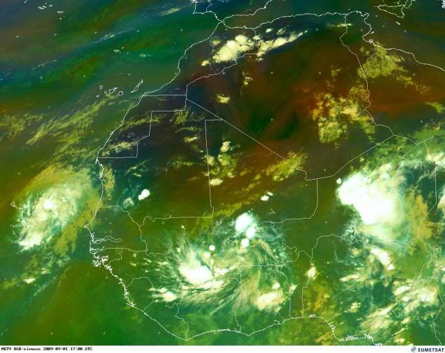
ABNT20 KNHC 012350
TWOAT
TROPICAL WEATHER OUTLOOK
NWS TPC/NATIONAL HURRICANE CENTER MIAMI FL
800 PM EDT TUE SEP 1 2009
FOR THE NORTH ATLANTIC...CARIBBEAN SEA AND THE GULF OF MEXICO...
THE NATIONAL HURRICANE CENTER IS ISSUING ADVISORIES ON NEWLY FORMED
TROPICAL STORM ERIKA LOCATED 390 MILES EAST OF THE NORTHERN LEEWARD
ISLANDS.
AN AREA OF LOW PRESSURE ASSOCIATED WITH A TROPICAL WAVE IS SPREADING
CLOUDINESS AND THUNDERSTORMS OVER THE CAPE VERDE ISLANDS. THIS
SYSTEM CONTINUES TO SHOW SOME SIGNS OF ORGANIZATION AND
DEVELOPMENT...IF ANY...EXPECTED TO BE SLOW TO OCCUR AS THE SYSTEM
MOVES TO THE WEST OR WEST-NORTHWEST AT 10 TO 15 MPH. THERE IS A LOW
CHANCE...LESS THAN 30 PERCENT...OF THIS SYSTEM BECOMING A TROPICAL
CYCLONE DURING THE NEXT 48 HOURS.
ELSEWHERE...TROPICAL CYCLONE FORMATION IS NOT EXPECTED DURING THE
NEXT 48 HOURS.
PUBLIC ADVISORIES ON ERIKA ARE ISSUED UNDER WMO HEADER WTNT31 KNHC
AND UNDER AWIPS HEADER MIATCPAT1. FORECAST/ADVISORIES ARE ISSUED
UNDER WMO HEADER WTNT21 KNHC AND UNDER AWIPS HEADER MIATCMAT1.
$$
FORECASTER AVILA
0 likes

Re: Strong wave in Eastern Atlantic
Macrocane wrote:Forget it, I thought you were in disagreement with Dr. Jeff Masters, but you disagree with what you quoted, right?
Right....I was responding to his claim that conditions don't seem favorable. Jeff Masters wrote a nice blog - if these waves develop then the calls for 9-10 storm season could bust.
0 likes
-
Evil Jeremy
- S2K Supporter
- Posts: 5463
- Age: 32
- Joined: Mon Apr 10, 2006 2:10 pm
- Location: Los Angeles, CA
-
Evil Jeremy
- S2K Supporter
- Posts: 5463
- Age: 32
- Joined: Mon Apr 10, 2006 2:10 pm
- Location: Los Angeles, CA
-
HURAKAN
- Professional-Met
- Posts: 46084
- Age: 39
- Joined: Thu May 20, 2004 4:34 pm
- Location: Key West, FL
- Contact:
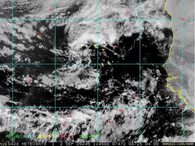
TROPICAL WEATHER DISCUSSION
NWS TPC/NATIONAL HURRICANE CENTER MIAMI FL
205 PM EDT THU SEP 03 2009
TROPICAL WAVE IS ALONG 32W S OF 19N MOVING W NEAR 15 KT. A 1014
MB LOW IS ALONG THE WAVE AXIS NEAR 14N. THE WAVE COINCIDES WITH
A DEEP LAYER MOISTURE MAXIMUM OBSERVED IN TOTAL PRECIPITABLE
WATER IMAGERY...HOWEVER...VISIBLE SATELLITE IMAGERY INDICATES A
DRY SAHARAN AIR LAYER SURROUNDING THE WAVE...THUS INHIBITING ANY
SIGNIFICANT DEEP CONVECTION. MOST SCATTERED SHOWERS AND WIDELY
SCATTERED MODERATE CONVECTION ARE EMBEDDED WITHIN THE ITCZ FROM
5N-11N BETWEEN 26W-36W.
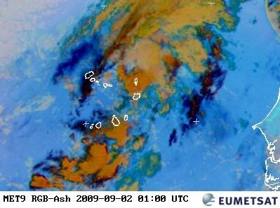
Poor wave. SAL is on the attack!
NWS TPC/NATIONAL HURRICANE CENTER MIAMI FL
205 PM EDT THU SEP 03 2009
TROPICAL WAVE IS ALONG 32W S OF 19N MOVING W NEAR 15 KT. A 1014
MB LOW IS ALONG THE WAVE AXIS NEAR 14N. THE WAVE COINCIDES WITH
A DEEP LAYER MOISTURE MAXIMUM OBSERVED IN TOTAL PRECIPITABLE
WATER IMAGERY...HOWEVER...VISIBLE SATELLITE IMAGERY INDICATES A
DRY SAHARAN AIR LAYER SURROUNDING THE WAVE...THUS INHIBITING ANY
SIGNIFICANT DEEP CONVECTION. MOST SCATTERED SHOWERS AND WIDELY
SCATTERED MODERATE CONVECTION ARE EMBEDDED WITHIN THE ITCZ FROM
5N-11N BETWEEN 26W-36W.
Poor wave. SAL is on the attack!
0 likes
-
HURAKAN
- Professional-Met
- Posts: 46084
- Age: 39
- Joined: Thu May 20, 2004 4:34 pm
- Location: Key West, FL
- Contact:
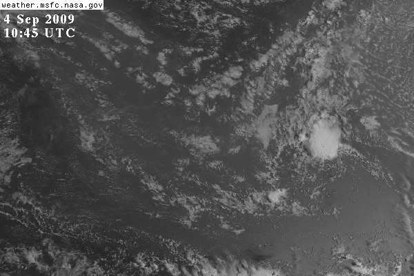
TROPICAL WEATHER DISCUSSION
NWS TPC/NATIONAL HURRICANE CENTER MIAMI FL
805 AM EDT FRI SEP 04 2009
TROPICAL WAVE IS ALONG 34W/35W S OF 18N WITH A 1011 MB LOW ALONG
THE WAVE NEAR 14N MOVING W NEAR 10 KT. THE WAVE COINCIDES WITH A
DEEP LAYER MOISTURE MAXIMUM OBSERVED IN TOTAL PRECIPITABLE WATER
IMAGERY. HOWEVER...SATELLITE IMAGERY AND THE TPW IMAGERY
INDICATE DRY SAHARAN AIR LAYER HAS BEING INJECTED INTO THE WAVE
JUST S OF THE LOW LEVEL CENTER. SCATTERED MODERATE/ISOLATED
STRONG CONVECTION IS FROM 15N-17N BETWEEN 34W-36W.
0 likes
Who is online
Users browsing this forum: No registered users and 106 guests