ATL : TROPICAL DEPRESSION ERIKA (06L)

Moderator: S2k Moderators

Message
Author
User avatar
HURAKAN
Professional-Met
Professional-Met
Posts: 46086
Age: 38
Joined: Thu May 20, 2004 4:34 pm
Location: Key West, FL
Contact:

Re: Re:

#3021 Postby HURAKAN » Wed Sep 02, 2009 8:54 am

Gustywind wrote:Any link please my friend?


go to this link http://wxgr.nl/?weer_recon.htm

and download to Google Earth "kmz file"

The storm symbol is from Global Tropical Storms and you need to download that from Guiweather http://www.guiweather.com/kml.html
0 likes   

User avatar
Sabanic
Category 2
Category 2
Posts: 683
Age: 65
Joined: Wed Aug 01, 2007 7:01 am
Location: Mobile, AL
Contact:

Re: ATL : TROPICAL STORM ERIKA - Computer Models

#3022 Postby Sabanic » Wed Sep 02, 2009 8:55 am

Blown_away wrote:Image

For now, the "All Clear For Florida" has been discontinued.


Kind of makes you wonder about the GOM down the road too . . .
0 likes   

shah8
Category 1
Category 1
Posts: 363
Joined: Wed Aug 30, 2006 4:36 pm

#3023 Postby shah8 » Wed Sep 02, 2009 8:57 am

This is reminding me too much of Fay, Dolly, and Hanna.
0 likes   

User avatar
storms NC
Tropical Storm
Tropical Storm
Posts: 247
Age: 69
Joined: Tue Sep 14, 2004 2:41 pm
Location: Coast of NC & southwest coast of Fla

Re: ATL : TROPICAL STORM ERIKA (06L)

#3024 Postby storms NC » Wed Sep 02, 2009 8:58 am

OuterBanker wrote:
dekeoy wrote:seems she's got our NWS office's attention to a point.

AREA FORECAST DISCUSSION
NATIONAL WEATHER SERVICE WILMINGTON NC
742 AM EDT WED SEP 2 2009


.LONG TERM /SATURDAY THROUGH TUESDAY/...
AS OF 3 AM WEDNESDAY...THE MID LEVEL FLOW REMAINS FROM THE SOUTHWEST
THROUGHOUT THE PERIOD WHICH GENERALLY MEANS A MOIST AND UNSETTLED
FLOW. HOWEVER...A SECOND ROUND OF STRONG WEDGING IS BEING
ADVERTISED BY THE GFS FOR LATE SUNDAY INTO MONDAY AS MID LEVEL
CONFLUENCE STRENGTHENS OVER THE NORTHEAST. OVERALL...HAVE TRENDED
DOWN ON THE POPS A BIT FOR SUNDAY INTO MONDAY VIA THE DRY SURFACE
HIGH BUILDING IN ONCE AGAIN...WITH NO OTHER CHANGES. TEMPERATURE
TRENDS LOOK GOOD WITH A BRIEF RETURN TO SEASONAL VALUES SATURDAY
INTO SUNDAY TRENDING DOWN ONCE AGAIN EARLY NEXT WEEK. IT APPEARS
AT THIS POINT TROPICAL STORM ERIKA...WITH HER SLOW MOVEMENT...WILL
NOT BE AN IMMEDIATE CONCERN THROUGH THIS TIME FRAME.


This a good thing, that it is of no concern through monday. But a little misleading, it means that it won't affect us through Monday.


That statement will mean that we won't have to worry about any hype keeping tourists away this weekend, also a good thing.If the CMC comes true she will track down the center of the Bahamas and off Miami failrly strong, most others are slightly north. GFDL is still on drugs and too strong I think.


That why they did put that in there. For the last few week ends has hurt them bad and with this week end being a long weekend they didn't want to run the people away.This is the last big week end for the beach's. There would be no way that she would be here before then.
But I do feel that this time some where is going to get a hit along the SE coast. 3rd time is the charm. JMO not worth much
0 likes   

User avatar
jabber
Category 2
Category 2
Posts: 688
Joined: Mon Mar 24, 2003 5:36 pm
Location: Raleigh, NC (former Boynton Beach, Fl)

Re: ATL : TROPICAL STORM ERIKA (06L)

#3025 Postby jabber » Wed Sep 02, 2009 8:58 am

It appears that the main source of convection is fading and a new area is forming just a bit south of the forcast plot. Maybe closer to the LLC?
0 likes   

Stormcenter
S2K Supporter
S2K Supporter
Posts: 6684
Joined: Wed Sep 03, 2003 11:27 am
Location: Houston, TX

Re:

#3026 Postby Stormcenter » Wed Sep 02, 2009 9:00 am

But conditions will only get worse and not better for Erika as she moves westward. IMO


hurricanetrack wrote:SHIPS makes it a hurricane. GFDL and HWRF make it a major hurricane. Conditions look like they will be favorable in THOSE models. The storm is holding on quite well despite the overwhelming amount of apparent dry air all around it. Look at the WV pic: http://www.ssd.noaa.gov/goes/east/tatl/wv-l.jpg

Nothing but dry air surrounding this thing. It is my guess that the intensity models are not aware of this and assume everything else to be quite ripe so up they go with intensity. Can someone post the SHIPS shear output again? Seems to me that if it were not going to survive it would have died by now. It's not moving west at 28 mph like Ana. It's not weak and half-baked like Danny, it's not Ingrid in 2007 with 750 mph winds over the top of it (joke of course). It has made it this far and is doing quite well against a pattern that is not favorable for strengthening. Get it to 70W or beyond and let's see what happens. The trend has been for this to get better organized and strengthen every day since we first started tracking it. Why would it stop now? Folks in the Bahamas had better hope those intensity models are clueless otherwise a lot of people are in for a rude awakening down the road.
0 likes   

User avatar
HURAKAN
Professional-Met
Professional-Met
Posts: 46086
Age: 38
Joined: Thu May 20, 2004 4:34 pm
Location: Key West, FL
Contact:

#3027 Postby HURAKAN » Wed Sep 02, 2009 9:03 am

Image

Latest
0 likes   

Stormcenter
S2K Supporter
S2K Supporter
Posts: 6684
Joined: Wed Sep 03, 2003 11:27 am
Location: Houston, TX

Re: ATL : TROPICAL STORM ERIKA - Computer Models

#3028 Postby Stormcenter » Wed Sep 02, 2009 9:03 am

There will be a trough (another one) in the GOM sometime next week that will bring some more nice healthy shear into the area. The funny thing is this thing may not even make that far west to begin with anyway.

Sabanic wrote:
Blown_away wrote:Image

For now, the "All Clear For Florida" has been discontinued.


Kind of makes you wonder about the GOM down the road too . . .
0 likes   

BigB0882
S2K Supporter
S2K Supporter
Posts: 2284
Joined: Thu Jul 03, 2003 12:08 am
Location: Baton Rouge, LA
Contact:

#3029 Postby BigB0882 » Wed Sep 02, 2009 9:03 am

Well these shifts mean I will definitely be keeping an eye on this one.
0 likes   

Stormcenter
S2K Supporter
S2K Supporter
Posts: 6684
Joined: Wed Sep 03, 2003 11:27 am
Location: Houston, TX

Re:

#3030 Postby Stormcenter » Wed Sep 02, 2009 9:05 am

I think you'll be just fine in Baton Rouge. :)

BigB0882 wrote:Well these shifts mean I will definitely be keeping an eye on this one.
0 likes   

User avatar
Evil Jeremy
S2K Supporter
S2K Supporter
Posts: 5463
Age: 32
Joined: Mon Apr 10, 2006 2:10 pm
Location: Los Angeles, CA

Re: Re:

#3031 Postby Evil Jeremy » Wed Sep 02, 2009 9:05 am

Stormcenter wrote:But conditions will only get worse and not better for Erika as she moves westward. IMO


Yea well, 2 nights ago we thought that the shear would obliterate 94L. Conditions keep on changing, so nothing is definite.
0 likes   

User avatar
tailgater
S2K Supporter
S2K Supporter
Posts: 3339
Joined: Sun Jul 11, 2004 9:13 pm
Location: St. Amant La.

Re: ATL : TROPICAL STORM ERIKA (06L)

#3032 Postby tailgater » Wed Sep 02, 2009 9:06 am

The Vortex /eddy /center that we were tracking earlier near Gautalope sp? is now fading and the broader center to the east is gaining convection.
radar
http://www.meteo.fr/temps/domtom/antill ... SAIC2.html
0 likes   

User avatar
hurricanefloyd5
Category 5
Category 5
Posts: 1659
Age: 44
Joined: Sun May 02, 2004 10:53 am
Location: Spartanburg
Contact:

Re: ATL : TROPICAL STORM ERIKA (06L)

#3033 Postby hurricanefloyd5 » Wed Sep 02, 2009 9:07 am

AREA FORECAST DISCUSSION
NATIONAL WEATHER SERVICE MELBOURNE FL
512 AM EDT WED SEP 2 2009


SUN-WED...BROAD TROUGH REDEVELOPING OVER THE CTRL-ERN CONUS WILL
FLATTEN OUT THE WRN PORTION OF THE MID/UPR RIDGE OVER FL. AT THE
SFC...LGT ERLY FLOW SEEMS LKLY TO PREVAIL THRU THE BEGINNING OF
NEXT WEEK...WITH POPS GENERALLY CLOSE TO CLIMO. MAIN CAVEAT W/R/T
THE XTD RANGE FCST WILL BE EVOLUTION OF T.S. "ERIKA" CURRENTLY NEAR
THE NRN LEEWARD ISLANDS. CURRENT NHC FCST PLACES SYSTEM AT 24.5N
71.0W AS A 45KT T.S. SUN EVENING...AND IN A FAIRLY HOSTILE U/L
ENVIRONMENT.
THIS MIGHT ARGUE FOR A LESS COHERENT T.C. THAN WHAT THE
USUALLY MORE RELIABLE ECM SUGGESTS...AND PERHAPS A CLOSER APPROACH
TO THE BAHAMA CHAIN. IN FACT...WHILE THE 00Z ECM STILL GOES WITH A
RECURVE SCENARIO...IT DOES SO ABOUT 3 DEGREES FARTHER WEST (75W AS
OPPOSED TO 72W).
WILL BE SOMETHING TO WATCH THRU NEXT WEEK. AS
ALWAYS...PLEASE REFER TO OFFICIAL NHC FORECASTS/DISCUSSIONS ON T.S.
ERIKA FOR ADDITIONAL INFORMATION.
0 likes   

User avatar
MGC
S2K Supporter
S2K Supporter
Posts: 5899
Joined: Sun Mar 23, 2003 9:05 pm
Location: Pass Christian MS, or what is left.

Re: ATL : TROPICAL STORM ERIKA (06L)

#3034 Postby MGC » Wed Sep 02, 2009 9:07 am

Another train wreck of a system....MGC
0 likes   

Sanibel
Category 5
Category 5
Posts: 10375
Joined: Mon Aug 30, 2004 11:06 pm
Location: Offshore SW Florida

Re: ATL : TROPICAL STORM ERIKA - Computer Models

#3035 Postby Sanibel » Wed Sep 02, 2009 9:08 am

If the GFDL is towards Florida watch out. But it could still recurve.
0 likes   

mattpetre
Category 2
Category 2
Posts: 510
Age: 53
Joined: Mon Sep 19, 2005 3:20 pm
Location: Missouri City,TX & Galleria
Contact:

Re: ATL : TROPICAL STORM ERIKA - Computer Models

#3036 Postby mattpetre » Wed Sep 02, 2009 9:08 am

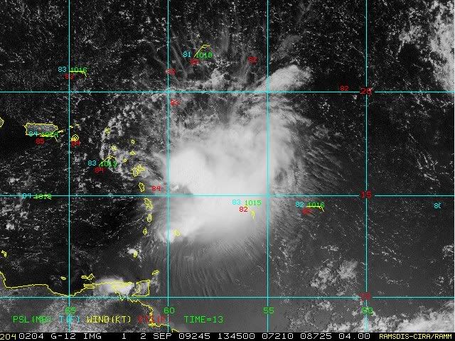
Stormcenter wrote:There will be a trough (another one) in the GOM sometime next week that will bring some more nice healthy shear into the area. The funny thing is this thing may not even make that far west to begin with anyway.


Yes, I would guess that statistically speaking there is almost as much of a chance of that trough leaving remnants that become tropical in the GOM as there is of Erika becoming a factor there. Thing is for now we only have Erika and Jimena to watch so we have to wonder what Erika will do. Admittedly she is one of those storms that has surprised on a number of occasions thus far and now we have to expect a few more up her sleeve.
0 likes   

User avatar
lrak
S2K Supporter
S2K Supporter
Posts: 1770
Age: 58
Joined: Thu Jun 21, 2007 2:48 pm
Location: Corpus Christi, TX

Re: ATL : TROPICAL STORM ERIKA (06L)

#3037 Postby lrak » Wed Sep 02, 2009 9:08 am

With my amateur satellite skills :ggreen: what is pushing this storm further south than planned? The ULL low to her NE?
0 likes   

User avatar
artist
Category 5
Category 5
Posts: 9792
Joined: Mon Jun 06, 2005 3:26 pm
Location: West Palm

#3038 Postby artist » Wed Sep 02, 2009 9:09 am

what does the latest euro show?
0 likes   

Sanibel
Category 5
Category 5
Posts: 10375
Joined: Mon Aug 30, 2004 11:06 pm
Location: Offshore SW Florida

Re: ATL : TROPICAL STORM ERIKA (06L)

#3039 Postby Sanibel » Wed Sep 02, 2009 9:14 am

Beware! Beware! Another naked spiral Danny approaches! :ggreen:
0 likes   

Aric Dunn
Category 5
Category 5
Posts: 21238
Age: 42
Joined: Sun Sep 19, 2004 9:58 pm
Location: Ready for the Chase.
Contact:

#3040 Postby Aric Dunn » Wed Sep 02, 2009 9:16 am

Good morning, evening, or Night .. all

:)

well hope we have all thrown the models out at this point .. lol
0 likes   


Return to “2009”

Who is online

Users browsing this forum: No registered users and 2 guests