seems to have lost the good inflow it did yesterday
a low level easterly jet associated with a SAL surge does that every time. I have no clue what this will do now
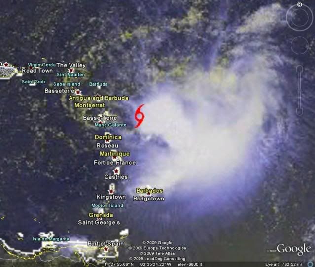
ATL : TROPICAL DEPRESSION ERIKA (06L)
Moderator: S2k Moderators
You must be speaking of someone else - this has never looked that impressive, other than a few days ago when the MLC was showing decent banding, but other than that, it's similar to Danny when it comes to disorganization, so don't be surprised if they do downgrade it, since it's very poorly organized (even for a TD) at this time...
Frank
Frank
0 likes
-
'CaneFreak

- Category 5

- Posts: 1487
- Joined: Mon Jun 05, 2006 10:50 am
- Location: New Bern, NC
Re:
Derek Ortt wrote:seems to have lost the good inflow it did yesterday
a low level easterly jet associated with a SAL surge does that every time. I have no clue what this will do now
well...you have support for the dry air this time...see the sounding posted above
0 likes
-
'CaneFreak
- Category 5
- Posts: 1487
- Joined: Mon Jun 05, 2006 10:50 am
- Location: New Bern, NC
Re:
Frank2 wrote:You must be speaking of someone else - this has never looked that impressive, other than a few days ago when the MLC was showing decent banding, but other than that, it's similar to Danny when it comes to disorganization, so don't be surprised if they do downgrade it, since it's very poorly organized (even for a TD) at this time...
Frank
This is a joke right? You aren't serious...you can't be...
0 likes
-
Evil Jeremy

- S2K Supporter

- Posts: 5463
- Age: 32
- Joined: Mon Apr 10, 2006 2:10 pm
- Location: Los Angeles, CA
-
HURAKAN

- Professional-Met

- Posts: 46084
- Age: 39
- Joined: Thu May 20, 2004 4:34 pm
- Location: Key West, FL
- Contact:
786
NOUS42 KNHC 021430
WEATHER RECONNAISSANCE FLIGHTS
CARCAH, NATIONAL HURRICANE CENTER, MIAMI, FL.
1030 AM EDT WED 02 SEPTEMBER 2009
SUBJECT: TROPICAL CYCLONE PLAN OF THE DAY (TCPOD)
VALID 03/1100Z TO 04/1100Z SEPTEMBER 2009
TCPOD NUMBER.....09-097
I. ATLANTIC REQUIREMENTS
1. TROPICAL STORM ERIKA
FLIGHT ONE - TEAL 76
A. 03/1800Z, 04/0000Z
B. AFXXX 0506A ERIKA
C. 03/1700Z
D. 17.7N 63.57W
E. 03/1715Z TO 03/2345Z
F. SFC TO 10,000 FT
FLIGHT TWO - TEAL 77
A. 04/0600Z, 1200Z
B. AFXXX 0606A ERIKA
C. 04/0500Z
D. 18.3N 64.8W
E. 04/0515Z TO 04/1145Z
F. SFC TO 10,000 FT
2. OUTLOOK FOR SUCCEEDING DAY: CONTINUE 6-HRLY FIXES
IF SYSTEM REMAINS A THREAT.
II. PACIFIC REQUIREMENTS
1. NEGATIVE RECONNAISSANCE REQUIREMENTS.
2. SUCCEEDING DAY OUTLOOK.....NEGATIVE.
3. REMARKS: MISSION FOR 02/1800Z ON HURRICANE
JIMENA CANCELED BY NHC AT 02/1130Z.
JWP
0 likes
-
Aric Dunn
- Category 5
- Posts: 21238
- Age: 43
- Joined: Sun Sep 19, 2004 9:58 pm
- Location: Ready for the Chase.
- Contact:
Re:
HURAKAN wrote:The center found by RECON is under the convection or very close to it, not the one over the Lesser Antilles. Strong convection is developing over the estimated position of the center, therefore, the NHC won't downgrade the system to TD without RECON information.
yeah even though there is clearly a vortex rotating sw the ball of convection that is firing is the main center or at least more dominate.
the models are just not going to have a easy time at all for the 12z run this is farther south than any model except the bam models from 3 days ago when they had it entering the NE carrib.
expect yet another shift west and south .. possibly across DR which does not bode well for strengthening...
not withstanding the potential for this entering the gulf if it hold together is increasing quickly and of course the bahamas and florida before that.
Last edited by Aric Dunn on Wed Sep 02, 2009 9:35 am, edited 1 time in total.
0 likes
-
TreasureIslandFLGal

- S2K Supporter
- Posts: 1584
- Age: 58
- Joined: Sun Aug 15, 2004 6:16 pm
- Location: Cancun, Mexico (northeast Yucatan coast)
Re: ATL : TROPICAL STORM ERIKA - Computer Models
Frank2 wrote:All of the above is depending on whether there's anything left of this system - it's not even a decent-looking TD at this point:
http://www.ssd.noaa.gov/goes/flt/t2/flash-vis.html
uh Frank, you do know this has a name, right? certainly beyond a TD.
0 likes
-
Portastorm

- Storm2k Moderator

- Posts: 9954
- Age: 63
- Joined: Fri Jul 11, 2003 9:16 am
- Location: Round Rock, TX
- Contact:
Re: ATL : TROPICAL STORM ERIKA - Computer Models
Stormcenter wrote:This is an excerpt from the NWS discussion this morning out of N.O.
THE OTHER FEATURE IS TS ERIKA. DEFINITELY NOT AN IMMEDIATE THREAT
IF AT ALL. A STRENGTHENING UPPER TROUGH SHOULD BE MOVING INTO THE
AREA BY THE START OF THE WEEK. IF ERIKA WERE TO GET CLOSE TO THE
GULF...THE UPPER TROUGH WOULD HAVE AN EFFECT ON IT. OFCOURSE TIMING
IS ALWAYS THE ISSUE.Portastorm wrote:Stormcenter wrote:There will be a trough (another one) in the GOM sometime next week that will bring some more nice healthy shear into the area. The funny thing is this thing may not even make that far west to begin with anyway.
There will? Where? I just looked at the 500mb and 850 mb patterns for next week from the last few GFS runs and there is no trough in the Gulf. The 0z run deepens a trough about Sept. 12th other than that ... the pattern is more ridging than anything else.
Yes, I can read
I just don't think you can post with these certain statements like "oh don't worry ... this thing will never do blah-blah-blah." It is obvious to me at least that Erika could threaten the Gulf as much as she could Bermuda. Way too many uncertainties right now. And as for shear projections ... ha, you should have seen how well those work. Yesterday there was forecasted to be significant shear over Erika and she blew up big time, confounding the pros. Those shear maps are far from gospel.
0 likes
-
tolakram
- Admin

- Posts: 20176
- Age: 62
- Joined: Sun Aug 27, 2006 8:23 pm
- Location: Florence, KY (name is Mark)
Re: ATL : TROPICAL STORM ERIKA (06L)
Taking a far off view:
edit: changed to a link
http://cimss.ssec.wisc.edu/tropic/real- ... t72hrs.gif
It's interesting that the system seems to me continually moving due west except for a stair step a day or so ago.
edit: changed to a link
http://cimss.ssec.wisc.edu/tropic/real- ... t72hrs.gif
It's interesting that the system seems to me continually moving due west except for a stair step a day or so ago.
Last edited by tolakram on Wed Sep 02, 2009 10:25 am, edited 2 times in total.
0 likes
-
ConvergenceZone
.gif)
- Category 5
- Posts: 5241
- Joined: Fri Jul 29, 2005 1:40 am
- Location: Northern California
I don't think anyone is worried about the strength of this storm, just wondering if they will get some strong tropical storm winds and heavy rain ....It might be a good rainmaker for some. but the NHC doesn't seem to think it will amount to much as far as strength is concerned.
Last edited by ConvergenceZone on Wed Sep 02, 2009 9:43 am, edited 1 time in total.
0 likes
-
otowntiger
- Category 5
- Posts: 1932
- Joined: Tue Aug 31, 2004 7:06 pm
Re:
Derek Ortt wrote:seems to have lost the good inflow it did yesterday
a low level easterly jet associated with a SAL surge does that every time. I have no clue what this will do now
But seriously, you can't honestly say you're surprised at this system's waning and diminishing once again can you?
0 likes
It seems the trolls are alive on this board once again (they must have been on vacation the past couple of weeks)...
Sorry if it disappoints them, but the NHC isn't in the business of writing disaster novels - if the system is poorly organized they will consider downgrading it, if not for this cycle certainly the next, depending on what recon finds...
Frank
Sorry if it disappoints them, but the NHC isn't in the business of writing disaster novels - if the system is poorly organized they will consider downgrading it, if not for this cycle certainly the next, depending on what recon finds...
Frank
0 likes
-
Gustywind

- Category 5
- Posts: 12334
- Joined: Mon Sep 03, 2007 7:29 am
- Location: Baie-Mahault, GUADELOUPE
Re:
Evil Jeremy wrote:This looked great overnight, but is poor now. Still, I think it will rebound as the sun goes down like it has been doing the past few nights.
Maybe you know personnaly known this Fat Lady
0 likes
-
mattpetre
- Category 2

- Posts: 510
- Age: 54
- Joined: Mon Sep 19, 2005 3:20 pm
- Location: Missouri City,TX & Galleria
- Contact:
Re: ATL : TROPICAL STORM ERIKA (06L)
Dry air is definitely slowing any possible strengthening, but a downgrade seems unlikely and given the other current environmental conditions I would have to agree with EJ that by tonight she will ramp up a little again and then probably fall off again tomorrow and as she moves further west... but it looks to me that the shear is less to the west than it was before... ok, I'm going to have to say when Derek and wxman57 are unsure of what she'll do next then it's ludicrous for me to think I know.
0 likes
-
lrak

- S2K Supporter
- Posts: 1770
- Age: 59
- Joined: Thu Jun 21, 2007 2:48 pm
- Location: Corpus Christi, TX
Re: ATL : TROPICAL STORM ERIKA (06L)
vbhoutex, thank you. It seems no one knows wth  Thats a new one on this forum
0 likes
Who is online
Users browsing this forum: No registered users and 15 guests