ATL : TROPICAL DEPRESSION ERIKA (06L)
Moderator: S2k Moderators
- cycloneye
- Admin

- Posts: 149217
- Age: 69
- Joined: Thu Oct 10, 2002 10:54 am
- Location: San Juan, Puerto Rico
Re: ATL : TROPICAL STORM ERIKA (06L)
12 UTC Best Track
Still a Tropical Storm.
AL, 06, 2009090312, , BEST, 0, 168N, 630W, 35, 1010, TS
ftp://ftp.tpc.ncep.noaa.gov/atcf/tcweb/ ... 009.invest
Still a Tropical Storm.
AL, 06, 2009090312, , BEST, 0, 168N, 630W, 35, 1010, TS
ftp://ftp.tpc.ncep.noaa.gov/atcf/tcweb/ ... 009.invest
0 likes
- HURAKAN
- Professional-Met

- Posts: 46084
- Age: 39
- Joined: Thu May 20, 2004 4:34 pm
- Location: Key West, FL
- Contact:
Loop: http://rammb.cira.colostate.edu/ramsdis ... is_floater
The center is quite easy to see SE of St. Croix.
The center is quite easy to see SE of St. Croix.
0 likes
-
CYCLONE MIKE
- Category 5

- Posts: 2183
- Joined: Tue Aug 31, 2004 6:04 pm
- Location: Gonzales, LA
Re: ATL : TROPICAL STORM ERIKA - Computer Models
Well according to the New Olreans office NWS if whatevers left of Erika trys to enter the gulf they don't think it will be there long next week.
.LONG TERM...
THE OTHER ADDITION TO ALL THIS IS AN EASTERLY WAVE THAT HAS SO FAR
BEEN RELATIVELY INERT. IT IS CURRENTLY LOCATED AT ABOUT 80W. THIS
FEATURE WILL MOVE THROUGH THE GULF ALMOST UNDETECTED UNTIL IT
BEGINS TO COLLIDE AND REACT WITH THE OLD FRONTAL BOUNDARY LATE SAT.
A GOOD BIT OF CONVECTIVE ACTIVITY SHOULD DEVELOP FROM THIS AND
MOVE ON STORM MOTION VECTORS TO THE NE. A SFC LOW MAY EVEN DEVELOP
ALONG THE OLD BOUNDARY AND MOVE NE THROUGH THE COASTAL WATERS SUN
AND MON. THIS SFC LOW LOOKS TILTED SOMWHAT BACK TO THE WEST AND
EVEN HAS A SFC TROUGH ATTACHED WHICH RELATES MORE WITH A BAROCLINIC
SYSTEM THAN A TRUE TROPICAL ONE...BUT HAS A STRONG DEEP TROPICAL
FETCH THAT IT TAKES FULL ADVANTAGE OF. THIS WILL ALL CAUSE A
STRONG UPPER VORT TO DROP TO THE BASE OF THE CURRENT UPPER LONG
WAVE TROUGH REINFORCING IT A BIT.
THEN ENTERS ERIKA OR THE REMNANTS THEREOF TUE INTO WED. THE ERIKA
MESS GETS PICKED UP BY THE LONG WAVE TROUGH AND USHERS IT
NORTHWARD. THIS IN TURN CAUSES A HUGE MASS OF DENSE COOL DRY AIR
TO BE DISPLACED FROM WELL NORTH OF THE AREA AND MOVE SOUTH. A
HUGE(WINTERLIKE) UPPER TROUGH THEN BEGINS TO DEVELOP AND DROPS
WELL INTO THE GULF BY FRI OF NEXT WEEK WITH ONE OF THE STRONGEST
TRUE COLD FRONTS SEEN IN A WHILE FOR THIS EARLY IN SEP. CONFIDENCE
IS FAIRLY HIGH WITH THIS UPPER TROUGH FEATURE DEVELOPING AND MORE
OR LESS WITH THE FINAL PATH OF ERIKA.
This definitetly sounds like it could shut the door for any gulf or east coast threats for a while.
0 likes
- srainhoutx
- S2K Supporter

- Posts: 6919
- Age: 68
- Joined: Sun Jan 14, 2007 11:34 am
- Location: Haywood County, NC
- Contact:
Re:
jasons wrote:I dunno if this has been mentioned, but the San Juan sounding today looks more like the Guadalupe sounding yesterday with a layer of dry air (SAL) imbedded in the LLJ. It's not as strong as yesterday but it could give Erika a hard time again today.
I noticed that Jason. Erika has had a hard battle with SAL and mid level shear, yet continues to survive given the demise that many have forecast for it. Another interesting day ahead.
0 likes
- storms NC
- Tropical Storm

- Posts: 247
- Age: 70
- Joined: Tue Sep 14, 2004 2:41 pm
- Location: Coast of NC & southwest coast of Fla
Re: ATL : TROPICAL STORM ERIKA (06L)
JIMO Not a NHC forcast
From looking at the vp and the wv loop she is building herself back up. Her size is growing. I don't see her lossing out here. She must be one tuff girl.Her out flow is better. Now if she would just make her mine up to where she wants to stay at with her LLC. They now have her at 16.9 and 63.1 if she stays going W-NW 295 degrees should pass just to the east of PR but just off the coast of there. She may die out but she don't look like it right now. She looks better than she did a 6AM. I will say she will not go down to a open wave as of right now.JIMO not a NHC forcast.

From looking at the vp and the wv loop she is building herself back up. Her size is growing. I don't see her lossing out here. She must be one tuff girl.Her out flow is better. Now if she would just make her mine up to where she wants to stay at with her LLC. They now have her at 16.9 and 63.1 if she stays going W-NW 295 degrees should pass just to the east of PR but just off the coast of there. She may die out but she don't look like it right now. She looks better than she did a 6AM. I will say she will not go down to a open wave as of right now.JIMO not a NHC forcast.

Last edited by storms NC on Thu Sep 03, 2009 7:54 am, edited 1 time in total.
0 likes
- Blown Away
- S2K Supporter

- Posts: 10253
- Joined: Wed May 26, 2004 6:17 am
Re: ATL : TROPICAL STORM ERIKA (06L)
cycloneye wrote:12 UTC Best Track
Still a Tropical Storm.
AL, 06, 2009090312, , BEST, 0, 168N, 630W, 35, 1010, TS
ftp://ftp.tpc.ncep.noaa.gov/atcf/tcweb/ ... 009.invest
16.8N/63W, that puts the center under the W side of the deep convection, yesterday the center was mostly exposed. IMO, the center looks like it is is going to miss Hispaniola to the N.
0 likes
- cycloneye
- Admin

- Posts: 149217
- Age: 69
- Joined: Thu Oct 10, 2002 10:54 am
- Location: San Juan, Puerto Rico
Re: ATL : TROPICAL STORM ERIKA (06L)
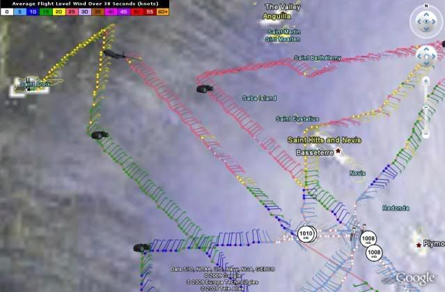
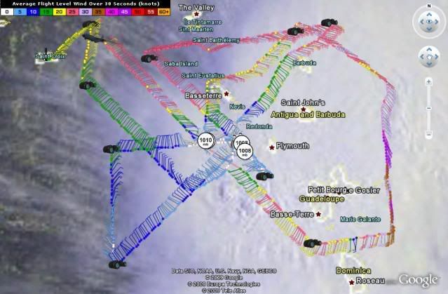
This pass was made at 6:35 AM EDT.It shows a better defined circulation,not as elongated as in the past few days.


0 likes
-
caneman
Re: ATL : TROPICAL STORM ERIKA (06L)
Not to be too much of a nasayer but read this taken from the 8:00 NHC discussion:
"ERIKA IS POORLY-DEFINED AND MAY BE OPENING UP INTO A TROUGH ORIENTED FROM
SOUTH-SOUTHWEST TO NORTH-NORTHEAST."
"ERIKA IS POORLY-DEFINED AND MAY BE OPENING UP INTO A TROUGH ORIENTED FROM
SOUTH-SOUTHWEST TO NORTH-NORTHEAST."
0 likes
- Blown Away
- S2K Supporter

- Posts: 10253
- Joined: Wed May 26, 2004 6:17 am
Re: ATL : TROPICAL STORM ERIKA - Computer Models
Seems recent models (06z) have swung back to recurve from CONUS if anything develops. 
0 likes
-
Dean4Storms
- S2K Supporter

- Posts: 6358
- Age: 63
- Joined: Sun Aug 31, 2003 1:01 pm
- Location: Miramar Bch. FL
- BatzVI
- Tropical Storm

- Posts: 199
- Joined: Sat Jun 10, 2006 8:27 am
- Location: St. Thomas, Virgin Islands
Re: ATL : TROPICAL STORM ERIKA (06L)
For those who may be interested in seeing how Erika progresses through the day...here are 2 webcams...one from the town side (south) of St. Thomas and one from Magen's Bay that shows the northside of St. Thomas
http://reservationsbvi.com/web%20cams/s ... 20cam.html
http://reservationsbvi.com/web%20cams/M ... 20Cam.html
http://reservationsbvi.com/web%20cams/s ... 20cam.html
http://reservationsbvi.com/web%20cams/M ... 20Cam.html
0 likes
- storms NC
- Tropical Storm

- Posts: 247
- Age: 70
- Joined: Tue Sep 14, 2004 2:41 pm
- Location: Coast of NC & southwest coast of Fla
Re: ATL : TROPICAL STORM ERIKA (06L)
caneman wrote:Not to be too much of a nasayer but read this taken from the 8:00 NHC discussion:
"ERIKA IS POORLY-DEFINED AND MAY BE OPENING UP INTO A TROUGH ORIENTED FROM
SOUTH-SOUTHWEST TO NORTH-NORTHEAST."
I read that ealyer this morning But she has her own mine to what she wants to do. So far NHC has been having the hard time with her. They have said so them selfs. She looks better than she did at 6 AM when I got up.
0 likes
Who is online
Users browsing this forum: No registered users and 20 guests


