ATL : TROPICAL DEPRESSION ERIKA (06L)
Moderator: S2k Moderators
-
deltadog03

- Professional-Met

- Posts: 3580
- Joined: Tue Jul 05, 2005 6:16 pm
- Location: Macon, GA

-
Wx_Warrior
- Category 5

- Posts: 2718
- Joined: Thu Aug 03, 2006 3:58 pm
- Location: Beaumont, TX
-
HenkL
- S2K Supporter

- Posts: 2401
- Joined: Fri Sep 10, 2004 5:33 pm
- Location: Groningen, The Netherlands
- Contact:
URNT15 KNHC 031907
AF304 0506A ERIKA HDOB 17 20090903
185700 1647N 06507W 9833 00212 0075 +238 +137 055012 012 011 001 00
185730 1646N 06506W 9835 00209 0075 +240 +137 050012 012 016 000 00
185800 1644N 06505W 9844 00203 0077 +240 +137 044010 011 015 000 03
185830 1643N 06504W 9870 00175 0073 +242 +137 038009 009 016 000 03
185900 1641N 06502W 9872 00177 0074 +243 +137 025008 008 019 000 03
185930 1640N 06501W 9871 00178 0073 +244 +137 013005 007 014 000 03
190000 1639N 06459W 9869 00178 0072 +245 +137 333004 004 013 000 03
190030 1639N 06458W 9871 00175 0071 +245 +138 292003 005 011 000 00
190100 1638N 06456W 9879 00169 0071 +246 +138 274006 007 006 001 03
190130 1637N 06454W 9869 00178 0073 +248 +138 267007 007 007 001 00
190200 1635N 06453W 9871 00177 0072 +250 +139 261006 006 016 000 03
190230 1634N 06452W 9793 00246 0071 +247 +140 266007 007 013 000 03
190300 1633N 06450W 9761 00276 0074 +245 +141 270007 008 004 001 00
190330 1631N 06449W 9763 00276 0076 +244 +142 260008 009 005 001 00
190400 1630N 06448W 9764 00276 0076 +245 +141 240011 012 010 000 00
190430 1628N 06447W 9763 00276 0077 +241 +140 233010 011 012 000 00
190500 1627N 06446W 9761 00278 0076 +244 +138 232009 009 014 000 00
190530 1625N 06444W 9764 00276 0077 +245 +135 234008 009 012 000 00
190600 1624N 06443W 9761 00279 0078 +245 +133 220010 011 010 000 00
190630 1623N 06442W 9763 00278 0078 +240 +133 226010 010 016 000 00
extrapolated: 1007 hPa
0 likes
Re: ATL : TROPICAL STORM ERIKA (06L)
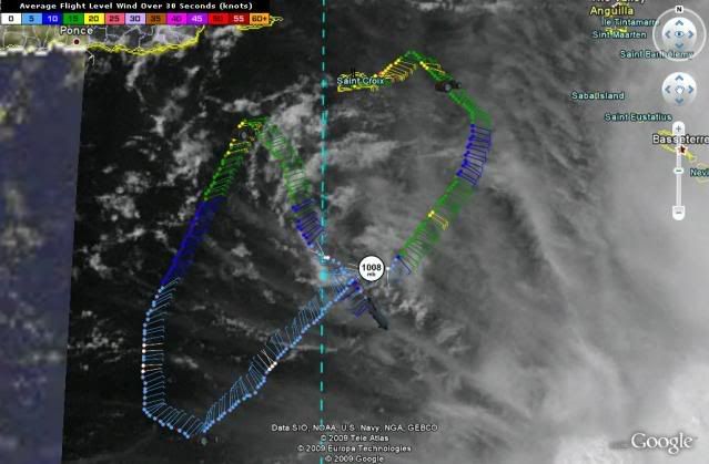
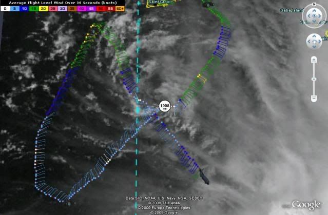
I think it was 1008 yesterday too.
If the storm still has something to it it will burst closer to the spiral later on today or tonight.
If the storm still has something to it it will burst closer to the spiral later on today or tonight.
0 likes

-
SapphireSea
- Category 1

- Posts: 430
- Joined: Wed Aug 24, 2005 12:13 pm
- Location: Miami, FL
Re: ATL : TROPICAL STORM ERIKA (06L)
The lowest pressures found by recon were 1008. Then 1010 yesterday; While there is low pressure, its more of an elongated trough of it, instead of a progressively deep and organized system. For example if this were a true weak TS, you would see pressures decrease from outside in. 1015 and then the 1008 near the center exclusively. Recon has found multiple readings of 1008 through the entirety of the convection and the system. It signifies that this is actually just a big broad open trough, or wave.
0 likes
-
Blown Away

- S2K Supporter
- Posts: 10253
- Joined: Wed May 26, 2004 6:17 am
Re:
deltadog03 wrote:Well it certainly looks like Erika is all but a remnant low now. In my forecast track I said I wouldn't be shocked if this goes back to an open wave. I still think that this has some potentiAL when it gets north of the islands.
Looking at the visible it seems the naked LLC is flying due W and almost looks like it is dissipating as we speak?? If it follows that path it will go over PR, DR, and maybe Cuba? Is it possible a new circulation comes out of the convection blob being left behind, I see some cyclonic rotation?
0 likes
-
cycloneye

- Admin

- Posts: 149211
- Age: 69
- Joined: Thu Oct 10, 2002 10:54 am
- Location: San Juan, Puerto Rico
Re: ATL : TROPICAL STORM ERIKA - Computer Models
12z NOGAPS redevelops it north of the Bahamas.
http://moe.met.fsu.edu/cgi-bin/ngptc2.c ... =Animation
http://moe.met.fsu.edu/cgi-bin/ngptc2.c ... =Animation
0 likes

-
HenkL
- S2K Supporter
- Posts: 2401
- Joined: Fri Sep 10, 2004 5:33 pm
- Location: Groningen, The Netherlands
- Contact:
URNT15 KNHC 031917
AF304 0506A ERIKA HDOB 18 20090903
190700 1621N 06441W 9764 00276 0078 +241 +132 223009 010 016 000 03
190730 1620N 06440W 9762 00279 0077 +245 +131 228009 009 013 000 00
190800 1618N 06439W 9763 00276 0077 +245 +130 233009 010 012 000 00
190830 1617N 06437W 9763 00278 0077 +245 +130 231009 010 015 000 00
190900 1616N 06436W 9763 00278 0077 +245 +131 231009 009 009 000 00
190930 1614N 06435W 9764 00276 0078 +245 +132 222009 009 013 000 00
191000 1613N 06434W 9763 00278 0078 +245 +133 220009 010 014 000 00
191030 1611N 06433W 9764 00278 0078 +245 +133 217009 010 015 000 00
191100 1610N 06431W 9762 00279 0078 +245 +134 218010 011 012 000 00
191130 1609N 06430W 9761 00280 0079 +245 +135 218011 012 009 000 00
191200 1607N 06429W 9774 00268 0080 +231 +136 208010 011 024 008 00
191230 1606N 06428W 9761 00281 0078 +244 +133 211011 011 011 001 00
191300 1604N 06427W 9763 00278 0078 +245 +129 216012 012 015 000 00
191330 1603N 06426W 9763 00278 0079 +245 +129 214013 013 999 999 03
191400 1602N 06424W 9764 00278 0078 +245 +130 214013 014 999 999 03
191430 1600N 06423W 9762 00279 0077 +245 +131 209014 014 999 999 03
191500 1559N 06422W 9764 00278 0078 +247 +133 213014 015 999 999 03
191530 1558N 06421W 9764 00279 0079 +245 +135 214014 015 999 999 03
191600 1556N 06420W 9764 00278 0079 +245 +136 211016 016 017 000 00
191630 1555N 06419W 9761 00281 0080 +245 +136 211016 017 015 000 00
0 likes
-
Evil Jeremy

- S2K Supporter
- Posts: 5463
- Age: 32
- Joined: Mon Apr 10, 2006 2:10 pm
- Location: Los Angeles, CA
Just wondering, what is going on in this loop around 1500 UTC and around 15N and 60W? It looks weird to me, just curious.
http://www.ssd.noaa.gov/goes/flt/t2/loop-vis.html
http://www.ssd.noaa.gov/goes/flt/t2/loop-vis.html
0 likes


-
HenkL
- S2K Supporter
- Posts: 2401
- Joined: Fri Sep 10, 2004 5:33 pm
- Location: Groningen, The Netherlands
- Contact:
Thanks, Sandy.
URNT15 KNHC 031927
AF304 0506A ERIKA HDOB 19 20090903
191700 1553N 06417W 9762 00281 0081 +245 +136 208015 016 017 000 03
191730 1552N 06416W 9762 00281 0081 +245 +136 204014 014 014 000 00
191800 1551N 06415W 9763 00281 0081 +245 +135 201013 013 012 000 00
191830 1549N 06414W 9763 00281 0081 +245 +135 203013 013 017 000 03
191900 1548N 06413W 9761 00283 0081 +245 +135 196017 018 005 001 03
191930 1548N 06411W 9764 00280 0081 +246 +135 189018 018 015 000 00
192000 1548N 06409W 9762 00283 0082 +245 +135 188019 019 016 000 00
192030 1548N 06407W 9761 00285 0084 +245 +135 193018 019 017 000 03
192100 1548N 06405W 9762 00284 0084 +245 +134 192017 018 014 000 00
192130 1548N 06403W 9762 00285 0085 +245 +134 191016 017 014 000 00
192200 1548N 06401W 9761 00287 0087 +245 +133 187015 016 007 000 00
192230 1548N 06359W 9761 00287 0088 +244 +133 187013 014 011 000 00
192300 1548N 06357W 9764 00286 0088 +245 +132 186013 014 016 000 03
192330 1548N 06355W 9764 00287 0090 +245 +131 183014 014 013 000 00
192400 1548N 06354W 9761 00291 0091 +245 +131 178013 014 013 000 00
192430 1548N 06352W 9762 00291 0091 +245 +131 176012 014 013 000 00
192500 1548N 06350W 9768 00285 0092 +235 +131 151012 014 025 000 00
192530 1548N 06348W 9762 00289 0090 +233 +130 156014 016 030 000 00
192600 1548N 06346W 9763 00287 0092 +232 +128 151015 017 032 000 00
192630 1548N 06344W 9767 00284 0093 +227 +125 135017 019 029 001 03
0 likes
-
Evil Jeremy
- S2K Supporter
- Posts: 5463
- Age: 32
- Joined: Mon Apr 10, 2006 2:10 pm
- Location: Los Angeles, CA
Re: ATL : TROPICAL STORM ERIKA (06L)
tpr1967 wrote:You mean 16N 62W. Looks like a mid level low.
Thats what I thought. A decoupled MLC getting kicked to the north. Unless it is something else lol.
0 likes
Re: ATL : TROPICAL STORM ERIKA (06L)
some please explain how the models keep picking up on something and now they have it pulling a bill or danny if there is nothing there and the hurricane center says its going to vanish! this only tells me the models are not worth a hill of beans, excluding my beans this year did very well 
0 likes
-
wxman57

- Moderator-Pro Met

- Posts: 23170
- Age: 68
- Joined: Sat Jun 21, 2003 8:06 pm
- Location: Houston, TX (southwest)
Re: ATL : TROPICAL STORM ERIKA (06L)
Evil Jeremy wrote:tpr1967 wrote:You mean 16N 62W. Looks like a mid level low.
Thats what I thought. A decoupled MLC getting kicked to the north. Unless it is something else lol.
Mid-level rotation. Many surface obs below it, and nothing indicated at the surface. We do have to watch for such a mid-level circulation to extend to the surface IF (big IF) the wind shear (and dry air) subsides. JB sees it and insists this will be a big bad hurricane in the Bahamas and give him his long-predicted east coast hit. Probably won't happen.
0 likes
Re: ATL : TROPICAL STORM ERIKA (06L)
wxman57 wrote:Evil Jeremy wrote:tpr1967 wrote:You mean 16N 62W. Looks like a mid level low.
Thats what I thought. A decoupled MLC getting kicked to the north. Unless it is something else lol.
Mid-level rotation. Many surface obs below it, and nothing indicated at the surface. We do have to watch for such a mid-level circulation to extend to the surface IF (big IF) the wind shear (and dry air) subsides. JB sees it and insists this will be a big bad hurricane in the Bahamas and give him his long-predicted east coast hit. Probably won't happen.
i just read jb and i did not read that where did you get that info from jb?
0 likes
-
HenkL
- S2K Supporter
- Posts: 2401
- Joined: Fri Sep 10, 2004 5:33 pm
- Location: Groningen, The Netherlands
- Contact:
URNT15 KNHC 031936
AF304 0506A ERIKA HDOB 20 20090903
192700 1549N 06343W 9760 00293 0094 +222 +122 143020 022 025 000 03
192730 1550N 06341W 9761 00291 0094 +231 +119 156018 020 027 000 00
192800 1551N 06340W 9764 00289 0094 +226 +117 148026 027 028 000 00
192830 1552N 06338W 9761 00292 0094 +226 +116 149027 028 027 000 00
192900 1553N 06337W 9764 00290 0094 +226 +115 151028 028 027 000 00
192930 1554N 06335W 9761 00291 0092 +232 +115 158026 027 030 000 00
193000 1555N 06334W 9764 00287 0092 +233 +115 165024 025 029 000 03
193030 1556N 06332W 9759 00292 0092 +230 +116 165027 030 029 000 03
193100 1556N 06330W 9760 00292 0093 +225 +116 175031 032 026 000 00
193130 1555N 06328W 9761 00293 0095 +223 +115 182029 030 027 000 00
193200 1555N 06326W 9765 00289 0094 +230 +114 181026 028 024 000 00
193230 1554N 06325W 9761 00292 0094 +230 +112 184023 024 025 000 00
193300 1554N 06323W 9764 00291 0095 +231 +112 177018 019 020 000 00
193330 1553N 06321W 9762 00292 0096 +229 +113 175017 017 019 000 00
193400 1552N 06320W 9764 00292 0097 +230 +114 169015 017 017 000 00
193430 1552N 06318W 9762 00292 0096 +232 +115 162014 014 016 000 00
193500 1551N 06317W 9763 00292 0096 +232 +116 159014 015 016 000 00
193530 1550N 06315W 9762 00291 0095 +230 +118 161015 016 017 000 00
193600 1549N 06313W 9764 00290 0095 +229 +119 168014 015 013 000 00
193630 1549N 06312W 9764 00292 0096 +231 +119 174016 017 011 000 00
Some winds, 100NM SE of the vortex:
32 kt flightlevel, 30kt SFMR
0 likes
Who is online
Users browsing this forum: No registered users and 22 guests