SE TX/SW LA weather: Much cooler and WET after Tuesday
Moderator: S2k Moderators
Forum rules

The posts in this forum are NOT official forecast and should not be used as such. They are just the opinion of the poster and may or may not be backed by sound meteorological data. They are NOT endorsed by any professional institution or STORM2K.

Re: SE TX/SW LA weather: Still Hot
0 likes
-
vbhoutex

- Storm2k Executive

- Posts: 29149
- Age: 74
- Joined: Wed Oct 09, 2002 11:31 pm
- Location: Cypress, TX
- Contact:
Re:
CajunMama wrote:What an absolutely delightful day! Sunny with a cool breeze. I could get spoiled with this weather!
No real breeze here today, but our high was 85ºF!!! I could get used to that real quick!!!!
0 likes

Re: Re:
vbhoutex wrote:CajunMama wrote:What an absolutely delightful day! Sunny with a cool breeze. I could get spoiled with this weather!
No real breeze here today, but our high was 85ºF!!! I could get used to that real quick!!!!
I like it too.
0 likes
-
southerngale

- Retired Staff

- Posts: 27418
- Joined: Thu Oct 10, 2002 1:27 am
- Location: Southeast Texas (Beaumont area)
-
srainhoutx

- S2K Supporter

- Posts: 6919
- Age: 68
- Joined: Sun Jan 14, 2007 11:34 am
- Location: Haywood County, NC
- Contact:
Re: SE TX/SW LA weather: Still Hot
Cloud cover from Jimena has been very nice the pst few days. 69 degrees "unoffically" at the house this morning. 
0 likes
-
srainhoutx
- S2K Supporter
- Posts: 6919
- Age: 68
- Joined: Sun Jan 14, 2007 11:34 am
- Location: Haywood County, NC
- Contact:
Re: SE TX/SW LA weather: Still Hot
Morning e-mail from Jeff looks promising...
I also posted my thoughts in the Winter Topic concerning a possible strong front late next week...
For what it is worth, guidance has been advertising a pattern change ahead for several days that will usher in the seasons first strong cold front. While there remains a some of uncertainty on timing, strength, and just how far south this push of colder air will make it, it does appear that some changes are ahead as we move into a fall like pattern. The NW flow as well as strong NW PAC storms and attending cold fronts may just drag down some of the first tastes of fall locally. Although a weak El Nino is forecast for the fall, we have seen in years past that this type of setup offers a wet and cooler trend for Texas. Let's hope this senario plays out as TX needs rain very badly as the drought conditions continue to expand.
Rain chances on the increase starting Friday and continuing through Sunday.
Upper air pattern will shift to more of a NW flow aloft over the next 24 hours allowing short waves in this flow along with another weak frontal boundary to approach the region. At the surface Gulf moisture will steadily increase with PWS values surging toward 2.0 inches by late Friday. Models are in decent agreement with the large scale synoptic features, but as usual are having timing and intensity issues within the mesoscale environment.
Large MCS is progged to develop tonight over far NW TX and then move SSE toward the region early Friday. NW flow aloft supports this idea however how far SE the system gets is the main question. Lack of sustained low level inflow and unfavorable time of day for MCS arrival into SE TX points toward the infamous decaying system as it moves into our region. However, as we have seen many times this summer such decaying MCS activity can release outflow boundaries that move deeper into the region and spark off additional activity via daytime heating. Either way rain chances will be on the higher side Friday and Saturday as several short waves move across the area with MCS activity either moving through the region or at least approaching close enough to fire off additional storms in the afternoon/evening hours.
Rain chances may begin to decrease next Monday (Labor Day) as the upper low that develops over Arkansas moves off toward the NE. Models are not handling this feature well and it is possible the system could linger a little longer keeping higher rain chances through early next week.
Erika:
Highly disorganized tropical storm moving through the eastern Caribbean Sea. Recon. has been out early this morning and found a poorly defined center of circulation removed from most of the deep convection. It is possible that Erika will not survive the next 24 hours given the current state and degenerate into an open tropical wave.
Track guidance is showing a large spread with the stronger GFDL and HWRF models toward the right side of the envelope and the weaker GFS and CMC toward the left. Will lean toward the leftward pointing models as I would suspect Erika will be downgraded to a depression in the next 24 hours and may open up after that. Will go this the idea of a strong tropical wave around Cuba/Bahamas/S FL by the end of the weekend. We will see what happens from there if anything.
I also posted my thoughts in the Winter Topic concerning a possible strong front late next week...
For what it is worth, guidance has been advertising a pattern change ahead for several days that will usher in the seasons first strong cold front. While there remains a some of uncertainty on timing, strength, and just how far south this push of colder air will make it, it does appear that some changes are ahead as we move into a fall like pattern. The NW flow as well as strong NW PAC storms and attending cold fronts may just drag down some of the first tastes of fall locally. Although a weak El Nino is forecast for the fall, we have seen in years past that this type of setup offers a wet and cooler trend for Texas. Let's hope this senario plays out as TX needs rain very badly as the drought conditions continue to expand.
0 likes
-
srainhoutx
- S2K Supporter
- Posts: 6919
- Age: 68
- Joined: Sun Jan 14, 2007 11:34 am
- Location: Haywood County, NC
- Contact:
Re: SE TX/SW LA weather: Still Hot
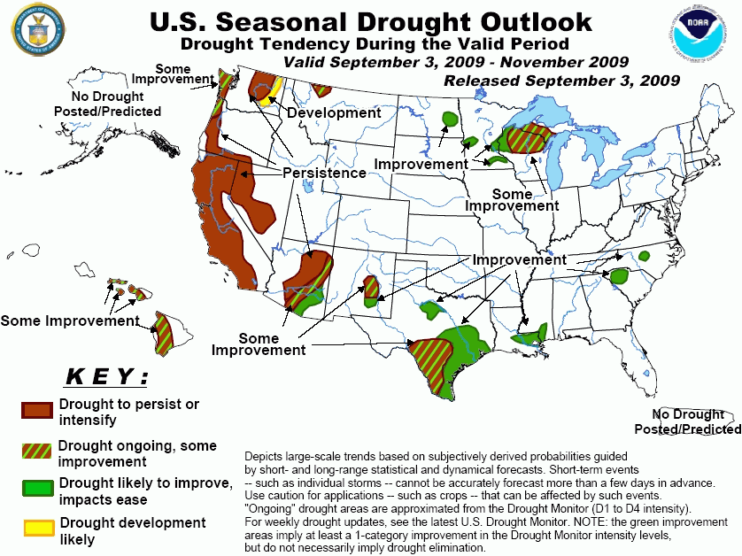
CPC Seasonal Drought Outlook issued today also looks encouraging...
0 likes
-
vbhoutex
- Storm2k Executive
- Posts: 29149
- Age: 74
- Joined: Wed Oct 09, 2002 11:31 pm
- Location: Cypress, TX
- Contact:
Re: SE TX/SW LA weather: Still Hot
Guess I better get my new rain gauge set up today!! Yard is asking for the rain, but the temps have sure been nice compared to most of the summer!!
edit on thurs.- Ok, I have found out just how dry we are here. I am now down 14" and not even a hint of moisture in the soil!! I knew it was dry, but geez!! For a fat, old man like me this will have to be a 2 day project. If we get rain moving in I still have a place I can set out the new gauge.
edit on thurs.- Ok, I have found out just how dry we are here. I am now down 14" and not even a hint of moisture in the soil!! I knew it was dry, but geez!! For a fat, old man like me this will have to be a 2 day project.
0 likes
-
srainhoutx
- S2K Supporter
- Posts: 6919
- Age: 68
- Joined: Sun Jan 14, 2007 11:34 am
- Location: Haywood County, NC
- Contact:
Re: SE TX/SW LA weather: Still Hot
Storms in Madison and Houston Counties have gone severe. Maybe Montgomery, Walker and Grimes counties can get some action as the storms move SE.
0 likes
-
Yankeegirl

- Category 5

- Posts: 3417
- Age: 50
- Joined: Sun May 23, 2004 11:59 pm
- Location: Cy-Fair, Northwest Houston
- Contact:
Re: SE TX/SW LA weather: Still Hot
NEWSFLASH..Rain all around me but not at the house. Hopefully the storms to the North will make it, but historically they fall apart after Lake Conroe.
0 likes
-
srainhoutx
- S2K Supporter
- Posts: 6919
- Age: 68
- Joined: Sun Jan 14, 2007 11:34 am
- Location: Haywood County, NC
- Contact:
Re: SE TX/SW LA weather: Still Hot
Pouring here with thunder. YIPPEE  Although we have friends in the air due to arrive at IAH around 6:30, so hoping it will move on through.
0 likes
-
jasons2k

- Storm2k Executive
- Posts: 8290
- Age: 52
- Joined: Wed Jul 06, 2005 12:32 pm
- Location: The Woodlands, TX
What the hey? Haven't run GR3 all week - haven't needed to, right??? RIGHT??
So, I get in my car to come home - and I see dark clouds and storms towards N/NW Houston. I'm thinking "where in the wortld did this come from? Maybe the seabreeze just got active a day early?!?!"
Then I get home and see storms up north with a warning and a MCD out from the SPC.
Umm, is it still Thursday? Did I miss a day somwhere? (perplexed)
Crazy.
0 likes
-
Yankeegirl
- Category 5
- Posts: 3417
- Age: 50
- Joined: Sun May 23, 2004 11:59 pm
- Location: Cy-Fair, Northwest Houston
- Contact:
Re: SE TX/SW LA weather: Still Hot
Yeah I was thinking the same thing. Just about the time the storm began building towards the area from the NW there looked like it had a counterclockwise rotation. We did receive some nice rain but had some severe weather heading our way which ended up going towards Magnolia. So the storm ended up moving SE, then S, then SW. We received rain from the eastern most part of the storm but I was expecting to receive a lot more and perhaps hail. Strange indeed. Who knows what tomorrow will bring.
0 likes
-
vbhoutex
- Storm2k Executive
- Posts: 29149
- Age: 74
- Joined: Wed Oct 09, 2002 11:31 pm
- Location: Cypress, TX
- Contact:
Re: SE TX/SW LA weather: Still Hot
vbhoutex wrote:Guess I better get my new rain gauge set up today!! Yard is asking for the rain, but the temps have sure been nice compared to most of the summer!!
edit on thurs.- Ok, I have found out just how dry we are here. I am now down 14" and not even a hint of moisture in the soil!! I knew it was dry, but geez!! For a fat, old man like me this will have to be a 2 day project.
Further edit. I set out the gauge for the severe storms moving our way and only ended up with 0.06".
0 likes
-
southerngale
- Retired Staff
- Posts: 27418
- Joined: Thu Oct 10, 2002 1:27 am
- Location: Southeast Texas (Beaumont area)
Return to “USA & Caribbean Weather”
Who is online
Users browsing this forum: No registered users and 145 guests