

TWOAT
TROPICAL WEATHER OUTLOOK
NWS TPC/NATIONAL HURRICANE CENTER MIAMI FL
200 PM EDT SAT SEP 5 2009
FOR THE NORTH ATLANTIC...CARIBBEAN SEA AND THE GULF OF MEXICO...
SHOWER AND THUNDERSTORM ACTIVITY HAS DIMINISHED IN ASSOCIATION WITH
A TROPICAL WAVE LOCATED ABOUT 1000 MILES WEST OF THE CAPE VERDE
ISLANDS. UPPER-LEVEL WINDS ARE EXPECTED TO REMAIN UNFAVORABLE...AND
SIGNIFICANT DEVELOPMENT OF THIS SYSTEM IS NOT EXPECTED AS IT MOVES
WESTWARD AT AROUND 10 MPH. THERE IS A LOW CHANCE...LESS THAN 30
PERCENT...OF THIS SYSTEM BECOMING A TROPICAL CYCLONE DURING THE
NEXT 48 HOURS.
ELSEWHERE...TROPICAL CYCLONE FORMATION IS NOT EXPECTED DURING THE
NEXT 48 HOURS.
$$
FORECASTER BRENNAN
Tropical Wave north of the Greater Antilles
Moderator: S2k Moderators
Forum rules

The posts in this forum are NOT official forecasts and should not be used as such. They are just the opinion of the poster and may or may not be backed by sound meteorological data. They are NOT endorsed by any professional institution or STORM2K. For official information, please refer to products from the National Hurricane Center and National Weather Service.
-
Gustywind

- Category 5

- Posts: 12334
- Joined: Mon Sep 03, 2007 7:29 am
- Location: Baie-Mahault, GUADELOUPE
Re: Tropical Wave in the Central Atlantic
CourierPR wrote:The last time I looked, this thread was about the wave in the central Atlantic. Naycasters, please start your own thread to talk about the supposed end to the season.
Franck here is a present for you my friend
Friendly Gutsywind

0 likes


-
Gustywind
- Category 5
- Posts: 12334
- Joined: Mon Sep 03, 2007 7:29 am
- Location: Baie-Mahault, GUADELOUPE
000
AXNT20 KNHC 060513
TWDAT
TROPICAL WEATHER DISCUSSION
NWS TPC/NATIONAL HURRICANE CENTER MIAMI FL
205 AM EDT SUN SEP 06 2009
TROPICAL WEATHER DISCUSSION FOR NORTH AMERICA...CENTRAL
AMERICA...GULF OF MEXICO...CARIBBEAN SEA...NORTHERN SECTIONS OF
SOUTH AMERICA...AND ATLANTIC OCEAN TO THE AFRICAN COAST FROM THE
EQUATOR TO 32N. THE FOLLOWING INFORMATION IS BASED ON SATELLITE
IMAGERY...METEOROLOGICAL ANALYSIS...WEATHER OBSERVATIONS...AND
RADAR.
BASED ON 0000 UTC SURFACE ANALYSIS AND SATELLITE IMAGERY THROUGH
0430 UTC.
...TROPICAL WAVES...
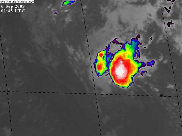
TROPICAL WAVE IS ALONG 43W S OF 21N MOVING W NEAR 12 KT. A 1012
MB LOW IS ALONG THE WAVE AXIS NEAR 14N43W. SATELLITE IMAGERY AND
SATELLITE DERIVED WINDS INDICATE LOW-LEVEL CYCLONIC FLOW IN THE
VICINITY OF THE WAVE AXIS CONCENTRATED AROUND THE LOW PRESSURE
CENTER NEAR 14N. A 2344 UTC ASCAT SCATTEROMETER PASS CONFIRMS
THE LOW-LEVEL CYCLONIC WINDS AROUND THE WAVE AXIS. THE WAVE
COINCIDES WITH A DEEP LAYER MOISTURE MAXIMUM OBSERVED TOTAL
PRECIPITABLE WATER IMAGERY. A DRY SAHARAN AIR LAYER IS TO THE W
OF THE WAVE AXIS WHICH IS LIMITING DEEP CONVECTION TO THE ITCZ
AND A SMALL CLUSTER NEAR THE LOW CENTER. ISOLATED MODERATE
CONVECTION IS FROM 8N-10N BETWEEN 41W-45W. SCATTERED
MODERATE/ISOLATED STRONG CONVECTION IS FROM 15N-17N BETWEEN
43W-44W.
$$
WALTON
AXNT20 KNHC 060513
TWDAT
TROPICAL WEATHER DISCUSSION
NWS TPC/NATIONAL HURRICANE CENTER MIAMI FL
205 AM EDT SUN SEP 06 2009
TROPICAL WEATHER DISCUSSION FOR NORTH AMERICA...CENTRAL
AMERICA...GULF OF MEXICO...CARIBBEAN SEA...NORTHERN SECTIONS OF
SOUTH AMERICA...AND ATLANTIC OCEAN TO THE AFRICAN COAST FROM THE
EQUATOR TO 32N. THE FOLLOWING INFORMATION IS BASED ON SATELLITE
IMAGERY...METEOROLOGICAL ANALYSIS...WEATHER OBSERVATIONS...AND
RADAR.
BASED ON 0000 UTC SURFACE ANALYSIS AND SATELLITE IMAGERY THROUGH
0430 UTC.
...TROPICAL WAVES...
TROPICAL WAVE IS ALONG 43W S OF 21N MOVING W NEAR 12 KT. A 1012
MB LOW IS ALONG THE WAVE AXIS NEAR 14N43W. SATELLITE IMAGERY AND
SATELLITE DERIVED WINDS INDICATE LOW-LEVEL CYCLONIC FLOW IN THE
VICINITY OF THE WAVE AXIS CONCENTRATED AROUND THE LOW PRESSURE
CENTER NEAR 14N. A 2344 UTC ASCAT SCATTEROMETER PASS CONFIRMS
THE LOW-LEVEL CYCLONIC WINDS AROUND THE WAVE AXIS. THE WAVE
COINCIDES WITH A DEEP LAYER MOISTURE MAXIMUM OBSERVED TOTAL
PRECIPITABLE WATER IMAGERY. A DRY SAHARAN AIR LAYER IS TO THE W
OF THE WAVE AXIS WHICH IS LIMITING DEEP CONVECTION TO THE ITCZ
AND A SMALL CLUSTER NEAR THE LOW CENTER. ISOLATED MODERATE
CONVECTION IS FROM 8N-10N BETWEEN 41W-45W. SCATTERED
MODERATE/ISOLATED STRONG CONVECTION IS FROM 15N-17N BETWEEN
43W-44W.
$$
WALTON
0 likes


-
gatorcane

- S2K Supporter

- Posts: 23708
- Age: 48
- Joined: Sun Mar 13, 2005 3:54 pm
- Location: Boca Raton, FL
There is wind shear screaming out of the west all the way from the GOM out east into the Central ATlantic and through all of the Caribbean. This wave in the central atlantic is going right into the teeth of that shear. At this time it has little hope.
By the way, looks more like November of December out there with those westerlies screaming across most of the Atlantic. At this rate, this season will be over early except for some areas in the far eastern atlantic that have no chance of impacting areas further west due to all of the troughiness in the Central Atlantic.
http://cimss.ssec.wisc.edu/tropic/real- ... wg8shr.GIF
0 likes

-
Gustywind
- Category 5
- Posts: 12334
- Joined: Mon Sep 03, 2007 7:29 am
- Location: Baie-Mahault, GUADELOUPE

000
AXNT20 KNHC 070559
TWDAT
TROPICAL WEATHER DISCUSSION
NWS TPC/NATIONAL HURRICANE CENTER MIAMI FL
205 AM EDT MON SEP 07 2009
TROPICAL WEATHER DISCUSSION FOR NORTH AMERICA...CENTRAL
AMERICA...GULF OF MEXICO...CARIBBEAN SEA...NORTHERN SECTIONS OF
SOUTH AMERICA...AND ATLANTIC OCEAN TO THE AFRICAN COAST FROM THE
EQUATOR TO 32N. THE FOLLOWING INFORMATION IS BASED ON SATELLITE
IMAGERY...METEOROLOGICAL ANALYSIS...WEATHER OBSERVATIONS...AND
RADAR.
BASED ON 0000 UTC SURFACE ANALYSIS AND SATELLITE IMAGERY THROUGH
0515 UTC.
...SPECIAL FEATURES...
...TROPICAL WAVES...
TROPICAL WAVE IS ALONG 49W S OF 21N MOVING W NEAR 15 KT. A 1012
MB LOW IS ALONG THE WAVE AXIS NEAR 16N. CIMSS WAVETRAK MODEL
GUIDANCE INDICATES A BROAD AREA OF 850 MB VORTICITY N OF 15N
BETWEEN 45W-55W SURROUNDING THE WAVE. SCATTERED MODERATE
CONVECTION IS 16N-18N BETWEEN 47W-50W.
...$$
HUFFMAN
0 likes
-
somethingfunny

- ChatStaff

- Posts: 3926
- Age: 37
- Joined: Thu May 31, 2007 10:30 pm
- Location: McKinney, Texas
Re:
somethingfunny wrote:Erika's remnants really haven't moved much. Any chance that these two systems collide and reorganize like TD10/TD12 did in 2005? With different results of course.
It does look like that could happen. My guess is the background situation like pressures, shear, and air quality etc are totally different.
0 likes

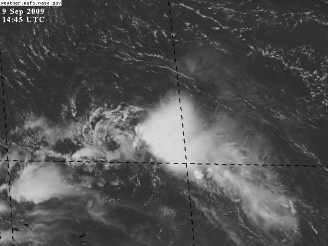
Re: Tropical Wave in the Central Atlantic
This little naked swirl(earlier) could flare up pretty good over the next 2 days as the shear is dropping in the area.
http://cimss.ssec.wisc.edu/tropic2/real ... wg8sht.GIF
http://cimss.ssec.wisc.edu/tropic2/real ... wg8sht.GIF
0 likes
-
Aric Dunn
- Category 5
- Posts: 21238
- Age: 43
- Joined: Sun Sep 19, 2004 9:58 pm
- Location: Ready for the Chase.
- Contact:
Well this swirl has been the most persistent thing i have ever seen. it has tracked nearly the entire atlantic with intermittent burst of convection then being shear by at some points 40kts of shear. but the things is still well defined. amazingly its about to move into a slightly better environment tomorrow. its a funny little thing and could eventually combine with the stalled trough over the bahamas and develop into something. there some models support for such a thing to happen but the models have a very complex environment with low popping up all over the place. be interesting to watch.
http://www.ssd.noaa.gov/goes/east/pr/loop-rgb.html
title should be changed though .. its not in the central atlantic no more.
http://www.ssd.noaa.gov/goes/east/pr/loop-rgb.html
title should be changed though .. its not in the central atlantic no more.
0 likes


Re: Tropical Wave north of the Lesser Antilles
Conditions may be better in 2 days or so when it gets into the Bahamas. The circulation, albeit a low level swirl, certainly has tenacity.
0 likes

Re: Tropical Wave north of the Lesser Antilles
it will pass just n of this buoy....look for W winds
http://www.ndbc.noaa.gov/station_page.php?station=41043
http://www.ndbc.noaa.gov/station_page.php?station=41043
0 likes
Who is online
Users browsing this forum: No registered users and 80 guests