

Given the upper-level environment, development is not likely, not sure what people are seeing when they mention the possibility of development. I don't see it.
Actually looks more like a winter-time setup along the Eastern Seaboard as that low pressure area will head of the NNE and get buried by the westerlies over the next couple of days.
The best place to look for tropical development for the forseeable future is in the far Eastern Atlantic where we have a possible named stormed developing. But the only land it would impact at this time might be Spain or Portugal (as Derek as already noted) as it recurves very quickly.
Usually in November and December we look out into the Far Eastern Atlantic for systems that develop and recurve very quickly, but looks like it is already happening because basically the entire Altantic Basin from the GOM, Caribbean, and Central Atlantic is unfavorable for development due to strong westerly shear, like what you would see in those months.
EAST COAST DEVELOPMENT
Moderator: S2k Moderators
Forum rules

The posts in this forum are NOT official forecasts and should not be used as such. They are just the opinion of the poster and may or may not be backed by sound meteorological data. They are NOT endorsed by any professional institution or STORM2K. For official information, please refer to products from the National Hurricane Center and National Weather Service.
-
somethingfunny

- ChatStaff

- Posts: 3926
- Age: 37
- Joined: Thu May 31, 2007 10:30 pm
- Location: McKinney, Texas
Re: EAST COAST DEVELOPMENT
vbhoutex wrote:We are get some rain now. Wow You know when they put up a Interest It would go to the other board. Even if there ia not a closed center. And this has a closed center.
So why is it not moved to the other board?
This will not go to the Active Storms forum until it is declared an Invest or TC by the NHC. That is how we determine which forum it belongs in.
There is always the USA Weather forum
0 likes
-
vbhoutex

- Storm2k Executive

- Posts: 29139
- Age: 74
- Joined: Wed Oct 09, 2002 11:31 pm
- Location: Cypress, TX
- Contact:
Re: EAST COAST DEVELOPMENT
somethingfunny wrote:vbhoutex wrote:We are get some rain now. Wow You know when they put up a Interest It would go to the other board. Even if there ia not a closed center. And this has a closed center.
So why is it not moved to the other board?
This will not go to the Active Storms forum until it is declared an Invest or TC by the NHC. That is how we determine which forum it belongs in.
There is always the USA Weather forumNorth Carolina...actually, everything outside of Texas, Louisiana, and Florida....is very underrepresented in there. Start up a thread!
That would be my next suggestion if you feel the need for a discussion area for the Carolina's/mid-Atlantic, or a similar area start a thread in the USA Weather forum. It is not meant to be a tropical forum but a catch all weather forum.
Back to the weather there now. Until the low pressure trough turns into a more concentrated CC and becomes warm core for sure this system is going to be declared an invest imo. I've been proved wrong before and maybe if it sits around long enough this could happen, but with the incoming cut-off low to its NW swinging along a front and trough with it I suspect this will start moving NNE soon, if it hasn't and start heading up the Eastern Seaboard as a rain maker. My thoughts are based on conjecture only at this point as I have not looked at any synoptics, radar, or models lately.
0 likes
Re: EAST COAST DEVELOPMENT
The posts in this forum are NOT official forecast and should not be used as such. They are just the opinion of the poster and may or may not be backed by sound meteorological data. They are NOT endorsed by any professional institution or storm2k.org. For official information, please refer to the NHC and NWS products.
gatorcane wrote:Given the upper-level environment, development is not likely, not sure what people are seeing when they mention the possibility of development. I don't see it.
Actually looks more like a winter-time setup along the Eastern Seaboard as that low pressure area will head of the NNE and get buried by the westerlies over the next couple of days.
I am not seeing the shortwave strength that a classic EC wintertime setup would bring. Also this is not a fast mover, everything that I have seen from the models is that the steering currents are slow. Normally a wintertime setup and this would be gone in a day. The surface feature has been hanging around for over a day and will probably hang around for a day or two more. Should be fun to watch. The visible lower level feature is actually getting pretty close to the convection now. And Frying Pan Shoals is starting back down again.

0 likes

-
hurricanedude

- Military Member

- Posts: 1856
- Joined: Tue Oct 08, 2002 9:54 am
- Location: Virginia Beach, Virginia
- Contact:
Re: EAST COAST DEVELOPMENT
oh yeah..I spent just short of a year on the Miss Coast after Katrina, was great to help...people were so genuinely appreciatable.
0 likes

-
Aric Dunn
- Category 5

- Posts: 21238
- Age: 43
- Joined: Sun Sep 19, 2004 9:58 pm
- Location: Ready for the Chase.
- Contact:
no joke.. everything i can see makes this a depression..
sometimes I wonder about the NHC
i know the upper winds are "not favorable" for significant development but when something meets the criteria .. it meets the criteria even if its for only 24 hours..
and considering the models want to keep the feature around for a little while.. cant seem to figure it out..
oh well..
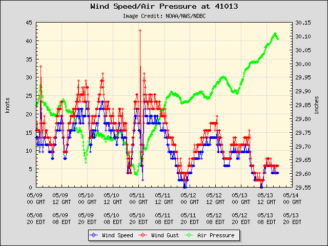
the buoy just off shore sitting right near the center..
http://www.ndbc.noaa.gov/station_page.php?station=41013
sometimes I wonder about the NHC
i know the upper winds are "not favorable" for significant development but when something meets the criteria .. it meets the criteria even if its for only 24 hours..
and considering the models want to keep the feature around for a little while.. cant seem to figure it out..
oh well..
the buoy just off shore sitting right near the center..
http://www.ndbc.noaa.gov/station_page.php?station=41013
0 likes
Re:
Is there evidence of a closed circulation? Any reports of west winds where you would expect if this was developing? No doubt this is a system casuing inclement weather....but structure-wise, is this a tropical low at the surface with a closed off circulation? No question that strong low pressures can develop in the ocean....some nor'easters have hurricane force winds and pressure readings, but they aren't tropical in structure.
Aric Dunn wrote:no joke.. everything i can see makes this a depression..
sometimes I wonder about the NHC
i know the upper winds are "not favorable" for significant development but when something meets the criteria .. it meets the criteria even if its for only 24 hours..
and considering the models want to keep the feature around for a little while.. cant seem to figure it out..
oh well..
the buoy just off shore sitting right near the center..
http://www.ndbc.noaa.gov/station_page.php?station=41013
Last edited by jinftl on Mon Sep 07, 2009 3:00 pm, edited 2 times in total.
0 likes
-
Aric Dunn
- Category 5
- Posts: 21238
- Age: 43
- Joined: Sun Sep 19, 2004 9:58 pm
- Location: Ready for the Chase.
- Contact:
Re: Re:
jinftl wrote:Is there evidence of a closed circulation? Any reports of west winds where you would expect if this was developing? No doubt this is a system casuing inclement weather....but structure-wise, is this a tropical low at the surface with a closed off circulation?Aric Dunn wrote:no joke.. everything i can see makes this a depression..
sometimes I wonder about the NHC
i know the upper winds are "not favorable" for significant development but when something meets the criteria .. it meets the criteria even if its for only 24 hours..
and considering the models want to keep the feature around for a little while.. cant seem to figure it out..
oh well..
the buoy just off shore sitting right near the center..
http://www.ndbc.noaa.gov/station_page.php?station=41013
I have found NW winds but we should have a report from that part of the system in the next hour or so as it passes a nearby buoy..
all other data suggest a closed circ and its tropical with temp and dew point profiles from the stations over land and offshore buoys showing pretty good evidence of it.. structure wise .. I have seen worse..
0 likes
Re: Re:
Are you surprised this isn't an invest?
Aric Dunn wrote:jinftl wrote:Is there evidence of a closed circulation? Any reports of west winds where you would expect if this was developing? No doubt this is a system casuing inclement weather....but structure-wise, is this a tropical low at the surface with a closed off circulation?Aric Dunn wrote:no joke.. everything i can see makes this a depression..
sometimes I wonder about the NHC
i know the upper winds are "not favorable" for significant development but when something meets the criteria .. it meets the criteria even if its for only 24 hours..
and considering the models want to keep the feature around for a little while.. cant seem to figure it out..
oh well..
the buoy just off shore sitting right near the center..
http://www.ndbc.noaa.gov/station_page.php?station=41013
I have found NW winds but we should have a report from that part of the system in the next hour or so as it passes a nearby buoy..
all other data suggest a closed circ and its tropical with temp and dew point profiles from the stations over land and offshore buoys showing pretty good evidence of it.. structure wise .. I have seen worse..
0 likes
-
Aric Dunn
- Category 5
- Posts: 21238
- Age: 43
- Joined: Sun Sep 19, 2004 9:58 pm
- Location: Ready for the Chase.
- Contact:
well as soon as the website updates the buoy i just posted dropped from 1010mb to 1008 in 1 hour and winds a have dropped down to around 10 kts .. which means the center is right over it or very near..
and yeah surprised its not a depression right now..
http://www.ndbc.noaa.gov/station_page.php?station=41013
with a pressure of 1008 and background pressure of 1014 to 1016 .. thats pretty decent..
doppler velocities at about 5000 ft are showing some 43kt winds which after some reduction would bring it down to 30kts or so ..
0 likes
I guess because it will be gone before they can fly into it. I'm near cape lookout, and there is not really anything happening here. Moderate steady rain all day, but not even breezy, just a little out of NE less than 10-15. No thunder. Rain does not even :feel: tropical, just a steady rain. If it is doing anything, it must be very small and I don't think it would be even be tropical at this point. Maybe sub-trop system....... I dont know.
0 likes
-
Aric Dunn
- Category 5
- Posts: 21238
- Age: 43
- Joined: Sun Sep 19, 2004 9:58 pm
- Location: Ready for the Chase.
- Contact:
Re:
capepoint wrote:I guess because it will be gone before they can fly into it. I'm near cape lookout, and there is not really anything happening here. Moderate steady rain all day, but not even breezy, just a little out of NE less than 10-15. No thunder. Rain does not even :feel: tropical, just a steady rain. If it is doing anything, it must be very small and I don't think it would be even be tropical at this point. Maybe sub-trop system....... I dont know.
all the winds are on the other side of the system .. and near the center..
you wont get much stronger winds than that unless it comes in west of you ..
Last edited by Aric Dunn on Mon Sep 07, 2009 3:37 pm, edited 1 time in total.
0 likes
Re: EAST COAST DEVELOPMENT
This system is just a footnote on Dr. Jeff Master's update today.....being a footnote this close to shore on an update that focuses 90% on Invest 96L says alot.
Per Dr. Jeff Masters:
An area of concentrated thunderstorms has developed off the North Carolina coast in association with the remains of an old cold front. This system is under about 20 - 30 knots of shear, and is not tropical. However, it will bring heavy rain to eastern North Carolina today and Tuesday, as the storm slides north-northeastward along the coast.
0 likes
Re: Re:
Aric Dunn wrote:capepoint wrote:I guess because it will be gone before they can fly into it. I'm near cape lookout, and there is not really anything happening here. Moderate steady rain all day, but not even breezy, just a little out of NE less than 10-15. No thunder. Rain does not even :feel: tropical, just a steady rain. If it is doing anything, it must be very small and I don't think it would be even be tropical at this point. Maybe sub-trop system....... I dont know.
all the winds are on the other side of the system .. and near the center..
you wont get much stronger winds than that unless it comes in west of you ..
Yeah I know..just letting yall know that I'm here and this does not look or feel tropical. I have been thru and near a lot of tropical systems here, and this just aint one. It's more like a very weak early noreaster.
0 likes
-
Aric Dunn
- Category 5
- Posts: 21238
- Age: 43
- Joined: Sun Sep 19, 2004 9:58 pm
- Location: Ready for the Chase.
- Contact:
Re: EAST COAST DEVELOPMENT
jinftl wrote:This system is just a footnote on Dr. Jeff Master's update today.....being a footnote this close to shore on an update that focuses 90% on Invest 96L says alot.
Per Dr. Jeff Masters:
An area of concentrated thunderstorms has developed off the North Carolina coast in association with the remains of an old cold front. This system is under about 20 - 30 knots of shear, and is not tropical. However, it will bring heavy rain to eastern North Carolina today and Tuesday, as the storm slides north-northeastward along the coast.
not sure where the non tropical is coming from .. temp and dew point profiles are good..
0 likes
-
Aric Dunn
- Category 5
- Posts: 21238
- Age: 43
- Joined: Sun Sep 19, 2004 9:58 pm
- Location: Ready for the Chase.
- Contact:
Re: Re:
capepoint wrote:Aric Dunn wrote:capepoint wrote:I guess because it will be gone before they can fly into it. I'm near cape lookout, and there is not really anything happening here. Moderate steady rain all day, but not even breezy, just a little out of NE less than 10-15. No thunder. Rain does not even :feel: tropical, just a steady rain. If it is doing anything, it must be very small and I don't think it would be even be tropical at this point. Maybe sub-trop system....... I dont know.
all the winds are on the other side of the system .. and near the center..
you wont get much stronger winds than that unless it comes in west of you ..
Yeah I know..just letting yall know that I'm here and this does not look or feel tropical. I have been thru and near a lot of tropical systems here, and this just aint one. It's more like a very weak early noreaster.
except you have temps in the 80's and dew points in the 70's... no nor easter hehe
0 likes
Re: EAST COAST DEVELOPMENT
Aric Dunn wrote:Except you have temps in the 80's and dew points in the 70's... no nor easter hehe
And Cape Lookout is reporting 23 kt winds http://www.ndbc.noaa.gov/station_page.php?station=clkn7
Code: Select all
Wind Direction (WDIR):   ENE ( 70 deg true )
Wind Speed (WSPD):   23 kts
Wind Gust (GST):   25 kts
Atmospheric Pressure (PRES):   29.98 in
Pressure Tendency (PTDY):   -0.03 in ( Falling )
Air Temperature (ATMP):   72.5 °F
0 likes
-
djones65
- Category 1

- Posts: 264
- Age: 60
- Joined: Mon Jun 20, 2005 12:05 am
- Location: Ocean Springs, MS
I am really surprised the NHC isn't discussing this feature more than they are. I agree completely with Aric that this system is likely a tropical depression. The fact it was not declared an invest is even more surprising given its location so close to the coast of North Carolina. I see a low level circulation partially exposed on the south edge of the concentrated convection. Upper level winds are unfavorable for significant development, but it wouldn't take much strengthening to produce tropical storm force winds in the convection northeast of the center.
Does anyone else remember invest 98L in July? I don't see how that system was declared an invest and this disturbance which is much better organized was not.
I agree with Aric that this system meets criteria of a tropical cyclone.
Does anyone else remember invest 98L in July? I don't see how that system was declared an invest and this disturbance which is much better organized was not.
I agree with Aric that this system meets criteria of a tropical cyclone.
0 likes
Who is online
Users browsing this forum: wwizard and 62 guests