
I think Fred got mad with those calling for "season cancelled" lol
Moderator: S2k Moderators


HURAKAN wrote:cycloneye wrote:HURAKAN wrote:Discussion:
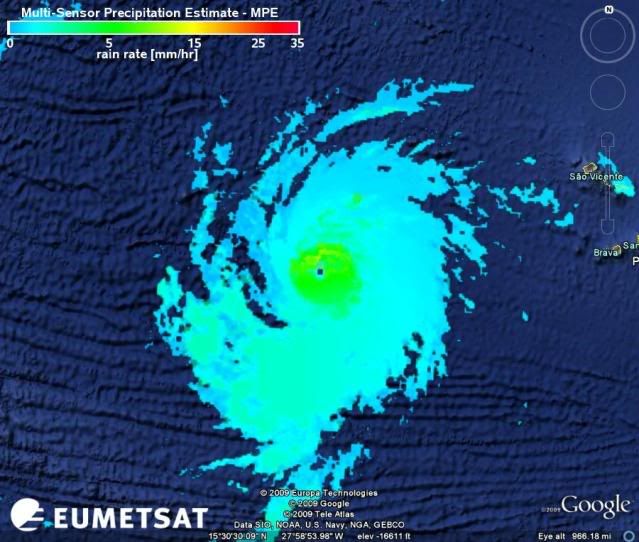
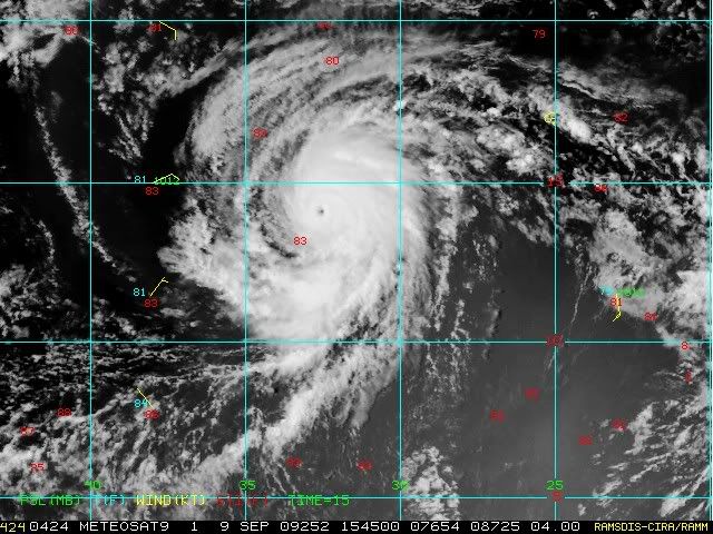
IT IS QUITE UNUSUAL TO HAVE SUCH A POWERFUL SYSTEM SO FAR EAST IN
THE BASIN AND FRED IS ONLY THE THIRD MAJOR HURRICANE NOTED EAST OF
35W IN THE TROPICAL ATLANTIC OCEAN...AND THE STRONGEST HURRICANE SO
FAR SOUTH AND EAST IN OUR DATA RECORD. THIS TYPE OF SYSTEM...
HOWEVER...WOULD HAVE BEEN VERY DIFFICULT TO ACCURATELY OBSERVE
BEFORE SATELLITE PICTURES BEGAN IN THE 1960S.
HURAKAN,do you know which were the other two majors?
Isaac, 2000Code: Select all
Date: 21 SEP-4 OCT 2000
Hurricane ISAAC
ADV  LAT   LON       TIME     WIND  PR  STAT
  1  11.50  -23.00 09/21/12Z   30  1008 TROPICAL DEPRESSION
  2  11.90  -24.50 09/21/18Z   30  1008 TROPICAL DEPRESSION
  3  12.30  -25.90 09/22/00Z   35  1005 TROPICAL STORM
  4  12.70  -27.20 09/22/06Z   40  1001 TROPICAL STORM
  5  13.10  -28.70 09/22/12Z   45  1000 TROPICAL STORM
  6  13.50  -30.10 09/22/18Z   45  1000 TROPICAL STORM
  7  13.70  -31.20 09/23/00Z   50   997 TROPICAL STORM
  8  13.90  -32.30 09/23/06Z   55   994 TROPICAL STORM
  9  14.30  -33.20 09/23/12Z   70   984 HURRICANE-1
 10  14.60  -34.20 09/23/18Z   85   973 HURRICANE-2
 11  14.90  -35.00 09/24/00Z  105   960 HURRICANE-3
Frances, 1980Code: Select all
Date: 6-21 SEP 1980
Hurricane FRANCES
ADV  LAT   LON       TIME     WIND  PR  STAT
  1  12.50  -19.00 09/06/00Z   25  1010 TROPICAL DEPRESSION
  2  12.50  -20.00 09/06/06Z   25  1009 TROPICAL DEPRESSION
  3  12.60  -21.00 09/06/12Z   30  1008 TROPICAL DEPRESSION
  4  12.70  -21.80 09/06/18Z   35  1005 TROPICAL STORM
  5  12.80  -22.50 09/07/00Z   40  1002 TROPICAL STORM
  6  12.90  -23.20 09/07/06Z   45   998 TROPICAL STORM
  7  13.00  -24.00 09/07/12Z   55   994 TROPICAL STORM
  8  13.00  -24.80 09/07/18Z   60   990 TROPICAL STORM
  9  13.00  -25.60 09/08/00Z   65   986 HURRICANE-1
 10  13.00  -26.80 09/08/06Z   70   978 HURRICANE-1
 11  12.90  -28.00 09/08/12Z   80   970 HURRICANE-1
 12  12.80  -29.00 09/08/18Z   90   965 HURRICANE-2
 13  12.80  -29.80 09/09/00Z  100   960 HURRICANE-3


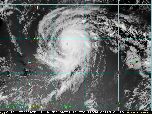
wxman57 wrote:A nice eye makes it easier to gauge movement. Using software in GARP, I"m measuring the following:
3hr: 320 deg. at 13 kts
6hr: 310 deg. at 11.5 kts
Appears to be accelerating to the NW now.
ozonepete wrote:wxman57 wrote:A nice eye makes it easier to gauge movement. Using software in GARP, I"m measuring the following:
3hr: 320 deg. at 13 kts
6hr: 310 deg. at 11.5 kts
Appears to be accelerating to the NW now.
Interesting. The models had forecast a slowing down.


Shewtinstar wrote:Hi guys, I have no doubt that this is the wrong forum, but I don't know where else to put it (dang newbies). Anyway, I see a swirl with minor confection NE of the Caribbean. Does anyone else see it or is it my old age and wishful thinking?
Users browsing this forum: No registered users and 6 guests


