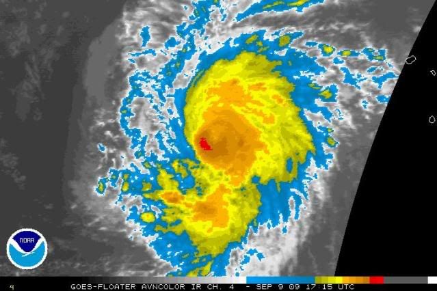
ATL: TROPICAL LOW ex-FRED (ex-07L)

Moderator: S2k Moderators

Message
Author
ozonepete
Professional-Met
Professional-Met
Posts: 4743
Joined: Mon Sep 07, 2009 3:23 pm
Location: From Ozone Park, NYC / Now in Brooklyn, NY

Re: ATL: HURRICANE FRED (07L)

#461 Postby ozonepete » Wed Sep 09, 2009 12:24 pm

wxman57 wrote:
ozonepete wrote:
wxman57 wrote:A nice eye makes it easier to gauge movement. Using software in GARP, I"m measuring the following:

3hr: 320 deg. at 13 kts
6hr: 310 deg. at 11.5 kts

Appears to be accelerating to the NW now.


Interesting. The models had forecast a slowing down.


It'll slow down. This acceleration is only temporary. I'm still measuring about 320 deg. at 13 kts for a 3hr movement.


Ok, wxman57, keep us posted please. :) One would normally expect it to slow down as it enters the recurve, and of course thereafter it's going to be interesting to see if it stalls out or not.
0 likes   

User avatar
Buck
S2K Supporter
S2K Supporter
Posts: 1173
Joined: Fri Sep 10, 2004 12:04 pm
Location: Atlanta, GA

#462 Postby Buck » Wed Sep 09, 2009 12:32 pm

Wow, Fred certainly didn't waste any time strengthening!
0 likes   

CrazyC83
Professional-Met
Professional-Met
Posts: 34002
Joined: Tue Mar 07, 2006 11:57 pm
Location: Deep South, for the first time!

Re: ATL: HURRICANE FRED (07L)

#463 Postby CrazyC83 » Wed Sep 09, 2009 12:33 pm

kurtpage wrote:Anybody think this can get to a Cat-4???


It might be a Cat 4 now...
0 likes   

User avatar
Bocadude85
Category 5
Category 5
Posts: 2991
Age: 38
Joined: Mon Apr 18, 2005 2:20 pm
Location: Honolulu,Hi

Re: ATL: HURRICANE FRED (07L)

#464 Postby Bocadude85 » Wed Sep 09, 2009 12:44 pm

CrazyC83 wrote:
kurtpage wrote:Anybody think this can get to a Cat-4???


It might be a Cat 4 now...


Fred sure is looking good... wouldnt be to surprised if this was bumped up to 135mph at 5pm
0 likes   

User avatar
cycloneye
Admin
Admin
Posts: 145313
Age: 68
Joined: Thu Oct 10, 2002 10:54 am
Location: San Juan, Puerto Rico

Re: ATL: HURRICANE FRED (07L) - Computer Models

#465 Postby cycloneye » Wed Sep 09, 2009 12:47 pm

12z CMC bends to the west after going north.

http://moe.met.fsu.edu/cgi-bin/cmctc2.c ... =Animation
0 likes   

Sanibel
Category 5
Category 5
Posts: 10375
Joined: Mon Aug 30, 2004 11:06 pm
Location: Offshore SW Florida

Re: ATL: HURRICANE FRED (07L)

#466 Postby Sanibel » Wed Sep 09, 2009 12:48 pm

Of course it has to be mentioned that this only makes you wonder what other parts of the basin are now capable of if some kind of teleconnection happens.


You would think that pinhole eye would have to be at least category 4.
0 likes   

User avatar
HURAKAN
Professional-Met
Professional-Met
Posts: 46086
Age: 38
Joined: Thu May 20, 2004 4:34 pm
Location: Key West, FL
Contact:

#467 Postby HURAKAN » Wed Sep 09, 2009 12:50 pm

Image

Hurricane Fred
0 likes   

CrazyC83
Professional-Met
Professional-Met
Posts: 34002
Joined: Tue Mar 07, 2006 11:57 pm
Location: Deep South, for the first time!

#468 Postby CrazyC83 » Wed Sep 09, 2009 12:53 pm

Given its small size, an ERC may not be that far away...
0 likes   

User avatar
cycloneye
Admin
Admin
Posts: 145313
Age: 68
Joined: Thu Oct 10, 2002 10:54 am
Location: San Juan, Puerto Rico

Re: ATL: HURRICANE FRED (07L)

#469 Postby cycloneye » Wed Sep 09, 2009 12:53 pm

ADVANCED DVORAK TECHNIQUE
ADT-Version 7.2.3
Tropical Cyclone Intensity Algorithm

----- Current Analysis -----
Date : 09 SEP 2009 Time : 171500 UTC
Lat : 14:19:41 N Lon : 32:35:43 W


CI# /Pressure/ Vmax
6.1 / 948.4mb/117.4kt


Final T# Adj T# Raw T#
(3hr avg)
6.0 5.6 5.6

Latitude bias adjustment to MSLP : +3.0mb

Estimated radius of max. wind based on IR :N/A km

Center Temp : -29.2C Cloud Region Temp : -62.8C

Scene Type : EYE

Positioning Method : SPIRAL ANALYSIS

Ocean Basin : ATLANTIC
Dvorak CI > MSLP Conversion Used : ATLANTIC

Tno/CI Rules : Constraint Limits : NO LIMIT
Weakening Flag : ON
Rapid Dissipation Flag : OFF
0 likes   

User avatar
HURAKAN
Professional-Met
Professional-Met
Posts: 46086
Age: 38
Joined: Thu May 20, 2004 4:34 pm
Location: Key West, FL
Contact:

#470 Postby HURAKAN » Wed Sep 09, 2009 1:05 pm

Image

Looking excellent
0 likes   

User avatar
cycloneye
Admin
Admin
Posts: 145313
Age: 68
Joined: Thu Oct 10, 2002 10:54 am
Location: San Juan, Puerto Rico

Re: ATL: HURRICANE FRED (07L)

#471 Postby cycloneye » Wed Sep 09, 2009 1:05 pm

Impressive eye of Fred on image from this morning.

Image
0 likes   

User avatar
micktooth
S2K Supporter
S2K Supporter
Posts: 391
Joined: Mon Jul 11, 2005 3:47 pm
Location: PreK:New Orleans,PostK:Colorado

Re: ATL: HURRICANE FRED (07L)

#472 Postby micktooth » Wed Sep 09, 2009 1:07 pm

Don't know if anyone posted this yet, I'm glad Fred is a fish!

Image
0 likes   

User avatar
cycloneye
Admin
Admin
Posts: 145313
Age: 68
Joined: Thu Oct 10, 2002 10:54 am
Location: San Juan, Puerto Rico

Re: ATL: HURRICANE FRED (07L) - Computer Models

#473 Postby cycloneye » Wed Sep 09, 2009 1:08 pm

12z UKMET also bends to the west.

GLOBAL MODEL DATA TIME 12UTC 09.09.2009

HURRICANE FRED ANALYSED POSITION : 13.7N 31.9W

ATCF IDENTIFIER : AL072009

VERIFYING TIME POSITION STRENGTH TENDENCY
-------------- -------- -------- --------
12UTC 09.09.2009 13.7N 31.9W MODERATE
00UTC 10.09.2009 14.9N 33.9W STRONG INTENSIFYING SLIGHTLY
12UTC 10.09.2009 15.7N 35.2W STRONG LITTLE CHANGE
00UTC 11.09.2009 16.3N 36.2W MODERATE WEAKENING SLIGHTLY
12UTC 11.09.2009 16.6N 36.3W MODERATE WEAKENING SLIGHTLY
00UTC 12.09.2009 16.3N 36.3W MODERATE WEAKENING SLIGHTLY
12UTC 12.09.2009 16.3N 36.5W WEAK WEAKENING SLIGHTLY
00UTC 13.09.2009 15.6N 36.2W WEAK LITTLE CHANGE
12UTC 13.09.2009 16.0N 36.8W WEAK WEAKENING SLIGHTLY
00UTC 14.09.2009 16.0N 37.5W WEAK LITTLE CHANGE
12UTC 14.09.2009 16.7N 39.4W WEAK LITTLE CHANGE
00UTC 15.09.2009 16.7N 41.5W WEAK LITTLE CHANGE
12UTC 15.09.2009 16.9N 43.6W WEAK LITTLE CHANGE
0 likes   

User avatar
HURAKAN
Professional-Met
Professional-Met
Posts: 46086
Age: 38
Joined: Thu May 20, 2004 4:34 pm
Location: Key West, FL
Contact:

#474 Postby HURAKAN » Wed Sep 09, 2009 1:11 pm

Image

The eye is closing
0 likes   

CrazyC83
Professional-Met
Professional-Met
Posts: 34002
Joined: Tue Mar 07, 2006 11:57 pm
Location: Deep South, for the first time!

#475 Postby CrazyC83 » Wed Sep 09, 2009 1:16 pm

Looks to have peaked, at least for now. Maybe an ERC getting underway?
0 likes   

User avatar
cycloneye
Admin
Admin
Posts: 145313
Age: 68
Joined: Thu Oct 10, 2002 10:54 am
Location: San Juan, Puerto Rico

Re: ATL: HURRICANE FRED (07L)

#476 Postby cycloneye » Wed Sep 09, 2009 1:17 pm

Eye still there at visible image.

Image
0 likes   

User avatar
HURAKAN
Professional-Met
Professional-Met
Posts: 46086
Age: 38
Joined: Thu May 20, 2004 4:34 pm
Location: Key West, FL
Contact:

#477 Postby HURAKAN » Wed Sep 09, 2009 1:37 pm

09/1800 UTC 14.4N 32.9W T5.0/5.5 FRED

Looks like Fred has peaked
0 likes   

User avatar
brunota2003
S2K Supporter
S2K Supporter
Posts: 9476
Age: 34
Joined: Sat Jul 30, 2005 9:56 pm
Location: Stanton, KY...formerly Havelock, NC
Contact:

#478 Postby brunota2003 » Wed Sep 09, 2009 1:39 pm

If it can pop that eye back out, the T numbers will shoot back up again...but as far as it's true intensity? We will never know.
0 likes   

User avatar
cycloneye
Admin
Admin
Posts: 145313
Age: 68
Joined: Thu Oct 10, 2002 10:54 am
Location: San Juan, Puerto Rico

Re: ATL: HURRICANE FRED (07L)

#479 Postby cycloneye » Wed Sep 09, 2009 1:42 pm

18 UTC Best Track

It has peaked as winds are down to 100kts.

AL, 07, 2009090918, , BEST, 0, 144N, 329W, 100, 960, HU

ftp://ftp.tpc.ncep.noaa.gov/atcf/tcweb/ ... 009.invest
0 likes   

CrazyC83
Professional-Met
Professional-Met
Posts: 34002
Joined: Tue Mar 07, 2006 11:57 pm
Location: Deep South, for the first time!

#480 Postby CrazyC83 » Wed Sep 09, 2009 1:44 pm

My guess is that it peaked at 1500Z when the eye was best defined.
0 likes   


Return to “2009”

Who is online

Users browsing this forum: No registered users and 5 guests