
New Orleans AFD
AREA FORECAST DISCUSSION
NATIONAL WEATHER SERVICE NEW ORLEANS LA
837 AM CDT THU SEP 10 2009
.UPDATE...
...SOUNDING DISCUSSION...
NO PROBLEMS WITH THE FLIGHT THIS MORNING. ANOTHER VERY SATURATED
SOUNDING THIS MORNING WITH A PW OF 2.21 INCHES AS A LARGE AREA OF
TROPICAL MOISTURE CONTINUES TO MOVE ONSHORE. WITH PLENTY OF
MOISTURE IN PLACE...ENOUGH LIFT AND A VERY SLOW MOVING STORM
MOTION OF 2 KNOTS...HEAVY SLOW MOVING SHOWERS AND STORMS WILL HAVE
THE POTENTIAL TO PRODUCE LOCALIZED FLOODING. LIGHT SOUTHEASTERLY
WINDS ARE PREDOMINATE IN THE LOWER LEVELS.
&&
.PREV DISCUSSION... /ISSUED 356 AM CDT THU SEP 10 2009/
SYNOPSIS...
SOUTHEASTERLY LOW LEVEL FLOW IS BRINGING SHOWERS AND A THUNDERSTORM
OR TWO TO COASTAL AREAS EARLY THIS MORNING. SEEING QUITE A BIT OF
BLOOMING OF PRECIPITATION OVER THE GULF IN THE LAST 15-30 MINUTES.
STILL ON THE LOOKOUT FOR FOG...BUT NO OBS SITES HAVING SIGNIFICANT
PROBLEMS YET. TEMPS IN THE LOWER AND MIDDLE 70S...WITH DEW POINTS
LAGGING THOSE LEVELS BY A COUPLE OF DEGREES.
SHORT TERM...
FORECAST IN ONE WORD...WET.
PRECIPITABLE WATER VALUES WERE ALREADY IN EXCESS OF 2 INCHES ON
THE 00Z LIX SOUNDING. THESE VALUES ARE ONLY EXPECTED TO
INCREASE OVER THE NEXT COUPLE OF DAYS. ALL MODELS INDICATE A WARM
CORE CIRCULATION TO DEVELOP OVER THE WESTERN GULF OVER THE NEXT 48
HOURS AND MOVE TOWARD THE AREA. 00Z/06Z NAM IS THE MOST AGGRESSIVE
IN DEVELOPING A SURFACE CENTER...WITH IT LOCATED JUST OFF THE
TEXAS COAST NEAR HOUSTON AT MIDDAY SATURDAY...BRINGING IT INLAND
NEAR BEAUMONT TEXAS SATURDAY EVENING. GFS IS CONSIDERABLY
WEAKER...BUT STILL THERE. IN EITHER CASE INCREASING SOUTHEAST TO
SOUTH FLOW WILL CONTINUE TO PUMP MOISTURE ONSHORE THROUGH SUNDAY
WITH PRECIPITABLE WATER VALUES NEAR 2.3 INCHES BY SATURDAY.
00Z GFS SOLUTION APPEARS TO HAVE SOME FEEDBACK PROBLEMS OVER THE
NEXT 36 HOURS...AS NOTED BY THE 5 INCH QPF BULLSEYE NEAR MCCOMB
TONIGHT...AND DEFINITE POPS ARE JUST A LITTLE TOO HIGH. WILL GO
WITH LIKELY POPS TODAY FOR ALL EXCEPT THE MISSISSIPPI COAST...WHICH
HAS NOT HAD THE DRIER AIR SCOURED OUT QUITE YET. THIS IS BELOW MAV
VALUES BUT ABOVE MET. MOST PRECIPITATION WILL OCCUR DURING THE
DIURNAL HEATING FAVORED HOURS TODAY AND FRIDAY...WITH MOST
CONVECTION DONE BY 02Z. WILL ONLY GO LIKELY ON SATURDAY FOR
NOW...AS TIMING...STRENGTH AND LOCATION OF SYSTEM STILL SOMEWHAT
IN QUESTION. TEMPERATURES WILL GENERALLY BE ABOVE MAV GUIDANCE BUT
BELOW MET GUIDANCE THROUGH SATURDAY. 35
LONG TERM...
WILL TREND EXTENDED PORTION OF FORECAST TOWARD GFS SOLUTION...WHICH
WILL STILL HAVE RAIN IN THE AREA SUNDAY AND MONDAY BEFORE DRIER
AIR TRIES TO WORK INTO THE AREA. WILL GO WITH LIKELY POPS SUNDAY
AND HIGH CHANCE MONDAY BEFORE TRIMMING THEM BACK FOR MIDWEEK.
ONE THING TO NOTE WILL BE POTENTIAL FOR FLOODING AT SOME POINT
OVER THE NEXT WEEK. WITH THE HIGH PRECIPITABLE WATER
VALUES...EXPECT FAIRLY EFFICIENT RAIN PROCESSES MOST DAYS. WHILE
INDIVIDUAL DAYS MAY ONLY SEE 1 TO 2 INCHES OF RAIN...THERE IS THE
POTENTIAL FOR THIS TO HAPPEN FOR ROUGHLY 3 DAYS IN A ROW. NOTED
THAT HPC 5 DAY QPF FROM YESTERDAY AFTERNOON COVERED MOST OF THE
AREA WITH 3 INCH TOTALS...AND WOULD NOT BE SURPRISED TO SEE THIS
INCREASE LATER THIS MORNING. WILL ADDRESS IN THE MORNING HWO AS A
STARTER. 35
Possible NW Gulf Development Late This Week?
Moderator: S2k Moderators
Forum rules

The posts in this forum are NOT official forecasts and should not be used as such. They are just the opinion of the poster and may or may not be backed by sound meteorological data. They are NOT endorsed by any professional institution or STORM2K. For official information, please refer to products from the National Hurricane Center and National Weather Service.
-
Portastorm

- Storm2k Moderator

- Posts: 9955
- Age: 63
- Joined: Fri Jul 11, 2003 9:16 am
- Location: Round Rock, TX
- Contact:
Re: Possible NW Gulf Development Late This Week?
lrak wrote:cycloneye wrote:Irak,I check a lot this webcam at the Corpus Christi bayfront and I like the change from sunny and hot to cloudy and rainy there.Lets see if the area gets the much needed rain.
http://www.cctexas.com/webcam/
I look at that one also for wind conditions when we hit the bay.
The website below has a bunch of webcams on the top left of the page. A few aren't working...grrr.
http://www.thirdcoastsurf.com/
I hope we don't get more tropical rains than we NEED
Time for my daily whine: We need the rain! Send whatever you don't use up here. Once again the radar shows the bulk of the heavy rains at I-10 and south. We're getting clouds and humidity here in Austin.
0 likes
-
HURAKAN

- Professional-Met

- Posts: 46084
- Age: 39
- Joined: Thu May 20, 2004 4:34 pm
- Location: Key West, FL
- Contact:
Re: Possible NW Gulf Development Late This Week?
Elsewhere in the tropics
An upper-level low pressure system has moved over Texas and is expected to spawn a surface low pressure system along the Texas Gulf of Mexico coast on Friday. This low will probably have characteristics of both a tropical and extratropical storm. The surface low is likely to move northeastward and move ashore near the Texas/Louisiana border region on Saturday or Sunday. There will be some high wind shear to the west of the low (shear is currently a high 25 knots), so it is uncertain whether this low will be capable of developing into a tropical cyclone. Regardless, this storm will bring heavy rain capable of causing flooding--and help alleviate the exceptional drought conditions over Southeast Texas.
Jeff Masters
0 likes
-
lrak

- S2K Supporter

- Posts: 1770
- Age: 59
- Joined: Thu Jun 21, 2007 2:48 pm
- Location: Corpus Christi, TX
Re: Possible NW Gulf Development Late This Week?
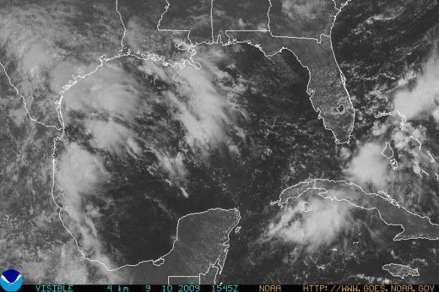
http://www.ghcc.msfc.nasa.gov/GOES/goeseastconus.html
Laredo 27.54N 99.48W looks like some sort of spin, is this suppose to move west just off the coast then north to SE TX and LA?
Laredo 27.54N 99.48W looks like some sort of spin, is this suppose to move west just off the coast then north to SE TX and LA?
0 likes
-
southerngale

- Retired Staff

- Posts: 27418
- Joined: Thu Oct 10, 2002 1:27 am
- Location: Southeast Texas (Beaumont area)
Re: Possible NW Gulf Development Late This Week?
HURAKAN wrote:Elsewhere in the tropics
An upper-level low pressure system has moved over Texas and is expected to spawn a surface low pressure system along the Texas Gulf of Mexico coast on Friday. This low will probably have characteristics of both a tropical and extratropical storm. The surface low is likely to move northeastward and move ashore near the Texas/Louisiana border region on Saturday or Sunday. There will be some high wind shear to the west of the low (shear is currently a high 25 knots), so it is uncertain whether this low will be capable of developing into a tropical cyclone. Regardless, this storm will bring heavy rain capable of causing flooding--and help alleviate the exceptional drought conditions over Southeast Texas.
Jeff Masters
There are some posts/questions for you on page 6.
0 likes
-
HouTXmetro

- Category 5

- Posts: 3949
- Joined: Sun Jun 13, 2004 6:00 pm
- Location: District of Columbia, USA
Re: Possible NW Gulf Development Late This Week?
lrak wrote:http://www.ghcc.msfc.nasa.gov/GOES/goeseastconus.html
Laredo 27.54N 99.48W looks like some sort of spin, is this suppose to move west just off the coast then north to SE TX and LA?
That has a way to go before it reaches the coast.
0 likes
-
HURAKAN
- Professional-Met
- Posts: 46084
- Age: 39
- Joined: Thu May 20, 2004 4:34 pm
- Location: Key West, FL
- Contact:
Re: Re:
gboudx wrote:attallaman wrote:That's strange, all I saw was the word "Latest" and the logo for Photobucket, no sat image. Thanks for clarifying that.
The sat image was being displayed at first. But yes, now all we see is the logo for Photobucket. I guess Hurakan exceeded storage limits or something.
Yes, I exceeded storage limits for the month thanks to Danny's and Erika's RECON missions. I just switched to my other account but this one is getting full too!!!
Latest
0 likes
-
vbhoutex

- Storm2k Executive

- Posts: 29149
- Age: 74
- Joined: Wed Oct 09, 2002 11:31 pm
- Location: Cypress, TX
- Contact:
Re: Possible NW Gulf Development Late This Week?
We already have the low pressure trough set up along the coast. As that spin moves Eastward it will provide the lift needed for more rains. Whether it will help a surface low pressure to form is another question which I have no answers to. I just hope everyone gets beneficial non-flooding rains.
0 likes
-
KFDM Meteorologist

- Professional-Met
- Posts: 1314
- Joined: Tue May 16, 2006 9:52 pm
- Location: Upper Texas Coast/Orange County

Re: Possible NW Gulf Development Late This Week?
how much are you estimating for the beaumont/port arthur area greg?
0 likes
-
KFDM Meteorologist
- Professional-Met
- Posts: 1314
- Joined: Tue May 16, 2006 9:52 pm
- Location: Upper Texas Coast/Orange County
-
southerngale
- Retired Staff
- Posts: 27418
- Joined: Thu Oct 10, 2002 1:27 am
- Location: Southeast Texas (Beaumont area)
-
lrak
- S2K Supporter
- Posts: 1770
- Age: 59
- Joined: Thu Jun 21, 2007 2:48 pm
- Location: Corpus Christi, TX
Re: Possible NW Gulf Development Late This Week?
Check out this radar loop first
http://www.srh.noaa.gov/ridge/radar.php ... 1&loop=yes
Then check out the loop on this visible satellite, looks like something is starting to happen right next to Brownsville?
Pressures are very high though?
http://www.ghcc.msfc.nasa.gov/GOES/goeseastconus.html
http://www.srh.noaa.gov/ridge/radar.php ... 1&loop=yes
Then check out the loop on this visible satellite, looks like something is starting to happen right next to Brownsville?
Pressures are very high though?
http://www.ghcc.msfc.nasa.gov/GOES/goeseastconus.html
0 likes
-
cycloneye

- Admin
- Posts: 149505
- Age: 69
- Joined: Thu Oct 10, 2002 10:54 am
- Location: San Juan, Puerto Rico
Re: Possible NW Gulf Development Late This Week?
12z UKMET develops a weak and very brief tropical storm.
NEW TROPICAL STORM FORECAST TO DEVELOP AFTER 24 HOURS
FORECAST POSITION AT T+ 24 : 27.0N 95.8W
VERIFYING TIME POSITION STRENGTH TENDENCY
-------------- -------- -------- --------
12UTC 11.09.2009 27.0N 95.8W WEAK
00UTC 12.09.2009 27.4N 95.8W WEAK LITTLE CHANGE
12UTC 12.09.2009 28.5N 94.8W WEAK LITTLE CHANGE
00UTC 13.09.2009 30.5N 95.2W WEAK LITTLE CHANGE
12UTC 13.09.2009 31.5N 96.4W WEAK WEAKENING SLIGHTLY
00UTC 14.09.2009 BELOW TROPICAL STORM STRENGTH
http://my.sfwmd.gov/sfwmd/common/images ... /ukmet.txt
http://moe.met.fsu.edu/cgi-bin/ukmtc2.c ... =Animation
0 likes

-
HouTXmetro
- Category 5
- Posts: 3949
- Joined: Sun Jun 13, 2004 6:00 pm
- Location: District of Columbia, USA
-
HURAKAN
- Professional-Met
- Posts: 46084
- Age: 39
- Joined: Thu May 20, 2004 4:34 pm
- Location: Key West, FL
- Contact:
Re: Possible NW Gulf Development Late This Week?
HouTXmetro wrote:Deep convection off the Brownsville coast.
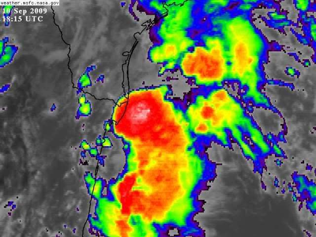
I don't see anything yet at the surface
0 likes
-
cycloneye
- Admin
- Posts: 149505
- Age: 69
- Joined: Thu Oct 10, 2002 10:54 am
- Location: San Juan, Puerto Rico
Re: Possible NW Gulf Development Late This Week?
The spin I see is near Laredo on the Mex/Tex border.

0 likes
-
KFDM Meteorologist
- Professional-Met
- Posts: 1314
- Joined: Tue May 16, 2006 9:52 pm
- Location: Upper Texas Coast/Orange County
Re: Possible NW Gulf Development Late This Week?
12Z EURO develops weak system and moves in near Port Lavaca, Slow N/NE motion. Talk about flooding rains.
http://www.meteo.psu.edu/~gadomski/ECMW ... floop.html
http://www.meteo.psu.edu/~gadomski/ECMW ... floop.html
0 likes
Who is online
Users browsing this forum: No registered users and 175 guests