Possible NW Gulf Development Late This Week?

This is the general tropical discussion area. Anyone can take their shot at predicting a storms path.

Moderator: S2k Moderators

Forum rules

The posts in this forum are NOT official forecasts and should not be used as such. They are just the opinion of the poster and may or may not be backed by sound meteorological data. They are NOT endorsed by any professional institution or STORM2K. For official information, please refer to products from the National Hurricane Center and National Weather Service.

Help Support Storm2K
Message
Author
attallaman

Re:

#241 Postby attallaman » Fri Sep 11, 2009 1:03 pm

bayoubebe wrote:attallaman: it looks awfully close to your area. I'm tired of it already, I hope it does move along, and quickly.

http://www.weather.com/weather/map/inte ... ation=true
You're right, I decided to check the weather radar at WWL TV4.com out of NOLA and the rain does appear to be getting closer to my area.


http://www.wwltv.com/weather/myownradar ... index.html
0 likes   

Frank P
S2K Supporter
S2K Supporter
Posts: 2776
Joined: Fri Aug 29, 2003 10:52 am
Location: Biloxi Beach, Ms
Contact:

Re:

#242 Postby Frank P » Fri Sep 11, 2009 1:03 pm

bayoubebe wrote:attallaman: it looks awfully close to your area. I'm tired of it already, I hope it does move along, and quickly.

http://www.weather.com/weather/map/inte ... ation=true


Yeah it looks to be knocking on our door bb... winds along the beach in Biloxi now are ESE ~15 to 20K in spurts... the GOM looks to be just an ugly mess for the next day or so
0 likes   

User avatar
tailgater
S2K Supporter
S2K Supporter
Posts: 3339
Joined: Sun Jul 11, 2004 9:13 pm
Location: St. Amant La.

Re: Possible NW Gulf Development Late This Week?

#243 Postby tailgater » Fri Sep 11, 2009 1:14 pm

vbhoutex wrote:Looking at buoys and sat loops I see a VERY BROAD low pressure area moving NNE along the TX coast. I know there is a lot of moisture in place that just needs a trigger, but I don't see anything right now that will do that. On the WV one can obviously see all of the moisture. Am I missing some shortwaves or something moving into the area from the West or NW that may trigger the heavier rains? We have had some brief downpours in some areas of SE TX, but nothing of a strong sustained nature as yet. I do think this system was more wound up yesterday than it is today. Just wondering what is going on.
I am not one to disagree with NHC very often, but where are they getting the lowering pressures? I saw no evidence of that in the buoys and in fact most of them were rising slowly.

Pressures are dropping slightly over the last 24hrs. all the way out to the central GOM.
http://www.ndbc.noaa.gov/station_page.php?station=42001
0 likes   

poof121
Category 1
Category 1
Posts: 316
Age: 44
Joined: Tue Sep 11, 2007 11:33 am
Location: Laurel, MD

Re: Possible NW Gulf Development Late This Week?

#244 Postby poof121 » Fri Sep 11, 2009 1:27 pm

FLOOD ADVISORY
NATIONAL WEATHER SERVICE NEW ORLEANS LA
112 PM CDT FRI SEP 11 2009

LAC007-051-057-071-075-087-089-093-095-109-112000-
/O.NEW.KLIX.FA.Y.0060.090911T1812Z-090911T2000Z/
/00000.N.ER.000000T0000Z.000000T0000Z.000000T0000Z.OO/
ST. JOHN THE BAPTIST LA-ST. CHARLES LA-ASSUMPTION LA-ST. JAMES LA-
ST. BERNARD LA-JEFFERSON LA-ORLEANS LA-LAFOURCHE LA-PLAQUEMINES LA-
TERREBONNE LA-
112 PM CDT FRI SEP 11 2009

THE NATIONAL WEATHER SERVICE IN NEW ORLEANS HAS ISSUED AN

* URBAN AND SMALL STREAM FLOOD ADVISORY FOR MINOR FLOODING OF POOR
DRAINAGE AREAS IN...
ASSUMPTION PARISH IN SOUTHEAST LOUISIANA...
JEFFERSON PARISH IN SOUTHEAST LOUISIANA...
LAFOURCHE PARISH IN SOUTHEAST LOUISIANA...
ORLEANS PARISH IN SOUTHEAST LOUISIANA...
PLAQUEMINES PARISH IN SOUTHEAST LOUISIANA...
ST. BERNARD PARISH IN SOUTHEAST LOUISIANA...
ST. CHARLES PARISH IN SOUTHEAST LOUISIANA...
ST. JAMES PARISH IN SOUTHEAST LOUISIANA...
ST. JOHN THE BAPTIST PARISH IN SOUTHEAST LOUISIANA...
TERREBONNE PARISH IN SOUTHEAST LOUISIANA...

* UNTIL 300 PM CDT

* AT 105 PM CDT NATIONAL WEATHER SERVICE METEOROLOGISTS WERE
DETECTING A VERY LARGE AREA OF MODERATE TO HEAVY RAINFALL IN A SWATH
THAT BLANKETS MUCH OF SOUTHEAST LOUISIANA BELOW THE TIDAL LAKES.
THE RAIN AREA WAS STEADILY EXPANDING NORTHWARD AND IS EXPECTED TO
PERSIST THROUGH THE REMAINDER OF THE AFTERNOON. RAIN RATES HAVE BEEN
GENERALLY ONE-HALF INCH TO ONE INCH PER HOUR WITH SOME EMBEDDED
HEAVIER SHOWERS PRODUCING RATES NEAR TWO INCHES PER HOUR AT TIMES.

PONDING OF WATER IN STREETS AND LOW LYING AREAS CAN BE EXPECTED THIS
AFTERNOON. TRAVEL AROUND THE ADVISORY AREA SHOULD BE DONE WITH
CAUTION. DO NOT DRIVE INTO AREAS WHERE WATER CROSSES THE ROAD. ALLOW
EXTRA TIME TO REACH YOUR DESTINATION SAFELY AND FOR POSSIBLE DETOURS
DURING THE EVENING COMMUTE.

PRECAUTIONARY/PREPAREDNESS ACTIONS...

A FLOOD ADVISORY MEANS RIVER OR STREAM FLOWS ARE ELEVATED OR PONDING
OF WATER IN URBAN OR OTHER AREAS IS OCCURRING OR IS IMMINENT. THIS
WILL BE A LONG DURATION RAIN EVENT. ADVISORIES MAY BE EXTENDED IN
TIME LATER...OR POSSIBLY REPLACED BY WATCHES AND WARNINGS IF HEAVY
RAINS PERSIST OR THE THREAT OF PERSISTENT HEAVY RAIN INCREASES
THROUGH THIS WEEKEND.

TO REPORT FLOODING...HAVE THE NEAREST LAW ENFORCEMENT AGENCY RELAY
YOUR REPORT TO THE NATIONAL WEATHER SERVICE FORECAST OFFICE.

&&

LAT...LON 2925 9125 2939 9123 2926 9114 2927 9113
2955 9126 2964 9108 3000 9126 3001 9014
3013 8964 2997 8983 2988 8966 2996 8957
2966 8944 2956 8962 2932 8924 2921 8943
2945 8990 2911 9017 2932 9045 2904 9083

$$


24/RR
0 likes   

CajunMama
Retired Staff
Retired Staff
Posts: 10791
Joined: Thu Feb 06, 2003 9:57 pm
Location: 30.22N, 92.05W Lafayette, LA

Re:

#245 Postby CajunMama » Fri Sep 11, 2009 1:29 pm

bayoubebe wrote:attallaman: it looks awfully close to your area. I'm tired of it already, I hope it does move along, and quickly.

http://www.weather.com/weather/map/inte ... ation=true


I'm not tired of it yet. We've got a deficit of -10.60" here in acadiana so i will gladly take this moisture. I'll even share it with our friends from texas :lol:
0 likes   

User avatar
HURAKAN
Professional-Met
Professional-Met
Posts: 46086
Age: 38
Joined: Thu May 20, 2004 4:34 pm
Location: Key West, FL
Contact:

#246 Postby HURAKAN » Fri Sep 11, 2009 1:40 pm

Image

Image

Be safe and enjoy the rainy weather.
0 likes   

attallaman

Re: Possible NW Gulf Development Late This Week?

#247 Postby attallaman » Fri Sep 11, 2009 1:42 pm

0 likes   

User avatar
HURAKAN
Professional-Met
Professional-Met
Posts: 46086
Age: 38
Joined: Thu May 20, 2004 4:34 pm
Location: Key West, FL
Contact:

#248 Postby HURAKAN » Fri Sep 11, 2009 1:43 pm

TS Grace, 2003:

Image

Could we get another Grace out this system, stay tuned!
0 likes   

User avatar
tailgater
S2K Supporter
S2K Supporter
Posts: 3339
Joined: Sun Jul 11, 2004 9:13 pm
Location: St. Amant La.

Re: Possible NW Gulf Development Late This Week?

#249 Postby tailgater » Fri Sep 11, 2009 1:45 pm

Low now popping up on surface maps east of Freeport

Image
42002 east of brownsville has the lowest preesure at 1010.9mb that I could find.
0 likes   

poof121
Category 1
Category 1
Posts: 316
Age: 44
Joined: Tue Sep 11, 2007 11:33 am
Location: Laurel, MD

Re: Possible NW Gulf Development Late This Week?

#250 Postby poof121 » Fri Sep 11, 2009 1:47 pm

Buoy 42092 (Due South of Galveston, East of Brownsville) showing SSW winds @ 11.7 kts on the west side of some pretty intese convection. LLC forming?

http://www.ndbc.noaa.gov/station_page.php?station=42902
0 likes   

User avatar
HURAKAN
Professional-Met
Professional-Met
Posts: 46086
Age: 38
Joined: Thu May 20, 2004 4:34 pm
Location: Key West, FL
Contact:

#251 Postby HURAKAN » Fri Sep 11, 2009 1:48 pm

Image

Latest
0 likes   

User avatar
HURAKAN
Professional-Met
Professional-Met
Posts: 46086
Age: 38
Joined: Thu May 20, 2004 4:34 pm
Location: Key West, FL
Contact:

Re: Possible NW Gulf Development Late This Week?

#252 Postby HURAKAN » Fri Sep 11, 2009 1:53 pm

982
AGXX40 KNHC 111842
MIMATS

MARINE WEATHER DISCUSSION
NWS TPC/NATIONAL HURRICANE CENTER MIAMI FL
245 PM EDT FRI SEP 11 2009

MARINE WEATHER DISCUSSION FOR THE GULF OF MEXICO...CARIBBEAN SEA
AND SOUTHWEST NORTH ATLC S OF 31N W OF 55W.

GULF OF MEXICO...STRONGEST WINDS CAN BE FOUND OVER THE NORTHERN
GULF THIS AFTERNOON ON THE N SIDE OF A LOW PRESSURE TROUGH FROM
SARASOTA...FL TO NEAR WESTERN CUBA THAT IS EATING INTO MEAN
RIDGING OVER THE EASTERN GULF. WINDS TO 20 KT HAVE BEEN REPORTED
GENERALLY N OF 28N AND E OF 90W OVER THE PAST FEW HOURS.
SCATTERED MODERATE CONVECTION CAN BE FOUND OVER THE NORTH
CENTRAL GULF IN THE MEAN...MOIST SOUTHERLY FLOW ON THE EASTERN
SIDE OF A DEEPENING MID LEVEL LOW OVER TX. CONVECTIVE ACTIVITY
IS EXPECTED IN THIS REGION THROUGH THE WEEKEND. THE MODELS AGREE
ON LIFTING SOME OF THE MID LEVEL ENERGY ASSOCIATED WITH THE
EASTERN GULF TROUGH THROUGH THE GULF OVER THE WEEKEND...STEERED
NORTHWARD BY MEAN SOUTHERLY FLOW BETWEEN THE DEVELOPING
DEEP-LAYERED LOW OVER TX AND THE RIDGING BUILDING INTO THE SE
GULF. MEAN TROUGHING OVER THE NE GULF AND RIDGING OVER THE SE
GULF SHOULD THEN PERSIST THROUGH TUE. HOWEVER...THE DEEP LAYERED
LOW OVER TX SHOULD DRIFT NE EARLY NEXT WEEK AS A COLD FRONT
MOVES IN AND THE UPPER LEVEL TROUGH SUPPORTING THE LOW TURNS
NEGATIVE TILT. THIS WILL SHIFT THE PLENTIFUL SHOWER ACTIVITY
EASTWARD IN THE NORTHERN GULF. THE CMC IS FASTER THAN THAN THE
OTHER MODELS MOVING THE TX LOW NE INTO THE LOWER MISSISSIPPI
VALLEY EARLY NEXT WEEK...SO ITS SOLUTION IS NOT PREFERRED. THE
GFS AND ECMWF ARE IN REASONABLE AGREEMENT ON THE TIMING OF THE
COLD FRONT SURGING S OF THE LOW INTO THE NW GULF ON
MON/TUE...BUT THE GFS IS CONSIDERABLY FARTHER N WITH THE SURFACE
LOW OVER E TX. A MODEL CONSENSUS REPRESENTED BY A BLEND OF THE
ECMWF AND GFS WAS USED FOR THE FORECAST.

SW N ATLC...A SURFACE TROUGH CAN BE FOUND THIS MORNING FROM NEAR
31N73W TO CAPE CANAVERAL...FL WITH A RIDGE AXIS EXTENDING FROM A
1020 MB HIGH PRES SYSTEMS NEAR 29N64W W ALONG 28W TO 29W TO 75W
AND THEN TURNING SW INTO THE STRAITS OF FL. SHORTWAVE ENERGY
ASSOCIATED WITH THE SOUTHERN END OF THE TROUGH OVER THE GULF OF
MEXICO IS EXPECTED TO LIFT NORTHWARD THROUGH THE EASTERN GULF
OVER THE WEEKEND AND THEN DROP SE OFF THE NE FL COAST AS IT
ROUNDS THE HIGH PRES IN THE SE GULF OF MEXICO. AT THE
SURFACE...THE ASSOCIATED TROUGH WILL TRANSITION TO A WAVY
FRONTAL BOUNDARY AS IT IS DRAGGED NORTHWARD THROUGH THE FL
PENINSULA AND THE MODELS AGREE UPON A SURFACE LOW BEING INDUCED
ALONG THE STATIONARY BOUNDARY OFF THE NE FL COAST BY SUN NIGHT.
THE 12Z MODELS HAVE COME INTO BETTER AGREEMENT ON A FORECAST
THAT TAKES THE SURFACE WAVE FROM OFF N FL ON A SE TRACK ALONG
THE STRENGTHENING BAROCLINIC BOUNDARY ASSOCIATED WITH THE LOW
CURRENTLY OFF THE DELMARVA COAST AS IT FINALLY MOVES
NORTHEASTWARD EARLY NEXT WEEK. MEANWHILE...THE BOUNDARY SHOULD
WEAKEN OVER THE FL PENINSULA AS THE MAIN SURFACE LOW SHIFTS E
AND THEN NE ON TUE. ELSEWHERE...THE REMNANTS OF THE WEAK SURFACE
LOW PRES SYSTEM THAT HAD PERSISTED FOR THE LAST TWO DAYS N OF
PUERTO RICO SHOULD BE STEERED NW ALONG THE SW SIDE OF THE
AFOREMENTIONED HIGH PRES SYSTEM E OF THE AREA AND INTO THE
LEADING EDGE OF THE TROUGHING STRETCHED ACROSS THE SW N
ATLC...PUSHING ITS REMNANTS NE OUT OF THE AREA OVER THE WEEKEND.

CARIBBEAN...A TROPICAL WAVE ALONG 80W WILL MOVE W THROUGH THE
WESTERN CARIBBEAN TODAY AND SAT. STRONGEST WINDS ARE TO 20 KT IN
THE CARIBBEAN AND LIE E OF THE WAVE. WINDS SHOULD DIMINISH IN
THE CENTRAL CARIBBEAN OVER THE WEEKEND AS THE HIGH PRES OVER THE
CENTRAL N ATLC WEAKENS. STRONGER WINDS WILL SHIFT INTO THE NW
CARIBBEAN WHERE SE FLOW STEERED BETWEEN HIGH PRES OVER THE SE
GULF OF MEXICO AND LOW PRES OVER THE WESTERN GULF WILL BRING
WINDS TO 20 KT OVER FAR WESTERN WATERS SAT THROUGH MON. TUE
LOOKS LOOKS TO BE A DAY OF WINDS UNDER 20 KT AND SEAS 4 FT OR
LESS OVER THE ENTIRE CARIBBEAN.

TROPICAL N ATLC...WEAK TRADES OF 15 KT OR LESS AND SEAS OF 4 TO
7 FT WILL PERSIST THROUGH THE PERIOD IN THE TROPICAL N ATLC
ZONE. LONG PERIOD E SWELL FROM HURRICANE FRED SHOULD MOVE INTO
THE ZONE OVER THE WEEKEND FOLLOWED BY NORTH SWELL ON MONDAY
WHICH IS EXPECTED TO RAISE SIGNIFICANT WAVE HEIGHTS A FOOT OR
TWO AS IT TRAVELS SOUTH THROUGH THE ZONE. FINALLY...MOST OF THE
MODELS CARRY THE REMNANTS OF FRED EASTWARD TOWARD 45W TO 50 W ON
TUE...WITH SIGNIFICANT SPREAD IN THE LATITUDE OF THE SURFACE
LOW. THE OFFICIAL NHC FORECAST HAS THE 20 KT REMNANT LOW AT
23N49W WED MORNING. HOWEVER...WHAT IS LEFT OF FRED WILL BEGIN TO
APPROACH THE BUILDING RIDGE AXIS TO ITS N BY MON AND THE
EASTERLY WINDS ON THE NORTHERN SIDE OF THE REMNANT LOW ARE
EXPECTED TO EXPAND UNDER THE TIGHT PRES GRADIENT.

WARNINGS

ATLC...
.NONE.

CARIBBEAN...
.NONE.

GULF OF MEXICO...
.NONE

$$
FORECASTER SCHAUER CLARK
0 likes   

attallaman

Re: Possible NW Gulf Development Late This Week?

#253 Postby attallaman » Fri Sep 11, 2009 2:03 pm

Rain has now made it to West Biloxi, it's light rain but it's rain nonetheless. I guess there's more to come.
0 likes   

User avatar
HURAKAN
Professional-Met
Professional-Met
Posts: 46086
Age: 38
Joined: Thu May 20, 2004 4:34 pm
Location: Key West, FL
Contact:

#254 Postby HURAKAN » Fri Sep 11, 2009 2:10 pm

Image

Accuweather's thinking
0 likes   

rrm
Tropical Depression
Tropical Depression
Posts: 65
Joined: Fri May 15, 2009 2:05 pm

Re: Possible NW Gulf Development Late This Week?

#255 Postby rrm » Fri Sep 11, 2009 2:15 pm

does anybody think this will be an invest soon?
0 likes   

User avatar
cycloneye
Admin
Admin
Posts: 145366
Age: 68
Joined: Thu Oct 10, 2002 10:54 am
Location: San Juan, Puerto Rico

Re: Possible NW Gulf Development Late This Week?

#256 Postby cycloneye » Fri Sep 11, 2009 2:17 pm

This is only my opinion.

I see this system at some point soon being a invest regardless it develops or not into a tropical cyclone,because of the bad weather it has for a big area.
0 likes   

User avatar
HURAKAN
Professional-Met
Professional-Met
Posts: 46086
Age: 38
Joined: Thu May 20, 2004 4:34 pm
Location: Key West, FL
Contact:

#257 Postby HURAKAN » Fri Sep 11, 2009 2:31 pm

Image

A lot of moisture
0 likes   

User avatar
ronjon
Category 5
Category 5
Posts: 4822
Joined: Fri Aug 19, 2005 5:17 pm
Location: Hernando Beach, FL

Re: Possible NW Gulf Development Late This Week?

#258 Postby ronjon » Fri Sep 11, 2009 2:38 pm

A ton of moisture Hurakan that's not going anywhere in a hurry - the models prog that mid-level low in Tx to only slowly migrate east and northeast over the next 4-5 days.
0 likes   

User avatar
vbhoutex
Storm2k Executive
Storm2k Executive
Posts: 29113
Age: 73
Joined: Wed Oct 09, 2002 11:31 pm
Location: Cypress, TX
Contact:

Re: Possible NW Gulf Development Late This Week?

#259 Postby vbhoutex » Fri Sep 11, 2009 3:12 pm

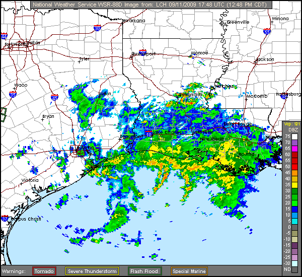
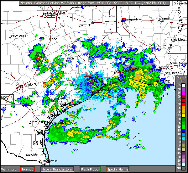
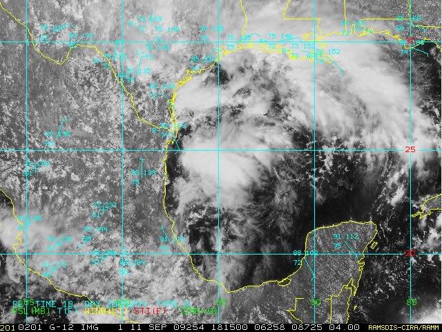
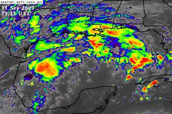
Another look at the sat loops and the buoys does indicate the possibility that a sfc low may be trying to form now. Pressures are definitely dropping now, but is it just the norm for this time of day? Time will tell. IF it is happening it has a long ways to go. I won't even attempt to put coords for a broad CC at this point, but IF it is happening, I don't see it happening where many think it will. Also obvious is the mid level low over S CNTRL TX near the coast which is basically meandering around. When something triggers the moisture, which has happened in a big way in some areas of S CNTRL TX today, there could be widespread heavy rains all along the Gulf Coast from TX to AL.
The posts in this forum are NOT official forecast and should not be used as such. They are just the opinion of the poster and may or may not be backed by sound meteorological data. They are NOT endorsed by any professional institution or storm2k.org. For official information, please refer to the NHC and NWS products.
0 likes   

djones65
Category 1
Category 1
Posts: 264
Age: 59
Joined: Mon Jun 20, 2005 12:05 am
Location: Ocean Springs, MS

Re: Possible NW Gulf Development Late This Week?

#260 Postby djones65 » Fri Sep 11, 2009 3:24 pm

Surface pressures will always fluctuate up and down diurnally.
I look at 24 hour trends to determine whether pressures are rising or falling. Just because a synoptic report may show a rising pressure at the observation time is not that important to me unless it is during the time it should be falling diurnally. What I look at is to compare the pressures at 12 or 24 hour increments. Typically a pressure drop of greater than 3 mb in 24 hours is a good indicator of something possibly forming. Buoy 42020 50 miles southeast of Corpus Christi, TX shows a 24 hour pressure fall of 2.3 mb. At 1950UTC the pressure was 29.85" and same time yesterday it was 29.92"

With that being said I personally do not believe we will see a tropical cyclone develop out of this system. I do believe we will see a broad low pressure area with multiple vortices that will track north northeast into western and central Louisiana on Sunday. However, the upper level shear will be too strong to allow the system to become vertically aligned.
0 likes   


Return to “Talkin' Tropics”

Who is online

Users browsing this forum: 869MB, LarryWx, Lizzytiz1, USTropics and 56 guests