ATL: TROPICAL LOW ex-FRED (ex-07L)
Moderator: S2k Moderators
-
Derek Ortt


-
gatorcane

- S2K Supporter

- Posts: 23708
- Age: 48
- Joined: Sun Mar 13, 2005 3:54 pm
- Location: Boca Raton, FL
Re: ATL: TROPICAL DEPRESSION FRED (07L)
jconsor wrote:A small but intense area of convection has blown up on the north side of Fred in the past 3 hours. This is a sign of life, even if shear values are prohibitively high now and will be for the 2 days. Also, Fred is still moving WNW and is 50-100 miles south of the NHC forecast and other model guidance.
Well certainly that is why I have been a bit more interested in Fred the past couple of days despite a general lack of interest from members. A ridge is building in across most of the Central Atlantic over the next week or so and Fred still has a good tight structure albeit being sheared at the moment.
This area does have a chance to regenerate next week, when upper-level winds become more favorable farther west. Question is how much of Fred's remnant low will be left by then?
0 likes

Re: ATL: TROPICAL DEPRESSION FRED (07L)
Not a complete lack of interest, gatorcane - I'm still checking in on the posts and watching Fred,
or what remains of him at the moment!
or what remains of him at the moment!
0 likes
-
brunota2003

- S2K Supporter
- Posts: 9476
- Age: 35
- Joined: Sat Jul 30, 2005 9:56 pm
- Location: Stanton, KY...formerly Havelock, NC
- Contact:
-
cycloneye

- Admin

- Posts: 149219
- Age: 69
- Joined: Thu Oct 10, 2002 10:54 am
- Location: San Juan, Puerto Rico
Re: ATL: TROPICAL DEPRESSION FRED (07L)
TWOAT
TROPICAL WEATHER OUTLOOK
NWS TPC/NATIONAL HURRICANE CENTER MIAMI FL
200 PM EDT SUN SEP 13 2009
FOR THE NORTH ATLANTIC...CARIBBEAN SEA AND THE GULF OF MEXICO...
A LOW PRESSURE AREA...THE REMNANT CIRCULATION OF FRED...IS LOCATED
ABOUT 675 MILES WEST OF THE NORTHERNMOST CAPE VERDE ISLANDS. WHILE
REGENERATION INTO A TROPICAL CYCLONE IS NOT EXPECTED DURING THE
NEXT COUPLE OF DAYS...THIS SYSTEM IS LIKELY TO CONTINUE PRODUCING
DISORGANIZED AND INTERMITTENT SHOWERS AND THUNDERSTORMS AS IT MOVES
SLOWLY WESTWARD. THERE IS A LOW CHANCE...LESS THAN 30 PERCENT...OF
THIS SYSTEM BECOMING A TROPICAL CYCLONE AGAIN DURING THE NEXT 48
HOURS.
ELSEWHERE...TROPICAL CYCLONE FORMATION IS NOT EXPECTED DURING THE
NEXT 48 HOURS.
$$
FORECASTER BROWN
0 likes
-
cycloneye
- Admin
- Posts: 149219
- Age: 69
- Joined: Thu Oct 10, 2002 10:54 am
- Location: San Juan, Puerto Rico
Re: ATL: TROPICAL DEPRESSION FRED (07L)
Best track keeps ploting.
AL, 07, 2009091318, , BEST, 0, 185N, 354W, 30, 1007, LO
ftp://ftp.tpc.ncep.noaa.gov/atcf/tcweb/ ... 009.invest
AL, 07, 2009091318, , BEST, 0, 185N, 354W, 30, 1007, LO
ftp://ftp.tpc.ncep.noaa.gov/atcf/tcweb/ ... 009.invest
0 likes
-
brunota2003
- S2K Supporter
- Posts: 9476
- Age: 35
- Joined: Sat Jul 30, 2005 9:56 pm
- Location: Stanton, KY...formerly Havelock, NC
- Contact:
I think we need a Code Orange...that convection has been there for most of the day, and it is creeping closer to the center and getting deeper...granted, it is still clearly sheared, but this is by no means a remnant low.
1915 UTC VIS:

1915 UTC IR:

The thing is...they aren't disorganized, they've been concentrated in the same spot, slowly trying to work towards the center against the shear. Secondly, the storms on IR are anything but intermittent...they've been there for over 6 hours at least, maybe even 8 or 12 hours.
1915 UTC VIS:
1915 UTC IR:
TROPICAL WEATHER OUTLOOK
NWS TPC/NATIONAL HURRICANE CENTER MIAMI FL
200 PM EDT SUN SEP 13 2009
FOR THE NORTH ATLANTIC...CARIBBEAN SEA AND THE GULF OF MEXICO...
A LOW PRESSURE AREA...THE REMNANT CIRCULATION OF FRED...IS LOCATED
ABOUT 675 MILES WEST OF THE NORTHERNMOST CAPE VERDE ISLANDS. WHILE
REGENERATION INTO A TROPICAL CYCLONE IS NOT EXPECTED DURING THE
NEXT COUPLE OF DAYS...THIS SYSTEM IS LIKELY TO CONTINUE PRODUCING
DISORGANIZED AND INTERMITTENT SHOWERS AND THUNDERSTORMS AS IT MOVES
SLOWLY WESTWARD. THERE IS A LOW CHANCE...LESS THAN 30 PERCENT...OF
THIS SYSTEM BECOMING A TROPICAL CYCLONE AGAIN DURING THE NEXT 48
HOURS.
ELSEWHERE...TROPICAL CYCLONE FORMATION IS NOT EXPECTED DURING THE
NEXT 48 HOURS.
$$
FORECASTER BROWN
The thing is...they aren't disorganized, they've been concentrated in the same spot, slowly trying to work towards the center against the shear. Secondly, the storms on IR are anything but intermittent...they've been there for over 6 hours at least, maybe even 8 or 12 hours.
Last edited by brunota2003 on Sun Sep 13, 2009 2:55 pm, edited 1 time in total.
0 likes
-
DESTRUCTION5

- Category 5

- Posts: 4430
- Age: 44
- Joined: Wed Sep 03, 2003 11:25 am
- Location: Stuart, FL
-
Derek Ortt
http://metofis.rsmas.miami.edu/~dortt/s ... 1_loop.gif
with this trough basically OVER the storm, the chances of development are slim and none, and I think I saw slim leave the hotel already
with this trough basically OVER the storm, the chances of development are slim and none, and I think I saw slim leave the hotel already
0 likes
-
ozonepete
- Professional-Met

- Posts: 4743
- Joined: Mon Sep 07, 2009 3:23 pm
- Location: From Ozone Park, NYC / Now in Brooklyn, NY
Re:
Derek Ortt wrote:http://metofis.rsmas.miami.edu/~dortt/satellite/C_Atl/WV/atl_wv1_loop.gif
with this trough basically OVER the storm, the chances of development are slim and none, and I think I saw slim leave the hotel already
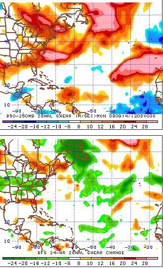
I'd have to pretty much agree, but ... Though I think most of us agree the GFS has been really bad with shear, here's its shear forecast for tomorrow morning, for what it's worth. Note the break in the shear developing near and in front of Fred.
0 likes
-
Derek Ortt
-
Emmett_Brown

- Category 5
- Posts: 1433
- Joined: Wed Aug 24, 2005 9:10 pm
- Location: Sarasota FL
Re: ATL: TROPICAL DEPRESSION FRED (07L)
Derek Ortt wrote:the lower shear may be due to the system being under the UL. Tropical waves usually don't develop there. This type of development is usually at higher latitudes later in the season
True, but this isn't a wave, it is a closed low pressure area.
0 likes
-
AdamFirst

- S2K Supporter
- Posts: 2490
- Age: 36
- Joined: Thu Aug 14, 2008 10:54 am
- Location: Port Saint Lucie, FL
Upgraded to Code Orange
SPECIAL TROPICAL WEATHER OUTLOOK
NWS TPC/NATIONAL HURRICANE CENTER MIAMI FL
435 PM EDT SUN SEP 13 2009
FOR THE NORTH ATLANTIC...CARIBBEAN SEA AND THE GULF OF MEXICO...
SPECIAL OUTLOOK ISSUED FOR THE REMNANTS OF FRED.
1. UPDATED...SHOWER AND THUNDERSTORM ACTIVITY HAS INCREASED TO THE
NORTH OF THE CENTER OF THE REMNANT CIRCULATION OF FRED...WHICH IS
LOCATED ABOUT 700 MILES WEST-NORTHWEST OF THE NORTHERNMOST CAPE
VERDE ISLANDS. WHILE UPPER-LEVEL WINDS ARE EXPECTED TO REMAIN
UNFAVORABLE FOR RE-DEVELOPMENT AS THIS SYSTEM MOVES SLOWLY WESTWARD
OVER THE NEXT COUPLE OF DAYS...REGENERATION INTO A TROPICAL CYCLONE
IS POSSIBLE IF SHOWER AND THUNDERSTORM ACTIVITY CONTINUES TO BECOME
BETTER ORGANIZED. THERE IS A MEDIUM CHANCE...30 TO 50 PERCENT...OF
THIS SYSTEM BECOMING A TROPICAL CYCLONE DURING THE NEXT 48 HOURS.
0 likes
-
emeraldislencguy
- S2K Supporter
- Posts: 207
- Joined: Sun Aug 27, 2006 4:35 pm
- Location: emerald isle nc
- Contact:
Re: ATL: TROPICAL DEPRESSION FRED (07L)
It has been updated to ORANGE
Love to read all the why it will not regenerate and then they change it to a code orange
Sometimes the so called experts on here have to eat crow
Love to read all the why it will not regenerate and then they change it to a code orange
Sometimes the so called experts on here have to eat crow
0 likes
Re:
Wow....just a couple of hours ago the NHC was saying:
WHILE REGENERATION INTO A TROPICAL CYCLONE IS NOT EXPECTED DURING THE
NEXT COUPLE OF DAYS...THIS SYSTEM IS LIKELY TO CONTINUE PRODUCING
DISORGANIZED AND INTERMITTENT SHOWERS AND THUNDERSTORMS AS IT MOVES
SLOWLY WESTWARD.
WHILE REGENERATION INTO A TROPICAL CYCLONE IS NOT EXPECTED DURING THE
NEXT COUPLE OF DAYS...THIS SYSTEM IS LIKELY TO CONTINUE PRODUCING
DISORGANIZED AND INTERMITTENT SHOWERS AND THUNDERSTORMS AS IT MOVES
SLOWLY WESTWARD.
AdamFirst wrote:Upgraded to Code Orange
SPECIAL TROPICAL WEATHER OUTLOOK
NWS TPC/NATIONAL HURRICANE CENTER MIAMI FL
435 PM EDT SUN SEP 13 2009
FOR THE NORTH ATLANTIC...CARIBBEAN SEA AND THE GULF OF MEXICO...
SPECIAL OUTLOOK ISSUED FOR THE REMNANTS OF FRED.
1. UPDATED...SHOWER AND THUNDERSTORM ACTIVITY HAS INCREASED TO THE
NORTH OF THE CENTER OF THE REMNANT CIRCULATION OF FRED...WHICH IS
LOCATED ABOUT 700 MILES WEST-NORTHWEST OF THE NORTHERNMOST CAPE
VERDE ISLANDS. WHILE UPPER-LEVEL WINDS ARE EXPECTED TO REMAIN
UNFAVORABLE FOR RE-DEVELOPMENT AS THIS SYSTEM MOVES SLOWLY WESTWARD
OVER THE NEXT COUPLE OF DAYS...REGENERATION INTO A TROPICAL CYCLONE
IS POSSIBLE IF SHOWER AND THUNDERSTORM ACTIVITY CONTINUES TO BECOME
BETTER ORGANIZED. THERE IS A MEDIUM CHANCE...30 TO 50 PERCENT...OF
THIS SYSTEM BECOMING A TROPICAL CYCLONE DURING THE NEXT 48 HOURS.
0 likes
-
cycloneye
- Admin
- Posts: 149219
- Age: 69
- Joined: Thu Oct 10, 2002 10:54 am
- Location: San Juan, Puerto Rico
Re: ATL: TROPICAL DEPRESSION FRED (07L) (Code Orange)
That saying comes to the front burner again= (Never say never in the tropics)
0 likes
-
ozonepete
- Professional-Met
- Posts: 4743
- Joined: Mon Sep 07, 2009 3:23 pm
- Location: From Ozone Park, NYC / Now in Brooklyn, NY
Re:
brunota2003 wrote:I think we need a Code Orange...that convection has been there for most of the day, and it is creeping closer to the center and getting deeper...granted, it is still clearly sheared, but this is by no means a remnant low.
Nice call!
0 likes
Who is online
Users browsing this forum: No registered users and 1 guest