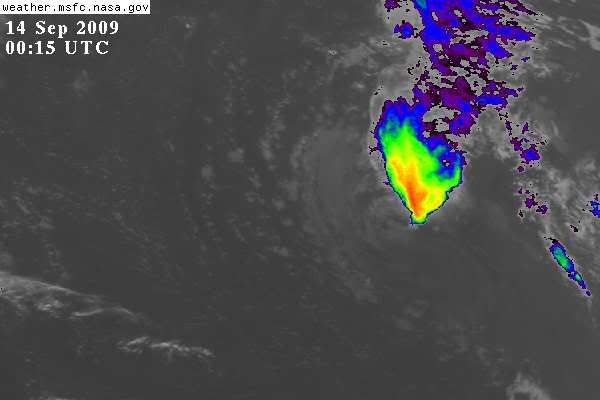
ATL: TROPICAL LOW ex-FRED (ex-07L)

Moderator: S2k Moderators

Message
Author
User avatar
Ivanhater
Storm2k Moderator
Storm2k Moderator
Posts: 11161
Age: 38
Joined: Fri Jul 01, 2005 8:25 am
Location: Pensacola

Re: ATL: HURRICANE FRED (07L)

#761 Postby Ivanhater » Sun Sep 13, 2009 7:33 pm

wxman57 wrote:
cycloneye wrote:The big question is what will be left of Fred as the consensus of the models is after going north,then turns west.


Remnant swirl of clouds like the wave ahead of it? It's NOT heading for the Caribbean or the U.S.


These certainty posts always find a way to come back to burn
0 likes   

User avatar
cycloneye
Admin
Admin
Posts: 145332
Age: 68
Joined: Thu Oct 10, 2002 10:54 am
Location: San Juan, Puerto Rico

Re: ATL: TROPICAL DEPRESSION FRED (07L)

#762 Postby cycloneye » Sun Sep 13, 2009 7:36 pm

Best Track again keeps tracking it in the 00 UTC update.

AL, 07, 2009091400, , BEST, 0, 187N, 362W, 30, 1007, LO

ftp://ftp.tpc.ncep.noaa.gov/atcf/tcweb/ ... 009.invest
0 likes   

User avatar
HURAKAN
Professional-Met
Professional-Met
Posts: 46086
Age: 38
Joined: Thu May 20, 2004 4:34 pm
Location: Key West, FL
Contact:

#763 Postby HURAKAN » Sun Sep 13, 2009 7:37 pm

Image

Looks like shear is winning
0 likes   

User avatar
Gustywind
Category 5
Category 5
Posts: 12334
Joined: Mon Sep 03, 2007 7:29 am
Location: Baie-Mahault, GUADELOUPE

Re: ATL: TROPICAL DEPRESSION FRED (07L)

#764 Postby Gustywind » Sun Sep 13, 2009 7:37 pm

perk wrote:
IvanSurvivor wrote:I worry about storms with 4 letters in their name...Erin, Opal, Ivan...

I'm not very fund of 3 letter storms neither.(Ike). :D

:cheesy: in 4 letters do not forget EDNA in 1953, GERT in 1981, JOSE in 1999, DEAN more recently in 2007 and last year OMAR! :ggreen: I'm not very fund of 3 letter storms neither: DOG in 1950.
0 likes   

IvanSurvivor
Tropical Storm
Tropical Storm
Posts: 152
Joined: Wed Aug 20, 2008 12:12 am
Location: Pensacola Florida (Warrington)

Re: ATL: TROPICAL DEPRESSION FRED (07L)

#765 Postby IvanSurvivor » Sun Sep 13, 2009 7:49 pm

Hugo, Luis, Cleo, Inez, Erin, Opal, Ivan, Edna, Gert, Jose, Dean, Omar...Coincidence, I think not :eek: Fred...J/K
0 likes   

Derek Ortt

#766 Postby Derek Ortt » Sun Sep 13, 2009 7:51 pm

this is still unlikely to come near the USA or Caribbean. Low likely will dissipate within the next 48 hours.
0 likes   

User avatar
BigA
Professional-Met
Professional-Met
Posts: 1317
Joined: Sun Jul 24, 2005 10:56 pm

Re:

#767 Postby BigA » Sun Sep 13, 2009 8:15 pm

Derek Ortt wrote:this is still unlikely to come near the USA or Caribbean. Low likely will dissipate within the next 48 hours.


I don't understand why. All the shear maps that I've looked at show shear collapsing in the next 48 hours, and even if that did not happen, why would shear affect a remnant swirl that doesn't reach high enough into the atmosphere to be sheared? Is it because with a lack of convection, the low level circulation will dissipate?
0 likes   

User avatar
brunota2003
S2K Supporter
S2K Supporter
Posts: 9476
Age: 34
Joined: Sat Jul 30, 2005 9:56 pm
Location: Stanton, KY...formerly Havelock, NC
Contact:

Re: Re:

#768 Postby brunota2003 » Sun Sep 13, 2009 8:33 pm

BigA wrote:
Derek Ortt wrote:this is still unlikely to come near the USA or Caribbean. Low likely will dissipate within the next 48 hours.


I don't understand why. All the shear maps that I've looked at show shear collapsing in the next 48 hours, and even if that did not happen, why would shear affect a remnant swirl that doesn't reach high enough into the atmosphere to be sheared? Is it because with a lack of convection, the low level circulation will dissipate?

Yes...without convection to keep the wheel turning, it slowly spins down until it eventually opens up.
0 likes   

User avatar
AdamFirst
S2K Supporter
S2K Supporter
Posts: 2491
Age: 36
Joined: Thu Aug 14, 2008 10:54 am
Location: Port Saint Lucie, FL

#769 Postby AdamFirst » Sun Sep 13, 2009 9:23 pm

It's starting to trek across the shear gauntlet...lets see if it survives over the next day
0 likes   

User avatar
gatorcane
S2K Supporter
S2K Supporter
Posts: 23691
Age: 47
Joined: Sun Mar 13, 2005 3:54 pm
Location: Boca Raton, FL

#770 Postby gatorcane » Sun Sep 13, 2009 10:14 pm

Looking at the NHC outlook from 8pm EST, I don't think I have ever seen where it indicates that upper-level winds are unfavorable but yet a tropical storm could still form.

At any rate, convection continues to wane tonight as shear continues to pound the remnant low. One thing I do notice is that the low-level circulation continues to be vigorous, even looking at IR. Upper-level winds are dropping off out ahead of the low, but it won't hit them for a couple of more days.

In all likelyhood, it likely it will not regenerate again, but it is something to just keep an eye on every so often in case it decides to regenerate. Even if it does regenerate the models seem to drop heights off coast Eastern North America by day 7, which would force a recurve anyway.
0 likes   

blazess556
Professional-Met
Professional-Met
Posts: 250
Joined: Mon Aug 31, 2009 10:51 pm
Location: Germantown, MD

#771 Postby blazess556 » Sun Sep 13, 2009 11:41 pm

0 likes   

User avatar
Typhoon_Willie
Category 5
Category 5
Posts: 1042
Joined: Mon Jun 09, 2003 3:19 pm
Location: Greenacres City, Florida

Re: ATL: TROPICAL DEPRESSION FRED (07L) - Computer Models

#772 Postby Typhoon_Willie » Sun Sep 13, 2009 11:55 pm

1. SHOWER AND THUNDERSTORM ACTIVITY CONTINUES IN ASSOCIATION WITH THE
REMNANTS OF FRED...WHICH ARE LOCATED ABOUT 725 MILES WEST-NORTHWEST
OF THE NORTHERNMOST CAPE VERDE ISLANDS AND MOVING SLOWLY WESTWARD.
WHILE UPPER-LEVEL WINDS ARE EXPECTED TO REMAIN UNFAVORABLE FOR
RE-DEVELOPMENT...REGENERATION OF THIS SYSTEM INTO A TROPICAL
CYCLONE IS POSSIBLE IF THE ORGANIZATION OF THE SHOWER AND
THUNDERSTORM ACTIVITY INCREASES. THERE IS A MEDIUM CHANCE...30 TO
50 PERCENT...OF THIS SYSTEM BECOMING A TROPICAL CYCLONE DURING THE
NEXT 48 HOURS. ADDITIONAL INFORMATION ON THIS SYSTEM CAN BE FOUND
IN HIGH SEAS FORECASTS ISSUED BY THE NATIONAL WEATHER SERVICE...
UNDER AWIPS HEADER NFDHSFAT1 AND WMO HEADER FZNT01 KWBC.


I guess we will have to wait and see if regeneration of Fred will occur.
0 likes   

Derek Ortt

#773 Postby Derek Ortt » Mon Sep 14, 2009 12:12 am

it hits as a weak wave
0 likes   

User avatar
blp
Category 5
Category 5
Posts: 2840
Age: 46
Joined: Thu Sep 09, 2004 7:51 pm
Location: Miami, FL
Contact:

Re: ATL: TROPICAL DEPRESSION FRED (07L) - Computer Models

#774 Postby blp » Mon Sep 14, 2009 12:24 am

00z NOGAPS regenerates Fred and strengthens it under a ridge toward the end.

https://www.fnmoc.navy.mil/wxmap_cgi/cg ... 2009091400
0 likes   

User avatar
Hurricaneman
Category 5
Category 5
Posts: 7351
Age: 45
Joined: Tue Aug 31, 2004 3:24 pm
Location: central florida

Re: ATL: TROPICAL DEPRESSION FRED (07L)

#775 Postby Hurricaneman » Mon Sep 14, 2009 12:33 am

that gfs image is in 174, it could be stronger than what is shown because of the resolution that far out, and thats still too far out to tell where this is going

right now we dont even know if this will survive, but if it stays south of 19n this will not regenerate, but if this is north of 19n this has a fighting chance to possibily regenerate into a tropical storm

The posts in this forum are NOT official forecast and should not be used as such. They are just the opinion of the poster and may or may not be backed by sound meteorological data. They are NOT endorsed by any professional institution or storm2k.org. For official information, please refer to the NHC and NWS products.
0 likes   

User avatar
blp
Category 5
Category 5
Posts: 2840
Age: 46
Joined: Thu Sep 09, 2004 7:51 pm
Location: Miami, FL
Contact:

Re: ATL: TROPICAL DEPRESSION FRED (07L) - Computer Models

#776 Postby blp » Mon Sep 14, 2009 12:47 am

0 likes   

User avatar
RattleMan
Category 5
Category 5
Posts: 1218
Joined: Wed Aug 24, 2005 7:14 pm
Location: Phoenix, AZ

Re: ATL: TROPICAL DEPRESSION FRED (07L)

#777 Postby RattleMan » Mon Sep 14, 2009 1:10 am

Back to yellow:

000
ABNT20 KNHC 140547
TWOAT
TROPICAL WEATHER OUTLOOK
NWS TPC/NATIONAL HURRICANE CENTER MIAMI FL
200 AM EDT MON SEP 14 2009

FOR THE NORTH ATLANTIC...CARIBBEAN SEA AND THE GULF OF MEXICO...

THE REMNANTS OF FRED ARE LOCATED ABOUT 800 MILES WEST OF THE
NORTHERNMOST CAPE VERDE ISLANDS. ASSOCIATED SHOWER AND THUNDERSTORM
ACTIVITY HAS DIMINISHED OVER THE PAST FEW HOURS...AND UPPER-LEVEL
WINDS ARE EXPECTED TO REMAIN UNFAVORABLE FOR RE-DEVELOPMENT. HOWEVER
...THIS SYSTEM MAY CONTINUE TO PRODUCE INTERMITTENT SHOWER AND
THUNDERSTORM ACTIVITY AS IT MOVES SLOWLY WESTWARD OVER THE NEXT
COUPLE OF DAYS. THERE IS A LOW CHANCE...LESS THAN 30 PERCENT...OF
THIS SYSTEM BECOMING A TROPICAL CYCLONE DURING THE NEXT 48 HOURS.
ADDITIONAL INFORMATION ON THIS SYSTEM CAN BE FOUND IN HIGH SEAS
FORECASTS ISSUED BY THE NATIONAL WEATHER SERVICE...UNDER AWIPS
HEADER NFDHSFAT1 AND WMO HEADER FZNT01 KWBC.

ELSEWHERE...TROPICAL CYCLONE FORMATION IS NOT EXPECTED DURING THE
NEXT 48 HOURS.

$$
FORECASTER BRENNAN
0 likes   

User avatar
cycloneye
Admin
Admin
Posts: 145332
Age: 68
Joined: Thu Oct 10, 2002 10:54 am
Location: San Juan, Puerto Rico

Re: ATL: TROPICAL DEPRESSION FRED (07L)

#778 Postby cycloneye » Mon Sep 14, 2009 6:50 am

TROPICAL WEATHER OUTLOOK
NWS TPC/NATIONAL HURRICANE CENTER MIAMI FL
800 AM EDT MON SEP 14 2009

FOR THE NORTH ATLANTIC...CARIBBEAN SEA AND THE GULF OF MEXICO...

THE REMNANTS OF FRED ARE LOCATED ABOUT 900 MILES WEST OF THE
NORTHERNMOST CAPE VERDE ISLANDS. ASSOCIATED SHOWER AND THUNDERSTORM
ACTIVITY REMAINS LIMITED...AND UPPER-LEVEL WINDS ARE EXPECTED TO
REMAIN UNFAVORABLE FOR RE-DEVELOPMENT. HOWEVER...THIS SYSTEM MAY
CONTINUE TO PRODUCE INTERMITTENT SHOWER AND THUNDERSTORM ACTIVITY
AS IT MOVES WEST-NORTHWESTWARD AT 10 TO 15 MPH OVER THE NEXT COUPLE
OF DAYS. THERE IS A LOW CHANCE...LESS THAN 30 PERCENT...OF THIS
SYSTEM BECOMING A TROPICAL CYCLONE DURING THE NEXT 48 HOURS.
ADDITIONAL INFORMATION ON THIS SYSTEM CAN BE FOUND IN HIGH SEAS
FORECASTS ISSUED BY THE NATIONAL WEATHER SERVICE...UNDER AWIPS
HEADER NFDHSFAT1 AND WMO HEADER FZNT01 KWBC.

ELSEWHERE...TROPICAL CYCLONE FORMATION IS NOT EXPECTED DURING THE
NEXT 48 HOURS.

$$
FORECASTER BERG
0 likes   

User avatar
alan1961
Category 2
Category 2
Posts: 771
Joined: Mon Mar 20, 2006 11:58 am
Location: Derby, Derbyshire, England
Contact:

Re: ATL: TROPICAL DEPRESSION FRED (07L)

#779 Postby alan1961 » Mon Sep 14, 2009 6:57 am

Convection trying to work its way into the circulation.
0 likes   

User avatar
cycloneye
Admin
Admin
Posts: 145332
Age: 68
Joined: Thu Oct 10, 2002 10:54 am
Location: San Juan, Puerto Rico

Re: ATL: TROPICAL DEPRESSION FRED (07L)

#780 Postby cycloneye » Mon Sep 14, 2009 7:22 am

12 UTC Best Track.

AL, 07, 2009091412, , BEST, 0, 190N, 390W, 30, 1007, LO

ftp://ftp.tpc.ncep.noaa.gov/atcf/tcweb/ ... 009.invest
0 likes   


Return to “2009”

Who is online

Users browsing this forum: No registered users and 5 guests