WPAC : TROPICAL STORM CHOI-WAN (15W)
Moderator: S2k Moderators
-
Derek Ortt
-
CrazyC83
- Professional-Met

- Posts: 34316
- Joined: Tue Mar 07, 2006 11:57 pm
- Location: Deep South, for the first time!
Re: WPAC: SUPER-TYPHOON CHOI-WAN (15W)
15/1430 UTC 18.0N 144.6E T7.0/7.0 CHOI-WAN -- West Pacific
0 likes
-
HURAKAN

- Professional-Met
- Posts: 46084
- Age: 39
- Joined: Thu May 20, 2004 4:34 pm
- Location: Key West, FL
- Contact:
Re: WPAC: SUPER-TYPHOON CHOI-WAN (15W)
UW - CIMSS
ADVANCED DVORAK TECHNIQUE
ADT-Version 7.2.3
Tropical Cyclone Intensity Algorithm
----- Current Analysis -----
Date : 15 SEP 2009 Time : 143000 UTC
Lat : 18:00:04 N Lon : 144:35:40 E
CI# /Pressure/ Vmax
6.9 / 903.1mb/137.4kt
Final T# Adj T# Raw T#
(3hr avg)
6.9 6.9 6.9
Latitude bias adjustment to MSLP : +1.9mb
Estimated radius of max. wind based on IR : 20 km
Center Temp : +20.2C Cloud Region Temp : -74.3C
Scene Type : EYE
Positioning Method : RING/SPIRAL COMBINATION
Ocean Basin : WEST PACIFIC
Dvorak CI > MSLP Conversion Used : PACIFIC
Tno/CI Rules : Constraint Limits : NO LIMIT
Weakening Flag : OFF
Rapid Dissipation Flag : OFF
0 likes
-
CrazyC83
- Professional-Met
- Posts: 34316
- Joined: Tue Mar 07, 2006 11:57 pm
- Location: Deep South, for the first time!
Re: WPAC: SUPER-TYPHOON CHOI-WAN (15W)
cycloneye wrote::uarrow: And the Japanese still say is not a Super-Typhoon.
That is because Super Typhoon is an unofficial classification. The JMA does not use that term even if it was T8.0.
Eye temperature of 20C = really impressive.
0 likes
-
brunota2003

- S2K Supporter

- Posts: 9476
- Age: 35
- Joined: Sat Jul 30, 2005 9:56 pm
- Location: Stanton, KY...formerly Havelock, NC
- Contact:
Re:
HURAKAN wrote:
The size Choi-wan compared to the US
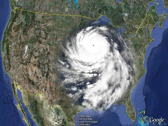
Is a fairly big storm, taking up at good portion of the East Coast if it were to make landfall in the Atlantic
0 likes
-
brunota2003
- S2K Supporter
- Posts: 9476
- Age: 35
- Joined: Sat Jul 30, 2005 9:56 pm
- Location: Stanton, KY...formerly Havelock, NC
- Contact:
-
HURAKAN
- Professional-Met
- Posts: 46084
- Age: 39
- Joined: Thu May 20, 2004 4:34 pm
- Location: Key West, FL
- Contact:
Re:
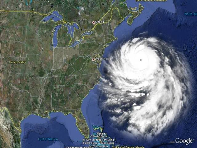
CrazyC83 wrote:JMA said that tropical storm winds go out up to 350 nautical miles from the eye.
Using Google Earth, that's like having tropical storm winds from Miami to mid-Georgia coast and from Miami to the Cayman Islands! WOW!
0 likes


Re: WPAC: SUPER-TYPHOON CHOI-WAN (15W)
Definitley an eyewall I dont want to experience! It is huge typhoon. Can you imagine what the small islands N of Saipan experienced earlier today?
0 likes
-
cycloneye

- Admin

- Posts: 149727
- Age: 69
- Joined: Thu Oct 10, 2002 10:54 am
- Location: San Juan, Puerto Rico
Re: WPAC: SUPER-TYPHOON CHOI-WAN (15W)
Does anyone has information about how many people live in IWO-JIMA? That island is in the forecast track.
0 likes


Re: WPAC: SUPER-TYPHOON CHOI-WAN (15W)
Definitely an eyewall I want to experience and would pay good money to be in ! 
0 likes
-
HURAKAN
- Professional-Met
- Posts: 46084
- Age: 39
- Joined: Thu May 20, 2004 4:34 pm
- Location: Key West, FL
- Contact:
Re: WPAC: SUPER-TYPHOON CHOI-WAN (15W)
cycloneye wrote:Does anyone has information about how many people live in IWO-JIMA? That island is in the forecast track.
I think there is a military base and it has no civilian population. Maybe Chacor or anyone else has a more accurate information.
0 likes


Re:
Derek Ortt wrote:not officially a super typhoon. That is not an official JMA classification. The 1 minute conversion is also below 130KT
Remeber that the conversion factor is an aproximation, if we use it then the current intensity would be 115 kt. But it doesn't look like a 115 kt typhoon, I'm sure that if this thing was in the ATL nobody would be doubting those 135 kt. I don't think that the JMA and the JTWC intensities can be compared in a precise way.
0 likes
-
HURAKAN
- Professional-Met
- Posts: 46084
- Age: 39
- Joined: Thu May 20, 2004 4:34 pm
- Location: Key West, FL
- Contact:
ZCZC 269
WTPQ20 RJTD 151500
RSMC TROPICAL CYCLONE ADVISORY
NAME TY 0914 CHOI-WAN (0914)
ANALYSIS
PSTN 151500UTC 18.0N 144.6E GOOD
MOVE W 07KT
PRES 915HPA
MXWD 100KT
GUST 140KT
50KT 140NM
30KT 350NM EAST 270NM WEST
FORECAST
24HF 161500UTC 20.0N 141.4E 70NM 70%
MOVE WNW 09KT
PRES 915HPA
MXWD 100KT
GUST 140KT
45HF 171200UTC 21.9N 139.5E 110NM 70%
MOVE NW 08KT
PRES 915HPA
MXWD 100KT
GUST 140KT
69HF 181200UTC 24.9N 139.0E 160NM 70%
MOVE N 08KT
PRES 915HPA
MXWD 100KT
GUST 140KT =
NNNN
0 likes
-
P.K.

- Professional-Met
- Posts: 5149
- Joined: Thu Sep 23, 2004 5:57 pm
- Location: Watford, England
- Contact:
Re: WPAC: SUPER-TYPHOON CHOI-WAN (15W)
WTPQ20 RJTD 151800
RSMC TROPICAL CYCLONE ADVISORY
NAME TY 0914 CHOI-WAN (0914)
ANALYSIS
PSTN 151800UTC 18.2N 144.2E GOOD
MOVE WNW 08KT
PRES 915HPA
MXWD 100KT
GUST 140KT
50KT 140NM
30KT 350NM EAST 270NM WEST
FORECAST
24HF 161800UTC 20.0N 141.3E 70NM 70%
MOVE WNW 08KT
PRES 915HPA
MXWD 100KT
GUST 140KT
48HF 171800UTC 22.6N 139.1E 110NM 70%
MOVE NW 08KT
PRES 915HPA
MXWD 100KT
GUST 140KT
72HF 181800UTC 25.8N 139.2E 160NM 70%
MOVE N 08KT
PRES 915HPA
MXWD 100KT
GUST 140KT =
0 likes
Who is online
Users browsing this forum: No registered users and 50 guests