
and thanks wxman57 i really do appretiate your replys
ATL: TROPICAL LOW ex-FRED (ex-07L)
Moderator: S2k Moderators
-
wxman57

- Moderator-Pro Met

- Posts: 23171
- Age: 68
- Joined: Sat Jun 21, 2003 8:06 pm
- Location: Houston, TX (southwest)
Re:
KUEFC wrote:So what is your personal forcast and opinion wxman57? i.e. do you think it will come back?, and possible track and timeframe etc?
Probably continues west as a remnant low to just NE of the Bahamas on Saturday. At that time, a cold front moving off the East U.S. Coast may draw what's left of Fred northward. Development chances as estimated by the NHC look good. Less than 30%. Probably closer to 10-20%.
0 likes
-
wxman57
- Moderator-Pro Met
- Posts: 23171
- Age: 68
- Joined: Sat Jun 21, 2003 8:06 pm
- Location: Houston, TX (southwest)
Re:
KUEFC wrote:Thanks wxman57, so all being said and done this should be out of the way around a week from today?
I would think so. Where are you, by the way? Can you put your location in your profile?
0 likes

Re: ATL: TROPICAL DEPRESSION FRED (07L)
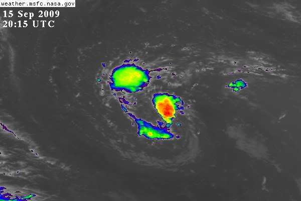
Looks like shear-induced convection from a dying surface feature.
0 likes
-
ozonepete
- Professional-Met

- Posts: 4743
- Joined: Mon Sep 07, 2009 3:23 pm
- Location: From Ozone Park, NYC / Now in Brooklyn, NY
Re: ATL: TROPICAL DEPRESSION FRED (07L)
Sanibel wrote:Looks like shear-induced convection from a dying surface feature.
There's much lower shear there now. Note that the thunderstorm tops are not being blown off - they are staying in place. That indicates no or low shear.
0 likes
-
wxman57
- Moderator-Pro Met
- Posts: 23171
- Age: 68
- Joined: Sat Jun 21, 2003 8:06 pm
- Location: Houston, TX (southwest)
Re: ATL: TROPICAL DEPRESSION FRED (07L) - Computer Models
12Z Euro just loses it after taking it toward the Bahamas/Florida.
0 likes
-
wxman57
- Moderator-Pro Met
- Posts: 23171
- Age: 68
- Joined: Sat Jun 21, 2003 8:06 pm
- Location: Houston, TX (southwest)
Re: ATL: TROPICAL DEPRESSION FRED (07L)
jlauderdal wrote:wxman57 wrote:Shouldn't this discussion be in the Talkin' Tropics area, as Fred is no longer an active storm or an invest?
no because you never posted "Bones"
Soon as I posted that, the NHC started issuing model data again. So never mind.
0 likes

-
Derek Ortt
Re: ATL: TROPICAL DEPRESSION FRED (07L) - Computer Models
I am actually from Liverpool UK, but tropical cyclones have become an interest over the years.
0 likes

-
Blown Away

- S2K Supporter

- Posts: 10253
- Joined: Wed May 26, 2004 6:17 am
Re: ATL: TROPICAL DEPRESSION FRED (07L)
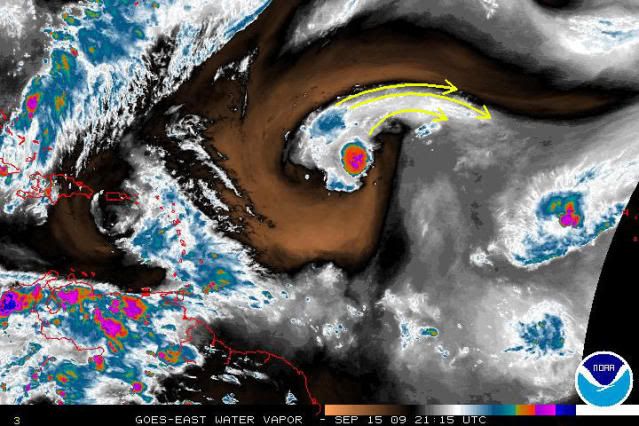
http://www.ssd.noaa.gov/goes/east/tatl/loop-avn.html
0 likes


-
cycloneye

- Admin

- Posts: 149222
- Age: 69
- Joined: Thu Oct 10, 2002 10:54 am
- Location: San Juan, Puerto Rico
Re: ATL: TROPICAL DEPRESSION FRED (07L)
Below is the last advisory when NHC pronnounced Fred dissipated by now but mother nature as a mind of its own.
INITIAL 12/2100Z 17.7N 33.7W 30 KT...REMNANT LOW
12HR VT 13/0600Z 18.1N 34.1W 25 KT...REMNANT LOW
24HR VT 13/1800Z 19.0N 35.1W 25 KT...REMNANT LOW
36HR VT 14/0600Z 19.8N 37.0W 25 KT...REMNANT LOW
48HR VT 14/1800Z 21.1N 39.6W 25 KT...REMNANT LOW
72HR VT 15/1800Z...DISSIPATED
http://www.nhc.noaa.gov/archive/2009/al ... .021.shtml?
0 likes
-
ozonepete
- Professional-Met
- Posts: 4743
- Joined: Mon Sep 07, 2009 3:23 pm
- Location: From Ozone Park, NYC / Now in Brooklyn, NY
Re: ATL: TROPICAL DEPRESSION FRED (07L)
It's definitely in a low shear environment for now, since it is also under the ULL now, as Derek noted. It of course needs to develop an upper anticyclone over it to become any kind of decent tropical cyclone again. But note the outflow plume developing over the northern half of the cyclone. This is helping to enhance the thunderstorm cluster activity by allowing upper level air to be evacuated to the northeast. If this persists, it's within the realm of possibility that outflow could develop in other quadrants, and then Fred would be back in business. But for how long? There are very complex conditions out ahead of Fred...
0 likes
-
ozonepete
- Professional-Met
- Posts: 4743
- Joined: Mon Sep 07, 2009 3:23 pm
- Location: From Ozone Park, NYC / Now in Brooklyn, NY
Re: ATL: TROPICAL DEPRESSION FRED (07L)
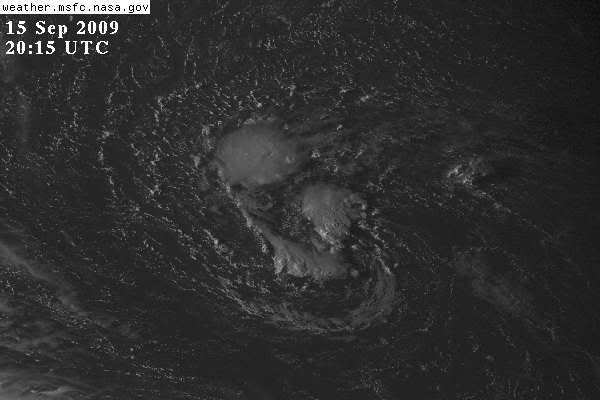
Pretty significant convective blow-up. And not only is it getting over the LLC, but the nocturnal convective activity cycle is just starting. Looks like Code Orange at 11PM.

0 likes
-
curtadams
- S2K Supporter
- Posts: 1122
- Joined: Sun Aug 28, 2005 7:57 pm
- Location: Orange, California
- Contact:
Well, it's had several large blow ups get blown off before so probably premature for a Code Orange. NHC always drags its feet on major changes so I'd expect them to wait for at least 24 hours of strong convection before reactivating.
Has seemed worthy of an invest pretty much the whole time, though, with CMC and NOGAPS generally forecasting a continuing storm.
Has seemed worthy of an invest pretty much the whole time, though, with CMC and NOGAPS generally forecasting a continuing storm.
0 likes
-
jlauderdal
- S2K Supporter
- Posts: 7240
- Joined: Wed May 19, 2004 5:46 am
- Location: NE Fort Lauderdale
- Contact:
Re: ATL: TROPICAL DEPRESSION FRED (07L)
ozonepete wrote:Pretty significant convective blow-up. And not only is it getting over the LLC, but the nocturnal convective activity cycle is just starting. Looks like Code Orange at 11PM.
it can have the biggest best blow up in the world but if the nhc doesnt think it has a 30-50% chance of being a tropical cyclone within 48hrs than it wont be code orange, its that simple.
0 likes
-
Shewtinstar
- Tropical Low

- Posts: 32
- Joined: Wed Aug 26, 2009 10:01 am
Who is online
Users browsing this forum: No registered users and 11 guests