ATL: TROPICAL LOW ex-FRED (ex-07L)

Moderator: S2k Moderators

Message
Author
User avatar
Gustywind
Category 5
Category 5
Posts: 12334
Joined: Mon Sep 03, 2007 7:29 am
Location: Baie-Mahault, GUADELOUPE

#1001 Postby Gustywind » Wed Sep 16, 2009 6:01 pm

Aric Dunn wrote:it is looking pretty meager this evening.. still cant write it off ... just got to keep watching and waiting till its inland or out to sea..


Be confident...he's a fighter :cheesy: ! :D
Image
0 likes   

User avatar
carolina_73
Tropical Storm
Tropical Storm
Posts: 148
Joined: Wed Jul 23, 2008 1:30 am

#1002 Postby carolina_73 » Wed Sep 16, 2009 6:08 pm

looking at the IR loop above that ULL is moving south now breaking away from the remnants of Fred. Anyone else noticed that? Just wondering if that could help him out in the near future :?:
Last edited by carolina_73 on Wed Sep 16, 2009 6:12 pm, edited 1 time in total.
0 likes   

User avatar
gatorcane
S2K Supporter
S2K Supporter
Posts: 23691
Age: 47
Joined: Sun Mar 13, 2005 3:54 pm
Location: Boca Raton, FL

Re: ATL: TROPICAL DEPRESSION FRED (07L)

#1003 Postby gatorcane » Wed Sep 16, 2009 6:11 pm

Yes I do, maybe not by coincidence its starting to burst some new convection near the "center." Let's see if it keeps bursting or it is just temporary.
0 likes   

jinftl
Category 5
Category 5
Posts: 4312
Joined: Tue Aug 31, 2004 4:47 pm
Location: fort lauderdale, fl

Re: ATL: TROPICAL DEPRESSION FRED (07L)

#1004 Postby jinftl » Wed Sep 16, 2009 6:34 pm

That we are even still talking about this system is something of a miracle....on labor day, the biggest question was whether it would recurve at 35W or 40W.

cycloneye wrote:Unless there is a miracle allowing Ex Fred to redevelop,the time for this thread to remain at Active Storms forum is comming sooner rather than later.The archieves forum awaits Ex Fred with open arms :)
0 likes   

User avatar
cycloneye
Admin
Admin
Posts: 145366
Age: 68
Joined: Thu Oct 10, 2002 10:54 am
Location: San Juan, Puerto Rico

Re: ATL: TROPICAL DEPRESSION FRED (07L)

#1005 Postby cycloneye » Wed Sep 16, 2009 6:35 pm

And NHC is still talking about it.

TROPICAL WEATHER OUTLOOK
NWS TPC/NATIONAL HURRICANE CENTER MIAMI FL
800 PM EDT WED SEP 16 2009

FOR THE NORTH ATLANTIC...CARIBBEAN SEA AND THE GULF OF MEXICO...

THE REMNANTS OF FRED...LOCATED ABOUT 600 MILES EAST-NORTHEAST OF THE
NORTHERN LEEWARD ISLANDS...ARE MOVING GENERALLY WESTWARD AT ABOUT
15 MPH. ALTHOUGH THE SYSTEM CONTINUES TO PRODUCE INTERMITTENT
SHOWERS AND THUNDERSTORMS...THE UPPER-LEVEL ENVIRONMENT DOES NOT
APPEAR TO BE CONDUCIVE FOR RE-DEVELOPMENT...AND THERE IS A LOW
CHANCE...LESS THAN 30 PERCENT...OF THIS SYSTEM BECOMING A TROPICAL
CYCLONE DURING THE NEXT 48 HOURS.

ELSEWHERE...TROPICAL CYCLONE FORMATION IS NOT EXPECTED DURING THE
NEXT 48 HOURS.

$$
FORECASTER PASCH/BERG

http://www.storm2k.org/weather/hw3.php? ... hwvmetric=

0 likes   

User avatar
wxman57
Moderator-Pro Met
Moderator-Pro Met
Posts: 22979
Age: 67
Joined: Sat Jun 21, 2003 8:06 pm
Location: Houston, TX (southwest)

Re:

#1006 Postby wxman57 » Wed Sep 16, 2009 7:11 pm

carolina_73 wrote:looking at the IR loop above that ULL is moving south now breaking away from the remnants of Fred. Anyone else noticed that? Just wondering if that could help him out in the near future :?:


I do notice that the wave axis seems to by bypassing the upper low now. Once it's removed from the upper low, there may not be much to sustain any convection tomorrow.
0 likes   

User avatar
Stephanie
S2K Supporter
S2K Supporter
Posts: 23843
Age: 63
Joined: Thu Feb 06, 2003 9:53 am
Location: Glassboro, NJ

Re: ATL: TROPICAL DEPRESSION FRED (07L)

#1007 Postby Stephanie » Wed Sep 16, 2009 7:24 pm

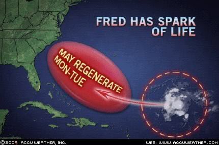
breeze wrote:Accuweather's thinking...


Image


I'll be in the Bahamas then...I hope Fred is dead, instead! :eek:
0 likes   

ozonepete
Professional-Met
Professional-Met
Posts: 4743
Joined: Mon Sep 07, 2009 3:23 pm
Location: From Ozone Park, NYC / Now in Brooklyn, NY

Re: Re:

#1008 Postby ozonepete » Wed Sep 16, 2009 8:05 pm

wxman57 wrote:
carolina_73 wrote:looking at the IR loop above that ULL is moving south now breaking away from the remnants of Fred. Anyone else noticed that? Just wondering if that could help him out in the near future :?:


I do notice that the wave axis seems to by bypassing the upper low now. Once it's removed from the upper low, there may not be much to sustain any convection tomorrow.


Why is that there won't be much to sustain convection? Upper winds will be lighter and more southwesterly ahead of the departing trough - this will help evacuate air from the thunderstorm tops.

It is in a quite moist mid-level water vapor environment:
Image

Shear is very low:
Image

What are the negatives if it gets away from the upper low?
0 likes   

User avatar
brunota2003
S2K Supporter
S2K Supporter
Posts: 9476
Age: 34
Joined: Sat Jul 30, 2005 9:56 pm
Location: Stanton, KY...formerly Havelock, NC
Contact:

#1009 Postby brunota2003 » Wed Sep 16, 2009 8:14 pm

What are the negatives? The fact there is no surface low to produce storms...I expect this'll be like any other tropical wave, producing scattered showers/storms as it marches across the Atlantic. Could it reform? Possibly, but I put that chance closer to 2%.
0 likes   

Derek Ortt

#1010 Postby Derek Ortt » Wed Sep 16, 2009 8:16 pm

a big difference is that upper air temps will be warmer, resulting in a more stable tropopause
0 likes   

ozonepete
Professional-Met
Professional-Met
Posts: 4743
Joined: Mon Sep 07, 2009 3:23 pm
Location: From Ozone Park, NYC / Now in Brooklyn, NY

Re:

#1011 Postby ozonepete » Wed Sep 16, 2009 8:25 pm

brunota2003 wrote:What are the negatives? The fact there is no surface low to produce storms...I expect this'll be like any other tropical wave, producing scattered showers/storms as it marches across the Atlantic. Could it reform? Possibly, but I put that chance closer to 2%.


There is no surface low for any tropical wave. Then what is it that makes them spin up into a surface low? Concentrations of convection which, if persistent, will begin to create a cluster of thunderstorms which evacuate air out into the upper tropopause and stratosphere while pulling in more unstable theta-e air from below. It is still not completely understood, as I'm sure you know, why some clusters of thunderstorms are persistent and eventually "spin up" into a low while others don't. But from observation we know that persistence has often been seen with an ex-tropical cyclone that moves across the Atlantic and then comes under better circumstances. That's why we watch them so carefully. What interests me here is the persistence, which is pretty amazing considering this system has moved over a thousand miles from where it "died out" and is still puffing up thunderstorms.
0 likes   

ozonepete
Professional-Met
Professional-Met
Posts: 4743
Joined: Mon Sep 07, 2009 3:23 pm
Location: From Ozone Park, NYC / Now in Brooklyn, NY

Re:

#1012 Postby ozonepete » Wed Sep 16, 2009 8:31 pm

Derek Ortt wrote:a big difference is that upper air temps will be warmer, resulting in a more stable tropopause


Stable during the day, unstable at night. That's where the diurnal lack of convection and nocturnal flare-up come from, as you know. The thunderstorm tops at night are quite cold and create a strong temperature profile with the very warm air over the ocean. In systems like these, if there's sufficent thunderstorm blow-up overnight, you still have much colder upper temps over the thunderstorm complex carried over during the next daylight hours, and this feeds the convective cycle that can cause intensification.

And of course, that's because tropical cyclones are barotropic, not baroclinic.
0 likes   

Derek Ortt

Re: Re:

#1013 Postby Derek Ortt » Wed Sep 16, 2009 9:02 pm

ozonepete wrote:
Derek Ortt wrote:a big difference is that upper air temps will be warmer, resulting in a more stable tropopause


Stable during the day, unstable at night. That's where the diurnal lack of convection and nocturnal flare-up come from, as you know. The thunderstorm tops at night are quite cold and create a strong temperature profile with the very warm air over the ocean. In systems like these, if there's sufficent thunderstorm blow-up overnight, you still have much colder upper temps over the thunderstorm complex carried over during the next daylight hours, and this feeds the convective cycle that can cause intensification.

And of course, that's because tropical cyclones are barotropic, not baroclinic.


hold on.

Under an upper low, temps are colder aloft. They have to be due to the hypsometric equation, which can easily be derived from the hydrostatic equation.

Once it moves to an area of higher heights, the upper temps are warmer. This is a more stable thermodynamic profile. We don't have anything at the surface to trigger convection now that the low center has degenerated to the point that it has. Therefor,e once out of the UL, convection should also weaken significantly
0 likes   

ozonepete
Professional-Met
Professional-Met
Posts: 4743
Joined: Mon Sep 07, 2009 3:23 pm
Location: From Ozone Park, NYC / Now in Brooklyn, NY

Re: Re:

#1014 Postby ozonepete » Wed Sep 16, 2009 9:19 pm

Derek Ortt wrote:
ozonepete wrote:
Derek Ortt wrote:a big difference is that upper air temps will be warmer, resulting in a more stable tropopause


Stable during the day, unstable at night. That's where the diurnal lack of convection and nocturnal flare-up come from, as you know. The thunderstorm tops at night are quite cold and create a strong temperature profile with the very warm air over the ocean. In systems like these, if there's sufficent thunderstorm blow-up overnight, you still have much colder upper temps over the thunderstorm complex carried over during the next daylight hours, and this feeds the convective cycle that can cause intensification.

And of course, that's because tropical cyclones are barotropic, not baroclinic.


hold on.

Under an upper low, temps are colder aloft. They have to be due to the hypsometric equation, which can easily be derived from the hydrostatic equation.

Once it moves to an area of higher heights, the upper temps are warmer. This is a more stable thermodynamic profile. We don't have anything at the surface to trigger convection now that the low center has degenerated to the point that it has. Therefor,e once out of the UL, convection should also weaken significantly


We don't have anything at the surface to trigger convection? How about a tropical wave?

Is the departure of an upper low with colder temps aloft, thus bringing in warmer temps aloft, always the cause of a complete shutdown of the unstable thermal profile? The profile will obviously be less unstable, but hardly completely unstable. How many times have we seen an upper level low adversely affect a tropical wave exactly in this manner, and then pull away or dissipate, leaving a warmer, more stable upper air environment that almost immediately degenerated into a cluster of strong thunderstorms and tropical cyclone development. It's just not that simple that there will be no thunderstorm development after the ULL leaves. It depends on the upper air configuration that replaces it, and in this case there will be some southwesterlies that will provide lift/evacuation of the air from whatever thunderstorms develop. If you want to talk about temperature profiles and parcels, you have to talk about about non-adiabatic influences on the air parcels that reside over the system.
0 likes   

User avatar
blp
Category 5
Category 5
Posts: 2840
Age: 46
Joined: Thu Sep 09, 2004 7:51 pm
Location: Miami, FL
Contact:

Re: Re:

#1015 Postby blp » Wed Sep 16, 2009 9:31 pm

Stable during the day, unstable at night. That's where the diurnal lack of convection and nocturnal flare-up come from, as you know. The thunderstorm tops at night are quite cold and create a strong temperature profile with the very warm air over the ocean. In systems like these, if there's sufficent thunderstorm blow-up overnight, you still have much colder upper temps over the thunderstorm complex carried over during the next daylight hours, and this feeds the convective cycle that can cause intensification.

And of course, that's because tropical cyclones are barotropic, not baroclinic.[/quote]


hold on.

Under an upper low, temps are colder aloft. They have to be due to the hypsometric equation, which can easily be derived from the hydrostatic equation.

Once it moves to an area of higher heights, the upper temps are warmer. This is a more stable thermodynamic profile. We don't have anything at the surface to trigger convection now that the low center has degenerated to the point that it has. Therefor,e once out of the UL, convection should also weaken significantly[/quote]


We don't have anything at the surface to trigger convection? How about a tropical wave?

Is the departure of an upper low with colder temps aloft, thus bringing in warmer temps aloft, always the cause of a complete shutdown of the unstable thermal profile? The profile will obviously be less unstable, but hardly completely unstable. How many times have we seen an upper level low adversely affect a tropical wave exactly in this manner, and then pull away or dissipate, leaving a warmer, more stable upper air environment that almost immediately degenerated into a cluster of strong thunderstorms and tropical cyclone development. It's just not that simple that there will be no thunderstorm development after the ULL leaves. It depends on the upper air configuration that replaces it, and in this case there will be some southwesterlies that will provide lift/evacuation of the air from whatever thunderstorms develop. If you want to talk about temperature profiles and parcels, you have to talk about about non-adiabatic influences on the air parcels that reside over the system.[/quote]


I have to say I do enjoy this discussion. Quite interesting.... I feel like I am back in school. Thanks guys for the discussion. I learn something new everyday on this board.
0 likes   

User avatar
gatorcane
S2K Supporter
S2K Supporter
Posts: 23691
Age: 47
Joined: Sun Mar 13, 2005 3:54 pm
Location: Boca Raton, FL

#1016 Postby gatorcane » Wed Sep 16, 2009 10:00 pm

I think ozonepete and Derek both bring up good points. I can see this going either way. That is I can see some increased convection blowing up over the next couple of days or a complete lack of it with just a remnant swirl at the surface.

One thing is for sure though, looking at short-wave IR tonight, I see quite a bit of twist still right near or under that area of convection that blew up earlier this evening (now starting to die off some)...and you can see that ULL now to the SE that it is pulling away from.

link:
http://www.ssd.noaa.gov/goes/east/tatl/loop-ir2.html

It will be interested to see what happens. Wouldn't be surprised if we have a tie here and we see some pulsing convection over the next several days as it heads towards the Bahamas.
0 likes   

Derek Ortt

Re: Re:

#1017 Postby Derek Ortt » Wed Sep 16, 2009 10:33 pm

ozonepete wrote:

We don't have anything at the surface to trigger convection? How about a tropical wave?

Is the departure of an upper low with colder temps aloft, thus bringing in warmer temps aloft, always the cause of a complete shutdown of the unstable thermal profile? The profile will obviously be less unstable, but hardly completely unstable. How many times have we seen an upper level low adversely affect a tropical wave exactly in this manner, and then pull away or dissipate, leaving a warmer, more stable upper air environment that almost immediately degenerated into a cluster of strong thunderstorms and tropical cyclone development. It's just not that simple that there will be no thunderstorm development after the ULL leaves. It depends on the upper air configuration that replaces it, and in this case there will be some southwesterlies that will provide lift/evacuation of the air from whatever thunderstorms develop. If you want to talk about temperature profiles and parcels, you have to talk about about non-adiabatic influences on the air parcels that reside over the system.


the wave is fairly poorly defined at the surface now

http://manati.orbit.nesdis.noaa.gov/dat ... MBds99.png

I am not sure it will cause enough convergence to produce convection once this moves away from the UL.

Also, the SW winds aloft will provide some lift. However, the same SW winds aloft also create a warm anomaly aloft on the upshear side (DeMaria 1996), which suppresses convection upshear. Gray (1968) also mentioned the advection of the heat and moisture away from the core. This is not good for redeveloping a nice warm core. At most, we would see the development of yet another highly sheared system along the lines of Danny and Erika
0 likes   

ozonepete
Professional-Met
Professional-Met
Posts: 4743
Joined: Mon Sep 07, 2009 3:23 pm
Location: From Ozone Park, NYC / Now in Brooklyn, NY

Re: Re:

#1018 Postby ozonepete » Wed Sep 16, 2009 11:00 pm

Derek Ortt wrote:
ozonepete wrote:

We don't have anything at the surface to trigger convection? How about a tropical wave?

Is the departure of an upper low with colder temps aloft, thus bringing in warmer temps aloft, always the cause of a complete shutdown of the unstable thermal profile? The profile will obviously be less unstable, but hardly completely unstable. How many times have we seen an upper level low adversely affect a tropical wave exactly in this manner, and then pull away or dissipate, leaving a warmer, more stable upper air environment that almost immediately degenerated into a cluster of strong thunderstorms and tropical cyclone development. It's just not that simple that there will be no thunderstorm development after the ULL leaves. It depends on the upper air configuration that replaces it, and in this case there will be some southwesterlies that will provide lift/evacuation of the air from whatever thunderstorms develop. If you want to talk about temperature profiles and parcels, you have to talk about about non-adiabatic influences on the air parcels that reside over the system.


the wave is fairly poorly defined at the surface now

http://manati.orbit.nesdis.noaa.gov/dat ... MBds99.png

I am not sure it will cause enough convergence to produce convection once this moves away from the UL.

Also, the SW winds aloft will provide some lift. However, the same SW winds aloft also create a warm anomaly aloft on the upshear side (DeMaria 1996), which suppresses convection upshear. Gray (1968) also mentioned the advection of the heat and moisture away from the core. This is not good for redeveloping a nice warm core. At most, we would see the development of yet another highly sheared system along the lines of Danny and Erika


Very good points. Overall, I expect a Danny/Erika end as well. But I can't be convinced of it as yet. The warm anomaly aloft on the upshear side depends on a fairly long imposition of the trough on the tropical cyclone. This trough will be lifting out about the time this wave/trough gets there (by the Bahamas), and could be replaced by a fairly tranquil regime aloft. In that case there won't be any advection of deep moisture away from the core area of thunderstorms. That's a very different scenario from the one you presented, and can't be discounted.
0 likes   

ozonepete
Professional-Met
Professional-Met
Posts: 4743
Joined: Mon Sep 07, 2009 3:23 pm
Location: From Ozone Park, NYC / Now in Brooklyn, NY

Re: ATL: TROPICAL DEPRESSION FRED (07L)

#1019 Postby ozonepete » Wed Sep 16, 2009 11:14 pm

Really enjoyed the discussion Derek. I have to go to bed now. Got to get up at 6 (God help me!) The best part of all of this is that tomorrow almost always brings something we never expected. If it was always what we expected. we'd be bored to death. :)
0 likes   

ozonepete
Professional-Met
Professional-Met
Posts: 4743
Joined: Mon Sep 07, 2009 3:23 pm
Location: From Ozone Park, NYC / Now in Brooklyn, NY

Re: ATL: TROPICAL DEPRESSION FRED (07L)

#1020 Postby ozonepete » Wed Sep 16, 2009 11:17 pm

"I have to say I do enjoy this discussion. Quite interesting.... I feel like I am back in school. Thanks guys for the discussion. I learn something new everyday on this board."

Hey BLP glad you enjoyed it!
0 likes   


Return to “2009”

Who is online

Users browsing this forum: No registered users and 5 guests